Zaculeu: Capital of the Mam Kingdom in Guatemala
Site at a Glance
- Rating
- 4.5
- Popularity
- Medium
- Country
- Guatemala
- Primary era
- Medieval
- Eras represented
- Classical, Medieval, Early Modern
- Civilizations
- Unclassified
- Site type
- City
On this page22 sections
History
Zaculeu is a pre-Columbian Maya archaeological site in Huehuetenango, Guatemala, occupied from about AD 250 to 1525. It became the capital of the Mam kingdom during the Postclassic period, and its buildings preserve successive phases of Mam and K’iche’ political and architectural influence.
Early Maya occupation
Zaculeu was first occupied during the Early Classic period, approximately AD 250–600. Its largest building programme belongs to the broader Classic period, approximately AD 250–900, while further plaza groups and buildings were added during the Early Postclassic, about AD 900–1200, and the Late Postclassic, about AD 1200–1525. Early Classic architecture shows influence from Teotihuacan, the major ancient city in central Mexico whose political and architectural influence extended across Mesoamerica.
Central Mexican influence returned during the Late Classic, possibly through the settlement of a foreign Mexican elite that remained until the K’iche’ conquest. The site continued to develop without a complete replacement of its earlier plan. Later builders placed new structures over Classic-period buildings, creating a complex in which local Mam traditions and incoming influences remained visibly combined.
K’iche’ rule
The K’iche’ kingdom of Q’umarkaj conquered Zaculeu during the Postclassic period. Earlier interpretations placed the conquest in the fifteenth century, but radiocarbon evidence has moved the probable date back as far as the twelfth century. Zaculeu then remained under K’iche’ domination until the Spanish conquest.
Q’uq’umatz, the K’iche’ king, died in battle against northern Mam forces. His successor, K’iq’ab, continued the subjugation of the Mam and ruled when the K’iche’ conquered Zaculeu. The conquest appears to have followed an earlier period of K’iche’ control. Zaculeu was probably placed under the K’iche’ Nija’ib’ lineage, although the Ilocab lineage is another possibility for control of the wider region.
Much of the original Mam population remained at the site. K’iche’ additions included a west-facing temple with a steep talud-tablero facade, a form combining a sloping lower wall with a vertical upper panel, an elongated palace to the north, and a ballcourt to the southwest. These additions were set against an earlier Mam arrangement oriented along a southeast–northwest axis.
Siege and Spanish conquest
During the Spanish conquest, Mam inhabitants from Xinabahul, the settlement now represented by Huehuetenango, took refuge at Zaculeu because of its fortifications. In 1525, Gonzalo de Alvarado y Contreras attacked the site with 120 Spanish soldiers and approximately 2,000 Mexican and K’iche’ allies.
Kayb’il B’alam, the last ruler of Zaculeu, defended the city with approximately 5,000 people. It is uncertain whether this figure refers to warriors or to the total population. After a siege lasting several months, famine forced his surrender in October 1525. Spanish forces found approximately 1,800 dead defenders when they entered the city, and surviving inhabitants were eating the corpses of the dead. Zaculeu was abandoned after the conquest, and the Spanish established the new city of Huehuetenango about 5 kilometres to the north.
Rediscovery and preservation
Mam Maya communities have continued to use Zaculeu as a ceremonial site, including for traditional ceremonies. Its religious and cultural role therefore extends beyond its ancient occupation and remains part of Mam community life.
John Lloyd Stephens and Frederick Catherwood visited Zaculeu in 1840, when the remains were an overgrown jumble of ruins. Stephens published a description in 1841. Catherwood made no architectural drawings because of the poor condition of the structures, although the pair excavated a mound and recovered ceramic vessels that Catherwood drew.
Guatemala declared the site a National Monument on 24 April 1931 under the name Tzaculeu and renamed it Zaculeu on 23 February 1946. After receiving an excavation license, the United Fruit Company began excavations and structural restoration during the 1940s under John M. Dimick. Research from the project was published in two volumes in 1953 by Richard B. Woodbury and Aubrey S. Trik. Several buildings were recoated with white plaster because evidence indicated that they had originally been finished in that way. Zaculeu became a National Pre-Columbian Monument by agreement of Guatemala’s Ministry of Education on 12 June 1970 and is administered by the Institute of Anthropology and History and the Ministry of Culture and Sports.
Remains
Setting and site layout
Zaculeu occupies a plateau about 1,900 metres above sea level, overlooking the Selegua River near the Selegua and Viña rivers and below the Sierra de los Cuchumatanes. Deep ravines border the plateau on the south and east, while a narrow land bridge to the north forms the natural approach from the valley. The Selegua supplied permanent water and provided a route for water transport, while the defensible terrain shaped the site’s development.
The plateau covers approximately 4,191 square metres and originally had a surrounding wall. At the northern entrance, a fortified structure occupied about three-quarters of the width of the land bridge. Within the ceremonial centre, 43 structures occupy approximately 1,400 square metres and are arranged around eight plazas. Most construction belongs to a major Early Classic phase, followed by smaller alterations and later additions.
Construction and decoration
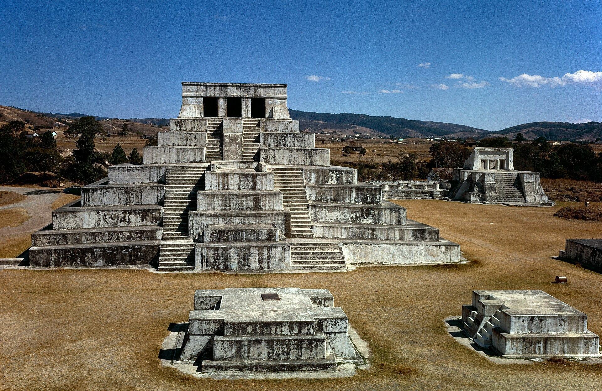
Buildings were generally made from masonry coated with thick plaster. Fragments of the coating carry floral and geometric designs, showing that the buildings were originally painted in vivid colours. The stones were left unworked and bonded with adobe mortar, an earth-based binding material commonly containing clay and other mineral or organic components. The architecture includes sloping-and-vertical talud-tablero facades, double stairways, pyramidal temples, palaces, and cylindrical columns.
Plazas and circulation
Plaza 1 is the principal plaza, measuring approximately 54 by 38 metres and enclosed on all four sides by pyramid temples. Plaza 2 lies southeast of the site core and south of Plaza 1, with Structure 4 on its southeast side, Structure 1 on its northeast side, the ballcourt to the northwest, and Plaza 3 to the southwest. Plaza 3 is a small space at the southern end of the core.
Plaza 4 occupies the northwestern part of the core, bordered by Structure 10, Structure 13, and the ballcourt, with Plazas 5 and 6 immediately to the west. Plaza 5 is a small space northwest of the ballcourt, separated from Plaza 6 by Structure 21. Plaza 6 is enclosed on three sides by a building complex. Plaza 7 lies at the western end of the core, while enclosed Plaza 8 is southwest of the ballcourt, closed on two sides by Structures 2 and 3.
Burials and recovered objects
Principal pyramid tomb
An Early Classic tomb was inserted beneath Zaculeu’s principal pyramid by tunnelling through the volcanic ash beneath the structure. A broad stairway descended from the main plaza to the red-painted interior. The tomb contained the remains of more than 100 ceramic vessels, crushed when its roof collapsed, as well as 34 pyrite mirrors. A large quantity of jade included beads and earplugs, with some beads carved as human and parrot faces.
The burial contained the remains of at least four individuals and decorated ceramic offerings, including tripod vessels, polychrome bowls, and a polychrome cylindrical vase with a painted band of hieroglyphs. One bowl used a negative-painting technique similar to material found at Nebaj. Early Classic burials at the site produced a rich range of objects, while Late Classic burials contained a more limited range of offerings.
Trade objects
Excavations recovered turquoise and metalwork made from gold, silver, copper, and their alloys. These objects point to Zaculeu’s participation in wide Postclassic trade networks connected with Mexico and southern Central America. Among the finds was an ornamental butterfly made from tumbaga, an alloy of gold and copper.
Structure 4 burial
A tomb inside Structure 4 contained a complete skeleton and offerings consisting of two tripod earthenware bowls, one decorated with duck effigies, a tripod incense burner, a flint knife, nine obsidian knives, five jade beads, and gold fragments.
Temples and palaces
Structure 1
Structure 1 is a 12-metre-high pyramid on the southeastern side of Plaza 1. It has eight stepped sections and a summit shrine with three doorways, reached by a double stairway from the plaza. The pyramid was rebuilt seven times. Its visible remains include Early Postclassic work, while its earliest construction phase dates to the Early Classic.
Structure 4
Structure 4 is an unusual temple-palace on the southeastern side of Plaza 2. A central pyramidal base is flanked by two attached ranges of unequal size, each containing a single long room on a low platform. Its summit shrine has three rooms, the last of them circular. Three steep stairways with balustrades lead upward, including a central stairway from the plaza and two lateral stairways set at right angles to it. Each balustrade ends in a vertical panel.
The facade remains in good condition, although the roof is missing. Rows of columns once stood in the attached rooms, and their lower stumps survive. The building is K’iche’ in style and resembles the Temple of Awilix at Q’umarkaj, the principal capital of the K’iche’ kingdom. Its arrangement probably formed part of a K’iche’ complex associated with the Nija’ib’ lineage.
Structures 6, 9, and 13
Structure 6 is a temple on the northeastern side of Plaza 1. Stepped sections support a summit shrine reached by a stairway that divides near the top. The lower sections of the shrine walls and its columns survive. Structure 9 is a large mound on the northwestern side of the same plaza. Its final construction phase appears to have been interrupted by the Spanish conquest, leaving terraces incomplete. Early Classic ceramic caches were found beneath it.
Structure 13 stands on the southwestern side of Plaza 1 and separates that plaza from Plaza 2. A double stairway led from Plaza 1 to its first level, followed by a broad stairway to the summit shrine. The lower sections of the superstructure’s walls and columns remain. Its earliest phase dates to the Early Classic and consisted of a low platform supporting an upper structure made from perishable materials.
Structures 2, 3, 10, 17, and 21
Structure 2 is a largely unrestored pyramid on the northwestern side of sunken Plaza 8. Opposite it, Structure 3 is a platform on the southeastern side of the plaza, immediately south of the ballcourt. It faces northwest and has a double stairway.
Structure 10 borders the northeastern side of Plaza 4. Portions of its original stonework survive, and three stairways led into a long building containing several doorways and a single long room. Structures 15 and 16 are low platforms in Plaza 2, aligned along an axis running northwest from the central temple of Structure 4. Structure 17 is a pyramidal base west of them, supporting two rooms reached by a double stairway. Only the lower portions of the outer room’s walls and entrance columns survive. Structure 21 is a partially restored low platform in Plaza 5 with a stairway on its northwestern side.
Ballcourt and outer structure
Ballcourt
The ballcourt consists of Structures 22 and 23. It is a sunken, I-shaped court with sloping walls, oriented northwest–southeast and measuring approximately 48 metres in length. The side structures once supported buildings, of which the lower wall sections remain. The court was used for the ceremonial Mesoamerican ballgame, a formal ritual and athletic practice played in purpose-built enclosures.
Structure 37
Structure 37 lies outside the eight-plaza core, approximately 50 metres northeast of Structure 4 and a similar distance east of Structure 1. It was investigated archaeologically but not restored. Some original stonework and plaster coating remain visible.
Layered architectural traditions
The K’iche’ arrangement probably included a west-facing temple associated with the Nija’ib’ lineage, a longer palace to its north, and the ballcourt to the southwest. Earlier Mam buildings were reused rather than removed, distorting this arrangement and leaving the two architectural traditions combined across the surviving site.