Khinnis Reliefs: An Assyrian Hydraulic and Rock-Art Complex in Iraq
Site at a Glance
- Rating
- 4.5
- Popularity
- Very Low
- Country
- Iraq
- Primary era
- Iron Age
- Eras represented
- Iron Age, Classical
- Civilizations
- Ancient Greek, Assyrian, Parthian
- Site type
- Infrastructure
- Remains
- Canal
On this page13 sections
History
Khinnis Reliefs is an Assyrian archaeological complex beside the village of Khinnis on the right bank of the Gomel River in Iraq. Constructed around 690 BCE during the reign of Sennacherib, the Neo-Assyrian king who ruled from 705 to 681 BCE, it formed the fourth and final stage of a major hydraulic program serving Nineveh.
Sennacherib’s hydraulic program
The wider project began two years after Sennacherib came to the throne and eventually extended for approximately 150 km through canals, tunnels, and aqueducts. It took about fifteen years to complete. The system brought water from the northern mountains to Nineveh, its palace gardens, plantations, fields, and surrounding countryside. By making grain cultivation possible south of the capital, it supported Sennacherib’s plans to enlarge and provision Nineveh.
At Khinnis, the Gomel River was diverted through a canal approximately 51 km long. The canal began where the river emerged from a narrow gorge in the Zagros Mountains and carried water toward a tributary of the Khosr, eventually supplying Nineveh. The Khinnis canal and the Jerwan aqueduct made up the final phase of the project. Earlier stages included the Kisiri canal, the Musri canal system, and a less fully understood northern network.
The inscription at Khinnis names the canal Nār-Sennacherib and states that the king had eighteen canals dug. It says that seventy men completed this canal in one year and three months. Water from it was combined with supplies from earlier wells and canals before continuing toward Nineveh. The reliefs and inscriptions presented this work as a royal achievement, linking control of water with the prosperity and authority of the Assyrian state.
Ceremony, warfare, and royal power
The same inscription describes the ceremonial opening of the canal. An exorcist and a singer of laments led the proceedings, while offerings of precious stones, oil, gold, silver, oxen, sheep, turtles, and tortoises were made to Ea, Enbilulu, and En’e’imdu. The workers received linen garments, gold rings, and gold pectorals as rewards.
The inscription connects the year after the canal’s opening with Sennacherib’s campaign against Elam, Babylon, and their allies. It also describes the siege and destruction of Babylon in 689 BCE, including the diversion of water across the city’s ruins. The account therefore presents water management as a power that could sustain cultivation and construction, but could also be turned against an enemy.
Sennacherib stated that six stelae showing the great gods and the king in a humble posture were made at the canal entrance. Their surfaces carried an account of his works, and the king placed a curse on any later ruler who altered, dismantled, or diverted the canal system.
Later use and archaeological investigation
The complex was later reused as a hermitage by monks of the Church of the East, a historic Christian church that maintained monastic communities across Mesopotamia. Its modern recognition began in 1846, when Simon Rouet, the French consul in Mosul, is credited with discovering the site. Austen Henry Layard described it in 1853, copied its inscriptions, recorded the reliefs, examined later tombs, and conducted excavations.
Further investigations were undertaken by Eduard Sachau in 1898, Leonard W. King in 1904, Gertrude Bell in 1909, William and Edgar Wigram with Walter Ernst Bachmann in 1914, Thorkild Jacobsen and Seton Lloyd in 1934, and David Oates in 1953.
From 2012 to 2025, the Land of Nineveh Archaeological Project of the University of Udine, led by Morandi Bonacossi, surveyed, digitally recorded, cleaned, and restored the complex with laser scanning. The work formed part of a wider project to create Sennacherib’s Archaeological Park, which also includes the reliefs at Maltai and Faida and the Jerwan aqueduct.
The Directorate of Antiquities of Dohuk is responsible for the site. Khinnis was placed on the World Monuments Watch list in 2014, and the complex has been fenced and monitored with cameras and guards. Preservation work has cleared debris, cleaned the tunnel waterways, installed benches, and added solar-powered lighting.
Natural erosion, weathering, rockfalls, biological growth, plant roots, treasure hunting, graffiti, fires, climbing, thrown stones, litter, and bullet impacts have damaged the remains. Four burial chambers cut into the Great Relief and two rock-cut graves in the Rider Relief caused particularly substantial harm. A dam built approximately 500 m upstream in the 2000s, known as the Daryan or Khinnis Dam, may affect groundwater levels and poses a potential threat. Illegal construction, including an unfinished planned restaurant, has also affected the site.
Remains
The complex is arranged around a hydraulic installation at the point where the Gomel River, called the Atrush in its upper course, leaves a gorge cut through the Zagros Mountains. Its principal elements are a dam, canal, channel entrance, rock reliefs, inscriptions, recessed stela-like panels, a monolith, and a decorated well. The reliefs face the river, and the structures were built mainly from local limestone taken from two quarries. The bedrock belongs to the Miocene Fatha Formation and is approximately 13.8 to 16 million years old.
Dam and canal works
Dam and water control
The dam was constructed from dressed limestone blocks and reached up to 8 m in height. It diverted the Gomel River into the canal running through the Khinnis gorge. The canal had a carefully regulated gradient of approximately 0.1 to 0.3 percent, allowing a steady flow while limiting erosion.
In narrow sections, heavy basalt blocks stabilized the channel and were joined with iron clamps. Remains of limestone overflow channels and sluices survive as evidence of systems used to regulate water levels. Side valleys were crossed by masonry aqueducts comparable to those at Jerwan, while the canal entrance, known as Bāb Nahr, or “Canal Gate,” contains a rock-cut inscription panel.
Well and monolith
A square basin formed the site’s well. Its outlet was decorated with two lions, which were still partly visible in photographs from 1935 but are now scarcely recognizable.
The Monolith, also called the Gate Monument, was carved from a natural rock projection beside Bāb Nahr, to the right of the Great Relief. It later collapsed into the river, although much of the monument still projects above the water. Two rectangular surfaces carried carved scenes, including royal and divine figures.
The reconstructed front composition showed Aššur, the chief god of the Assyrian state, and Mullissu, a major Assyrian goddess associated with Aššur, standing on their associated animals and flanked by two images of Sennacherib. The scene also included Sennacherib with Aššur. A frontal, long-haired hero held a sickle sword in his right hand and a small lion in his left. Two large profile-view lamassu, protective supernatural figures with human heads and animal bodies or wings, flanked him with their heads turned around the monument’s corners. The hero resembles figures of Gilgamesh from the Neo-Assyrian palace at Dur-Sharrukin.
The partly submerged side relief repeated the main group from the Great Relief but omitted Mullissu. Three frontal figures stood on pedestals of equal type and height, with the central god slightly larger. Both the god and the king held maces in their right hands, while frontal lamassu figures flanked the composition.
Rock reliefs
Great Relief
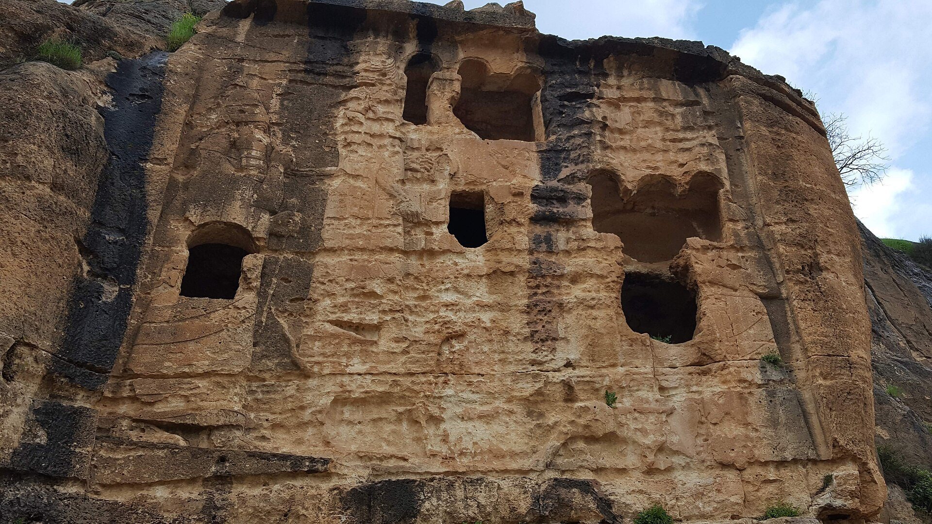
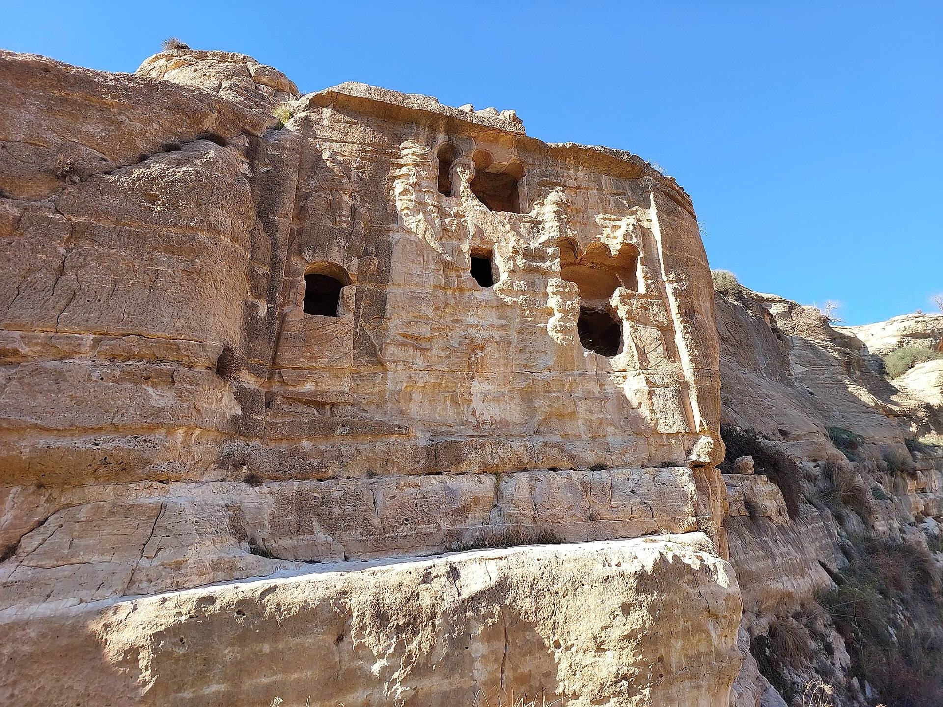
The main relief complex extends from the Rider Relief on the left through the Great Relief to the Monolith. Twelve additional small reliefs, panels, or niches occupy different elevations along the cliff, most of them to the right of the Great Relief. The Great Relief measures approximately 9 by 9 m and contains four standing figures, each about 6.5 m high.
From left to right, the figures represent Sennacherib, Aššur, Mullissu, and Sennacherib again. In the left-hand royal image, Sennacherib raises one hand near his nose as a gesture of worship and holds a hammer, a sign of royal authority, in the other. Aššur and Mullissu face each other while standing on mušḫuššu, mythological horned creatures used as attributes or mounts of Mesopotamian deities. They hold their divine attributes, and the second royal figure stands at the right edge of the composition.
Four burial chambers were cut into the relief during the second to fourth centuries CE, causing major damage. Above it, Walter Bachmann identified several pedestals decorated with lion heads, suggesting that statues once stood there. The relief is characterized as the largest surviving single Assyrian sculpture, showing a pair of gods attended by repeated images of the Assyrian king.
Rider Relief
The Rider Relief lies to the left of the Great Relief and measures approximately 4.2 by 6.7 m. Repeated alterations, two rock-cut graves, chiseling, and natural weathering have left it in poor condition.
Photographs taken by Gertrude Bell in the early twentieth century show figures that are no longer clearly recognizable. Remains at the right edge probably represent Sennacherib, indicated by the diagonal tassel of his royal ritual garment. A second large figure facing right may represent another king of similar size.
Historical photographs show two small figures with raised right arms standing on animals in the upper-left corner and moving toward the left. Fragments of a third similar figure remain, together with an animal bearing a curled horn and what may be the raised arm of another human figure.
The central mounted figure was added later rather than forming part of the original Assyrian image. It probably dates to the Greek or Parthian period and shows a rider in three-quarter view with a visible left shoulder. The rider wears a torc, a rigid or semi-rigid neck ring used as an ornament or status object. The missing right arm may have held a lance, and a possible remnant of the weapon appears near the horse’s neck.
Folds run from both shoulders toward the rider’s waist. Two straight parallel bands cross the horse’s body and may represent the edges of a strap attached to a saddlecloth or a decorated breastband. Parts of the horse’s eye, muzzle, and forelegs survive. No definitive reconstruction has been established. Julian Reade proposed that an inscription may once have occupied this area and suggested that the rider commemorated the Macedonian victory at Gaugamela in 331 BCE, possibly representing Alexander. The image was later modified with Parthian stylistic elements.
Stela-like niches and inscriptions
Twelve stela-like niches, each more than 2 m high, are distributed across the upper cliff on both sides of the Great Relief. A stele is an upright stone monument or inscribed slab, while a niche is a recessed space cut into a wall or cliff. Some of the Khinnis niches are accessible, while others are high above the river and almost invisible from below. Each depicts Sennacherib worshipping beneath sacred symbols.
The symbols form four groups. Three tiaras represent Aššur, Anu, and Enlil, accompanied by an altar bearing a ram-headed staff for Ea, the god associated with subterranean fresh water, wisdom, and ritual knowledge. A crescent represents Sin and a winged disk represents Shamash. Another group consists of a pedestal bearing a trident and three staffs for Adad, Marduk, Nabu, and Nergal. The final group shows a flower with seven stars representing Ishtar and the Sebitti.
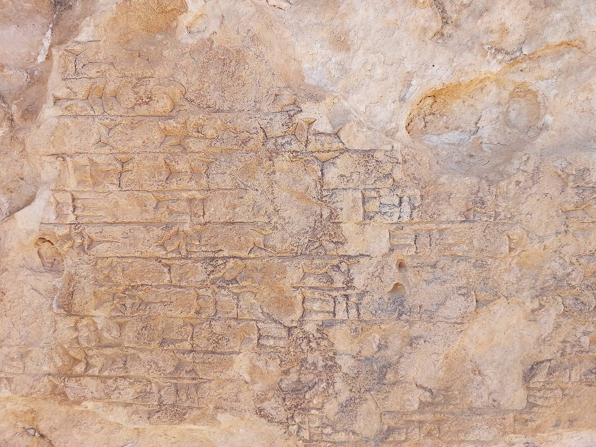
Niches 4, 7, and 11 contain portions of the Bavian Inscription in Akkadian. The text describes the enlargement of Nineveh, the irrigation of previously dry land, the canal excavation, the opening ceremony, Sennacherib’s military campaigns, and the creation of the royal and divine stelae.
Condition of the remains
The limestone reliefs and associated structures survive in varying states of decay. Erosion and weathering have removed softer stone, while rockfalls have detached sections of the cliff. Bacteria and lichens have formed layers several millimetres thick, and carbonate concretions cover some surfaces. Plant roots have also damaged the stone.
The reliefs and tombs have been described as among the finest ancient rock carvings in the Badinan Region. Their surviving combination of hydraulic works, royal inscriptions, divine imagery, later burials, and altered figures preserves the physical history of the complex across several periods.