Nippur: Ancient Sumerian Cult Centre in Iraq
Site at a Glance
- Rating
- 4.4
- Popularity
- Very Low
- Country
- Iraq
- Primary era
- Bronze Age
- Eras represented
- Stone Age, Bronze Age, Iron Age, Classical, Medieval
- Civilizations
- Akkadian, Assyrian, Babylonian, Parthian, Sassanid, Sumerian
- Site type
- City
On this page21 sections
History
Nippur is an ancient Sumerian city and the principal cult centre of Enlil, located near Afak in Al-Qadisiyyah Governorate, Iraq. Occupied from at least the Ubaid period, approximately 5400 to 4000 BC, it remained inhabited through the Uruk, Jemdet Nasr, Early Dynastic, Akkadian, Ur III, Babylonian, Kassite, Assyrian, Neo-Babylonian, Achaemenid, Seleucid, Parthian, Sasanian, and early Islamic periods. Although Nippur was not a major political capital, control of the city and access to the Ekur, Enlil’s principal sanctuary, helped rulers claim divine approval and legitimacy.
Early Sumerian and Akkadian Nippur
Nippur stood near the cultural boundary between predominantly Sumerian southern Mesopotamia and the more Akkadian north. Its population appears to have remained mainly Sumerian, while the city’s religious importance grew during the third millennium BC. Enlil was associated with cosmic authority, the determination of human destinies, and the granting of kingship. Ninurta, Inanna, and other deities also had important cults at Nippur.
During the Early Dynastic period, Nippur belonged to political leagues of southern Mesopotamian cities and may have hosted their assemblies under Enlil’s symbolic authority. Its rulers used the title ensi, but the city did not establish a long-lived royal dynasty of its own. The Tummal Chronicle links early building and cult activity at the Ekur with rulers including Enmebaragesi and Aga of Kish, Mesannepada and Meskiang-nunna of Ur, Gilgamesh and Ur-Nungal of Uruk, and Nanni and Meskiang-nanna of Ur. The chronology and historical reliability of this tradition are not uniform.
Sargon of Akkad conquered Nippur around 2340 BC, after which the Akkadian rulers preserved its status as a holy city. Naram-Sin and Shar-kali-sharri carried out major work at the Ekur, and Naram-Sin’s daughter served as Enlil’s high priestess. Nippur took part in revolts against Naram-Sin but was later brought back under Akkadian control.
The city’s institutions administered agricultural land, dependent labour, rations, stored goods, and temple production. Archives also concern the temples of Enlil and Ninurta, a large agricultural estate known as the Onion Archive, and private legal and commercial activity. These records show that Nippur’s religious importance was supported by extensive economic administration.
The Ur III and Old Babylonian periods
Under the Third Dynasty of Ur, or Ur III, which ruled much of southern Mesopotamia from approximately 2112 to 2004 BC, Nippur remained a major religious centre. Ur-Nammu remodelled the Ekur and erected its ziggurat, a monumental stepped platform supporting a shrine at its summit. Shulgi rebuilt the temple of Inanna and reconstructed or extended the city wall. Ur III rulers were crowned first at Nippur before ceremonies at Ur and Uruk, while Nippur, Drehem, and nearby Tummal may have served as royal residences and administrative centres during the reigns of Shulgi and Amar-Sin.
Nippur maintained close links with Puzrish-Dagan, modern Drehem, an Ur III redistribution centre where livestock from across the empire was collected and allocated. The temples of Nippur were principal recipients of animals for ritual use. More than 3,300 tablets from the city belong to this period and include temple archives, agricultural records, ration lists, contracts, and private transactions.
As Ur III declined, Nippur passed between the rulers of Isin, Larsa, and Babylon. Sumu-El of Larsa temporarily took the city from Isin, Warad-Sin brought it permanently under Larsa during the first half of the nineteenth century BC, and Sîn-muballit of Babylon briefly occupied it. Hammurabi captured Nippur around 1764 BC after defeating Larsa. Possession of the city carried political meaning because it represented selection by Enlil for rule over southern Mesopotamia.
The early Old Babylonian period produced extensive administrative, legal, literary, and school archives. Temples remained important economic institutions, while hereditary or transferable prebends, income-bearing temple offices, gave elite families access to temple work, land, and revenue. Religious women dedicated to deities, particularly Ninurta, lived in a separate institutional quarter and could own, buy, sell, and lend property.
Nippur was partly or entirely abandoned during the eighteenth or seventeenth century BC. Following the revolt against Babylon during the reign of Samsu-iluna, the city passed around 1710 BC to Ilum-ma-ili, founder of the First Dynasty of the Sealand. It was attacked again under Ammi-ditana, and the Ekur was plundered. Nippur’s cults were temporarily transferred elsewhere. Economic and ecological pressures, shifting river channels, declining irrigation, and advancing dunes contributed to the city’s depopulation.
Kassite revival and later decline
Nippur was reoccupied during the Kassite period, particularly from the late fourteenth and early thirteenth centuries BC. The Kassite dynasty ruled Babylonia through much of the second millennium BC. Restoration of irrigation, rebuilding of the city wall, and renewed temple activity formed part of a wider reurbanization of central and southern Babylonia. A canal project associated with Kashtiliash III suggests that efforts to restore the water supply may have begun around 1500 BC, while temple restoration and offerings are recorded under Kurigalzu I.
The Kassite administration gave Nippur a distinctive provincial status. Its governor held the title shandabakku, rather than the ordinary title used by other provincial governors, and sometimes also bore the religious title neshakku of Enlil. The governor supervised temples, agricultural estates, irrigation, taxation, dependent labour, legal proceedings, and provincial correspondence. Around 12,000 Kassite tablets from Nippur include the governor’s archive, temple records, administrative documents, letters, legal texts, and school tablets.
These archives concern farming, pastoral production, craft work, taxation, grain distribution, slavery, horse breeding, irrigation maintenance, and temple estates. They also record communication with the Kassite court and other governors. Nippur continued to be a centre of scribal education, including instruction in Sumerian.
The conflicts that ended Kassite rule damaged the city. The Elamite ruler Kidin-Hutran captured Nippur during the reign of Adad-shuma-iddina, while later instability involved Aramaean and Sutean groups. During the reign of Adad-apla-iddina, the city was captured again, and later traditions describe the sack of Nippur and the seizure of Enlil’s cult statue. The cult was restored, but the city and its institutions declined sharply, probably also affected by the westward movement of the Euphrates.
First-millennium BC occupation
After a long gap in the archaeological and written record, Nippur began to grow again around the mid-eighth century BC, probably when the Euphrates once more approached the city. Aramaean and Chaldean groups occupied the surrounding region, and Nippur enjoyed considerable autonomy. A group of 128 tablets associated with an official named Kudurru records economic activity, agricultural estates, trade, and contacts extending to Assyria and Elam.
During the Assyrian period, Nippur alternated between pro-Assyrian and anti-Assyrian factions and suffered attacks. Under direct Assyrian rule, its governors were appointed by the imperial administration. Sargon II granted the city an exemption privilege, while Sennacherib attacked it. Esarhaddon and Ashurbanipal restored the temples of Ishtar and Enlil, rebuilt the ziggurat, and strengthened the city wall. Nippur also housed an Assyrian administration and probably a military garrison.
When Nabopolassar revolted against Assyria in 626 BC, Nippur became an Assyrian headquarters in Babylonia. It endured attacks and at least one prolonged siege. Documents from this period describe severe hardship and the sale of children into slavery by families apparently trying to survive famine. Nippur probably came under Babylonian control between approximately 620 and 607 BC.
Under the Neo-Babylonian and Achaemenid empires, Nippur remained occupied but was less prosperous than major western Babylonian cities. Its economy depended heavily on cereal cultivation and temple institutions. The Achaemenid Empire, the Persian state that ruled Babylonia from 539 to 331 BC, is especially well represented by the Murashu archive. More than 700 tablets, mainly dating from approximately 454 to 404 BC, record landholding, irrigation, taxation, military obligations, credit, and agricultural leasing. The Murashu family leased large estates, divided them into smaller holdings, supplied equipment and irrigation, collected rents and taxes, and lent money against land.
Seleucid, Parthian, Sasanian, and Islamic periods
Nippur remained an important city under Seleucid and Parthian rule. The Ekur continued to function under an administrator and a governing college, although the former temple precinct was eventually converted into a fortress. The Parthian city covered a large area, and a garrison may have departed around AD 165 when troops were called north for conflicts with Rome.
Nippur reached its greatest extent during the Sasanian period. Important canals were constructed or maintained, and the city produced incantation bowls in Aramaic, Mandaic, and Syriac, mainly from the fifth to seventh centuries AD. These objects reflect Jewish, Mandaean, Manichaean, and other religious communities and were intended to repel illness, demons, and other misfortunes.
The city remained inhabited during the early Islamic period and appears in the writings of Muslim geographers under forms of the name Niffar or Nifr. It was associated with the Nahr al-Nars canal and remained a Christian bishopric of the Church of the East until the bishopric was transferred in the late tenth or early eleventh century. A Jewish settlement also existed on the mounds, probably from the early Islamic period and possibly earlier. Nippur later declined and was finally abandoned at an uncertain date in the thirteenth or fourteenth century AD. The ancient name survived in the modern place-name Nuffar.
Excavation and historical importance
Austen Henry Layard briefly examined Nippur in 1851. The first large-scale excavation was undertaken by the University of Pennsylvania’s Babylonian Expedition from 1888 or 1889 to 1900 under John Punnett Peters, John Henry Haynes, and Hermann Volrath Hilprecht. Work focused on the temple area, Tablet Hill, and parts of the western mound, recovering more than 30,000 cuneiform tablets. Cuneiform, the wedge-shaped writing system of Mesopotamia, recorded administrative accounts, legal agreements, royal inscriptions, religious texts, literary works, school exercises, and private transactions.
Excavations resumed in 1948 through a joint expedition of the Oriental Institute of the University of Chicago and the University of Pennsylvania. After 1962, the University of Chicago continued independently. Campaigns lasted until 1990 and examined temples, Tablet Hill, residential areas, city walls, the Parthian fortress, and other sectors. Preliminary work resumed in 2018, followed by renewed excavations under Abbas Alizadeh in 2019. Recent investigations have concentrated on Parthian and Sasanian buildings, the Ekur, southern neighbourhoods, the city wall, early first-millennium BC houses, bread ovens, possible shipping installations, and Parthian graves.
The excavated archives make Nippur an exceptional centre for studying administration, law, religion, literature, scribal education, economy, and social organization. They span the Early Dynastic, Akkadian, Ur III, Old Babylonian, Kassite, Neo-Assyrian, and Achaemenid periods, while literary and scholarly works include hymns, laments, myths, lexical lists, mathematical and geometric exercises, and compositions associated with the Gilgamesh tradition.
Remains
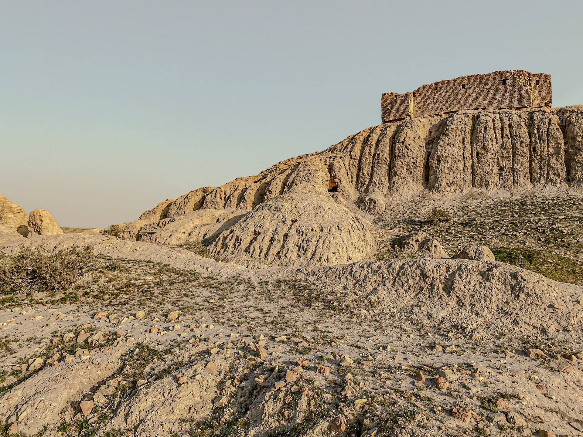
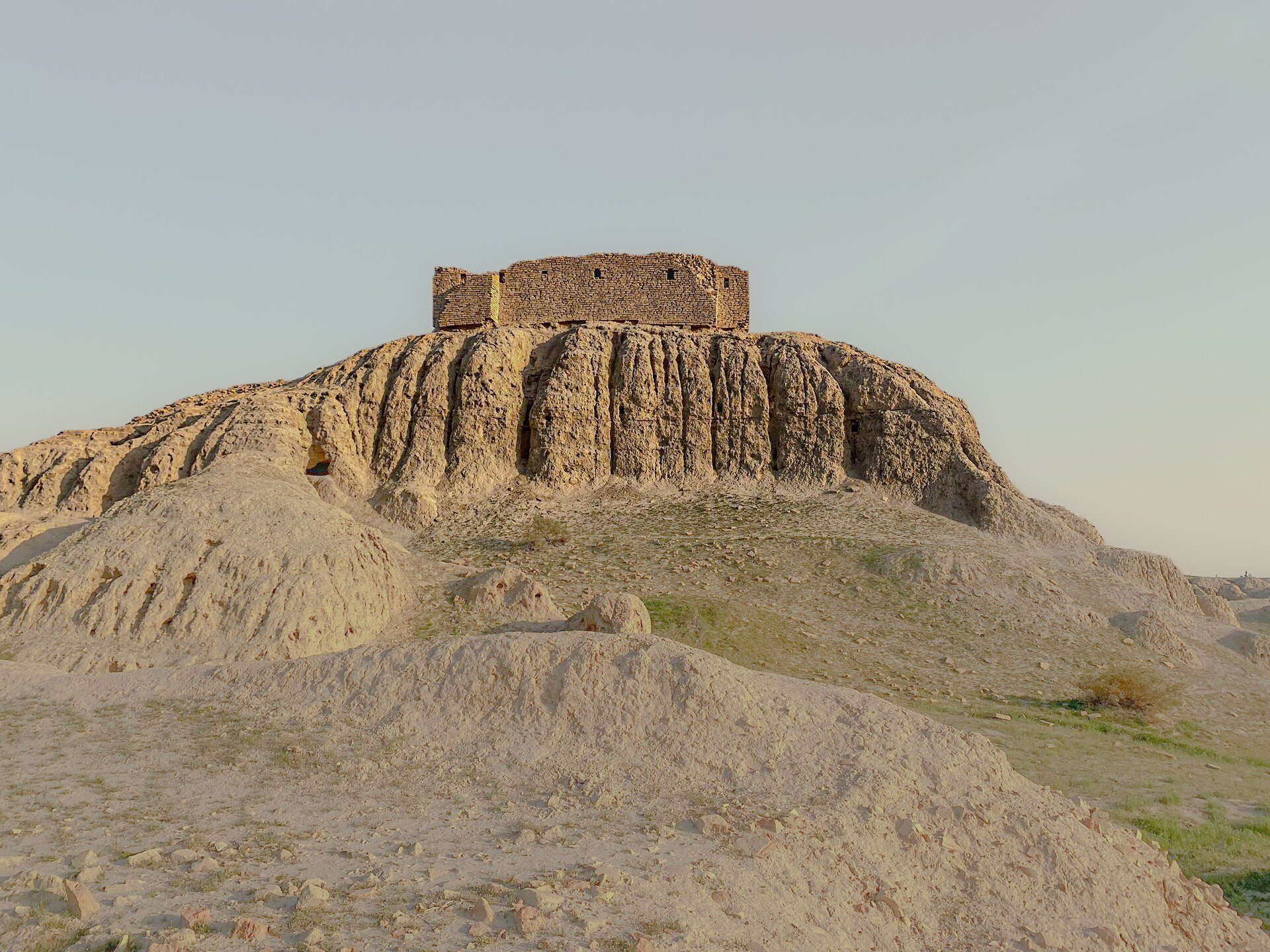
Nippur occupies approximately 150 hectares beside the ancient Shatt en-Nil, an old channel of the Euphrates between the present Euphrates and Tigris. The dry channel divides the site into eastern and western mounds. The highest point is the conical mound called Bint el-Amir, which rises about 30 metres above the surrounding plain. The western mound rises roughly 20 metres above the plain, while the eastern side contains the temple mound to the north and Tablet Hill, or the Scribal Quarter, to the south. The maximum urban extent reached approximately 130 to 135 hectares during the Ur III and Kassite periods.
Walls, canals, and urban layout
A city wall enclosed Nippur. An early wall stood north of the temple sector during the Early Dynastic period, while a southwestern wall dates from the Ur III period and was rebuilt under the Kassites. The Ur III expansion may have increased the enclosed area from approximately 80 to 135 hectares.
A fragmentary Kassite clay map shows the wall, seven named gates, the Ekur, the temple of Ninlil, a large inner-city garden, the Shatt en-Nil along the western side, and another canal to the north. A canal divided the city, while quays or broad banks ran along parts of the walls. The city’s arrangement changed repeatedly as neighbourhoods were abandoned and settlement shifted toward the western mound. The changing Euphrates course and the repeated restoration or failure of irrigation prevent one urban plan from representing every period.
Temple mound
The Ekur and ziggurat
The Ekur occupied the centre of the temple mound. Its name means “House-Mountain,” and the sanctuary was Enlil’s principal temple. Rebuilt many times, it retained a broadly similar arrangement through the Neo-Babylonian period. A large courtyard formed the centre of the complex, which was enclosed by a wall and surrounded by subsidiary rooms. Other features included additional courts, priestly residences, storage facilities, a possible ritual kitchen, a chapel, a divine assembly court, and a large garden.
The Ekur’s ziggurat, ceremonially called Esagdil, stood within the complex. A ziggurat was a stepped mud-brick platform faced with fired brick and crowned by a temple or shrine. The recorded base measured approximately 57 by 39.4 metres, while archaeological measurements give about 58 by 39 metres and a height of approximately 25 metres. Three stages of unbaked brick were faced with fired bricks set in bitumen. An approach on the southeastern side led upward to a shrine at the summit.
Carefully differentiated brick courses formed the structure. A fired-brick drainage conduit ran through it, with bitumen plaster and sloping surfaces to carry water away. Cruciform pavements extended about 12 metres from the base and continued roughly 2.4 metres below the foundation level, helping protect the foundations from rainwater.
Enlil’s temple
The Ur III temple of Enlil stood northeast of the ziggurat and measured approximately 45 by 21 metres. Its northeastern and southwestern walls contained entrances. Floors were paved with square fired bricks about 37 centimetres wide, while the walls were built of straw-tempered mud brick set in mud mortar. Wall thickness ranged from about 3.35 to 3.95 metres, and the building may have reached approximately 13.2 metres in height.
The temple contained two cellae, the principal sacred rooms of a temple, two subsidiary chambers, and smaller rooms linked by unusually wide doorways. Burning traces and inscriptions suggest that food may have been prepared there for the deity associated with the adjacent ziggurat. The building may therefore have served ritual offerings rather than functioning as Enlil’s main worship hall.
The temple of Ninlil
The temple of Ninlil, Enlil’s consort, stood near the Ekur. Its ceremonial name was Ekiur, and its cella had a ceremonial name translated as the “House, Chamber of the Stool.” The complex included a “House of the Ladies” and other subsidiary buildings. Texts also mention a separate joint temple of Enlil and Ninlil, although its exact architectural location is uncertain.
Other temple remains
The temple of Ninurta, called Eshumesha, was an important sanctuary but has not been securely located. Texts describe a large courtyard and buildings for temple personnel and storage. A temple of Nusku was also recorded at Nippur and was associated with Enlil, Nusku’s consort Shuzianna, and the divine twins Lugal-irra and Meslamta-ea.
The North Temple stood in the northern part of the eastern city. Its construction began at least during Early Dynastic I, approximately 2900 to 2750 BC, and it was abandoned near the end of the Akkadian period. A courtyard surrounded by storerooms and kitchens led to a sanctuary with an altar and offering table.
The Inanna temple
The temple of Inanna, also identified with Ishtar, stood southwest of the Ekur. It was known by the ceremonial names Eduranki and Ebaradurgara. Its earliest remains date to the Middle Uruk period, around the middle of the fourth millennium BC, although the building may not yet have had a cultic function at that stage. Rebuilt approximately ten times, it continued in use until the Parthian period.
Early levels included a cella or open ritual area. Later levels contained enlarged courts, rooms, a portico, and two cellae, one preceded by an antechamber. Votive deposits included figurines, relief plaques, inscribed stone vessels, mother-of-pearl inlays, and other objects. One inscribed vessel was dedicated by Aka-Enlil, a leader of merchants, and another by He-Utu.
Shulgi rebuilt the temple at the beginning of the twenty-first century BC. The Ur III building measured approximately 100 by 50 metres and was arranged around several courtyards. Its northeastern sector may have served as a temple chancellery. Later levels belong to the Isin-Larsa, Kassite, and Neo-Assyrian periods.
The Parthian temple was rebuilt on the same site after a foundation platform had been created. It formed a large rectangular building of approximately 70 by 100 metres with two parallel cellae. Its architectural sequence represents approximately 3,500 years of continuity for one Mesopotamian building.
Western mound buildings
The temple of Gula
The temple of Gula occupied area WA on the western mound. Its earliest identified construction dates to the Isin-Larsa period, with major rebuilding during the Kassite, Neo-Assyrian, and Neo-Babylonian periods. The building measured approximately 100 by 40 metres and followed a conventional temple plan. Votive deposits included many dog figurines, reflecting Gula’s association with healing and dogs, as well as an inscribed lapis-lazuli object confirming the identification.
The Kassite palace and large buildings
A Kassite palace in area WB was probably the residence of the city governor. Although poorly preserved, it yielded administrative archives. A large building in area WC-1 covered more than 500 square metres. It may have been a private residence with a possible public component, but its function remains uncertain.
The Parthian fortress
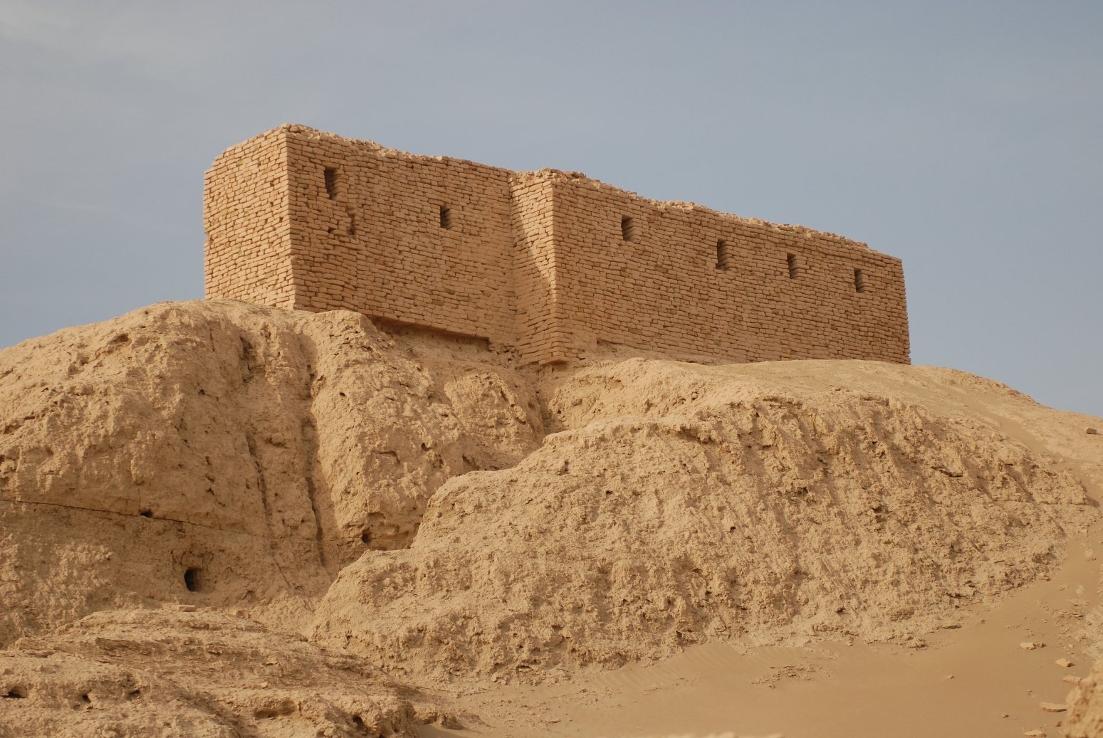
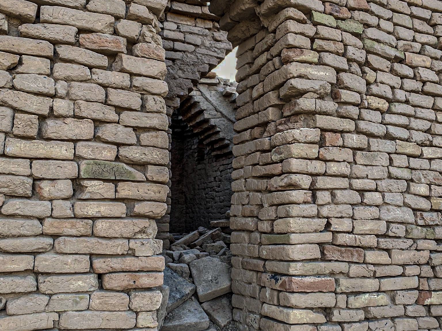
A Parthian fortress was built over the former Ekur and its ziggurat, probably during the second half of the first century AD. It incorporated massive walls, remodelled or filled temple courts, and a large northern courtyard bordered by four iwans, vaulted or roofed halls open on one side. The former ziggurat became an acropolis-like structure with a cruciform arrangement. The fortress remained in use until approximately AD 250.
Tablet Hill and residential areas
Tablet Hill, also called the Scribal Quarter, was a residential area south of the principal temple sector. Its buildings produced large quantities of literary, lexical, legal, administrative, and school tablets. Their domestic setting shows that scribal education took place in private houses rather than in a temple library.
Area TA covered approximately 20 by 40 metres and was served by a northeast to southwest street. Its houses were mainly small, irregular mud-brick residences, sometimes with water installations, central circulation spaces, or possible courtyards. Some stairways may have led only to roof terraces.
House I, approximately 50 square metres, was divided successively among the owner’s four sons, reorganized after shares were purchased, and eventually partly acquired by another family. House K was a courtyard house belonging to a wealthy family. Other courtyard houses included Houses D, C, and O. House C was arranged around two courtyards before being divided, while House F contained more than 1,400 school and literary tablets.
Houses in area TB included the large House J, approximately 20 by 30 metres, arranged around three courtyards. Its northwestern sector may have had an administrative function, while the southeastern sector may have been residential. Tablets from the building concern both institutional work and private transactions.
A bakery residence in area WB contained domestic remains and evidence that bread was baked outside the house in tannur-type ovens. Documents indicate that the baker supplied the city administration, the temple of Ninurta, and private customers.
First-millennium BC residences included a small house of approximately 90 square metres in area TA, arranged around a paved central courtyard and later enlarged at the expense of neighbouring buildings. Other structures included larger partially excavated houses and a building in area WC-2 with small rooms, a large paved courtyard, a well, and a possible chapel. The latter has been interpreted as a commercial space with shops around a courtyard.
Canals and archaeological objects
Canals were integral to Nippur’s layout. The Shatt en-Nil divided the two principal mounds, while other canals crossed the city, bounded parts of the walls, or supplied water. The shifting Euphrates and the failure or restoration of irrigation repeatedly affected the density and location of settlement. Later Sasanian occupation included major canals and extensive settlement, especially on the western side.
Archaeological finds include an early true arch, Early Dynastic bowls, brick stamps, cuneiform tablets, foundation deposits, statues or statue fragments associated with Ur-Nammu and Shulgi, an Indus Valley stamp seal, and a box containing fragments of Kassite glass votive axes. These objects illuminate temple foundations, ritual activity, administration, and Nippur’s long-distance connections. Early Islamic remains include a substantial settlement, a Jewish quarter, and numerous Aramaic incantation bowls, some bearing representations of demons and protective texts intended to guard against illness or supernatural harm.