Qaryat al-Faw: Capital of the Kingdom of Kinda
Site at a Glance
- Rating
- 4.3
- Popularity
- Low
- Country
- Saudi Arabia
- Primary era
- Classical
- External website
- Open
- Eras represented
- Classical
- Civilizations
- Unclassified
- Site type
- City
On this page19 sections
History
Qaryat al-Faw is an ancient city in Saudi Arabia that served as the capital of the Kingdom of Kinda. It emerged in the fourth century BC and flourished from the third century BC into the third century AD, with an urban tradition characteristic of pre-Islamic Arabia.
A city on the Arabian trade routes
The city stood where Wadi al-Dawasir meets the Tuwaiq Mountains, near the northwestern edge of the Empty Quarter. Its position placed it on the major route linking southern Arabia with the northeastern Arabian Peninsula. Caravans from Saba, Ma’in, Qataban, Hadramaut, and Himyar travelled through Najran and Qaryat al-Faw toward al-Aflaj, al-Yamamah, the Gulf, Mesopotamia, and the Levant.
This position made Qaryat al-Faw a commercial, religious, political, and cultural centre. Its economy also rested on agriculture and pastoralism. Residents cultivated date palms, grapevines, grains, and some aromatic plants, while raising camels, cattle, goats, sheep, gazelles, and ibex. The city remained prosperous for more than six centuries.
In antiquity the city was known as Qaryat Dhat Kahil, a name connected with Kahil, the principal deity worshipped by Kinda and Madh’hij. During its prosperous period it was also associated with the names “Red City” and “City of Gardens.” Kahil was a major deity of these peoples, while Shams, a solar deity, was associated with a temple and ritual activity at the city.
Political change and abandonment
Qaryat al-Faw was involved in the rivalries that shaped the Arabian Peninsula. The Namara inscription records an expedition led by Imru al-Qays ibn Amr toward Najran. During that campaign he reached Qaryat al-Faw and expelled the ruling Madh’hij tribe.
Himyar, a South Arabian kingdom, exercised political authority over the region during the first to third centuries AD. Kinda abandoned the city around AD 300, and Qaryat al-Faw was abandoned soon afterward. Its remains preserve evidence of a centre that connected southern Arabian kingdoms, interior communities, and regions farther east and north.
Rediscovery and archaeological work
Modern interest in the site began in the 1940s, when Saudi Aramco employees drew attention to its remains. Three company employees visited in 1952, followed by further studies by antiquities and museum specialists, King Saud University, and Saudi antiquities authorities.
Archaeological investigations began in the early 1970s and continued into the early 2000s. The Saudi archaeologist Abd al-Rahman al-Ansari directed work from 1971 to 1995. Excavations revealed the residential quarter, market area, temples, cemeteries, and other parts of the ancient city, with the results published in seven volumes.
A 2013 cooperation agreement between King Saud University and Saudi heritage authorities supported the expansion, development, and comprehensive conservation of the archaeological area, with the planned area reaching approximately 16 square kilometres. By 2014, the Saudi government had completely fenced the site to protect it from looting, and a major improvement and conservation programme had been authorised.
Surveys announced in 2022 combined aerial photography, drones, topographic survey, lidar, ground-penetrating radar, laser scanning, geophysical methods, intensive ground survey, and archaeological test probes. They identified additional religious, funerary, agricultural, hydraulic, and rock-art features. The same investigations identified a prehistoric human presence dating to the Neolithic period and more than 2,807 tombs classified into six groups representing different periods.
In 2024, Qaryat al-Faw was inscribed on the UNESCO World Heritage List as the Cultural Landscape of Al-Faw Archaeological Area. The cultural property was listed under criteria (ii) and (v) as a site of outstanding universal value.
Remains
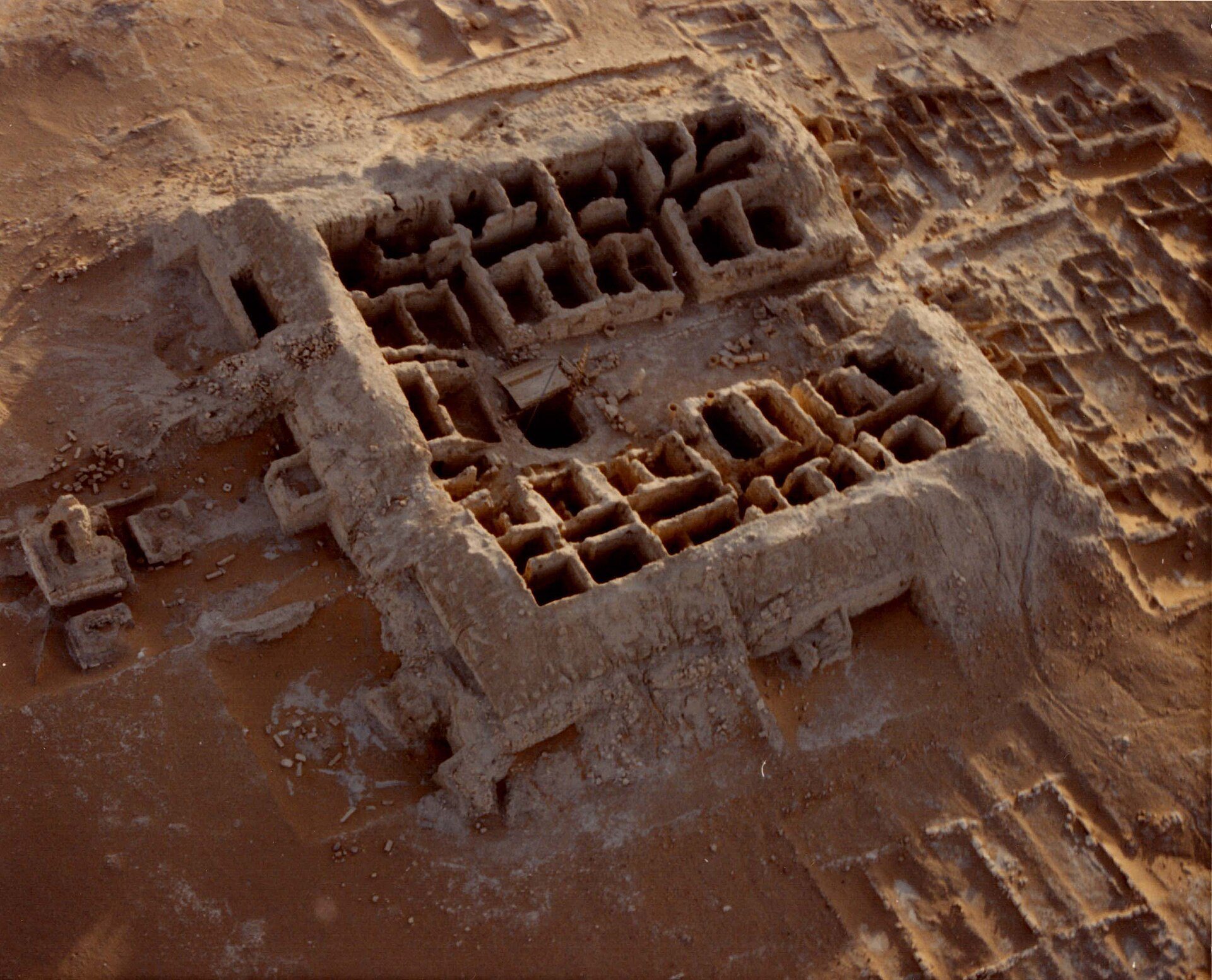
The archaeological area extends across a planned urban and agricultural landscape at the meeting of Wadi al-Dawasir and the Tuwaiq Mountains. Residential quarters, markets, streets, squares, temples, cemeteries, palaces, wells, irrigation installations, cultivated areas, and rock-art zones formed an interconnected settlement. Extensive walls surrounded the city, although Qaryat al-Faw was not a fortified settlement in the strict sense.
Urban quarters and water management
Market
The central market stood near the western edge of the valley between Tuwaiq Mountain and the eastern side of the residential area. A substantial wall made from three adjoining sections enclosed the market. The complex had three levels, seven towers, shops, rooms, and storage spaces, and was built from limestone blocks and mud brick. Erosion has buried almost an entire storey. Grain-storage facilities and baking ovens remain visible among the surviving remains.
Residential quarter
The residential quarter contained lanes and streets between houses, squares, separate housing units, wooden doors and roofs, and channels that carried clean water away from the houses. Some rooms measured approximately 10 metres long and 3 metres wide. Buildings followed carefully controlled straight lines and right angles, giving the quarter a deliberately planned layout.
Construction used square and rectangular mud bricks, while foundations and tombs employed dressed and polished stone. Interior walls were finished with plaster mixed with sand and ash. Local and imported wood served for doors, windows, and roofs, and rectangular or square towers reinforced the buildings.
Palace area
The palace area contained two buildings, each with two central stone columns supporting its roof. Benches ran along the walls, suggesting that the rooms may have served for reception or assembly. Numerous painted fragments were found in this part of the city.
Water and agriculture
Planned canals brought water into the city, where it was stored in wells, cisterns, and underground reservoirs. More than seventeen major wells were recorded. Later surveys identified hundreds of underground tanks near the agricultural areas, where floodwater was stored. The irrigation system supported fields in an exceptionally dry environment.
Temples and religious areas
Temple of Wadd
Five temples were associated with different periods and deities. The Temple of Wadd was a rectangular building of limestone ashlar, or regularly cut stone prepared for masonry, measuring approximately 30.75 by 25.20 metres. Corner and intermediate towers strengthened its structure. It stood in the central area near the palace and a fortified complex identified as a market.
Temple of Shams
The Temple of Shams included a mrzḥ, a ritual banqueting installation. Its painted decoration includes reclining banqueters, vine scrolls, winged figures, amphorae, chariots, Roman clothing, wreaths, fruits, and other imagery associated with Mediterranean and Egyptian visual traditions. The installation has been interpreted as a funerary banqueting space. A painted fragment bearing the inscription “zky,” probably a benediction meaning “pious” or “blessed” rather than a personal name, belonged to a larger decorative scheme in one of the temple’s rooms.
The paintings show human figures, camel drivers, and mythological subjects within cartouches, vines, and grape clusters. Some are probably dated to the first century AD. Their imagery combines naturalistic and perspective-based tendencies with more stylised symbolic forms. White, ochre, red, and black dominate the surviving palette, with occasional blue.
Mountain religious area
At Khushm Qaryah, on the rocky eastern edge of the site in the Tuwaiq Mountains, a religious area contained the remains of a stone-built temple, an offering table, and numerous devotional inscriptions. A separate inscription dedicated to Kahil was found at the Temple of Jabal Lahha. It names a donor from the Gerrhaean city and indicates links between Qaryat al-Faw and Gerrha, probably through trade and possibly through shared or tolerated religious practices.
Caravan buildings and cemeteries
Caravan stations
Four large buildings stood along the edge of the Tuwaiq Mountains. Some had corner towers, while their internal divisions and open courtyards suggest that they served as caravan stations or resting places. Their position at the edge of the city relates them to the movement of people and goods along the routes that supported Qaryat al-Faw.
Royal and elite cemetery
The royal and elite cemetery consisted of stone-built chambers surmounted by tombs or towers. Royal and noble burials extended along the eastern periphery, while the kings’ tomb stood separately to the northwest of the city. One monument was a small stepped, pyramid-shaped tomb identified as the tomb of King Muawiyah. Other tombs belonged to nobles and members of the elite.
Inscriptions, paintings, and objects
Inscriptions occur on mountain slopes, in the market, on artistic panels, in the residential area, on grave markers, on pottery, and on other archaeological materials. The scripts include South Arabian musnad, Sabaean, Minaean, and semi-Sabaean forms. The language reflects a mixture of northern and southern Arabian features.
The city has produced stone and metal sculptures, marble sculptures dating from approximately the second century BC, painted panels, pottery, woven linen, sheep wool and camel hair, silver coins, metal vessels, cooking pots, knives, needles, dagger sheaths, keys, and bracelets. Pottery ranges from coarse and fine wares to glazed vessels, and some pieces bear musnad inscriptions. Notable finds include the bronze female head known as the Lady of al-Faw, a statue of Heracles, a statue of the Thaj girl, and a bust of Artemis from the burial area.
Glass perfume vessels from the site date from the late first to early second century AD. They include a date-shaped mould-blown bottle 6.5 centimetres high and 3.5 centimetres in diameter; a 4.6-centimetre-high jar measuring 3.8 centimetres across and retaining one of two small ribbed dark-blue glass handles; a spherical bottle 5 centimetres high and 4.5 centimetres in diameter with marble-like floral-garland decoration; and a long-necked vessel 12.2 centimetres high and 5.9 centimetres in diameter.
Rock art and the wider landscape
Rock carvings and inscriptions cover parts of the Tuwaiq Mountain escarpment. Their subjects include hunting, travel, combat, and daily life. One group is associated with a man named Madhkar ibn Munam, who recorded his story through carvings on the rock. East of the city, a large jebel, or mountain, contains substantial caves and petroglyphs, images carved into rock surfaces.