Serpent Mound: A Prehistoric Effigy Mound in Ohio
Site at a Glance
- Rating
- 4.4
- Popularity
- Medium
- Country
- United States
- Primary era
- Medieval
- External website
- Open
- Eras represented
- Classical, Medieval
- Civilizations
- Unclassified
- Site type
- Religious
- Remains
- Sanctuary
On this page13 sections
History
Serpent Mound is a prehistoric effigy mound in Adams County, Ohio, United States, built on a plateau above Ohio Brush Creek. An effigy mound is an earthwork shaped as an animal, human figure, object, or other recognizable form. The mound is associated with the Serpent Mound crater, a geological structure formed by an ancient event estimated at roughly 250 to 330 million years ago. Its date and builders remain debated, with evidence pointing either to the Adena culture of the Early Woodland period or to the later Fort Ancient culture.
Early Woodland and Fort Ancient interpretations
Radiocarbon dating published in 2014 and supported by further analysis in 2019 placed construction at about 300 BCE and attributed the earthwork to the Adena culture, an Early Woodland tradition centered in the Ohio Valley. Other charcoal samples obtained during a 1996 investigation produced dates around 1070 CE, a result that supports construction by the Fort Ancient culture, which flourished in the Ohio Valley from approximately 1000 to 1750 CE.
The evidence has also been interpreted as indicating more than one phase. An earlier Adena earthwork may have been followed by Fort Ancient rebuilding or repair around 1100 CE. Archaeologist Brad Lepper challenged the Adena attribution, arguing that some dated material may have been organic sediment rather than charcoal and that the samples came from soil cores rather than an exposed sequence of layers. Lepper and his colleagues concluded that the strongest available evidence favored Fort Ancient construction, although the mound’s chronology and cultural affiliation remain unresolved.
In 1996, Robert V. Fletcher and Terry L. Cameron, working under Bradley T. Lepper, reopened a trench first excavated by Frederic Ward Putnam. Two charcoal samples from the trench produced dates of approximately 1070 CE. A third sample taken below the level associated with human alteration gave a date of approximately 2920 years before present. That result may indicate an earlier Adena-period phase or activity predating the mound’s principal construction.
Excavation and preservation
Ephraim G. Squier and Edwin Hamilton Davis conducted early surveys and published the first major description and map of Serpent Mound in 1848 in Ancient Monuments of the Mississippi Valley, a study commissioned by the Smithsonian Institution. Clinton Cowen surveyed and mapped the mound and its surroundings in 1901.
Late nineteenth-century archaeologists excavated Serpent Mound and nearby conical mounds. Frederic Ward Putnam worked at the site from 1886 for approximately four years, investigating burials and mound contents, recording his findings, and restoring the earthworks afterward. His investigations included nine intrusive burials, meaning burials inserted into an earlier mound, associated with an ash bed. He also excavated a conical mound containing a principal Adena-period burial.
Concern about the destruction of Ohio’s mounds through plowing and development led Putnam to purchase approximately 60 acres at the site in 1886, with financial support organized by Alice C. Fletcher and other Boston women. The property included Serpent Mound, three conical mounds, a village site, and a burial area. Ownership passed in 1900 to the Ohio State Archaeological and Historical Society, a predecessor of the Ohio History Connection, which assumed responsibility for management. The property became Ohio’s first state historic site. The Arc of Appalachia Preserve System managed it from 2009 until early 2021.
In 2011, archaeological work before utility-line installation examined parts of the previously excavated conical mound and an ashy soil horizon. Charcoal from the ash bed dated to approximately 1041–1211 CE. Burials in the conical mound were interpreted as belonging to both the Early Woodland and Fort Ancient periods, suggesting that the area was reused for ritual activity. The earthworks were restored after Putnam’s excavations, and a museum, observation tower, and walkway were later established for preservation and interpretation.
The United States Department of the Interior designated Serpent Mound a National Historic Landmark in 1966, the same year it was added to the National Register of Historic Places. A National Historic Landmark is a United States designation for a place judged to possess exceptional national historical importance. The mound was placed on the United States tentative World Heritage list in 2008. Vandalism in 2012 included people running and jumping on the mound and burying quartz in and around it. After a truck was driven over a nearby Adena burial mound in 2015, additional security cameras were installed.
Interpretations and meaning
The earthwork has been interpreted in several ways. Proposed explanations include a serpent connected with a Dhegihan Siouan origin story, a relationship to serpent symbolism in the Mississippian cultural world, and astronomical or cosmological purposes. These interpretations remain proposals rather than established explanations for the mound’s meaning.
Remains
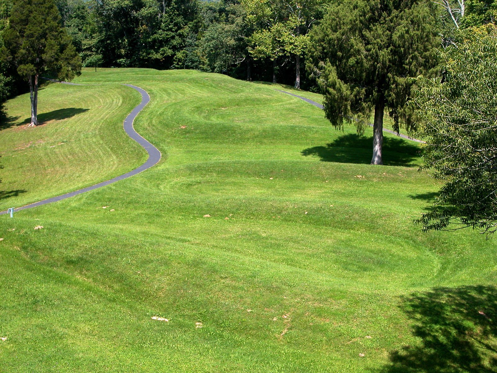
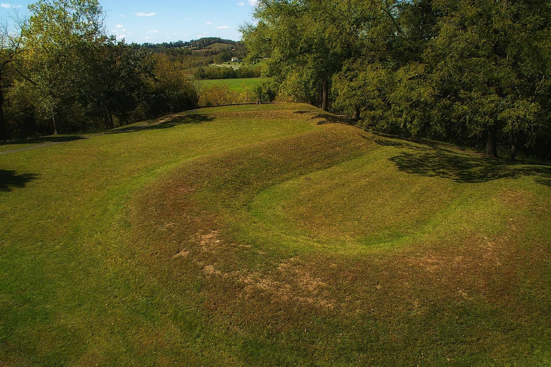
Serpent Mound is an approximately 1,348-foot (411-meter) earthwork that follows the contours of the plateau above Ohio Brush Creek. Its body winds back and forth for more than 800 feet (approximately 240 meters), forming seven coils before the tail ends in a triple coil. The mound is made mainly of yellowish clay and ash, with an outer reinforcing layer of rocks and soil. Its height ranges from about 9 inches (23 centimeters) to more than 3 feet (91 centimeters), while its width is approximately 22 to 24 feet (6.7–7.3 meters).
The serpent effigy
Head and oval feature
The eastern end forms an open-mouthed serpent head around an east-facing hollow oval measuring approximately 120 feet (37 meters) in length. Ephraim G. Squier and Edwin Hamilton Davis interpreted the oval as an egg that the serpent appears to be swallowing. The head-and-oval area has also been interpreted as aligned with the sunset at the summer solstice, although the astronomical purpose of the arrangement remains uncertain.
Coiled body and tail
The central body traces the contours of the bluff in a series of curves. Its seven coils continue into a tail that ends in a triple coil. The tail has been interpreted as aligned with the sunrise at the winter solstice. Other proposed alignments involving the curves, equinoxes, moonrises, and additional astronomical patterns remain uncertain because the lines of sight are short and imprecise.
Western triangular mound
The western end includes a triangular mound measuring approximately 31.6 feet (9.6 meters) along its base and long axis. It has been interpreted either as part of the serpent’s body or as a frog. Another interpretation identifies it as the remains of a platform. These differing readings reflect continuing uncertainty about the original form and purpose of this portion of the earthwork.
Nearby earthworks and archaeological material
Conical burial mound
One nearby conical mound excavated by Putnam was reconstructed after excavation and stands north of the site’s parking area. Its contents included a principal Adena-period burial, while later burials in the area were associated with both the Early Woodland and Fort Ancient periods. The property also contains or contained a village site and a burial area, placing the serpent effigy within a broader archaeological landscape.
Recovered objects
Excavations at the site recovered Hopewell-related pipes, points, and earspools, as well as Adena-related gorgets and points. These objects, together with the burials and ash deposits in nearby mounds, provide evidence for activity in more than one period around the serpent earthwork.
Geological setting
The plateau occupied by Serpent Mound forms part of a cryptoexplosion structure, a geological formation containing folded and faulted rocks. Explanations for its origin have included a meteorite or asteroid impact and an explosive event caused by gases rising from deep within the Earth. In 2003, geologists from Ohio and the University of Glasgow concluded that a meteorite impact formed the structure, based on analyses of rock samples.
The associated crater is approximately 8.7 miles (14 kilometers) in diameter. Erosion is believed to have removed its former topographic expression, leaving no clearly visible crater form at the surface. The mound’s observation tower, museum, and walkway belong to the modern preservation and interpretation of the earthwork rather than to its prehistoric construction.