Orongo: A Rapa Nui Ceremonial and Archaeological Site
Site at a Glance
- Rating
- 4.8
- Popularity
- Very Low
- Country
- Chile
- Primary era
- Early Modern
- Eras represented
- Early Modern
- Civilizations
- Polynesian, Rapa Nui
- Site type
- Religious
- Remains
- Sanctuary
On this page20 sections
History
Orongo is a ceremonial and archaeological site built by the Rapa Nui people on the southwestern rim of Rano Kau on Rapa Nui, the Polynesian name for Easter Island in Chile. Activity at the site dates from about AD 800 to 1810, with most evidence belonging to the fifteenth and sixteenth centuries, when Orongo reached its greatest ceremonial importance.
Origins and ceremonial development
Orongo’s exposed position above the Pacific and its views toward Motu Nui, Motu Iti, and Motu Kau Kau gave the site particular ritual importance. It was associated with Makemake, the Rapanui creator god and lord of the birds, and with fertility rites. The site’s religious traditions may also have developed from, or incorporated elements of, the wider Polynesian cult of Rongo, a deity connected with agricultural production, especially sweet potatoes, as well as sound, song, recitation, and listening.
The village itself is dated to the late sixteenth century. Earlier interpretations proposed that the birdman cult replaced ancestor worship and the construction of monumental moai, the stone statues associated with Rapa Nui ancestral traditions. More recent dating indicates that these religious systems probably coexisted for at least part of their history. Archaeological research also attributes the moai, Orongo’s petroglyphs, and the rongorongo tablets to the same population, rejecting older theories that separate “long-ear” and “short-ear” peoples built them.
The tangata manu competition
Orongo became the center of an annual competition associated with the tangata manu, or birdman, cult. Clan leaders gathered at the site with representatives called hopu. These men descended the cliffs, swam through strong currents to Motu Nui, and waited for the first egg of the sooty tern, or manutara. The representative who returned with an undamaged egg presented it to his clan leader. That leader received the title tangata manu and exercised political and religious authority for a year.
The ceremony involved processions, bodily painting, shaving, and a festival whose traditionally transmitted details include sexual and cannibalistic practices. The contest was extremely dangerous because of the cliffs, surf, currents, and sharks. The winning birdman was regarded as especially sacred and powerful, but faced restrictions that included isolation and a prohibition on touching food with his hands. The ceremony took place during the seabirds’ nesting season, and tradition places the last contest in 1862. After the cult ended, Orongo ceased to function as a ritual center and deteriorated.
Early visits and archaeological investigation
The missionary Eugène Eyraud probably became the first European to enter Orongo during his stays on Rapa Nui in 1864 and from 1866 to 1868. His successors, Hippolyte Roussel and Gaspar Zumbohm, recorded information about the birdman cult in letters. In 1868, the crew of the British ship Topaz removed the moai Hoa-haka-nana-ia from one of Orongo’s stone houses and carried it to England.
The first systematic investigations took place during the 1882 visit of the German gunboat Hyäne, commanded by Wilhelm Geiseler. Geiseler prepared detailed descriptions, records of finds, and a general plan. William Thomson of the USS Mohican photographed and documented the site during the ship’s visit from 18 to 31 December 1886. He also removed several petroglyphs, which are now held by the Smithsonian Institution.
Katherine Routledge conducted a scientifically organized investigation in 1914 and 1915. She produced a detailed plan and description of the houses and recorded oral traditions about the birdman ceremonies. The French-Belgian expedition of 1934 and 1935 catalogued the petroglyphs and developed a major reinterpretation of the birdman cult. Edwin Ferdon carried out stratigraphic excavation and radiocarbon dating during the Heyerdahl expedition of 1955 and 1956, followed by further work by William Mulloy in 1974. Heide-Margaret Esen-Baur published additional research in 1983.
Restoration and continuing protection
A restoration project sponsored by UNESCO began in 1974 under William Mulloy, with support from the Rapanui archaeologist Sonia Haoa Cardinali. The first part of the stone village was investigated and restored in 1974, the remainder was completed in 1976, and further investigations followed in 1985 and 1995.
Orongo forms part of Rapa Nui National Park and has World Heritage status. It was included in the World Monuments Watch in 1996 and again in 2000 because rainfall and visitor traffic caused soil erosion. Conservation planning subsequently addressed the site’s long-term management.
Remains
Orongo occupies a narrow, highly exposed cliff at the southwestern edge of the Rano Kau caldera, a broad volcanic depression formed by collapse or erosion around a former volcanic center. The Pacific side falls about 300 meters, while the opposite side descends roughly 200 meters toward Rano Kau’s freshwater lake and marsh. Within this restricted setting, a stone village, carved rocks, ceremonial platforms, settlement remains, and an interpreted observatory occupy the site.
Stone village
Houses and construction
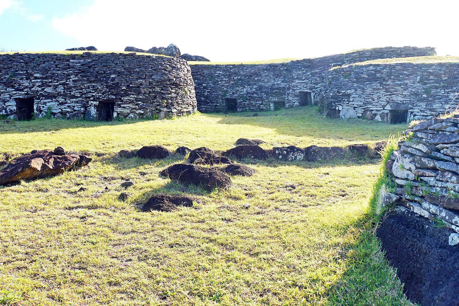
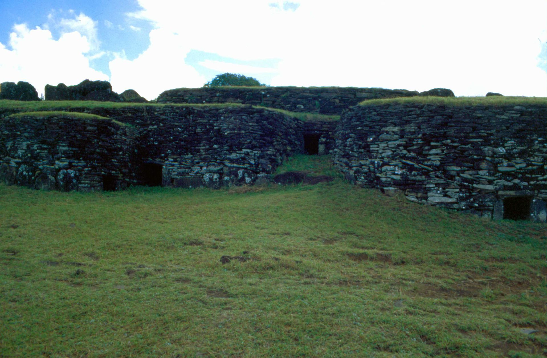
The village contains approximately fifty low, windowless stone houses, generally described as 52 well-preserved buildings. Most have elongated oval or boat-shaped plans and are partly sunk into the ground. Builders used naturally flat basalt slabs anchored in the earth and stacked without mortar. Double outer walls held earth and rubble, while corbelled roofs were formed by projecting upper stones inward and covering them with larger slabs, earth, and turf.
Most houses have a single tunnel-like entrance about 50 centimeters high, requiring entry by crawling. Two houses are circular but use the same general construction method. Interiors usually contain one room, with some having two rooms or a small annex. Interior lengths range from 6 to 16 meters, average width is about 2.5 meters, and height is about 1.4 meters. Recorded floor areas range from 2 square meters to 27.7 square meters.
Painted slabs
Some rear interior walls were lined with large upright stone slabs painted reddish brown, black, and white. Eleven painted motifs were identified, including ships, the ritual dance paddle Ao, a face possibly representing Makemake, vulvas, and birdmen. Many of the painted slabs were removed or damaged by visitors. The surviving slabs were later removed for conservation and are held in the museum at Hanga Roa.
Courtyard and House R-42
A roughly paved courtyard lies at the center of the village. Houses border it in a semicircle, and some entrances stand directly beside one another. House R-42 was recorded with four entrances grouped together and a statue serving as a central post. Decorated or sculpted doorframes were later removed and are now held in collections in Europe and the Americas.
House R-13 and Hoa-haka-nana-ia
House R-13 contained the basalt moai Hoa-haka-nana-ia, which is about 2.4 meters high and weighs approximately four tonnes. The statue was originally buried to the navel and painted red and white, although only limited traces of the paint remain. Reliefs of birdmen, Ao dance paddles, and vulvas cover its back. Hoa-haka-nana-ia is now held by the British Museum in London.
Ovens and storage features
Stone-lined earth ovens were found outside several entrances. Some of these features have also been interpreted as storage pits, indicating that food preparation and storage formed part of activity around the houses.
Petroglyphs and ceremonial platforms
Rock carvings
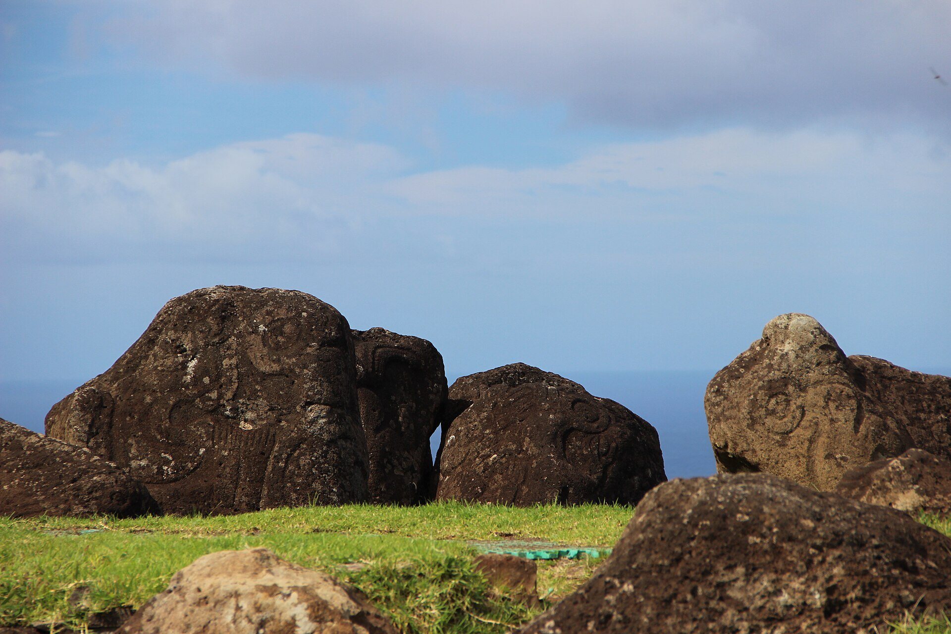
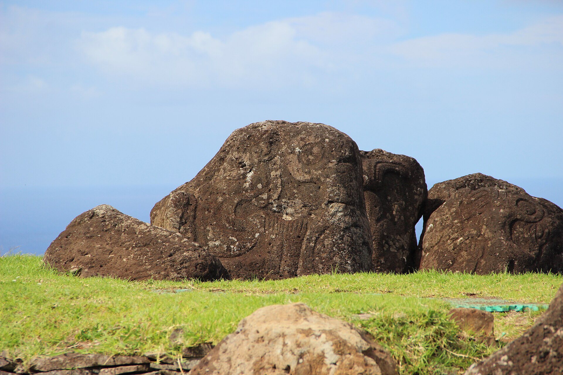
Petroglyphs, images or designs carved, pecked, or incised into rock, occur throughout Orongo. The 1934 and 1935 expedition recorded 53 boulders bearing more than 200 figures. Common motifs include birdmen shown as human and frigate-bird hybrids, birds probably including terns, mask-like faces probably representing Makemake, vulvas, ships, and Ao dance paddles. Fish, whales, possible seals, turtles, and unidentified designs also occur, especially near the entrance.
The carvings range from highly accomplished reliefs to simple, roughly incised figures. Birdman images are quantitatively dominant, but the overall distribution has no clearly understood system. Their ritual purpose remains uncertain, although they may have commemorated clans that supplied successive birdmen.
Ahu
Two ahu, or ceremonial stone platforms, survive in the northeastern part of the site. They were built roughly from mostly unworked stones and now survive mainly as shapeless accumulations. Their position forms part of the wider ceremonial landscape alongside the houses and carved rocks.
Settlement and observation features
Paenga houses and domestic remains
Excavations revealed foundations of Paenga houses, a type of stone-built elite dwelling, together with additional Paenga houses, stone round-house foundations, and brick-lined earth ovens. These remains occur in a setting associated with permanent settlement and domestic or elite activity, showing that Orongo’s physical use extended beyond ceremonies.
Interpreted observatory
In a more peripheral area, Edwin Ferdon excavated a stone arrangement interpreted as an observatory. Worked stones with drilled holes could receive shadow sticks for determining the sun’s position at the solstices and equinoxes. The area also contained numerous petroglyphs and a small stone statue consisting of a head without a body.
Recovered objects
Excavations inside the houses recovered everyday objects including bone needles, tattooing tools, obsidian blades, and animal bones. Several houses contained oval stone objects known as ngaru’a, decorated with numerous vulva motifs. Their function and meaning remain unknown.
Condition and conservation
The surviving houses are generally in good condition, while painted slabs have been removed or have deteriorated. Sections of the petroglyph area have been restricted because of collapse and erosion risks. Marine erosion, strong winds, rainfall, and soil erosion caused or intensified by foot traffic continue to threaten the site’s stonework, carvings, and exposed ground surfaces.