Msoura Stone Circle: A Middle Neolithic Megalithic Enclosure in Morocco
Site at a Glance
- Rating
- 4.1
- Popularity
- Low
- Country
- Morocco
- Primary era
- Stone Age
- Eras represented
- Stone Age, Classical
- Civilizations
- Unclassified
- Site type
- Burial
- Remains
- Burial Mound
On this page9 sections
History
Msoura Stone Circle is a megalithic enclosure near Chouahed village, about 15 kilometers southeast of Asilah in northern Morocco. Local communities probably established the monument during the Middle Neolithic, on or near an earlier Epipalaeolithic habitation, and later added a large burial mound. As the only known monument of this type in Morocco, Msoura has played an important role in interpretations of prehistoric and ancient society in northwestern Africa.
Neolithic enclosure and later burial
The enclosure’s date remains difficult to establish because its isolated setting and uncertain archaeological associations provide limited chronological evidence. Architectural parallels with megalithic enclosures in the Iberian Peninsula support a Middle Neolithic date, however. The builders used local sandstone to create an ellipse of standing stones, probably before the central mound was constructed.
A circular tumulus, or artificial burial mound, was added at a later period, probably during the fourth or third century BC. An amphora from the mound has been used to support this dating. The burial may have belonged to a high-status Mauri individual, perhaps a king. Mauri was the name associated with the people of ancient Mauretania, a kingdom and later Roman provincial region in northwestern Africa. The monument has consequently been interpreted as evidence for the emergence of a powerful confederation or kingdom in the region.
Antaeus and the tradition of a royal tomb
Ancient and later traditions connected the mound with Antaeus, a giant from Greek mythology traditionally said to be the son of Gaia and Poseidon. In the myth, Heracles killed Antaeus by lifting him away from the earth, and the figure became strongly associated with North Africa. The identification of Msoura with his tomb is uncertain and may have been encouraged by the monument’s proximity to the Roman road between Tingis and Banasa and Volubilis.
The monument is probably not directly named in the surviving ancient texts, although a passage in Plutarch’s account of Quintus Sertorius may refer to it indirectly. Sertorius was a Roman general and political leader active in the first century BC, while Plutarch was a Greek-Roman biographer whose Parallel Lives preserves the story. According to the tradition, local inhabitants showed Sertorius the tomb during his visit to Mauretania in 82 BC. He allegedly opened it, saw a gigantic body, performed a sacrifice, and reburied it. The story is legendary, but it has encouraged interpretations of the burial as that of an important tribal war chief or ruler and as evidence for ancestor veneration in ancient North Africa.
Early descriptions and archaeological damage
The earliest known written reference to Msoura is associated with a Portuguese raid from Arcilla in 1471. Portuguese soldiers reportedly rested beneath the large standing stone later called Pedra Alta. Arthur de Capell Brooke visited the site in 1830 or 1831, counted about 90 standing stones, proposed that the mound was artificial, and compared the monument with megalithic structures in Britain. Émilien Renou mentioned Msoura in 1846, Gustave-Marie Bleicher described the tumulus in detail in 1875, and Henry Koehler examined the surrounding monoliths in 1932.
Koehler also reported abundant flint-working debris near the monument. César Luis de Montalban began excavations in 1935 and 1936, but his imprisonment during the Spanish Civil War interrupted the work, and the results were never published. The excavation substantially damaged the site. It left two deep cross-shaped trenches and an X-shaped scar in the mound, while later disturbance removed facing stones, overturned enclosure stones, and contributed to erosion of the tumulus.
Twentieth-century interpretation and protection
Miquel Tarradell investigated or reported on Msoura during the 1950s and rejected interpretations that connected it with the builders of Stonehenge or similar European monuments. Gabriel Camps later argued that local people constructed the enclosure and mound as the burial place of a Mauri chief or king, using knowledge available in the region.
A Franco-Moroccan-American team carried out the first complete survey between 1970 and 1976, although the survey included numerous inaccuracies. Influenced by the work of Alexander Thom, the team proposed that the enclosure had an astronomical purpose. Franco-Moroccan excavations followed in 1979 and 1980 and again in 1998. An astronomical function for the enclosure and the nearby stone groups remains possible, but it has not been demonstrated.
The Tangier branch of the Historical Monuments Inspectorate protects the site. On 27 January 2025, the Moroccan Ministry of Culture added Msoura to the national heritage list, giving the monument legal protection against alteration or destruction.
Remains
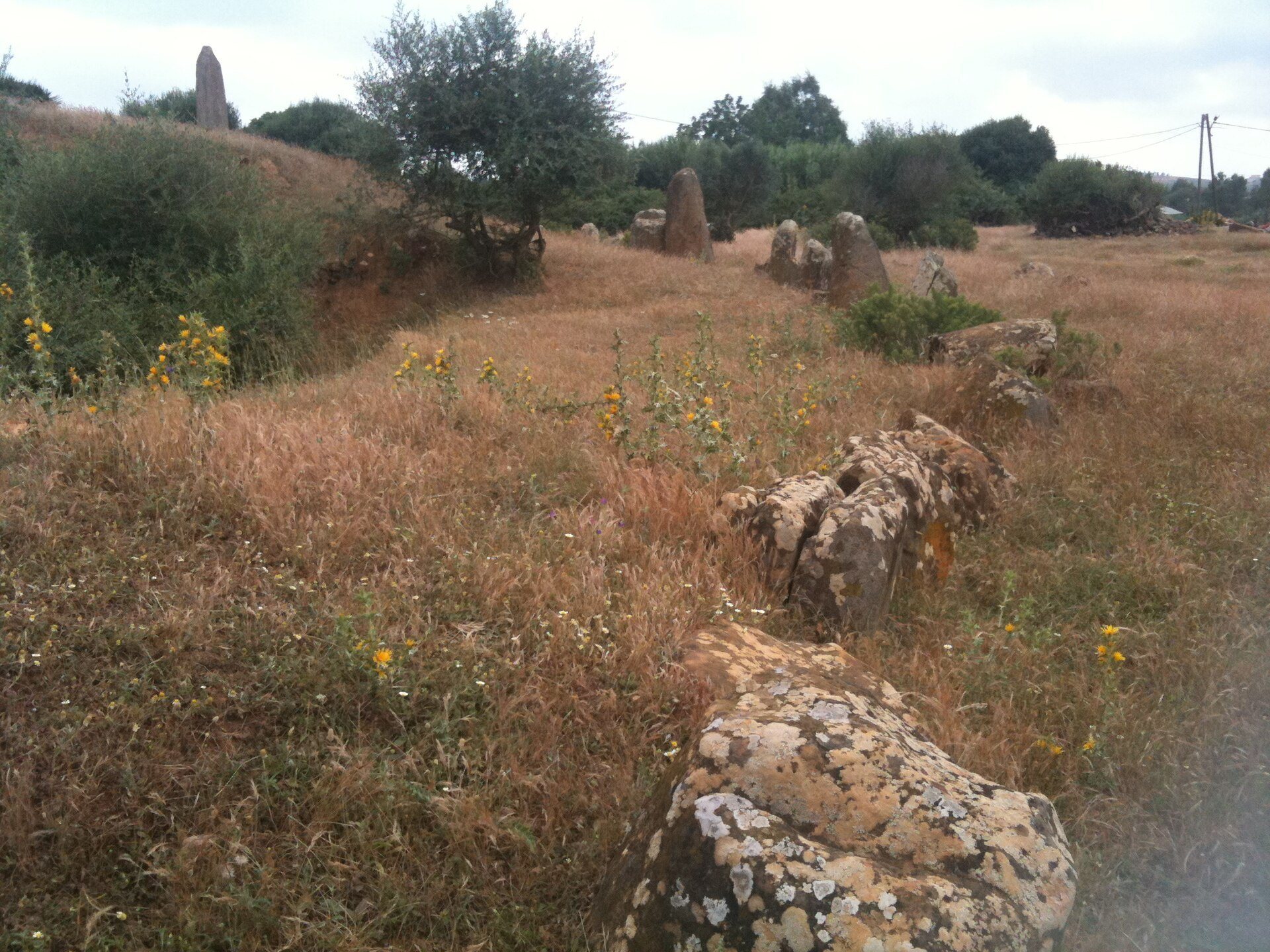
Msoura stands at an elevation of about 118 meters on a sandstone outcrop. Its principal monument consists of an east-west oriented elliptical enclosure surrounding a central circular tumulus. The upright and fallen stones are made from soft sandstone taken from an exposed bed about 150 meters south of the site. Smaller groups of stones extend to the north and northeast.
The main stone enclosure
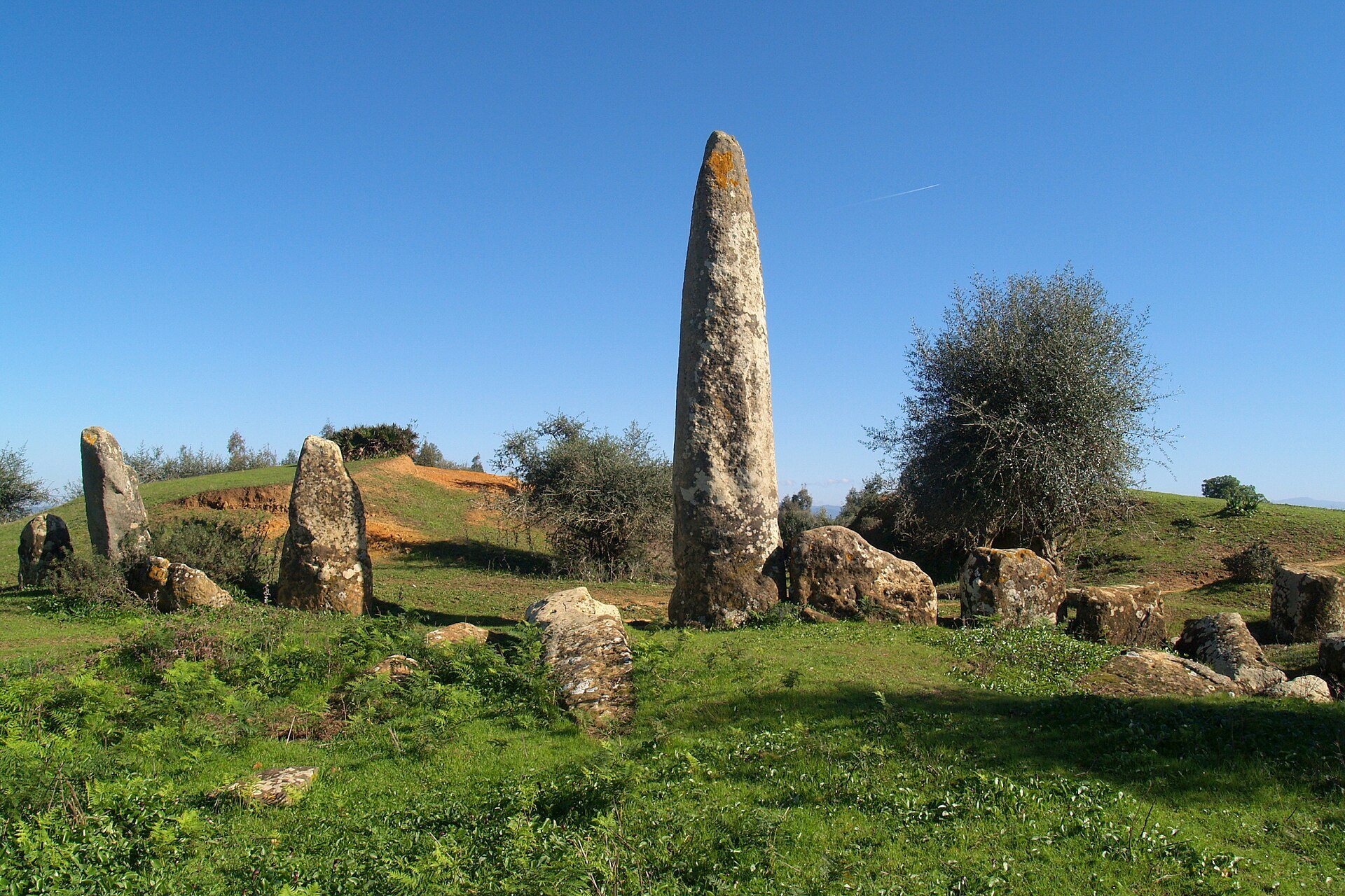
The enclosure measures approximately 56 by 59 meters and contains roughly 170 monoliths, with an average height of about 1.5 meters. Five stones are substantially larger than the rest. The tallest, El Uted, meaning “the peg,” reaches approximately 5.34 meters. The stones have three principal forms: rectangular blocks between 0.50 and 0.80 meters thick, sub-quadrangular blocks between 0.70 and 1 meter thick, and round or oval blocks measuring 1 to 2 meters across.
Stone workers extracted the blocks in a rough state and partly shaped them by repeated blows with stone tools. Many were later truncated, apparently with a metal chisel. About 80 retain their original upper sections, which may be pointed, flat, or rounded. The surviving stones are upright or fallen, and later damage includes overturned monoliths and the removal of some facing stones.
The central burial mound
The central tumulus is about 55 meters in diameter and reaches roughly 6 meters in height at its center. Its outer facing wall is built from dressed limestone blocks arranged in five courses and rises approximately 1.5 meters. The surviving body of the mound consists of loose small sandstone blocks, clay, and sand, with numerous worked flints dating to the Epipalaeolithic visible within it.
Montalban’s excavation cut two cross-shaped trenches, each about 5 to 6 meters wide, and stripped the entire southeastern quarter of the mound. The work exposed parts of its internal arrangement. In the northern portion, a blocking structure runs approximately parallel to the outer facing. The center contains an alignment of edge-set slabs, three tabular structures, and a circular depression.
The depression may mark a central stone burial chamber, possibly a cist, which is a stone-built chamber, or a dolmen, a megalithic chamber formed from upright stones and large slabs. Montalban may have discovered the chamber, but its elements were later dispersed. One trench may also have sought a hypothetical entrance passage, whose outer entrance could have been indicated by El Uted.
Satellite stone groups
Three groups of stones lie north and northeast of the main monument within a radius of about 100 meters. Every surviving stone in these groups has fallen. The stones are made from the same sandstone as those in the principal enclosure, and their surviving arrangements form straight segments approximately 15 meters long, oriented east-west and north-south.
One nearby group is described as a smaller ring containing 16 monoliths. Some satellite stones may originally have formed internal parts of the tumulus and may have been removed during earlier excavations before being piled around the monument. Their arrangement as subsidiary circles has not been demonstrated.
The later tumulus would have prevented an astronomical sighting system linking the main enclosure with the exterior stones. An arrangement serving this purpose before construction of the mound remains possible, but the evidence does not establish it.