Ek’ Balam: A Maya Urban and Political Center in Yucatán
Site at a Glance
- Rating
- 4.7
- Popularity
- High
- Country
- Mexico
- Primary era
- Medieval
- External website
- Open
- Eras represented
- Classical, Medieval, Early Modern
- Civilizations
- Maya, Spanish
- Site type
- City
On this page23 sections
History
Ek’ Balam is a Maya urban and political center in Yucatán, Mexico, occupied from approximately 300 BC through the Postclassic and the period of the Spanish conquest. The city developed across the Preclassic, Classic, and Postclassic periods, when Maya kingdoms and monumental cities flourished across southern Mexico and Central America. Ek’ Balam became the capital of a regional polity called Talol and reached its greatest prominence during the Late Classic, especially between about AD 770 and 840.
Early settlement and the Talol dynasty
Archaeological evidence places the beginning of occupation at around 300 BC, although settlement may have begun as early as the Middle Preclassic period. This early occupation is distinct from later foundation traditions preserved in a late-sixteenth-century Relación Geográfica, a Spanish colonial inquiry that gathered information about local places, buildings, and traditions.
The Relación Geográfica identified the regional polity as Talol and named either Ek’ Balam or Coch Cal Balam as its founder. According to the tradition, he came from the east with many people, ruled for 40 years, and was murdered. His successor, Heblaychac, later brought that dynasty to an end. These accounts preserve local memories about the city’s origins, but they describe a foundation tradition rather than the earlier archaeological evidence for settlement.
Ek’ Balam expanded from the Late Preclassic onward. Its influence extended through northern Yucatán, where it developed a distinctive ceramic tradition known as the Talol ceramic complex or style. This pottery tradition spread through the surrounding region and reflects the city’s wider political and cultural influence.
Late Classic expansion
The city reached its political and architectural peak during the Late Classic. Ukit Kan Lek Tok’ was the principal ruler associated with this period of expansion. He ruled from about AD 770 into the early ninth century and commissioned major monumental works, including the Acropolis or parts of it. His enthronement, associated with AD 770, appears in the Mural of the 96 Glyphs.
Ukit Kan Lek Tok’s accession was attended by Chak Jutuuw Chan Ek’, the northern Kalo’mte’, a high-ranking royal title associated with regional or supraregional authority, and ruler of Emal. Chak Jutuuw Chan Ek’ had arrived from Emal earlier that year. The event places Ek’ Balam within a network of political relationships extending beyond its immediate territory.
Late Classic construction transformed the central area into a protected concentration of plazas, temples, elite buildings, and ceremonial spaces. Monumental defensive works enclosed the ancient center, while the wider settlement extended across nearly 12 square kilometres. The walls and the dense arrangement of major structures indicate that the enclosed area served as an elite and ceremonial core.
Decline and Postclassic transformation
Ek’ Balam’s regional influence weakened after the Late Classic. Prosperity had declined by about AD 1000, and the city’s broader decline may have begun around AD 1200. During the Postclassic, the population reportedly fell to about one-tenth of its maximum as increasing parts of the city became vacant. The region later came under the control of the Cupul, an aristocratic family whose name was also applied to the jurisdiction.
In the early eleventh century, a foreign intrusion, possibly involving the Itza, subdued Ek’ Balam and Yaxuna. Before the rise of Chichen Itza, Ek’ Balam had been one of the leading Maya powers in northern Yucatán. Nomon Cupul was among the last rulers of the later regional order before the Spanish reconquest.
Colonial survival and archaeological investigation
Ek’ Balam remained inhabited after the Spanish conquest of Yucatán. The settlement was briefly depopulated in 1579, after which Juan Cupul was appointed governor of a small community there. An open chapel from this colonial period survives within the archaeological zone, providing physical evidence of the site’s continued use after the end of Maya political independence.
Désiré Charnay visited Ek’ Balam in 1882 and made photographs of the site. Systematic survey and measurement began in 1984, followed by archaeological excavations initiated by George Bey and William Ringle in 1993. From 1997, Leticia Vargas de la Peña and Víctor R. Castillo Borges of Mexico’s National Institute of Anthropology and History directed large-scale excavations and reconstructions, including work on the Acropolis. Excavations on Structure 1 began when it was still largely covered by a mound.
Modern investigations have made Ek’ Balam an important source for understanding northern Classic Maya urbanism, particularly because many other major northern Maya sites are less well preserved. Inscriptions and wall paintings have been studied through archaeological and epigraphic projects, while a mural-recording project of the National Autonomous University of Mexico has documented the site’s pre-Columbian paintings since 1990. The name Ek’ Balam is commonly translated as “Black Jaguar.” An interpretation of Ek’ as “star,” supported by star-like paintings in Structure 1 and associated with the city’s emblem glyph, also gives the name the meaning “Star Jaguar.”
Remains
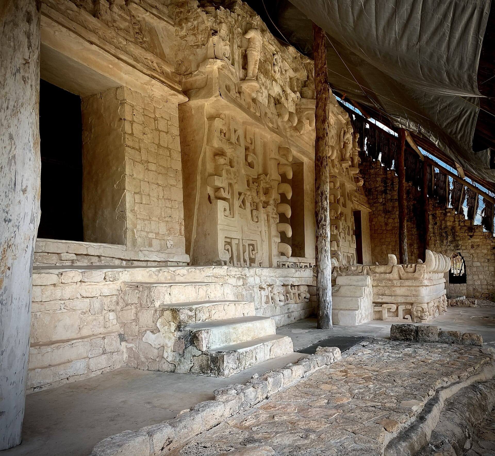
The central zone covers approximately 1 to 1.25 square kilometres and is enclosed by two principal concentric walls, with additional smaller and internal barriers. The wider settlement covers nearly 12 square kilometres. Raised roads, plazas, monumental platforms, temples, elite residences, and ceremonial buildings are concentrated within the enclosed center. Many façades used plaster, stucco relief, and painted decoration, including forms associated with the Chenes architectural tradition, whose characteristic serpent- or monster-mouth portals are especially prominent at the Acropolis.
Walls, roads, and central approaches
The inner wall encloses about 9.55 hectares. Its surviving carved stone is approximately 2 metres high and 3 metres wide, and it was covered with plaster and finished more elaborately than the less substantial outer defensive wall. The defensive system also used steep sinkholes, where walls terminate at apparently impassable drops. A narrow fourth wall crosses the Great Plaza. Built from poorly laid rubble and less than 1 metre wide, it has been interpreted as a final defensive barrier, although the speed and circumstances of the city’s abandonment remain uncertain.
Several passages cross the outer wall, and five sacbes, raised Maya roads linking buildings and settlements, begin there. The longer roads run approximately toward the cardinal directions, while the shortest runs toward the south-southwest. Together, the central roads form a four-part directional system often interpreted as a set of sacred routes. Their lines lead toward the central ceremonial area, the Oval Palace, and the ballcourt.
Monumental arch
The main entrance includes a monumental Maya arch supported on four legs over the road into the city. It may have served a ceremonial purpose. The road continues from the arch toward the central ceremonial zone and the principal buildings of the enclosed center.
North Plaza and the Acropolis
Three very large buildings stand around the North Plaza. Structures 2 and 3 lie at right angles to the Acropolis and extend approximately 80 and 110 metres respectively. Both still rise more than 20 metres above the surrounding ground, although only isolated sections of their walls appear above the rubble and both remain unexcavated.
Structures 2 and 3
Structure 2 occupies the western corner of the Acropolis and includes a temple at one corner. Structure 3 forms the eastern corner and is an unexcavated platform bordering the main plaza. Their scale and position define the northern ceremonial group around the Acropolis.
The Acropolis
Structure 1, commonly called the Acropolis and identified in inscriptions as Sac Xoc Naj, or “White House of Learning,” occupies the north side of the site. It is the largest surviving Maya building in northern Yucatán. The structure measures approximately 150 metres in length, 55 to 70 metres in width, and 29 to 31 metres in height. Its highest surviving part was originally about 6 metres higher.
The Acropolis has six levels and at least 72 rooms. Its principal façade faces south, where a central staircase, interrupted repeatedly by the building’s terraces, rises toward the largely lost uppermost level. The lowest level stands on a basal platform and contains two corresponding rows of five rooms. The façade was covered with low reliefs on its facing stones, although only a small proportion of the relief blocks remained in place and the full façade has not been reconstructed.
Two rooms at the middle height of the central staircase have entrances emphasized by stucco relief, probably representing a serpent-mouth portal. These entrances have been reconstructed. Directly before them is a stucco serpent face whose tongue extends down several steps. An inscription on the tongue concerns the dedication of the building and staircase by Ukit Kan Lek Tok’, who commissioned the work.
The second level contains a long chain of rooms extending around three sides of the building. Narrow stairways lead through interruptions in this range to a roof level with two courtyards. Each courtyard occupies the full depth of the building and about one-third of its width, although only the western courtyard has been fully excavated.
Western courtyard and upper levels
The western courtyard is bordered on its western and northern sides by rooms preserved only to their foundations. A broad northern staircase rises toward a heavily destroyed upper level. Within the courtyard is a circular, stone-lined depression about 2 metres deep whose function remains unknown.
A staircase from the courtyard crosses the western façades of the third and fourth levels and reaches the highest part of the building. The third level rests on a platform forming the base of the central section. Rooms occupy three sides, and the two rooms nearest the central staircase each have a portico formed by two thick masonry columns. Another staircase, now preserved mainly on the eastern side, led from this level to the fourth.
Serpent-mouth portal and upper temple
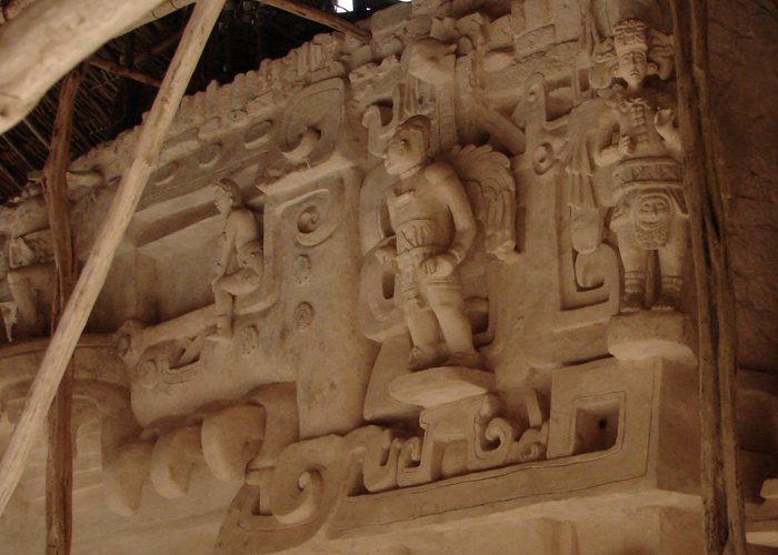
The fourth level is dominated by a large serpent-mouth entrance in the Chenes style. Its stucco relief projects from the façade, and its figures are rendered unusually in three dimensions. Some of the surviving figures are presented in a more human or genre-like manner rather than as purely supernatural beings. The façade projects slightly from the rest of the building and is separated from it by a narrow gap, giving it the appearance of an independent structure.
The fifth level survives only in fragments and contained rooms with portico entrances formed by thick masonry columns. The sixth level remains mainly as an extension of the central staircase and probably consisted of a single room that functioned as a temple.
Tomb of Ukit Kan Lek Tok’
The tomb of Ukit Kan Lek Tok’ lies behind the serpent-mouth portal on the fourth level, in the area called El Trono, or “The Throne.” Its plaster remains unusually well preserved. Ukit’s remains were found inside, together with a miniature representation of him showing a severely deformed face. Osteological analysis attributed the deformation to several deep dental infections, which reduced the height of the right side of the upper jaw and may have fractured the lower jaw.
Painted texts and imagery
Rooms in the Acropolis contain painted texts and scenes. The Mural of the 96 Glyphs is a major work of Maya calligraphy comparable to the Tablet of the 96 Glyphs at Palenque. Another mural depicts a mythological scene involving a hunted deer and has been interpreted as a possible reference to the origin of death. Paintings on vault capstones show a lightning deity, while other murals include naturalistic figures of deities, mythical beings, humans, and animals.
Southern court and ceremonial buildings
The southern court contains buildings from several periods and connects several distinct forms of ceremonial architecture. These include structures aligned with raised roads, a circular-sided palace, paired buildings, a ballcourt, and a later platform with a small temple.
Structure 18
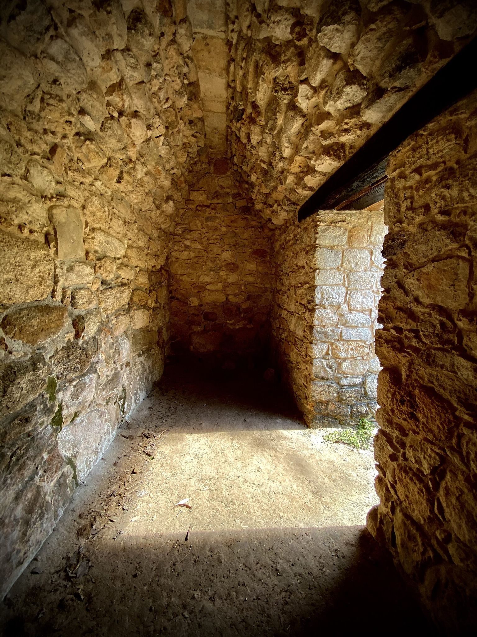
Structure 18 stands at the urban end of Sacbe 2 on a three-level platform. Four thick rectangular wall sections enclose a small interior space that opens through narrow and broad entrances on all four sides. A ramp aligned with the road leads to the broad entrances, while stairways lead to the narrow ones. The originally vaulted interior has been reconstructed.
Oval Palace
Structure 16, known as the Oval Palace, combines a long rectangular building with a circular section built in six steps. The rectangular portion contains rows of rooms on two levels. The circular portion forms a substantial pyramid platform topped by a small, single-room temple reached by a broad northern staircase. Burial remains have been associated with the building, whose alignment has been interpreted as related to cosmological ceremonies.
The Twins
Structure 17, called the Twins, consists of two similar buildings on a high platform approached by stairways from the east. Each building has two narrow entrances leading into an interior room, and a narrow passage at ground level separates the pair. Their façades were covered with stucco decoration.
Ballcourt
The ballcourt runs approximately north to south between two older buildings, partly covering their rooms and façades. It has unusually broad sloping rebound surfaces and a low vertical boundary wall. Stairways from the eastern and western sides of the earlier buildings led to small temples at roof level.
The earlier buildings have façades resembling the Puuc style, another Maya architectural tradition known for arranged masonry, columns, friezes, and geometric or diagonal decoration. The ballcourt was completed around AD 841, placing it within the period of Ek’ Balam’s Late Classic prominence.
Structure 10
Structure 10 is a large platform in the southeast of the southern court. Its western side has a very broad recessed staircase that has been only partly reconstructed. A particularly small, low temple stands on the platform, recalling small temples of Yucatán’s east coast. The platform base dates to the Late Classic and was built over by later generations.
Inscriptions, sculpture, and dynastic imagery
Carved Stela 1 was erected around AD 840. It depicts a ruler holding the raised scepter of K’awiil, a Maya deity associated with royal authority, lightning, and dynastic power. Ukit Kan Lek Tok’ appears above the ruler, seated on a celestial throne as ancestor and dynastic founder. The lower figure has been identified as K’inich Junpik Tok’ K’uh…nal, described as the last king of Ek’ Balam, although another interpretation identifies him only as a ruler, possibly Ukit Jol Ahkul.
The Acropolis frieze and portals combine open-jawed serpent or monster imagery, a seated ruler, and winged warrior figures. This elaborate stucco decoration is especially associated with the Chenes style and has parallels at sites in Campeche. Other identified features at Ek’ Balam include a steam bath, while Structures 7 and 12 are known by number without their individual forms and functions being described here.
Colonial chapel
An open chapel survives from the colonial period, when Ek’ Balam remained inhabited after the Spanish conquest. Its presence within the ancient center adds a later layer to the site’s architectural history, linking the remains of the Maya city with the small settlement that continued there under colonial administration.