Hulbuk: Medieval Capital of Khuttal in Tajikistan
Site at a Glance
- Rating
- 4.5
- Popularity
- Very Low
- Country
- Tajikistan
- Primary era
- Medieval
- Eras represented
- Classical, Medieval
- Civilizations
- Samanid
- Site type
- City
On this page21 sections
History
Hulbuk is a medieval city in Tajikistan, at the site of present-day Kurbon Shahid, also known as Pingan, in Vose District. It developed within the historical province of Khuttal and served as its capital from the ninth century to the beginning of the eleventh century, when the region lay under Samanid overlordship. The city was regarded as one of the largest in Central Asia and remained Khuttal’s provincial capital after the Ghaznavid conquest of 1024.
Early Khuttal and Islamic Conquest
Khuttal had belonged to the sphere of the Hephthalites, a late antique power active across parts of Central Asia and northern South Asia, during the sixth century. Archaeological work at Hulbuk places occupation of the citadel mound as early as the Bronze Age and identifies construction phases reaching back to the fifth or sixth century. Some of the earliest decorative traditions at the citadel are associated with Hephthalite and sixth- or seventh-century Turkic phases.
Umayyad forces conquered Khuttal, including Hulbuk, in 726, after earlier campaigns north of the Oxus River. Local rulers continued to exercise authority for a time, but the ruler based at Hulbuk was removed in 750 or 751. Pottery with a greenish metallic glaze from palace rooms indicates that Muslim rulers had taken over the complex by the middle of the eighth century.
Banijurid and Samanid Rule
From the ninth to the tenth century, Khuttal was controlled by the Banijurids, a ruling family probably of Iranian origin. They were generally vassals of the Samanids, an Iranian Muslim dynasty that ruled much of Transoxiana and Khurasan during the ninth and tenth centuries. The Banijurids nevertheless retained unusual autonomy, including the right to issue their own coins.
The first Banijurid palace at Hulbuk was probably destroyed by fire during the political conflict involving Chaghaniyan and the Banijurids. Around 948, the Samanid ruler Nuh ibn Nasr probably ordered its destruction after a revolt. A layer of fire, together with associated ceramics and coins, places the event no later than the middle of the tenth century and probably within the three decades before 930. The Banijurid family appears to have survived this upheaval and continued into the first quarter of the eleventh century.
Ghaznavid and Seljuk Conflict
Sultan Mahmud of Ghazni conquered Khuttal in 1024. The Ghaznavids were a Persianate Muslim dynasty that controlled large parts of eastern Iran, Afghanistan, and Central Asia during the tenth and eleventh centuries. Hulbuk continued as the provincial capital, and a sister of Mahmud was married to its governor, suggesting that the Banijurids retained a special position under the new regime.
Khuttal also served the Ghaznavids as a buffer against the northern Qarakhanids, a Turkic Muslim dynasty that ruled parts of Central Asia from the tenth to the early thirteenth century. In 1064, a local emir of Khuttal rebelled against the Seljuk ruler Alp Arslan. The Seljuks, a major Turkic Muslim dynasty of the eleventh and twelfth centuries, besieged Hulbuk and killed the emir. The Qarakhanid ruler Böritigin then defeated the forces of Khuttal, Saghaniyan, and Wakhsh. Attacks between 1064 and 1068 destroyed the citadel.
Abandonment and Historical Setting
The outer districts may have remained inhabited for a period after the citadel’s destruction, but Hulbuk was abandoned in the twelfth century. The silting or burial of mountain-fed water channels may have contributed to the abandonment. In the later twelfth century, Khuttal probably belonged to the Ghurids, although a coin dated 1199 to 1200 has also been associated with Qarakhanid control.
Khuttal lay north of the Oxus, principally between the Vakhsh and Panj rivers. Hulbuk was not directly on a major trade route, but older roads connected it with Balkh and Tirmidh and indirectly with Bukhara, Merv, Khurasan, Darvaz, Badakhshan, and China. Its political role therefore rested on its position as the capital of Khuttal and as a fortified administrative centre within a contested Central Asian frontier.
Archaeological Investigation and Preservation
Archaeological research began with test excavations in 1953 by Boris A. Litvinsky and Elena Davidovich. A Tajik-Russian team led by Erkinoj Guliamova worked in the citadel through 1978, and Guliamova continued research until 1991. Vladimir Bazhutin later prepared plans of the complex and graphic reconstructions of its architectural decoration.
Excavations resumed from 2003 to 2006 under Yusuf Yakubov of the Institute of History, Ethnography, and Archaeology of the Tajik Academy of Sciences. Investigations in the citadel continued until 2009, followed by study of the surrounding lower city by Pierre Siméon. Stratigraphic work between 2006 and 2010 revised the interpretation of the stucco and identified three previously unrecognized early decorative styles.
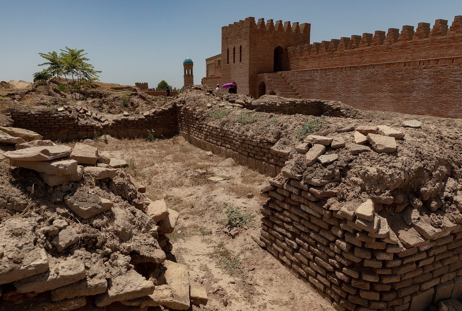
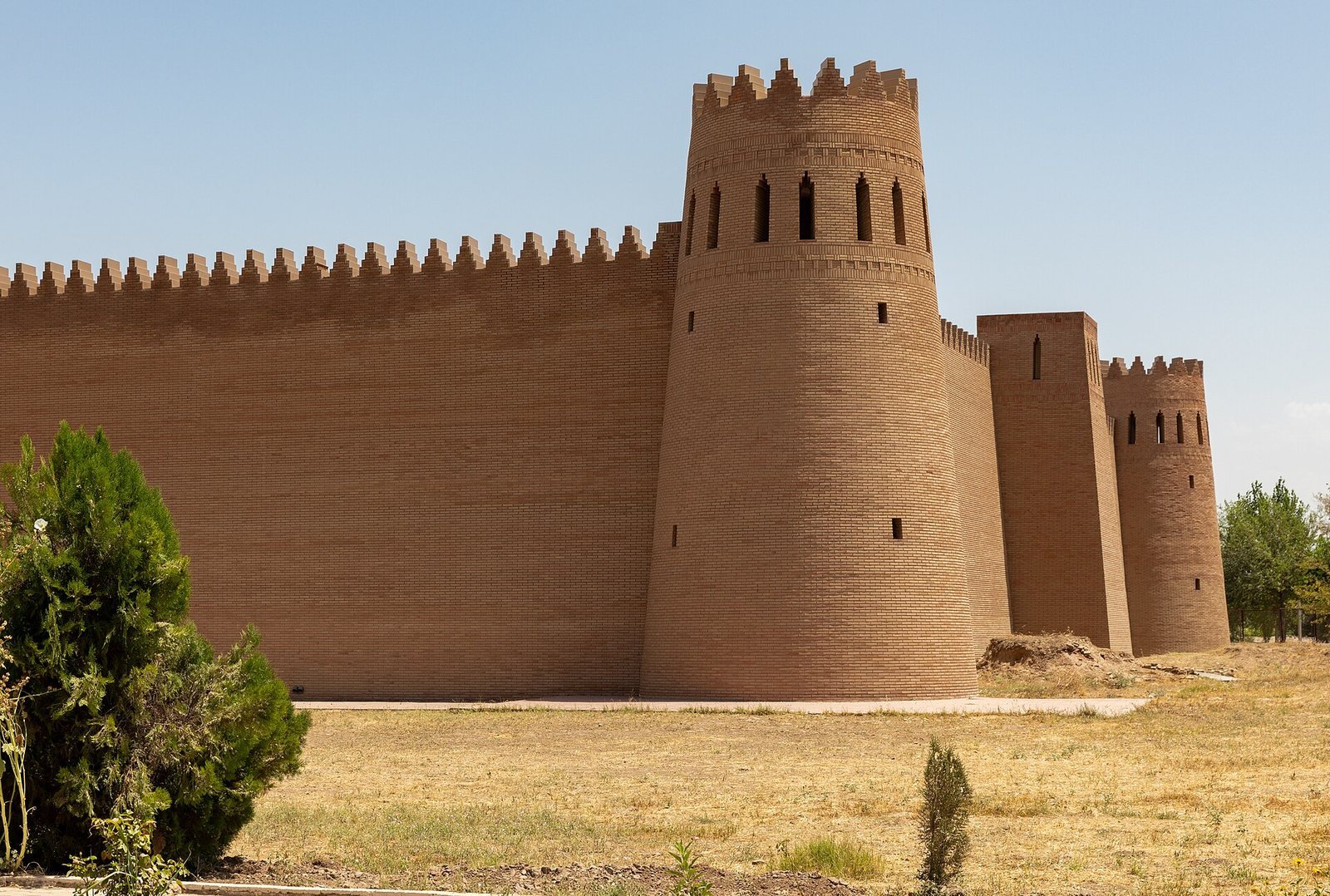
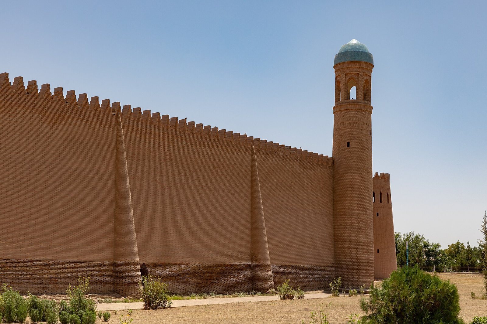
Since 2004, and more extensively since 2005, the largely vanished enclosure wall of the citadel has been reconstructed to convey the monument’s former scale rather than reproduce the original wall exactly. The eastern section was rebuilt without systematic prior investigation of its foundations and without preserving surviving original wall remains. A museum opposite the citadel opened in 2013, while finds were also transferred to the Archaeological Museum in Dushanbe and the Hermitage in Saint Petersburg. Hulbuk was placed on Tajikistan’s tentative UNESCO World Heritage list in 1999 and became part of the World Heritage property “Cultural Heritage Sites of Ancient Khuttal” in 2025.
Remains
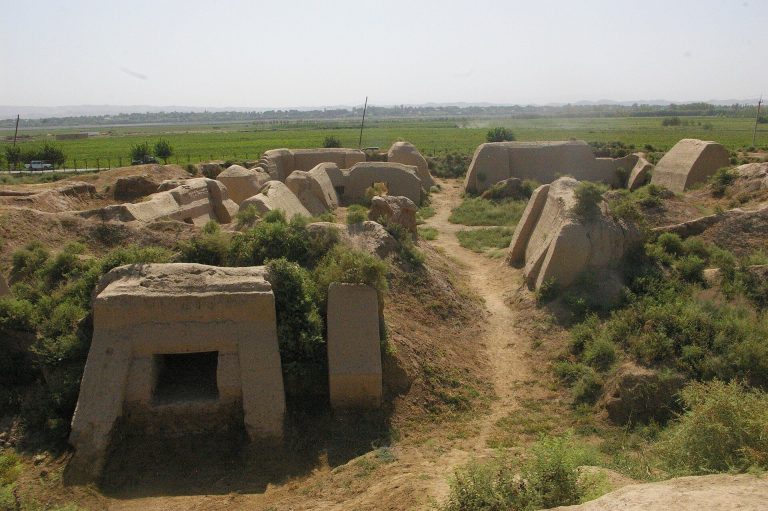
The archaeological settlement covers approximately 70 hectares, although much of it lies beneath modern buildings. The medieval city may have extended across as much as 280 hectares. Its urban arrangement consisted of a citadel, an inner residential city, and outer residential districts, with the inner city extending eastward toward the Kizilsu River. The citadel forms a roughly rectangular, north-south-oriented enclosure about 150 to 170 metres long and 50 to 60 metres wide. A large, nearly square central court divides its lower northern section from the higher southern section.
Citadel Enclosure and Entrance
Walls and Defensive Features
The southern third of the citadel rises about 15 metres above the surrounding ground, while the northern part rises about 10 metres. The walls were built of mud brick and coated with mud plaster. Later repairs used rammed earth, or pachsa, made by compacting clay mixed with straw. Most visible remains belong to the early eleventh-century rebuilding.
Excavations between 1985 and 1989 exposed 71 metres of the western enclosure wall, preserved between 0.8 and 3 metres high. Two semicircular buttresses south of the portal stand about 10 metres apart and taper upward. Round bastions measuring 4 to 6 metres across reinforced the four corners. Fallen material included stucco friezes with animal figures and inscriptions in foliated Kufic, an angular form of early Islamic Arabic calligraphy.
Western Portal
A monumental portal occupies the centre of the western wall. It is about 13 metres high and 8.5 metres wide and belongs to a later building phase, while the earliest citadel entrance was on the narrow northern side. A reconstruction drawing shows two flights of three steps separated by a landing. Flanking columns supported a tall pointed arch.
The rectangular field around the portal carries a diagonal swastika pattern, while its frame contains the Quranic Throne Verse in Kufic script. The reconstructed arch is higher than the version shown in Bazhutin’s drawing. About 20 metres in front of the portal, a two-metre-wide bank of rammed earth and mud brick was traced for 12 metres. It may have protected the entrance or formed part of the palace belonging to the first construction phase.
Palace Complexes
First Palace
The first palace stood approximately from 800 to 950. It was a square building about 35 metres on each side, with round towers at all four corners. A brick-paved court occupied the centre and was surrounded by 19 rooms in Bazhutin’s plan. The entrance passed through a gate room in the middle of the northern side.
Brick ornamental mouldings and stucco up to 10 centimetres thick decorated the building. Colonnades extended in front of rooms on all four sides, their roofs supported by wooden columns. The plan broadly followed that of the Umayyad governor’s palace known as Dar al-Imara at Afrasiab. The palace was probably destroyed by fire around 948, and its ruins later formed the platform for a new building.
Second Palace
The second palace was built over the burned first palace and remained in use from the 970s into the 1060s, undergoing repeated alterations. Its rooms opened onto a shared north-south corridor about 30 metres long and 3.75 metres wide. A second floor level, 20 to 45 centimetres above the first, indicates two construction phases.
From the southern side of the central court, the corridor continued past four rooms on each side, which may have served residential and ceremonial purposes. At its southern end stood a square building with walls 2 to 2.5 metres thick. The corridor probably had a barrel-vaulted roof, while the other rooms had flat roofs supported by pillars. Stucco covered the walls, and painted decoration survived on an iwan, a large roofed hall open on one side.
The palace had underfloor heating formed by clay tubes through which hot air or steam circulated. Water from a spring about 12 kilometres away was carried to a cistern and distributed through pipes. A waste opening in the western side of the floor led through a pipe outside the building, where servants removed the refuse. The arrangement around a central court and the small mosque have architectural parallels with the Ghaznavid complex at Lashkari Bazar in southern Afghanistan.
Palace Mosque
The palace mosque measures 15 by 15 metres and was entered from the east through a doorway in an iwan. Its lower stucco panels, each about 1 by 2 metres, display stylized plants and animals, especially goats, cats, and parrots. Bead mouldings and inscription bands framed the panels. Above them are circular floral forms within rectangular interlaced geometric patterns.
Three arcades divided the upper wall, each containing three ornamental pointed-arch panels about 0.8 metres wide and 1.5 metres high. Slender columns between the arches had capitals shaped as animals, including a surviving example with broad-faced wild cats. Animal imagery, like the swastika above the portal, preserves elements of pre-Islamic artistic traditions.
The mosque underwent two building phases. In the earlier phase, four central square pillars, each about one metre thick, divided the room into nine sections, with reconstructed girdle arches probably supporting domes. During the later rebuilding, ten pillars arranged in a central square supported a differently constructed roof, possibly timber with a central dome. A minaret foundation was found southwest of the mosque.
The building’s precise function remains uncertain. Its elaborate decoration suggests that it may have served not only as a private prayer room for the rulers of Khuttal but also as a princely reception hall. Early Islamic wall paintings from the eighth to the thirteenth century are known from only a small number of sites in Central Asia and the Iranian plateau, including Hulbuk, Nishapur, Lashkari Bazar, and possibly Rey.
Residential Quarters and Painted Rooms
Northern Residential Quarter
The northern residential quarter contained at least four buildings, each organized around a courtyard with an iwan. Three faced a large hexagonal water basin. The central courtyard was circular and paved with fired brick. Clay pipes supplied water, while cross-shaped basins were set into the floors. Mud-brick walls between 1 and 2 metres thick were covered with clay plaster, and floors were paved with square fired bricks.
A large room in the southwest corner preserved fragments of a wall painting showing a young soldier in orange and red clothing against a blue-and-white background. He holds a black staff in his raised right hand. Thirty-one silver coins were recovered from one room. The buildings appear to have been constructed together, and their walls and floors indicate carefully made and luxurious interiors.
Western Courtyard and Small Rooms
Five rooms excavated on the western side of the citadel in 1982 and 1983 belonged to a common courtyard with an iwan. Paintings on the southern wall show a veiled seated woman playing a long-necked lute. Above her are inscription bands in several forms of Kufic, painted white and yellow with black outlines against a blue-green ground.
About 70 very small rooms, most approximately 1.5 by 1.5 metres, have been associated with the harem. Nearby hearths surrounded by circular seating have been interpreted as possible fire-cult installations connected with Zoroastrian practice. Zoroastrianism is an ancient Iranian religion in which fire has an important ritual role, but the function of these installations remains uncertain.
Burial Areas and Urban Installations
Burial Structures
Graves lay about 300 metres east of the citadel, with two further burial sites approximately one kilometre to the west. The eastern complex, found during construction of a village school, included a building with walls about one metre thick and an area of 13.5 by 8 metres. Two burial chambers contained several graves, each with a semicircular mihrab, a prayer niche, oriented southwest toward the qibla, the direction of the Kaaba in Mecca.
The eastern structure’s walls survived to about one metre high and comprised 10 to 15 courses of fired brick. The upper walls were probably mud brick, and the rooms were covered with perishable materials. Western burial structures retained fired-brick corbelled vaults. One entrance used bricks laid lengthwise, meeting at right angles in the arch to create a herringbone pattern.
Workshops and Services
The wider settlement contained a pottery kiln area, a glass workshop, a brickworks, a bathhouse, and a mausoleum. Urban buildings used fired brick and mud brick, with plastered walls and floors paved with fired-brick or terracotta panels. Water and drainage systems included clay pipes, brick channels, cisterns, and refuse pits, some reaching six metres deep.
Several heating arrangements have been identified. The most common placed interlaced ceramic pipes beneath the floors, each pipe measuring up to 50 centimetres long and 10 to 15 centimetres in diameter, allowing heated air to circulate. Other systems used floor depressions 30 to 50 centimetres deep and no more than one metre wide, or large vessels filled with charcoal.
Objects and Material Culture
Ceramics from the two palaces differ markedly. Monochrome and polychrome lustre-glazed pottery, probably imported from southern Basra, occurred in the layers of the first palace. Epigraphic pottery made in Samarqand and Nishapur from the mid-ninth to the eleventh century carried Arabic proverbs and blessings. Polychrome painted pottery from the second palace was produced regionally, and a kiln in the city area may have manufactured it.
Glass finds include bottles, plates, bracelets, and two pressed-glass vessels decorated with animals. One, about 48 centimetres in diameter, depicts galloping horses. The other measures 10.5 centimetres across and 5 centimetres high and bears a fabulous animal on its underside. Steatite finds include cooking pots and a large rectangular incense burner with a handle. A bronze incense burner shaped like a lynx was found northeast of the citadel, and its hinged neck opens from the body. Bronze tongs point to connections with Khurasan.
The excavations also recovered 20 complete and eight fragmentary ivory chess pieces, along with three small lion figurines. The lion served as a protective symbol among the Samanids. More than 5,000 archaeological artefacts were found across the complex, adding material evidence for the courtly, domestic, religious, and productive activities that took place at Hulbuk.