Les Mousseaux Tumulus: A Neolithic Megalithic Monument in France


Site at a Glance
- Rating
- 4.3
- Popularity
- Low
- Country
- France
- Primary era
- Stone Age
- External website
- Open
- Eras represented
- Stone Age
- Civilizations
- Unclassified
- Site type
- Burial
- Remains
- Burial Mound
On this page7 sections
History
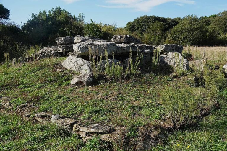
Les Mousseaux Tumulus is a Neolithic megalithic burial monument in France, located on the hill above the Noëveillard coastal area at Pornic. Built around 3500 BC, it belongs to the Loire dolmens, a regional class of megalithic tombs dating broadly to the fifth or fourth millennium BC, and reflects the Chasséen cultural tradition of Neolithic western Europe.
Early descriptions and nineteenth-century excavations
The monument was reportedly used as a hiding place by Abbé Galipaud, the parish priest of Pornic, between 1793 and 1796. In 1825, P. Grelier described the site as a human-made mound containing two cavities that he called “caves.” Charpentier partially cleared both spaces in 1837, recovering pottery fragments, animal bones, and a sharply edged triangular limestone axe about 20 centimetres long.
François Verger, an inspector in France’s Historic Monuments administration, continued the excavation in 1839. His finds included more ceramic fragments and animal bones, as well as a gouge and a polished serpentine axe. Jules Gailhabaud later described the monument in his 1845 work Monuments anciens et modernes, in a chapter concerning tumuli, or burial mounds.
Modern research and restoration
Jean L’Helgouach and Henri Poulain excavated Les Mousseaux Tumulus from 1975 to 1977. Pottery recovered in front of the facade walls, including bowls, bottles, and cups, was assigned to the Chasséen period and is displayed at the Dobrée Museum in Nantes. The excavations also produced flakes created during the working of flint and quartzite. L’Helgouach restored the tumulus during the 1970s. The monument was classified as a Historic Monument in 1889 and again in 2006.
Remains
The surviving monument is a stone cairn, a mound made mainly of stones that covers burial structures. It occupies a trapezoidal area measuring approximately 18 by 14 metres and now rises 1.90 metres high. Its original covering of stone and earth would have brought the mound to about 5 metres. Three trapezoidal enclosures organize the cairn around two transepted tombs, megalithic burial monuments whose side chambers branch from a central passage to create a cross-like plan. Both tombs face southeast, toward the winter-solstice sunrise, and their entrances are 4.70 metres apart. At the winter solstice, sunlight enters the southeastern entrance at precisely 9:00 a.m. Sandstone blocks from the Pays de Retz or Bourgneuf Bay form the tombs, while locally collected mica schist makes up the cairn.
Transepted tombs
Tomb A
Tomb A occupies the southern part of the cairn and has a symmetrical plan resembling a Lorraine cross. A covered passage leads to a quadrangular terminal chamber measuring 7.5 square metres. Two lateral chambers branch from opposite sides of the passage, with areas of 3 and 3.45 square metres. Its arrangement expresses the characteristic cross-shaped design of a transepted tomb.
Tomb B
Tomb B has an asymmetrical plan shaped like the letter F because it contains one lateral chamber rather than two. Its terminal chamber covers 5 square metres. The irregular arrangement is attributed to a technical constraint: two symmetrical side chambers would have left a large unused area at the centre of the tumulus and increased the cairn’s total area in proportion.