Yam Fortress: A Medieval Frontier Fortress in Kingisepp, Russia


Site at a Glance
- Rating
- 4.3
- Popularity
- Low
- Country
- Russia
- Primary era
- Early Modern
- Eras represented
- Medieval, Early Modern
- Civilizations
- Novgorod Republic, Russian, Swedish
- Site type
- Military
- Remains
- Fort
On this page13 sections
History
Yam Fortress is a medieval stone fortress in Kingisepp, Russia, founded in 1384 by the Novgorod Republic to protect its western frontier. Built near a presumed road station and a crossing of the Luga River, it guarded routes linking Novgorod with Europe. The surrounding settlement became known as Yamgorod, while later Swedish usage established the name Yamburg.
Foundation under Novgorod
The fortress was completed in only 33 days. Its construction drew on the wider territory of Novgorod and was directed by the boyar Ivan Fyodorovich, assisted by five district commanders, other boyars, and townspeople. The settlement was connected by road with Koporye, allowing reserve troops to reach the fortress quickly. Russian semi-military settlers were established nearby, and some townspeople were relocated under favorable terms. These arrangements helped Yamgorod develop around the frontier stronghold.
Yam first faced Swedish pressure in 1395, when its garrison, commanded by Prince Konstantin, defeated a Swedish attack. Livonian knights plundered villages around the fortress in 1397 but did not assault the walls.
Wars with Livonia and reconstruction
During the Novgorod-Livonian War, Livonian forces burned the settlement and destroyed its pier in 1443. In the autumn of 1444, they besieged Yam, but defenders commanded by the Suzdal prince Vasily Yuryevich, who was serving Novgorod, repelled the attack. Artillery fire destroyed a large medieval cannon used by the besiegers. A further Livonian assault in 1447 lasted 13 days. Novgorodian reinforcements arrived with artillery, and the Livonian army withdrew after suffering heavy losses.
The attacks badly damaged the fortress and exposed the limits of its defenses against firearms. In 1449, Archbishop Euthymius II of Novgorod ordered the old fortress dismantled and replaced on the same site with a larger stone stronghold. After the Novgorod Republic was absorbed into the expanding Grand Duchy of Moscow in 1478, Yam was repaired because it remained a frontier fortress, while Yamgorod received wooden defenses. The fortress was modernized during the 1490s.
In 1492, Ivan III ordered the construction of Ivangorod on the road to Livonia. Once that fortress had been built, Yam lost much of its military importance. By the beginning of the sixteenth century, however, Yamgorod had become a major trading center on the Luga River and in the surrounding area. A record from 1500 associated the town with 67 villages and 393 households.
Swedish rule and the bastion fortress
Swedish forces captured Yam on 28 September 1581 during the Livonian War. Russia recovered it after a three-day siege in 1590, and the Treaty of Tyavzino confirmed Russian possession on 25 May 1595. Sweden captured the fortress again in 1612, during the Time of Troubles, a period of dynastic crisis, political instability, and foreign intervention in Russia. Under the Treaty of Stolbovo in 1617, Yam and its surrounding territory passed to Sweden.
Russian usage continued to favor the name Yamgorod, while the Swedes called the town Yamburg. A Holstein embassy described Yamburg in 1633 as a medium-sized fortress with eight towers and high stone walls. Russian forces entered Yam during the Russo-Swedish War in 1658 and captured much of it, but Swedish defenders held the fortified inner citadel, or detinets, and repelled the attacks. The Russians withdrew because they lacked heavy siege artillery.
Erik Dahlbergh inspected Yam in 1681 and found it in poor condition, although he judged its construction to be of high quality. In 1682, most of the fortress, apart from the detinets, was blown up with 40 barrels of gunpowder. A new bastion fortress was begun on the site but remained unfinished when the Great Northern War began.
Return to Russia and decline as a military site
Yamburg surrendered to Peter I’s forces without a battle in 1700, but Russian troops abandoned it after their defeat at Narva. On 13 May 1703, a detachment commanded by Major General Nikolay Verden began bombarding the fortress. The garrison capitulated honorably the following day. Its soldiers were permitted to withdraw to Narva, while those who wished to remain could stay.
Peter I ordered the bastion fortress completed between 15 May and the autumn of 1703 under Field Marshal Boris Sheremetev. It was not rebuilt in stone because the capture of Narva and Dorpat had moved Russia’s frontier westward. Yam was retained mainly for a small garrison that could resist a possible Swedish amphibious attack, and its defenses held 53 guns of different calibers.
During the second quarter of the eighteenth century, the fortress was disarmed after the Russian military administration abandoned its system of fixed defensive positions. Military services continued to use the site, including its storage facilities, but the old detinets deteriorated through lack of maintenance. In 1760, Catherine II made Yamburg a town and ordered its extensive replanning. Architect Antonio Rinaldi reused part of the detinets walls for Catherine Cathedral in 1762. In 1781, Catherine II ordered the remaining detinets dismantled because of its dilapidated condition. The abandoned bastions were partly taken apart late in the eighteenth century to provide material for a calico factory.
Parkland and archaeological investigation
Troops stationed in the town created a park on the former fortress grounds in the mid-nineteenth century. The Irkutsk 93rd Infantry Regiment began the work, the Dvina 91st Infantry Regiment continued it after 1883, and the Tsaritsyn 146th Infantry Regiment completed it after 1893. Until the Russian Revolution, the park was called the Garden of the 146th Tsaritsyn Regiment.
Construction of a Commercial School disturbed the southern part of the fortress in 1909. The discovery of remains belonging to the southern tower led the builders to move the building farther north, away from the Luga River. In 1926, construction of the bridge across the Luga largely destroyed the surviving remains of the southwestern tower and contributed to the loss of much of the stone defenses.
Anatoly Kirpichnikov directed the first large-scale archaeological investigation in 1971. His expedition opened nine excavations covering 960 square meters and confirmed the accuracy of Swedish fortress plans made in 1680 and preserved in Stockholm’s Royal Military Archive. The work also established evidence for the destruction of the fortress’s southern part during the eighteenth century. The archaeological site received state protection in 1974 and is a federally significant cultural-heritage site of Russia.
Excavations in 2008 examined the seventeenth-century bastion fortress. A water pipe was found at the bottom of the filled northern moat, along with a sluice connecting the moat to a pond formed from the former eastern moat. Some excavated artifacts were transferred to the Kingisepp Local History Museum. In 2017, Rosterminalugol assumed responsibility for maintaining the park. The pond was drained and cleaned in 2019, its sediment was removed, and it was refilled with water from the Luga. A purification system with a fountain was later installed, and young carp and crucian carp were released into it.
The former fortress grounds are now known as the Summer Garden. During the Soviet period, the park was called the Garden of Working People, while local usage also called it the Dark Garden. A Soviet cinema and dance area was destroyed by fire and never restored. A monument to World War II partisans was installed in the southeastern part of the park in 1958.
Name and historical identity
The origin of the name Yam is uncertain. One interpretation connects it with yam, a Mongol-derived term for the postal relay system and the roadside stations used in Rus. Another associates it with the Finnic-Ugric people known as the Yem or Yam. Erich Kleinenberg proposed that German sources once used the name Nienslot, meaning “New Castle” or “New Town,” for Yam before the name was transferred to Ivangorod. After the Swedish takeover, Yamgorod and Yamburg became established in Russian and Swedish usage respectively.
Remains
Yam Fortress occupied a high, steep bank on the outside of a bend in the Luga River. The river protected the western side, while moats enclosed the northern, eastern, and southern sides. The site’s surviving earthworks and masonry are now distributed through the Summer Garden, where ditches still mark the northern and southern edges and an elongated pond marks the eastern side. The pond drains into the Luga through the northern moat.
Medieval fortress and inner citadel
Main fortress
The original fortress had a trapezoidal plan, with its long, slightly concave side facing the river. Its limestone walls were approximately 4.5 meters thick. Four round towers stood at the corners, while square towers in the middle of the western, northern, and eastern walls enabled defenders to direct interlocking fire along the approaches.
Detinets
A separate detinets, the fortified inner citadel of a medieval Russian town, occupied the southwestern corner and shared gates with the main fortress. Its western entrance lay between two adjoining square half-towers made of roughly dressed limestone blocks bonded with mortar. The passage was about 2 meters wide and 17.5 meters long, with three gates. A stone-lined pit before the entrance could be crossed only by a drawbridge.
The 1971 excavations revealed a previously undocumented four-column church with a single apse, or semicircular sanctuary end, inside the detinets. The church dates to the fourteenth century. Finds from the detinets and the area near the northern wall were associated mainly with Russian inhabitants of the fifteenth and sixteenth centuries and Swedish soldiers of the seventeenth century. Other recovered material included isolated finds from the fourteenth and early fifteenth centuries.
Bastion defenses and surviving masonry
The later bastion fortress followed the outline of the earlier stronghold. Four corner bastions were joined by curtain walls, the sections of wall linking adjoining towers or bastions. The preserved detinets occupied the angle between the southern and western curtains. Its western wall and gate tower formed part of the curtain and served as the entrance. The bastion at the foot of the detinets was smaller than the other three.
By the early twenty-first century, two bastions and adjoining curtain-wall sections remained clearly visible in the northern part of the park. Elsewhere, the earthworks had been leveled, and the stone defenses had been almost entirely destroyed during bridge construction in 1926. Exposed patches of masonry survive in some locations.
Archaeological features and later landscape
Archaeological work in 1909 exposed remains of the southern tower, including an opening for defensive fire, called an embrasure, directed eastward. Remains of the southwestern tower were also found before most of them were destroyed during construction of the Luga bridge in 1926. From the position of the southern tower’s embrasure, Vladimir Kostochkin proposed that the tower had been built in the early sixteenth century.
The 1971 excavations uncovered, just beneath the turf on the eastern side of the fortified settlement, a wall about 4.5 meters wide and 1.9 meters high. It dates to the late fifteenth or early sixteenth century. Excavations in 2008 added evidence for the water-management system of the seventeenth-century bastion fortress, including the pipe in the filled northern moat and the sluice linking it with the eastern pond.
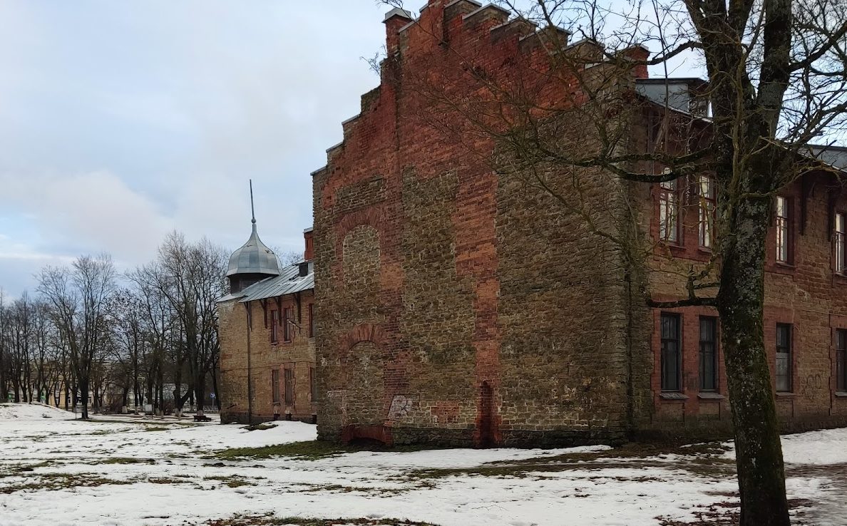
The route from Saint Petersburg to Narva crosses the former detinets. The former Commercial School stands beside the road on the northern side of the site and now houses the local-history museum. The park also contains the 1958 partisan monument in its southeastern corner and the remains of the former Soviet cinema and dance area.