Tiya Archaeological Site: A Cemetery of Carved Stone Stelae in Ethiopia
Site at a Glance
- Popularity
- High
- Country
- Ethiopia
- Primary era
- Medieval
- Eras represented
- Medieval
- Civilizations
- Unclassified
- Site type
- Burial
- Remains
- Necropolis
On this page18 sections
History
The Tiya archaeological site is a cemetery marked by carved stelae, upright stone slabs, in Tiya, Ethiopia. Their construction is generally placed between the 10th and 15th centuries, though the date remains uncertain. The monuments form part of a long tradition of stone construction in Ethiopia, where examples are known from before the Common Era.
Regional setting and dating
The site lies in the Gurage Zone, south of Addis Ababa. The wider area was occupied over a long period, in part because the plateau between the deeply cut Aleltu and Dedeba rivers forms a passage that travelers had to cross. Tiya is one of nine megalithic pillar sites in the zone and a major regional monument site. By 1997, more than 100 stelae had been recorded across the region; Tiya is the southernmost site of its type.
Proposed dates vary. Roger Joussaume associated the stelae with the 11th to 13th centuries, while other estimates place their construction between the 10th and 15th centuries. Radiocarbon measurements on a human bone and a piece of wood from the site fall in the 12th and 13th centuries. The stelae have also been interpreted as markers of a large prehistoric burial complex.
The identity of the people who made the monuments is difficult to determine from the stones alone. Oral traditions have not resolved the question in many cases, and some historians have proposed either an Aksumite origin or a connection to a shared regional culture. Local residents call the stelae “Gran’s stones,” associating them with Ahmad ibn Ibrahim, also known as Ahmad Gragn, a ruler of the Adal Sultanate, a Muslim polity in the Horn of Africa. The monuments predate his lifetime. Their sword designs may instead reflect a local Oromo type.
Recording and conservation
The earliest recorded descriptions of Tiya’s stelae date to 1905, when Lieutenant Victor Chollet and Henri Neuville wrote about them. Lincoln de Castro described the monuments in 1906. In 1926, Father Azaïs and Roger Chambard carried out a limited excavation near a large broken stele; about 15 stones were then still standing. A German ethnographic expedition visited in April 1935 and noted sword-marked stones south of its camp, at a place previously seen by Neuville and Father Azaïs.
A French archaeological mission led by Francis Anfray mapped the site and systematically recorded the carvings in 1977. Its plan showed two groups, with just one stele still upright. Roger Joussaume directed excavations in 1982, 1990, and 1991; work in 1982 identified a third group. In 1980, UNESCO added Tiya to the World Heritage List as a cultural property, recognizing its distinctive stone monuments. Restoration in 1998 included drainage, rejoining broken stelae, and raising fallen ones.
Remains
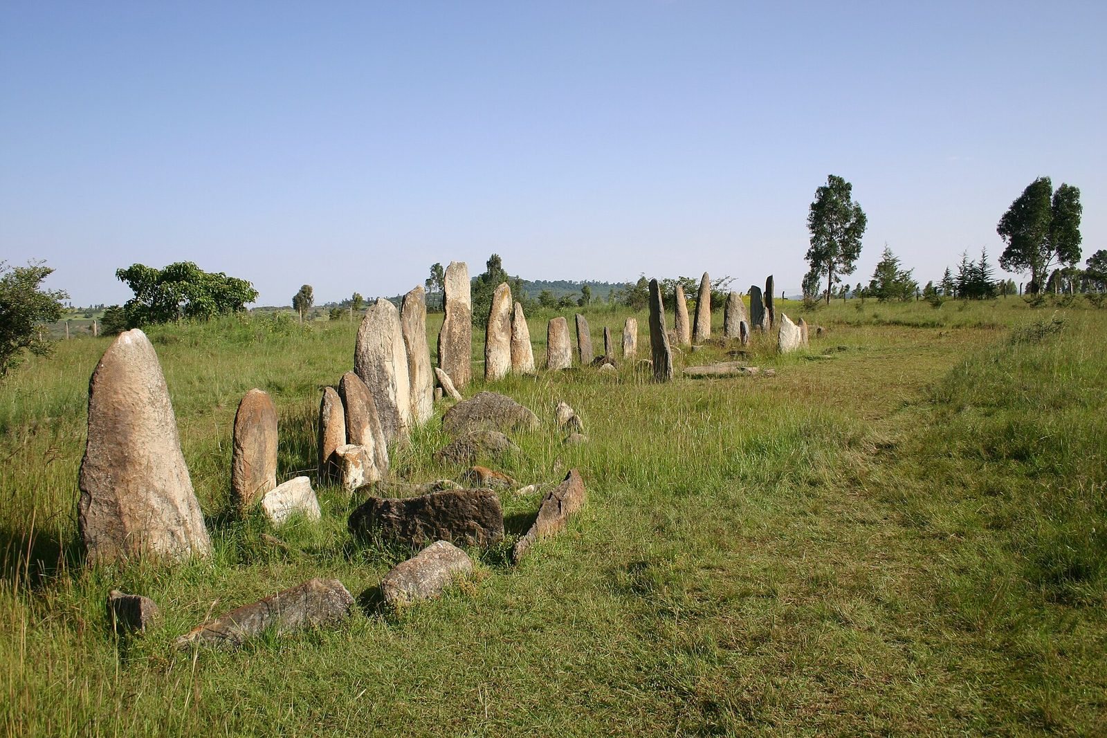
The cemetery is arranged in three groups of stelae, with graves associated with the monuments. The slabs were shaped from ignimbrite, a rock formed from volcanic ash flows. The site contains 46 stelae, 38 of them carved, with the groups and their decorated faces forming the main elements of the surviving layout.
The three stele groups
Group A
Group A contains about 40 stelae aligned along a southeast-to-northwest axis for nearly 50 metres. Most of their carved faces point east. A pit at the northern end of the group contains pottery, animal bones, beads, obsidian, and an iron rod, described below.
Group B
About 25 metres northeast of Group A, Group B contains four stelae. Its tallest is 5 metres high and carries 19 sword carvings in two levels. The top is broken away; the detached upper portion was moved and erected in the park of the Institute of Ethiopian Studies in Addis Ababa.
Group C
Group C lies about 25 metres west of Group A and also contains four stelae. Its largest monument stands 2.80 metres high.
Stone forms and carvings
Construction and shape
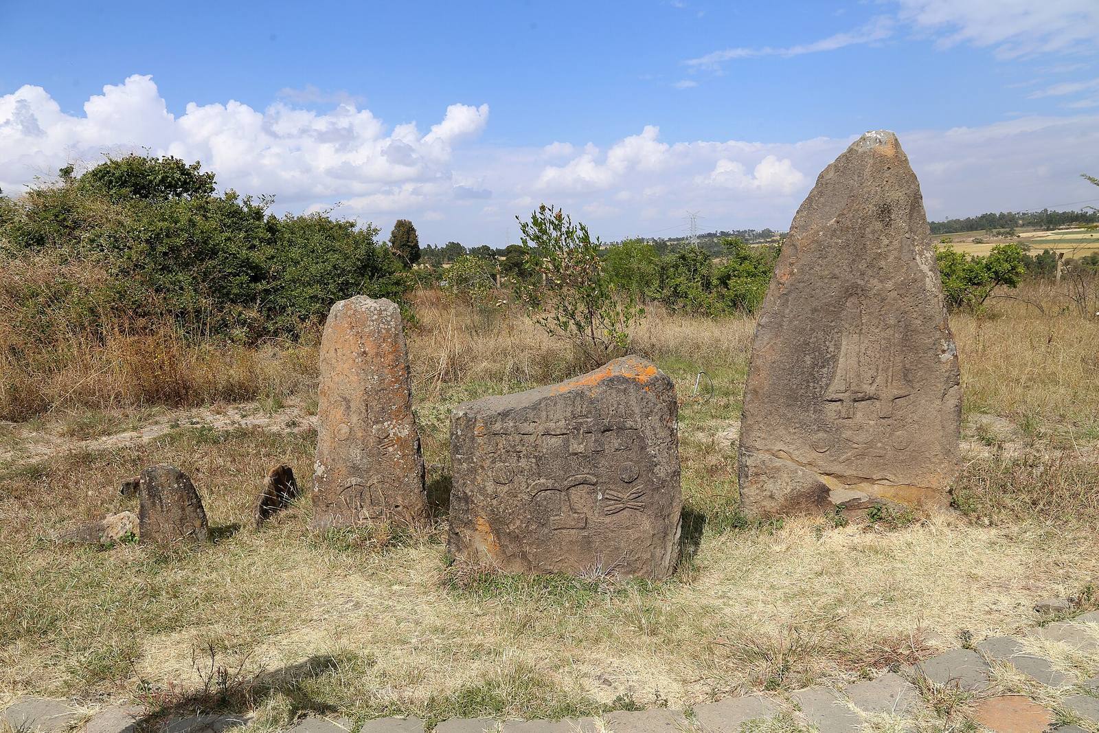
The stelae range from 1.30 to 5 metres in height. Their ignimbrite blocks were shaped and smoothed with metal tools resembling adzes. One to three holes, each about 15 centimetres across, appear at the base of each slab and are buried when it stands upright. Gurage stelae are classified as human-shaped, phallic, or neither. The human-shaped and neither-human-shaped-nor-phallic forms are flat, a shape described as unique to southern Ethiopia.
Carved imagery
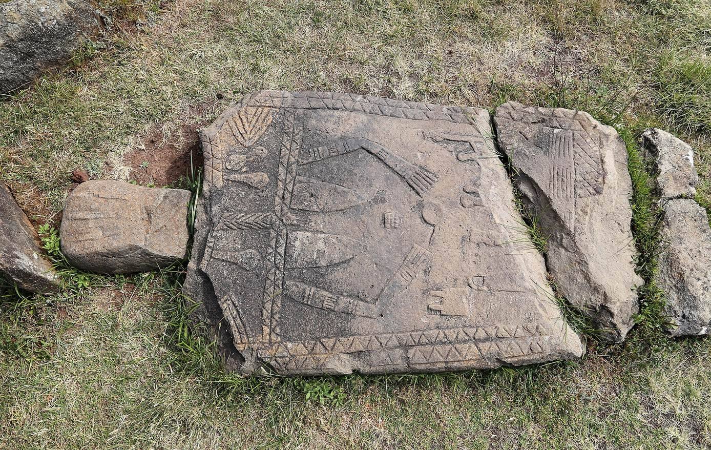
Relief carving appears on one face of a stele, in one or two levels, and some stones retain traces of paint. A common design on the lower level combines a branched sign, an X-shaped or inverted-W motif, and two circles. Where a second level occurs, it often carries swords: a single sword points upward, while swords in multiple rows are arranged head to tail. Other carved designs include plant-like forms, a standing figure with hands on the hips, and a T-shaped sign. Plant and sword imagery can appear together.
Interpretations of the designs
The branched sign occurs on stelae across the region and resembles scarification worn above the navel by Dinka people, a visual comparison rather than evidence of a historical connection. The X-shaped and inverted-W designs remain unexplained. Joussaume suggested that the holes at the base might represent a passage between the worlds of the living and the dead. He also proposed that the number of swords could refer to enemies or dangerous animals killed by the person buried beside a stele.
Graves and burial evidence
Grave layout
Each stele stands near a grave on the side opposite its decorated face. The graves are circular shafts, sometimes more than 2 metres deep, that may have wooden linings and are covered with a stone slab or branches. At ground level, upright slabs set on edge form polygonal enclosures; some have a decorated slab along one side. Graves added around an initial burial can create clustered, cell-like arrangements. A separate group lies behind Group A to the west. These burials are often female and only rarely have an associated stele.
Burials and associated finds
Graves could contain one person or several, with as many as three burials in a grave. In collective burials, bodies could be placed one above another, sometimes with a wooden floor between them; bones from earlier occupants were reduced. Excavation of 45 graves recovered the remains of 54 people, including seven double burials and one triple burial. Where sex could be determined in double burials, the pairs consisted of a man and a woman. The triple burial contained a man and woman around 30 years old and an adolescent aged 12 to 15. Most of the deceased were between 20 and 30 years old. Average heights were about 1.70 metres for men and 1.62 metres for women; the skeletons were in very poor condition.
Grave goods included multicoloured glass beads, an iron bracelet, and an iron hairpin. Pottery fragments and obsidian flakes found above graves are thought to have served as offerings.
Other archaeological finds
Northern pit
The pit at the north end of Group A measures 5.80 by 4.20 metres and is 1.10 metres deep. It contained stone blocks in the centre, numerous pottery fragments, animal bones, mainly cattle, multicoloured glass beads, obsidian flakes, and an iron rod. Some of the obsidian flakes had been worked into scrapers. The black, well-smoothed pottery has varied decoration, including fluting, small knobs, stamped designs, cord impressions, and geometric bands of incised lines. The pit may have belonged to a settlement contemporary with the cemetery.
Surface stone tools
Stone tools found on the surface belong to the Middle Stone Age, a prehistoric period associated with distinctive stone-tool industries. Their technology resembles tools from Gademotta and Kulkuletti. The use of a distinctive technique involving blows to shape the tools may indicate that they date to a similar period as material from those sites.