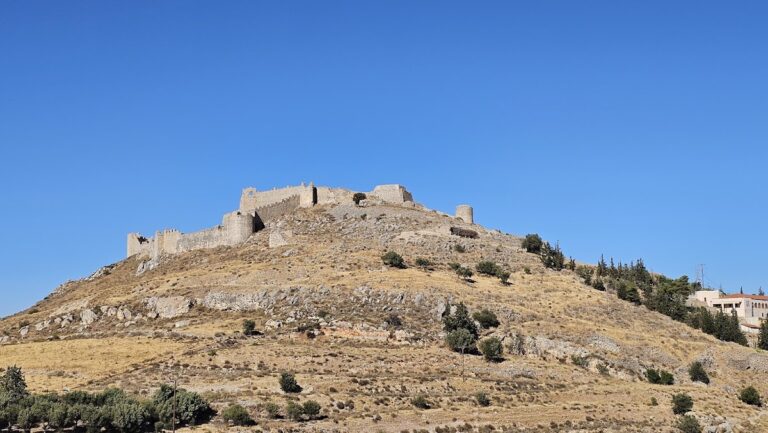
Tiryns: A Mycenaean Citadel and Palatial Center
Site at a Glance
- Popularity
- Very High
- Country
- Greece
- Primary era
- Bronze Age
- Eras represented
- Bronze Age, Iron Age, Medieval
- Civilizations
- Ancient Greek, Byzantine, Mycenaean
- Site type
- City
On this page19 sections
History
Tiryns is an ancient citadel and palatial center in the Peloponnese, Greece, whose greatest prominence came during the Mycenaean period, especially in the fourteenth and thirteenth centuries BC. Occupied from at least the Neolithic period into late antiquity, it became a fortified center linked to Mediterranean exchange and was the Mycenaean palatial center closest to the sea.
Bronze Age growth
A substantial settlement occupied the hill and surrounding area late in the Early Helladic II period, an early phase of Bronze Age mainland Greece. The citadel later developed as an elite Mycenaean center. By the Late Helladic II or IIIA1 phase, an elite presence had emerged; in the fourteenth century BC, the center underwent palatial reorganization. Fortifications were extended in stages from the upper citadel to the lower one.
Around 1300 BC, the citadel and lower town together are estimated to have covered 20 to 25 hectares, with a population of about 10,000. The lower citadel already had a stone defense by the Late Helladic IIIB1 phase. In the final decades of the thirteenth century BC, a major building program reshaped the palace, altered access to the upper citadel, and strengthened the lower one. At the same time, terraces and buildings for administration, storage, and craft production were laid out there. A dam and a diverted stream helped limit flooding and supported expansion north of the citadel.
At the end of the Late Helladic IIIB2 phase, a catastrophe destroyed the palace and damaged buildings in both the citadel and lower citadel. A major earthquake has been proposed as a likely cause, while some lower-citadel buildings also show evidence of fire. Tiryns was resettled after the palace’s destruction, unlike many other Mycenaean centers. Its population is estimated to have reached about 15,000 by 1150 BC. Settlement expanded in the lower town, especially north of the citadel, as new buildings and houses appeared in the post-palatial period.
Post-palatial settlement and Iron Age sanctuary
On the upper citadel, people levelled the palace debris, remodelled the altar in the great court, and built Building T within the outline of the former main hall. In the lower citadel, temporary occupation gave way to houses arranged around courtyards, a pattern that continued through the post-palatial period. Later in the Late Helladic IIIC phase, substantial buildings were erected in both the lower citadel and lower town. Several lower-citadel buildings were destroyed again near the end of that phase, probably by an earthquake, but occupation continued into the late Mycenaean period.
The settlement eventually contracted, and the lower citadel was almost abandoned. Some inhabitants appear to have moved to the lower town or to other settlements in the region, including Asine. Evidence for continued life in the Sub-Mycenaean period and Early Iron Age, the transition from the Bronze Age, comes mainly from outside the citadel. An apsidal building, meaning one with a curved end, west of the lower citadel and houses west of the upper citadel date to the beginning of the Protogeometric period, an early Iron Age phase. Building T probably remained in use during the Early Iron Age.
A sanctuary developed on the upper citadel in the eighth century BC, by which time Building T was probably already badly ruined. A temple was later built over the palace remains, around 650 to 625 BC. The deity of the earliest cult is uncertain; Hera is associated with the place in a later period.
Argive conquest and ancient traditions
In the fifth century BC, Argos conquered and destroyed Tiryns in 468 BC. Pausanias says the inhabitants were transferred to Argos to increase its population, while Strabo reports that many Tirynthians moved to found Halieis, identified with modern Porto Heli. Herodotus relates that, after the Spartan king Cleomenes I defeated the Argives, enslaved Argives occupied Tiryns for many years. He also records that Tiryns sent 400 heavily armed infantrymen, or hoplites, to fight at the Battle of Plataea in 480 BC.
Ancient traditions connected Tiryns with legendary rulers and heroes. One story made Proetus, son of Abas and brother of Acrisius, its founder and ruler after he returned from exile and took the city. Another credited the Cyclopes, mythical beings of extraordinary strength, with building its walls. Stories linking Acrisius with Argos, Proetus with Tiryns, and Perseus with Mycenae also served later claims about Argos’s regional leadership and prestigious past.
Other myths linked the city to its namesake hero, whom Pausanias described as a son of Argos and grandson of Zeus. In one account, Perseus gave up Argos after accidentally killing Acrisius, exchanged kingdoms with Megapenthes, and ruled at Tiryns. Bellerophon was said to have received purification at the court of Proetus. Stories of Heracles placed him at Tiryns during his labors and, in some traditions, named it as his birthplace. One tale says he killed Iphitus, son of Eurytus, by throwing him from the walls.
In the Iliad, Homer includes Tiryns among the territories led by Diomedes and praises its massive walls. Pausanias visited the ruins in the second century AD and compared the walls’ impressiveness with that of the Egyptian pyramids. Tiryns continued to attract attention after losing its political independence. In the Byzantine period, a church and cemetery were established west of the upper citadel, probably beside a small settlement. Venetian records later called the site Napoli Vecchio.
Archaeological investigation and protection
Travellers and antiquarians recorded Tiryns from the late eighteenth to early nineteenth centuries. Drawings by Fauvel and topographical work by William Gell, Edward Dodwell, and William Martin Leake preserve information about the site before major excavations; Gell’s work on Argolis appeared in 1810. The first archaeological exploration took place in September 1831, when Alexandros Rizos Rangavis and Friedrich Thiersch briefly investigated the upper citadel and believed they had found the palace.
Heinrich Schliemann visited in 1868 and opened 24 trial trenches in 1876. At first he mistook the palace for a medieval building, a misunderstanding that nearly led to damage to the remains. He returned in 1884 with greater archaeological experience and, with Wilhelm Dörpfeld, carried out the first systematic campaign in 1884 and 1885. Their work uncovered much of the latest Mycenaean palace and established an overall plan.
Excavations from 1905 to 1929, led by Dörpfeld and later Georg Karo and Kurt Müller, extended investigation to the middle and lower citadels, lower town, and burial areas. In 1915, while Karo was away, Apostolos Arvanitopoulos excavated the deposit known as the Tiryns Treasure. Work resumed after the Second World War through the German Archaeological Institute and the Greek Archaeological Service. From the late 1950s, Nikolaos Verdelis directed restoration that brought the lower-citadel cisterns to light, while rescue excavations in the lower town continued for decades.
Later campaigns led by Ulf Jantzen and Klaus Kilian clarified the lower citadel’s development and added evidence from the palace area. Joseph Maran began directing excavations in 1997, joined by Alkestis Papadimitriou in 1999. Work extended from the upper citadel into several parts of the lower town, broadening understanding of Tiryns beyond its palace. Since 1999, Tiryns has belonged to the UNESCO World Heritage property shared with Mycenae, recognized for its architecture and evidence of ancient Greek civilization.
Remains
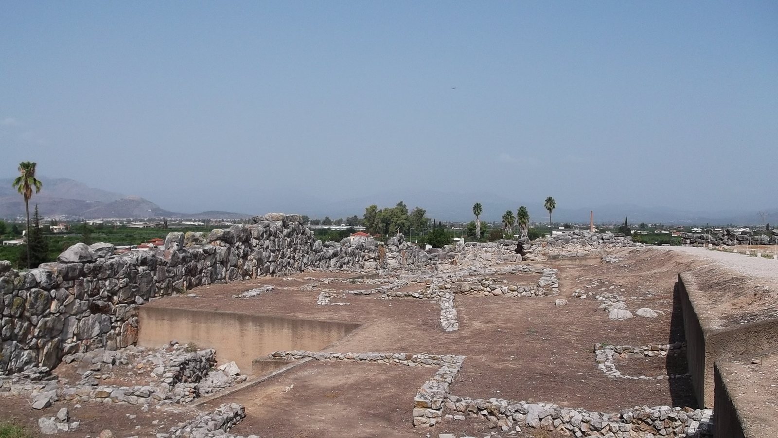
Tiryns occupies a narrow limestone spur running north to south, about 300 metres long and 45 to 100 metres wide. The hill rises no more than about 18 metres above the surrounding ground, and its highest point reaches about 26 to 28 metres above sea level. Its surface slopes gently down toward the north. In the Late Helladic period, the citadel comprised three terraces in sequence: the upper citadel at the southern end, the middle citadel, and the lower citadel to the north. Retaining walls linked these levels to the outer defenses. A lower town extended around the citadel. During the Bronze Age, the Argolic Gulf coast lay about 500 metres from the hill in the Early Helladic period and about one kilometre away in the Late Helladic period.
Citadel and defenses
Fortification circuit
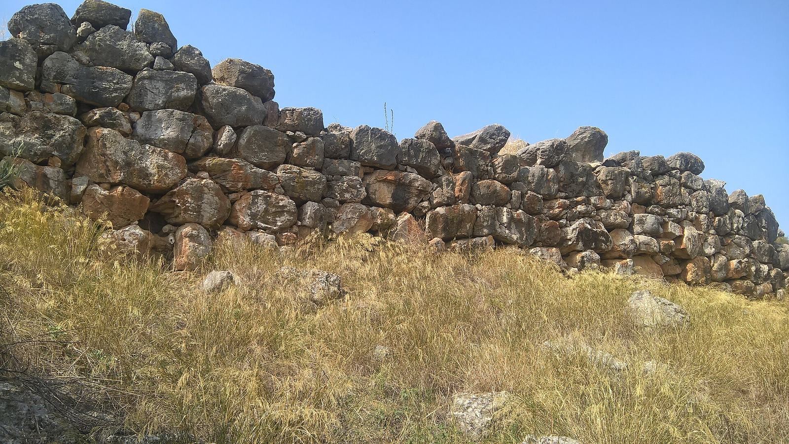
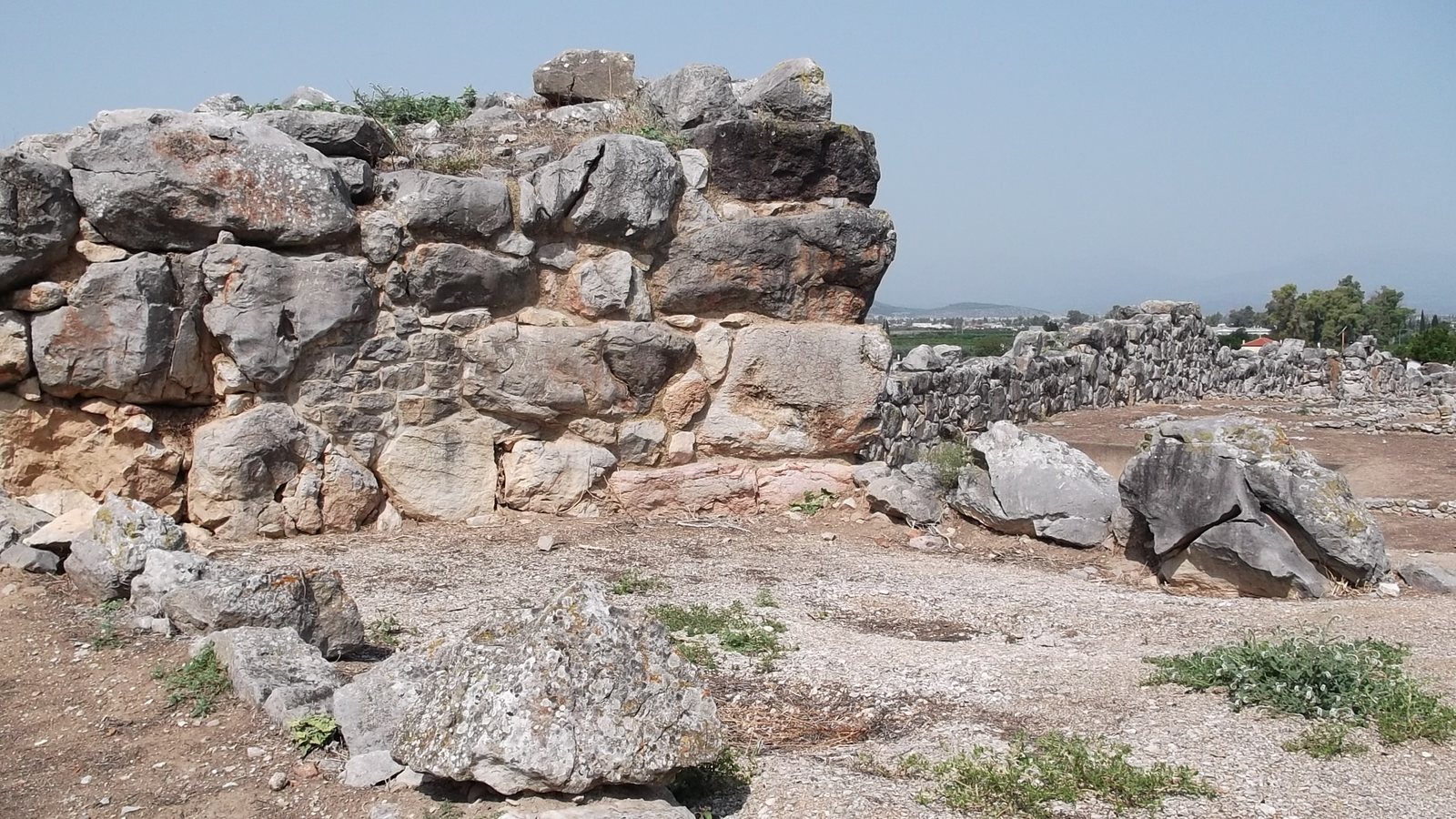
A continuous circuit of Cyclopean masonry, construction using very large stone blocks, encloses the citadel. The limestone blocks were laid without mortar, and some are larger than those used in Mycenae’s defenses. The circuit runs for about 750 metres. Its walls are generally 6 to 8 metres thick, reaching about 17 metres where passages and galleries pass through them. Their bases survive around the full circuit, and surviving sections rise as much as about 7 metres. The original height is estimated at roughly 9 to 13 metres, with the higher estimate applying to the best-preserved stretches.
The earliest defenses enclosed only the upper citadel; successive building phases expanded the circuit to include the lower citadel, reaching its final layout at the end of the thirteenth century BC. A substantial cross-wall divides the citadel. The southern part contained the palatial buildings, while the northern part protected the hilltop and dates to the end of the Mycenaean period.
Entrances and passages
The principal entrance was on the eastern side, though its position and form changed through three building phases. The earliest entrance was a narrow passage flanked by two inward-projecting defensive structures. In the second phase, the gate resembled Mycenae’s Lion Gate: a tower stood on the left and a projecting wall on the right, narrowing the exposed approach. The third phase shifted the entrance farther outward.
Small gates and numerous passages occur in the northern defenses. Some tunnels have roofs formed by corbelling, a method in which each higher course of stone projects inward. These routes provided refuge for people from the lower town in times of danger. Galleries in the southern and eastern walls contain side chambers roofed with projecting courses of stone; spaces opening from the corridors have been interpreted as storerooms and service passages.
Palatial complex
Upper-citadel palace
The palace stood at the summit of the upper citadel. The thirteenth-century BC complex reused the site of an earlier megaron, a large hall usually organized around a central hearth, built in the fourteenth century BC. The later palace shifted several metres north, moving the hearth and throne slightly as well. From the eastern entrance, ramps, doors, thresholds, and courts led to the great court in front of the principal megaron.
Aligned north to south, the principal megaron had three spaces arranged along one axis. Its portico measured 9.65 metres wide by 4.80 metres deep, with two columns between projecting wall ends. Beyond it, the vestibule measured about 9.70 by 4.72 metres. The roughly square throne room measured about 9.75 to 9.86 by 11.81 metres. A circular hearth occupied its centre, surrounded by four wooden columns that supported the roof. The throne stood against the eastern wall on a low rectangular base. A western doorway from the vestibule opened into the west wing, and an opening to the north led into the main hall.
The portico walls had alabaster slabs at the bottom, decorated with relief rosettes and flowers, with frescoes above. Painted decoration also covered floors and walls. Fragments found in destruction deposits on the upper citadel’s western slope show hunting scenes and women in procession.
A second, smaller megaron had its own entrance and no direct connection to the principal one. Modern scholarship has called the arrangement a double palace, but the smaller hall’s purpose remains uncertain.
Middle-citadel buildings
A route through the middle citadel included passages and courts, a portico, a large monumental entrance structure, another court, and a second, smaller entrance structure. The larger entrance was angled slightly northward so that someone inside it could see the smaller one on the opposite side of the court. The middle citadel’s function is uncertain; proposed interpretations include a garden or buildings connected with the palace.
Lower-citadel buildings
The North Gate and Buildings XI and XV belong to the final palatial phase. A corridor between the two buildings led to the gate. Building XI is only partly excavated and has at least five rooms. The remains of later lower-citadel occupation include temporary dwellings, houses arranged around courtyards, and a sanctuary in Room 117 that opened onto a court. Building VIa reused the walls of the earlier palatial Building VI.
Other lower-citadel structures include Room 127, with Court H 3 in front, and Room 115, reconstructed as a three-aisled hall beside Sanctuary 110. Room 115 had at least some religious function. Megaron W and the large Room 106.a.124, interpreted as an elite residence, also belong to the late Mycenaean remains; a seal impression was found with this group of evidence. Outside the citadel, a large building with multiple columns stood in the lower town.
Early building and water management
Circular building
An Early Helladic II circular structure occupies the highest point of the upper citadel, though its centre is partly covered by the later palace. Its estimated original diameter was 27.9 to 28 metres, with a circumference of about 88 metres. The foundations are 4.70 metres wide overall, and the wall itself is 1.85 metres thick. Three concentric rings without openings formed the plan. About 15 compartments were associated with the outer ring, and a similar number with a narrower second ring. The central space, about 10 metres across, stood higher than the surrounding compartments and may have been separated from them by another ring wall.
The building had a stone base, a mudbrick upper structure, terracotta roof tiles made from fired clay, and slate roofing slabs. Its roof was probably conical, with an estimated height of 26.4 metres to the peak. A single-storey reconstruction is better supported than a version with an upper floor. Suggested functions include a monumental residence, sanctuary, refuge, or communal granary. The granary interpretation treats the compartments as storage spaces and the thick outer mudbrick wall as support against the pressure of stored grain.
Cisterns, springs, and diverted stream
Underground cisterns cut into the thirteenth-century BC fortifications provided water during a siege. A well about 10 metres deep in Room 14, within the western wall of the lower citadel, became less important after the cisterns were constructed. Three springs also supplied water. One, on the western side of the great court, could be reached through a concealed entrance; two others at the northern end of the wall were accessible through passages within it.
In the Mycenaean period the Manesis stream flowed north of the citadel. A dam about 3.5 kilometres east-northeast of Tiryns diverted it into an artificial channel about 1.5 kilometres long, which carried water to a natural streambed farther south. The dam is about 10 metres high and 100 metres long, but its date is uncertain. It has been interpreted either as a response to heavy sediment deposits in the lower town at the end of the Bronze Age or as a late-palatial measure to limit flooding, support northern expansion, and improve access from the north.
Sacred and burial remains
Temple on the upper citadel
The temple built over the palace ruins incorporated two of the palace’s three megaron walls and was smaller than the earlier complex. Its plan included a porch and a cella, the main enclosed room of a temple. The building dates to about 650 to 625 BC.
Burials and deposited objects
Excavated burial areas include chamber tombs, burial places formed as chambers or cut into rock, and a tholos tomb on Profitis Ilias hill. A deposit of valuable objects was placed in a cauldron within the foundations of a Mycenaean house in the lower town around 1180 BC. It included gold and silver items and a Minoan signet ring, a ring bearing a design used to make an identifying seal, dating to the fifteenth century BC.