Thimlich Ohinga: A Fortified Pastoralist Settlement in Kenya
Site at a Glance
- Rating
- 4.5
- Popularity
- Very Low
- Country
- Kenya
- Primary era
- Medieval
- Eras represented
- Medieval
- Civilizations
- Unclassified
- Site type
- Military
- Remains
- Fortified Town
On this page15 sections
History
Thimlich Ohinga is an archaeological complex in Migori County, western Kenya. Built and used by successive pastoralist communities from around the fifteenth century or earlier, it formed part of a regional tradition of fortified settlements around the Kenyan shores of Lake Victoria. The complex is the largest of 138 known sites containing 521 stone structures in the region. Its walls and internal spaces reflect communal settlement, cattle keeping, defense, craft production, and social life.
Origins and successive occupation
The precise chronology of Thimlich Ohinga remains unresolved. Late Stone Age quartz flakes found at the site are considered earlier than the stone settlement itself. Oral traditions describe successive waves of occupation, with Bantu-speaking communities said to have preceded the arrival of Nilotic-speaking groups. The terms Bantu-speaking and Nilotic-speaking refer to broad language families and associated populations, rather than simple ethnic identities.
The identity of the original builders is therefore debated. Population movement and intermarriage in the Lake Victoria region before and during the colonial period make a single ethnic or linguistic attribution unreliable. The settlement’s spatial organization closely resembles traditional Luo homesteads, while pottery decoration resembles styles associated with Western Nilotic, particularly Luo, speakers. The Luo are an East African people whose language, Dholuo, belongs to the Western Nilotic branch of the Nilotic language family.
Oral traditions associate the enclosures with protection from wild animals, cattle raiders, and hostile groups. These included outsiders in the Kadem and Kanyamwa areas as well as neighboring communities from the territory that is now Tanzania. The complex also served as an economic, religious, and social center. Its scale indicates a community able to organize labor and resources, while pastoralism, especially cattle keeping, formed a central part of the economy.
Community change and abandonment
The original builders eventually left the settlement, although the circumstances remain uncertain. Communities that moved into the area between the fifteenth and nineteenth centuries repaired and altered the enclosures, allowing the structures to remain in use over successive generations. This continuing maintenance formed part of a broader regional pattern of migration, population change, and communal settlement among pastoralist communities.
Thimlich Ohinga was finally vacated during the first half of the twentieth century. Colonial administration brought greater peace and order to the region, and families moved from communal enclosures into individual homesteads. Euphorbia replaced stone as a common fencing material, accompanying a shift toward more individual forms of settlement.
Recognition and conservation
Neville Chittick, then director of the British Institute of History and Archaeology in East Africa, documented the site during the 1960s. Researchers from the National Museums of Kenya began systematic work in 1980. The site had previously been called Liare Valley, after a valley northeast of the area, but it was officially gazetted as Thimlich Ohinga in 1981 because the earlier name did not accurately describe its location.
The name comes from Dholuo. Thimlich means “frightening dense forest,” while Ohinga means “large fortress.” The Kenya Wildlife Service and the National Museums of Kenya designated the site for conservation, and the National Museums of Kenya has managed it under Kenya’s heritage legislation. Local customary rules and taboos also contribute to its protection.
Kenya nominated the site for UNESCO World Heritage status in 2014. After revisions that strengthened the comparative analysis, emphasized the settlement archaeology, and expanded the protected area, it was inscribed in 2018 as the Thimlich Ohinga Archaeological Site. The cultural World Heritage property is recognized under criteria concerning testimony to a cultural tradition, an important architectural and settlement ensemble, and a representative traditional settlement or land-use system. The property covers about 21 hectares, with a buffer zone of approximately 33 hectares.
The protected area was expanded to include archaeological evidence on privately owned land south of the main site, while the buffer zone was adjusted to safeguard the surrounding landscape. A management plan for 2017 to 2027 guides conservation and site administration. Collapsed wall sections have been repaired with locally available materials and traditional techniques, preserving the historic appearance while keeping the repairs visually close to the original masonry. Elders and other community members help protect the site by maintaining traditions and discouraging the cutting of surrounding vegetation or removal of stones. Friends of Thimlich Ohinga, a local association established in 2013, also supports its care.
Remains
Thimlich Ohinga stands on a gently sloping hill near Macalder’s mines, about 181 kilometres south of Kisumu and 46 kilometres northwest of Migori town. Its protected cultural landscape includes surrounding woodland inhabited by guinea fowl, monkeys, other birds, and antelope. The complex consists of four large interconnected enclosures: Kochieng, the largest, together with Kakuku, Koketch, and Koluoch.
Walls and entrances
Dry-stone enclosure walls
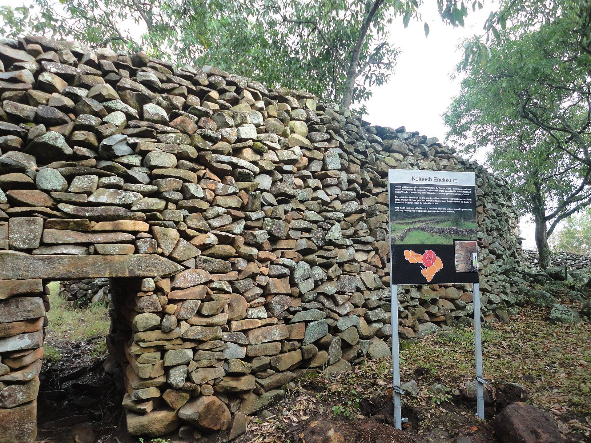
The main enclosure is built from undressed local basalt, rocks, and stones fitted together without mortar. The stones interlock within freestanding walls, whose curved and zigzagging lines form ovoid enclosures. Intermittent buttresses add stability, allowing the walls to stand without excavated foundations. The main walls are approximately 1 to 3 metres thick and 1 to 4.2 metres high. Other freestanding walls are about 1 metre thick and range from approximately 0.5 to 4.5 metres in height.
This construction is often compared with the smaller-scale architectural tradition of Great Zimbabwe, a medieval stone-built urban and royal complex in present-day Zimbabwe known for its large unmortared walls. Thimlich Ohinga differs in its use of irregular stones arranged in the local basalt masonry tradition. It is an example of defensive savanna architecture, a form whose later expressions appeared in parts of East and southern Africa and continued in some traditional houses in western and southwestern Kenya.
Gates and watchtower
The main monument has three entrances, one facing west and two facing east. Each gate has a stone lintel and engraved markings. The narrow, low passages required entrants to pass singly and stoop, helping guards control movement through the enclosure. Immediately inside the entrance stands a watchtower made from raised rocks, giving a view across the complex and its surrounding area.
Residential and livestock areas
Internal divisions
Inside the walls, corridors, smaller enclosures, depressions, and subsidiary fortified areas divide the settlement. The main monument contains six house pits and five enclosures. Circular depressions and raised platforms mark places where houses once stood. The smaller side forts included houses, dining areas, animal pens, and granaries, showing that the settlement combined domestic, agricultural, and defensive functions within its walls.
Animal pens and gardens
Central areas served as livestock pens for cattle, sheep, goats, chickens, and guinea fowl. Some pens had retaining walls associated with gardens. Low openings helped drain water and mud from the animal enclosures. Animal remains from the site include cattle, sheep and goats, chickens, fish, hartebeest or kongoni, duiker, and hare, representing both domesticated and wild species.
Craft, exchange, and social space
Ironworking area
A partially walled zone beside the main enclosure was used for ironworking. Iron slag, the stony waste produced during iron smelting, was found there together with a tuyère, a tube or nozzle directing air into a furnace, and iron objects. These remains indicate that metalworking took place within the settlement.
Game board and household equipment
The northeastern part of the main enclosure contains a recreational area with an ajua board carved into the surface of the rock. Ajua is a Mancala-like game in which counters are moved among carved hollows or pits. Grinding stones for grain were also found at the site, providing evidence of food processing within the settlement.
Pottery and trade goods
Pottery from Thimlich Ohinga and related stone settlements bears decorative patterns commonly associated with Western Nilotic or Luo speakers. Imported glass beads indicate that the community participated in long-distance trade. Together with the circular residential arrangement, central livestock enclosure, and focal meeting area, these finds contribute to the interpretation of the complex as a settlement organized around communal life and pastoral production.