Tash Rabat: A Silk Road Caravanserai in Kyrgyzstan


Site at a Glance
- Rating
- 4.6
- Popularity
- Low
- Country
- Kyrgyzstan
- Primary era
- Medieval
- Eras represented
- Medieval
- Civilizations
- Unclassified
- Site type
- Economic
- Remains
- Caravanserai
On this page8 sections
History
Tash Rabat is a high-altitude stone caravanserai in Kyrgyzstan, associated with the Silk Road route across the Central Tian Shan and generally attributed to the fifteenth century. A caravanserai was a roadside lodging and service complex for merchants, caravans, and travelers on long-distance trade routes. Tash Rabat provided shelter, and possibly protection during raids, for people crossing the mountains toward the cities of the Fergana Valley.
Early foundations and changing interpretations
The main building is commonly dated to the fifteenth century, with one chronology placing its construction around 1408–1416. The site’s earlier history remains uncertain. Some interpretations hold that the surviving structure replaced or incorporated a monastery from the ninth or tenth century, while other accounts focus on the fifteenth-century building itself.
Two foundation traditions preserve different explanations for the site’s beginnings. One attributes the establishment of a fortress to a khan who wished to protect trade caravans and contribute to the development of the country. The other connects the construction with a wealthy local person whose project was left unfinished for unknown reasons.
The building’s original purpose has also been debated. In 1888, the Russian doctor and traveler Nikolay Lvovich Zeland proposed that it had first been an East Syrian or Buddhist monastery. From the late 1970s to the early 1980s, the Institute of History of the Kyrgyz Academy of Sciences identified it as a tenth-century Nestorian monastery. A Nestorian monastery belonged to the Church of the East, a Christian tradition historically established across parts of the Middle East and Central Asia. Excavations produced no Christian artifacts, however, and later interpretations identified the site as a Buddhist monastery because its inscriptions and artifacts were Buddhist in character and the area’s inhabitants were Buddhist at the time. Tash Rabat has also been studied as a khanqah, a Sufi religious lodge used for communal worship, teaching, and residence.
Caravanserai on the mountain route
As Islam became firmly established in Central Asia, the earlier monastery is described as having declined. Its position beside the Silk Road nevertheless kept the site connected to long-distance travel, and the building was reused as a caravanserai. It stood near the route through the Kara-Koyun gorge and toward the Torugart Pass, with caravans continuing onward to the Fergana Valley.
Tash Rabat lies in At-Bashy District of Naryn Province, near the Chinese border, at an altitude of more than 3,000 metres above sea level. Lake Chatyr-Kul is to the south, and the ruined fortress of Koshoy Korgon lies to the north. These landmarks place the building within the mountain corridor through which travelers crossed the Tian Shan.
Written descriptions and archaeological study
The historian Muhammad Haydar gave the earliest recorded mention of Tash Rabat in the second half of the sixteenth century and considered it to have been built in 1408–1416. The Kazakh scholar Chokan Valikhanov described the building in 1859. In 1878, the Russian traveler A. M. Fetisov characterized it as a free “travelers’ hotel” where caravans and other travelers could spend the night.
An archaeological expedition led by A. N. Bernshtam investigated Tash Rabat in 1944, identified it as a caravanserai, and emphasized the influence of nomadic traditions on its architecture. Further investigations followed by Central Asian architectural and archaeological researchers. The monument is also depicted on Kyrgyzstan’s 20-som banknote.
Remains
Plan and entrance
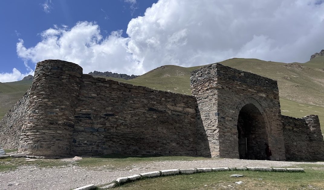
Tash Rabat is a square stone building with an east-facing facade. It rises roughly 20 metres and contains 31 domed rooms, including the main hall. The plan is arranged in three connected groups: a long entrance corridor, rooms placed on both sides of that passage, and a principal hall surrounded by additional rooms and smaller halls.
The first doorway opens toward three guard rooms. The entrance corridor then continues into the building, leading to the main hall at the western side. Towers reinforce the eastern corners, giving the facade a defensive character that accords with the building’s use as shelter on a difficult mountain route.
Main hall and vaulted rooms
The main hall occupies the centre of the building’s western side and measures 9.32 by 8.35 metres. It is linked to surrounding rooms and smaller halls and is covered by a dome approximately 9.30 metres in diameter. The other rooms are square or rectangular, with hemispherical or otherwise domed vaults.
Openings at the tops of the rooms admitted light. Squinches, architectural devices that bridge the corners of a square room to create a base for a dome, made the transition from the quadrangular wall frames to the domes. One of the most distant rooms contains a deep hole in the floor that may have been a well, although its function remains uncertain.
Stone construction and present fabric
The walls were built from stone set in clay mortar. Descriptions vary between dressed stone and rubble stone, while gypsum mortar was used to seal the joints. The rooms and domes were plastered with alabaster and decorated with geometric patterns. A nineteenth-century description gives the building’s dimensions as approximately 12 by 7 sazhen, historical units of length used in Central Asia and the Russian Empire, and describes a long corridor leading to a circular hall with a radius of 5 kez, another historical unit of length. The same description suggests that the building may once have been plastered inside and outside.
The surviving structure is described as well preserved. Its present setting includes a large corrugated roof and a fence, with a parking area directly in front of the building. Together, the square plan, reinforced eastern corners, long entrance passage, and clustered domed rooms preserve the physical arrangement of a high-altitude lodging complex on the Tian Shan route.