Hanau Town Fortifications: Defenses of Alt-Hanau and Neustadt
Site at a Glance
- Popularity
- Medium
- Country
- Germany
- Primary era
- Early Modern
- Eras represented
- Medieval, Early Modern, Modern
- Civilizations
- Holy Roman Empire
- Site type
- Military
- Remains
- Wall
On this page23 sections
History
Medieval settlement and defenses
Hanau Town Fortifications were the successive defenses of Alt-Hanau and Neustadt in present-day Germany. Built and extended by Hanau’s ruling lords and counts, they developed from the thirteenth through the seventeenth centuries: from medieval defenses to a Renaissance system begun in 1528, then to an expanded fortress associated with the creation of Neustadt. Hanau’s position beside the Kinzig aided its defense, while the town also served as a market and lay on the Frankfurt–Leipzig and Frankfurt–Nuremberg trade routes.
A castle at Hanau is thought to have been established in the twelfth century. Dammo von Hagenowe is associated with it in 1143, while the castle itself appears in a record from 1234. The Lords of Hanau-Buchen are credited with building it; after 1170, the Lords of Hanau-Dorfelden took possession. The settlement grew under the castle’s protection. King Albert I granted it town rights in 1303, and a town wall probably followed around that time. A church described in 1338 as outside the town provides evidence that the wall then marked the town’s boundary. The Water Tower is also first mentioned that year.
The castle and town formed a connected but legally uneven community. Farms belonging to the castle’s retainers lay south of the town and outside its jurisdiction, while townspeople were chiefly responsible for keeping watch on the walls and streets. During the fifteenth century, a suburb arose beyond the Metzgertor on the Frankfurt road. A separate wall around this district is recorded in 1429, and another suburb later grew beyond its western gate.
Renaissance defenses and the new town
As artillery made older walls more vulnerable, Hanau’s rulers planned a new defensive system. Work began in 1528 under Count Philipp II of Hanau-Münzenberg and continued under his son, Philipp III, and during Philipp III’s minority under the regent Balthasar. Military engineer Reinhard zu Solms directed the design. Construction concentrated first on the southern side and continued to about 1540; work around the castle and northern defenses resumed in 1614. The new ring enclosed the old town, its Hospital suburb, and the castle, largely retaining the earlier defenses as an inner line.
On 1 June 1597, Count Philipp Ludwig II agreed to admit Calvinist refugees from France and the Spanish Netherlands to establish Neustadt Hanau. Calvinism is a branch of Protestant Christianity. A supplementary charter in 1604 amended the agreement. The count provided land outside the old town and financed infrastructure, especially fortifications, despite opposition from the Archbishop of Mainz, who claimed hunting rights in the area. Nicolas Gillet designed the new defenses, and René Mahieu led their construction until his death in 1607. When the count could not meet the costs, the new residents took responsibility for building work for three years from 1601 in return for town revenues and an annual payment; the count later resumed construction.
A separate settlement policy shaped life between the two defensive lines. In December 1603, Philipp Ludwig II allowed a Jewish community to settle in Hanau. Its members were assigned Jewish Lane, a ghetto, or restricted residential district, in the corridor between the medieval defenses and the Renaissance wall. The community answered directly to the count’s administration rather than either town government, while paying a poll tax to Alt-Hanau. The fortress was complete by 1619.
Hanau during the Thirty Years’ War
The Thirty Years’ War, fought across Europe from 1618 to 1648 amid shifting alliances among German rulers and foreign powers, brought the fortress its greatest military importance. The townspeople and the ruler’s garrison shared guard duties. Hanau was blockaded repeatedly and twice captured by surprise attacks, rather than by a successful assault that breached its defenses. Count Philipp Moritz initially supported the emperor and accepted an imperial garrison in March 1630. On the night of 10–11 November 1631, Swedish Lieutenant Colonel Christoph Hubald expelled the garrison, apparently with the count’s consent. Philipp Moritz then allied himself with Sweden’s King Gustavus Adolphus, and Swedish forces strengthened the town’s defenses.
Under Swedish commander Jakob von Ramsay, the works were extended and improved. Hanau became an isolated connection between Bernhard of Weimar’s forces on the Upper Rhine and Johan Banér’s Swedish army in northeastern Germany. Imperial-aligned territories surrounded the town; villages in the region were plundered, and the garrison also seized supplies. In September 1635, imperial commander Guillaume de Lamboy began a siege. Without heavy artillery, his forces relied chiefly on a blockade, restricting movement and supplies while hoping Hanau would surrender. Food shortages, plague, and the arrival of refugees made conditions inside the town increasingly difficult.
After nine months, a Hessian-Swedish force led by Landgrave William V of Hesse-Kassel and Swedish General Leslie relieved Hanau in June 1636. The fortress and its inhabitants also feature in Hans Jakob Christoffel von Grimmelshausen’s novel Simplicissimus, whose Hanau episode is set between the Battle of Nördlingen and the siege of 1635–36. In 1638, after Philipp Moritz had returned from exile and Ramsay had confined him in the castle, forces associated with the Wetterau Counts’ Association entered through Herrnmühle on 12 February. They freed the count and took the old-town defenses. The new town’s defenses did not protect it from an attack originating within the old town, leaving its garrison in a hopeless position. Ramsay was captured and died about a year and a half later from injuries sustained during the operation.
Demolition and urban change
The fortress was not brought up to date after the war. Repairs were made from time to time, but by the second half of the eighteenth century the defenses had become obsolete and were falling into decay. From after 1767, under Hereditary Prince William of Hesse-Kassel, defenses between Alt-Hanau and Neustadt were removed to create Paradeplatz and Esplanade, now Freiheitsplatz.
French troops entered Hanau on 3 November 1806, and an order from Napoleon two days later led to the fortress’s large-scale demolition during the winter of 1806–07, particularly its ramparts. A plan to build a larger, modern fortress in 1813–14 came to nothing amid public opposition, the elector’s reluctance to pay, and changing military circumstances. During the Battle of Hanau in 1813, French forces set fire to the suburb outside the Hospital Gate.
Clearance continued until 1829, when the medieval parts of the castle were taken down; the representative Frankfurt Gate was spared. The former fortified land was opened for development, initially often as gardens. New street openings and built-up outer districts followed from 1886. Later excavations exposed parts of the castle moat’s retaining wall in 2001 and 2002, while a large foundation block from a powder tower was uncovered in 1979.
Remains
Medieval castle and town defenses
The castle and its towers
The medieval castle stood on an island within a broad bend of the Kinzig, in the southern part of today’s Schlossgarten, north of the Stadthalle. Its earliest form was probably a cluster of buildings around a small courtyard, including a keep, with a defensive wall and moat. Part of the moat’s retaining wall has been exposed. It rests on an oak timber foundation dated by tree-ring analysis to 1302.
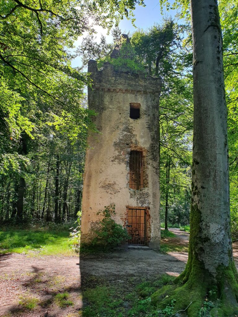
By 1375, an archive or dovecote tower protected the castle’s northeastern, open-country side. As the castle became the permanent residence of the Lords and Counts of Hanau during the fifteenth century, an enclosure was added on the side away from the town. It included a round eastern tower beneath a bell-shaped roof and mainly semicircular shell towers, which had solid outer faces and open or reduced inner sides. Later extensions toward the town led to the removal of defenses between the castle and its forecourt.
The old-town wall and Water Tower
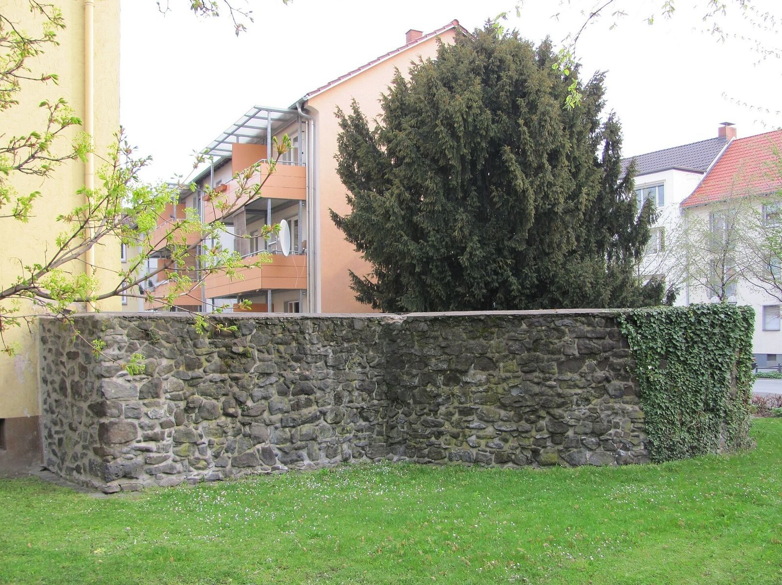
The old town’s wall, moat, and outer defensive corridor formed a perimeter about 800 metres long. Built from basalt rubble, also called dolerite, quarried near present-day Wilhelmsbad, the wall was about 1.4 metres thick and stood 6–7 metres high. A covered wall-walk ran along its top; brick arches resting on corbels widened the inner face. A second wall stood about six metres beyond it. Sewer work in Badergasse in 1951 and excavations in Nordstraße in 2001 revealed sections of this outer defense, which was about 85 centimetres thick.
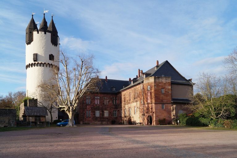
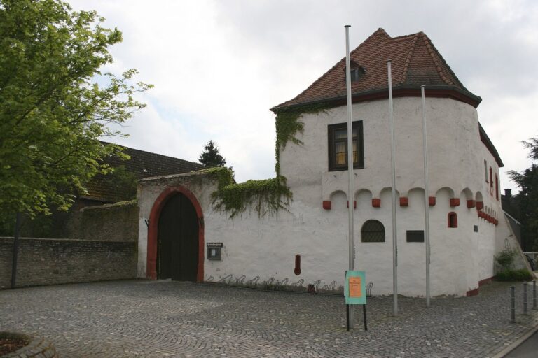
The old-town defenses included two gate towers and eight defensive towers, most built as shell towers. The Water Tower, named for its position between the town and castle moats, linked the two defensive systems. It is the only medieval defensive tower to survive almost completely. Sections of wall remain west of Old St John’s Church, on the west side of Schlenkergässchen, and behind the former Central Theater; parts of the wall-walk survive at some of these locations.
Other medieval towers
Towers guarded bends and exposed sections of the town wall. A rectangular tower behind Erbsengasse defended a southward turn, while semicircular towers stood at an eastern bend and along the southern wall. The southern tower was exposed toward Nordstraße after wartime destruction and demolished in 1950 along with a substantial stretch of wall. A round, enclosed tower at the southeastern corner was also known as the Witch Tower or Thief Tower. From 1605 to 1608, a room inside it served as a temporary synagogue. Its surviving foundation forms part of a memorial to the Hanau synagogue, which stood across Nordstraße and was destroyed in 1938.
Medieval town gates and suburbs
The Metzgertor, also called the Cat Tower, was the western entrance from the Frankfurt road. A small turret held a bell for condemned prisoners, and a clock with a hand was installed in 1510. As the Hospital suburb grew outside the gate, it lost much of its defensive function; it was demolished in 1771. The suburb’s western exit became known as the inner Hospital Gate, and a second suburb developed beyond it.
The Kinzdorfer Gate, or Kinztor, stood at the southern end of Marktgasse and led toward Kinzdorf and eastern trade routes. It was a projecting square tower with a vaulted passage and a bridge, ultimately a stone arch structure. After the new town was established, the gate served as a prison. It was demolished in 1769 and the nearby moat was filled; buried remains were observed during later construction near the south side of Freiheitsplatz and Marktstraße.
Renaissance fortifications
The outer ring
The sixteenth-century defenses formed a second line around the medieval town, Hospital suburb, and castle. Their southern side curved in a shallow semicircle and was strengthened by five bastions, projecting defensive works: two nearly square corner structures and three circular works known as roundels. The castle defenses on the north were rebuilt by about 1560. A surviving wall beside the footpath between former Jewish Lane, now Nordstraße, and the government building may be a remnant of this Renaissance line. A ten-ton foundation block from a powder tower at the bastion near the Jewish quarter was found in 1979 and moved to Sandeldamm, where it extends the line of the former ghetto wall.
The New Gate
The New Gate, also called the Marksmen’s Gate, was built in 1531 as a southern exit, set east of the road leading from the Market Gate. Sandstone portraits of Regent Balthasar and his deceased brother, Count Philipp II, with inscriptions, were attached to it. The gate was removed during work at Freiheitsplatz in the mid-eighteenth century, and its portraits and inscriptions were transferred to the Red Gate. The stones were privately saved when the ramparts were demolished and entered the Hanau Historical Society’s collection in 1875; they were destroyed during the Second World War.
The Hospital Gate and Kinzig bridge
The outer Hospital Gate, built in 1528 to defend the suburb, had a square tower and a vaulted passage. A projecting hornwork, an outwork extending from the main defenses, was added during the Thirty Years’ War. The gate was demolished in the early nineteenth century, either during the Napoleonic clearance or in 1816–17 when it obstructed traffic.
A stone arch bridge over the Kinzig, in front of the Hospital Gate, replaced a wooden bridge destroyed by flooding. Built between 1556 and 1559, it gained the Margarethen Tower at its second pier from the town in 1615. The tower served as a prison until 1829 and was then demolished. During the 1813 battle, French fire set the nearby suburb alight.
Neustadt fortress
Layout and water defenses
The Neustadt defenses formed five sections of a regular eight-pointed star. The remaining three points were occupied by Alt-Hanau’s older southern defenses, leaving the new town without a separate fortified line on that side. The design used a tenaille system, made up of inward-angled defensive faces. A moat fed by the Kinzig ran outside the rampart. The rampart’s outer face was masonry, with a narrow path between it and the water, reached from projecting gate structures. A parapet topped the wall, while bundles of brushwood supported its town-facing side. During the Thirty Years’ War, a sloping outer ditch face and open ground in front of the defenses were improved, and seven outworks were added, including substantial works near the Canal Gate, Hospital Gate, and Kinzig bridge.
The Nuremberg Gate
Built between 1600 and 1605, the Nuremberg Gate had a bridge completed by 1604. A severe flood damaged the gate and destroyed the bridge, and both were rebuilt in 1615–16. A small detached defense, called a lunette, was added during the Thirty Years’ War. The gate was demolished during the Napoleonic clearance.
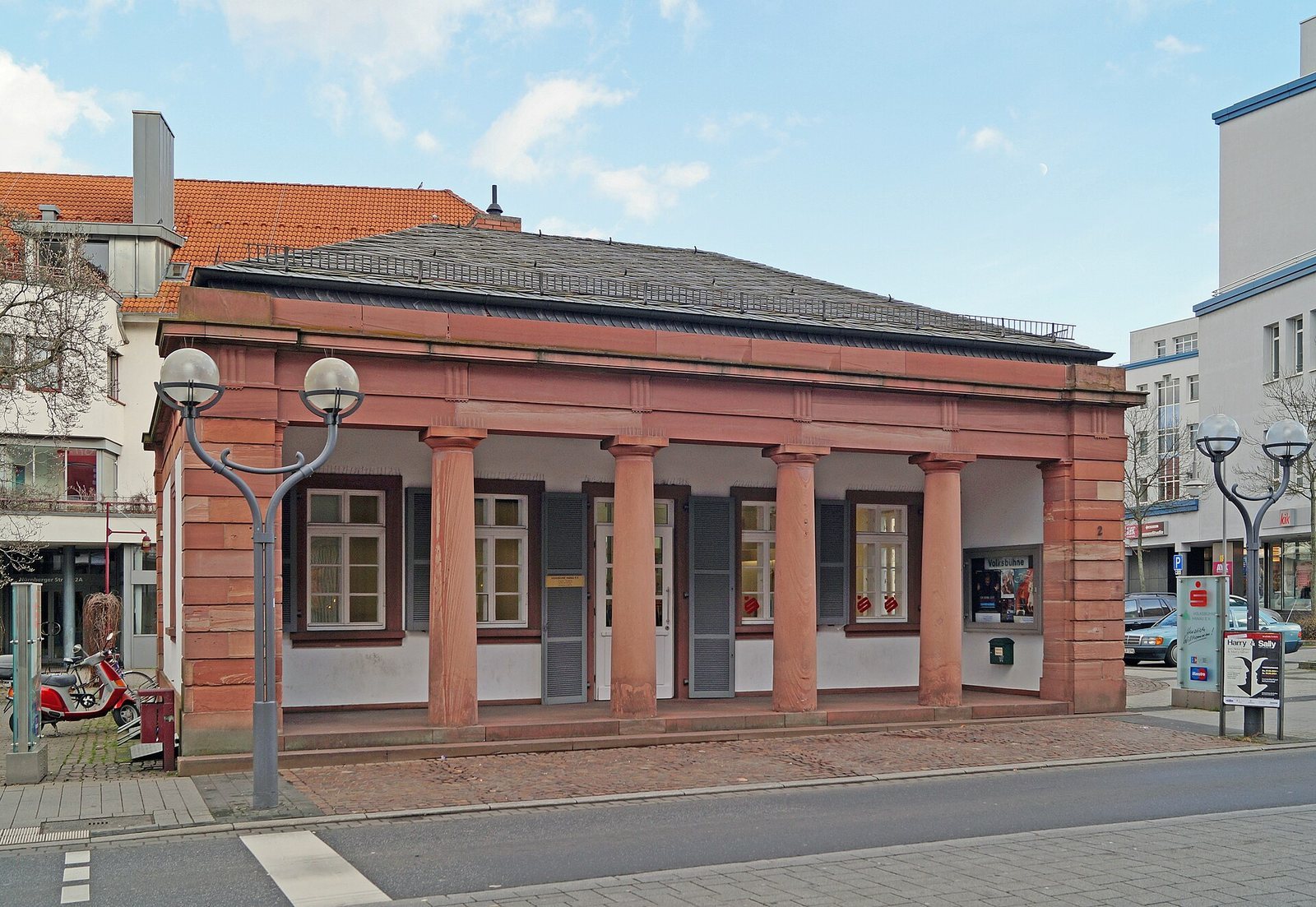
A replacement structure was erected in 1820 in the classical style, with two facing pavilions and a central grille that closed the road. It served customs rather than military defense. The grille was removed in 1867 as traffic increased. One pavilion was destroyed during the Second World War, while the southern pavilion survived and was moved to the north side of the road in 1981–82. It had housed a memorial to the First World War dead from 1935.
The Steinheim Gate
Construction of the Steinheim Gate began in 1600, and its tower was completed with a bell the following year. The gate closed in 1619 and its bridge was demolished. It remained shut until 1776 and was itself taken down in 1827.
The Canal Gate
Work on the Canal Gate began in 1609. It had separate openings through the rampart for road traffic and a water channel intended to connect a planned harbor with the moat. The gate was finished in 1611 and the harbor in 1617. A hornwork was added during the Thirty Years’ War. The harbor basin and canal gradually silted up; after the war the basin was abandoned, and a plan from 1684 shows the basin and the canal section connecting it to the moat filled in. The gate gained renewed importance after Philippsruhe Avenue was built in the early eighteenth century, then was demolished in 1829.
The Frankfurt Gate
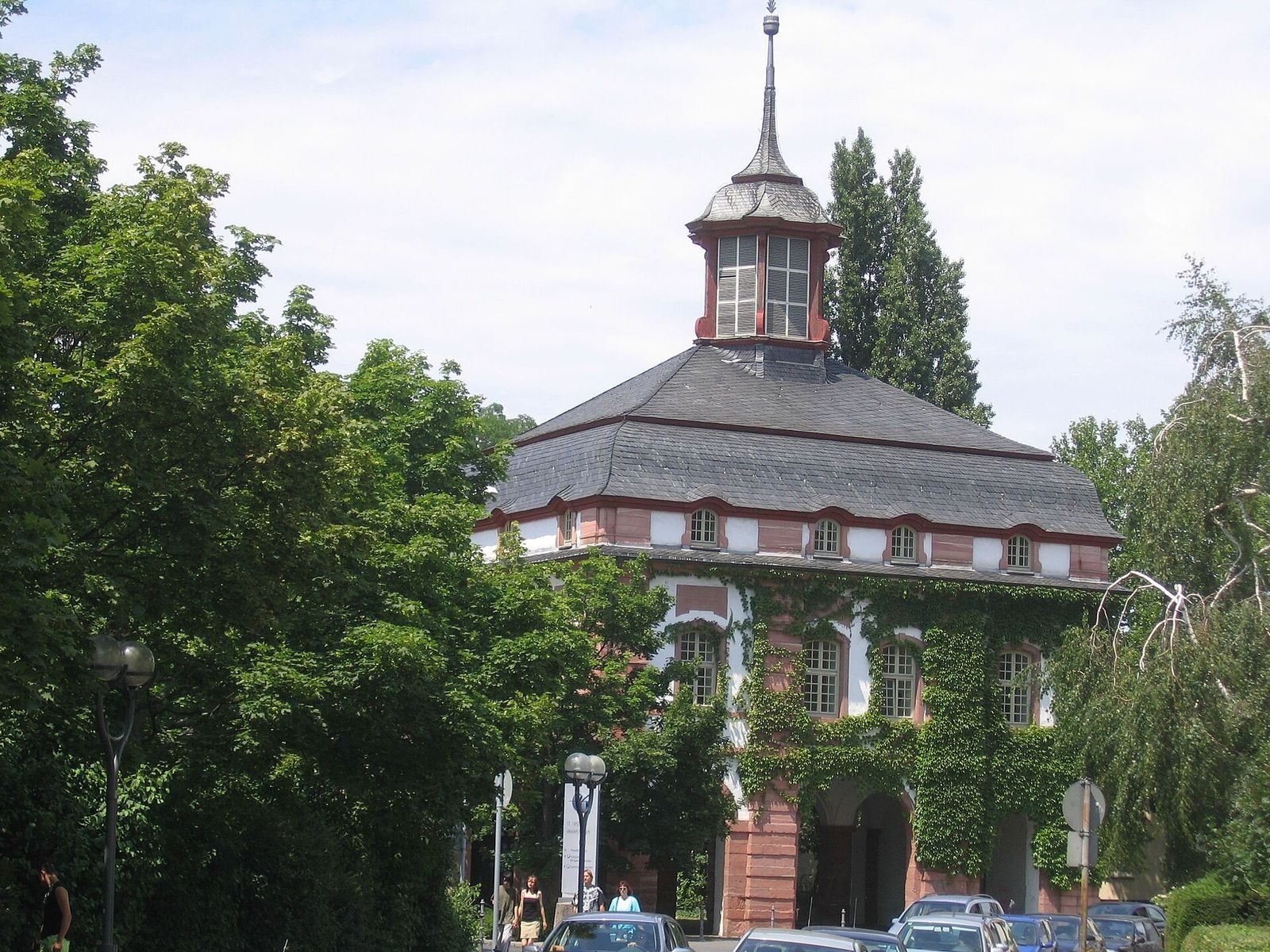
The first Frankfurt Gate was built between 1601 and 1607 and partly collapsed during construction after a flood. Count Johann Reinhard III commissioned a grander rebuilding in 1722. The gate bears the arms of the count and his wife, Dorothea Friederike of Brandenburg-Ansbach. Of its three outward-facing arches, only the middle one was initially open, while all three opened toward the town. The county mint was housed there for a time.
The Frankfurt Gate is the only gate to survive. It escaped the Napoleonic demolition because it contained apartments, but was destroyed down to its enclosing walls and passage vaults in 1945. It was rebuilt in 1953–55 and later plastered. A short section of the adjoining Neustadt wall also remains.
The Mühl and Red gates
The Mühl Gate was built after 1609. It closed during the Thirty Years’ War, and its bridge was later dismantled. The gate itself was removed during the Napoleonic demolition. The Red Gate, also called the Wall Gate or Red House Gate, provided a secondary exit toward the Kinzig mills, Jewish cemetery, and Rückingen. Its construction began in 1535 and was completed in 1615; it was removed during the same demolition campaign.
Waterways and surviving lines
The Kinzig curves around the old town before flowing southwest toward the Main, leaving Hanau’s central area bordered by water on three sides. The defensive moats were supplied by the river. The only surviving moat is the channel that branches from the Kinzig at Herrnmühle and passes through Schlossgarten. A short section of the Main Canal also remains. Built around 1600, it ran from a point upstream of the Kinzig’s mouth toward a harbor near today’s Kanaltorplatz.
Several streets preserve the broad course of the Neustadt moat and rampart on the west, south, and east sides of the former town. These alignments include parts of Mühltorweg, Julius-Leber-Straße, and Grüner Weg, as well as sections near Kanaltorplatz. Bridge traces also survive along the inner city ring: an old railing marks a former crossing at Heinrich-Bott-Straße, and a separate bridge over the former moat remains at Nussallee 16.