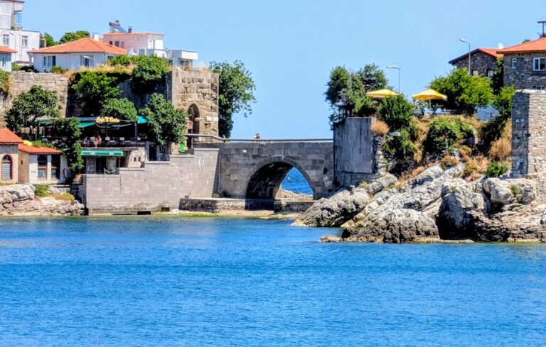
Safranbolu: A Preserved Ottoman Historic Town in Türkiye

Site at a Glance
- Rating
- 4.7
- Popularity
- Medium
- Country
- Turkey
- Primary era
- Early Modern
- Eras represented
- Bronze Age, Medieval, Early Modern, Modern
- Civilizations
- Byzantine, Hittite, Ottoman, Seljuk
- Site type
- City
On this page20 sections
History
Safranbolu is a historic town in Türkiye whose settlement history reaches back to ancient Paphlagonia, a region of northern Anatolia along the southern Black Sea coast. Its preserved urban form developed through successive periods of Anatolian and Ottoman history, with the town reaching a cultural and economic high point in the seventeenth century. Its location on East-West caravan routes helped make it a centre of trade, accommodation, and craft production, while its surviving townscape later earned inscription on the UNESCO World Heritage List in 1994.
Ancient and Medieval Settlement
Human occupation in the surrounding region extends at least to the third millennium BC. Tumuli dated broadly to 3000–4000 BC attest to early settlement, and Safranbolu has been associated with ancient places known by names including Flaviopolis, Theodoroupolis, Hadrianopolis, Germia, and Dadybra. The area passed successively under the control of the Gasgas and Zalpa peoples, the Hittites, Phrygians, Lydians, Persian rulers, Hellenistic kingdoms, Rome, and Byzantium.
The town had several names over time, including Dadybra or Dadibra, Theodoroupolis, Saphrampolis, Zalifre, Taraklıborlu, Zağfiranpolis, and Zafranbolu. The origin of Safranbolu remains uncertain. One explanation connects the name with saffron cultivation and the Greek word for “city,” while another derives it from earlier place-names without linking it to saffron.
Then known as Dadybra, the town came under Turkish rule in 1196 through Muhiddin Mesut Shah, the son of Seljuk Sultan Kilij Arslan II. The circumstances are described in differing ways: Muhiddin Mesut Shah reportedly promised to spare the inhabitants if they surrendered peacefully, while records also state that the city was captured by force. The fate of its Christian population is not recorded.
Seljuk and Anatolian Principalities
Under Seljuk rule the town was called Zalifre and formed part of a frontier zone extending between Sinop, Kastamonu, Safranbolu, Gerede, and Söğüt. Ottoman attempts to settle Türkmen nomads in the area contributed to later names such as Taraklı Borglu, Borglu, and Borlu.
Safranbolu was administered by the Chobanids from 1213 to 1280 and by the Jandarids from 1326 to 1354. These were medieval Anatolian principalities that controlled parts of northern Anatolia during the decline of Seljuk power and before the expansion of the Ottoman state. The town first came under Ottoman control in the mid-fourteenth century, but remained a frontier settlement between the Ottomans and Jandarids until its incorporation into the Ottoman state in the early fifteenth century.
The Gazi Süleyman Pasha Mosque was already in use during the Jandarid period, when Islamic architectural activity increased in the town. In 1332, the Moroccan traveler Ibn Battuta visited Safranbolu while travelling toward Kastamonu. He met Ali Bey, the governor and son of the Kastamonu pasha, and described a madrasa, an institution for religious and sometimes broader scholarly instruction, where the Hanafi teaching tradition was followed.
Safranbolu is also described as having resisted a four-month siege by Ottoman Sultan Suleiman II, who ruled from 1687 to 1691. The siege allegedly involved the destruction of houses and the poisoning of the water supply. Famine eventually led the inhabitants to negotiate a surrender under terms that allowed them to leave undisturbed.
Caravan Trade and Ottoman Prosperity
From the thirteenth century until the arrival of the railway in the early twentieth century, Safranbolu served as an important station on the East-West caravan route. A caravanserai was a fortified roadside establishment where merchants, animals, and goods could receive lodging and protection. Safranbolu’s connections with Istanbul, Sinop, Kastamonu, Gerede, and the wider Ottoman trade network supported commerce, accommodation, and craft production.
The town reached its cultural and economic apogee in the seventeenth century. Its architecture influenced urban development across a substantial part of the Ottoman Empire, and palace and state officials sponsored important buildings, including the Cinci caravanserai and bath. The period established much of the architectural character for which the historic town is known.
Late Ottoman and Republican Transformations
During the late Ottoman period, Safranbolu was a multi-ethnic and multi-religious settlement. The Ottoman census of 1881–1893 recorded 52,523 people in the district, including 49,197 Muslims and 3,326 Greeks. The town contained mosques, Greek Orthodox churches, tekkes, schools, madrasas, libraries, baths, inns, shops, and a hospital. Kıranköy was the principal Greek Orthodox quarter before the 1923 population exchange, after which the Greek Orthodox population was transferred to Greece. The population then fell from approximately 7,500 in the late nineteenth century to about 5,000.
Safranbolu became the centre of its district during nineteenth-century Ottoman administrative reforms and was attached to Kastamonu Province. It was transferred to Zonguldak Province in 1926 and became part of Karabük Province when Karabük became a province in 1995.
The opening of the Karabük Iron and Steel Works in 1939 shifted the region’s economic centre toward Karabük. Workers, artisans, and farmers moved to the new industrial centre, while Safranbolu’s historic urban fabric remained comparatively little affected by the modernization and urbanization of the 1950s. The decline of caravan trade and the growth of the steel industry gave the town a new socioeconomic role without eliminating its historic form.
Conservation and World Heritage
From the 1970s, tourism brought renewed economic activity. Vacant historic houses were adapted as hotels and restaurants, and traditional crafts began to revive. Safranbolu was declared an urban conservation area in 1975. In 1994, its historic city was inscribed on the UNESCO World Heritage List under criteria (ii), (iv), and (v), recognizing its influence on Ottoman urban architecture, its representative historic townscape, and the relationship between settlement and topography. The World Heritage property covers 193 hectares.
The historic areas are protected as urban and natural sites under Turkey’s National Conservation Law No. 2863. Safranbolu Municipality manages the historic areas, while changes to registered buildings and conservation areas require approval from the Regional Conservation Council. A conservation plan established restoration standards, and a buffer zone was approved in 2008. Municipal institutions, a university, nongovernmental organizations, an architecture faculty, and a vocational school specializing in restoration have supported conservation, maintenance, restoration, and public-awareness work.
Modern reuse has helped preserve vacant historic buildings, but tourism and changing economic conditions have also placed pressure on authenticity. Inappropriate tourism practices, the growth of souvenir shops in the Çarşı area, the declining number of experienced restoration craftsmen, and deterioration of traditional houses remain conservation concerns.
Remains
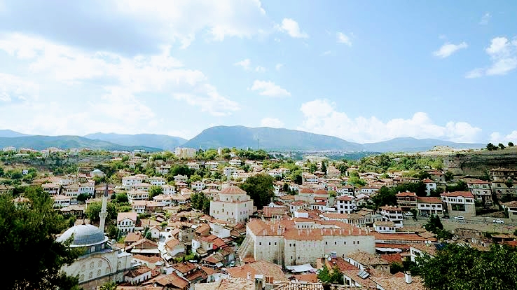
Safranbolu’s historic city is organized into three districts whose relationship with the terrain remains largely intact. Çukur occupies the lower town in a deep ravine, Kıranköy forms the former non-Muslim quarter, and Bağlar, or the Vineyards, spreads across the northwestern slope. Narrow streets, traditional houses, religious buildings, commercial structures, bridges, waterworks, and archaeological remains together preserve the physical structure of the historic settlement.
Historic Districts and Streets
Çukur
Çukur has a triangular plan defined by two rivers. Its market centre is surrounded by craftsmen’s houses and workshops, and the district occupies the lower part of the town. The streets are narrow and curved to follow the topography. Their inward-sloping stone paving carried surface water away, while projecting house consoles created changing perspectives at street corners.
Kıranköy
Kıranköy has a different socio-architectural pattern from Çukur. Its stone buildings traditionally placed shops on the lower level and residences above, reflecting the district’s historic role as the principal Greek Orthodox quarter. Its streets share the narrow, curved alignment shaped by the hillside and valley terrain.
Bağlar
Bağlar consists principally of detached houses set within large gardens, vineyards, and fruit orchards on the northwestern slope. Facing south, it historically served as Safranbolu’s summer district. Residents preferred the lower Çarşı area during winter because it was milder and more sheltered from wind. A Seljuk fortress stands on the hill above the town, and the upper district developed around this elevated fortified area, with loosely spaced houses that served as summer villas for residents of the old town.
Traditional Houses and Domestic Interiors
The historic settlement contains approximately 2,000 traditional buildings, including 1,008 registered and legally protected structures. Traditional houses are generally three storeys high. Their ground floors are built of stone, while the two upper floors use plastered timber framing divided into relatively narrow bays. In many houses, street-facing walls have no windows and resemble extensions of garden walls.
Inside, principal rooms commonly contain panelled surfaces, built-in cupboards, fireplaces, shelves, and benches. Many ceilings are carved and painted. The rooms connect through sofas, halls or circulation spaces that organize the domestic plan. Some houses also contain rectangular water basins or pools, including a pool room in Asmazlar Mansion. Modern adaptations have changed some interiors, while allowing vacant houses to continue in use as hotels, restaurants, and other tourism-related buildings.
Commercial Buildings and Waterworks
Cinci Han
Cinci Han is a seventeenth-century caravanserai associated with Safranbolu’s role in caravan trade. Its fortress-like exterior has narrow windows and loopholes. Inside, a large courtyard is enclosed by two levels of arcaded galleries, with a fountain at the centre. The building also contains a large ground-floor hall for pack animals, former merchants’ rooms, and a tower above its single gate that housed the administrator.
Cinci Hamam
The Cinci Hamam is a seventeenth-century Turkish bath, or hamam, that operated with the caravanserai during Safranbolu’s period of commercial prosperity. Together with the Cinci Han, it represents the buildings associated with the town’s caravan economy.
Incekaya Aqueduct
The Incekaya aqueduct, also called the Inceköprü or Safranbolu aqueduct, crosses a stream in a deep valley. It forms part of the historic water infrastructure associated with the town’s wider landscape.
Religious and Civic Buildings
Early Islamic Buildings
The Old Mosque, Old Bath, and Süleyman Pasha Madrasa date from 1322. The Gazi Süleyman Pasha Mosque was already functioning during the Jandarid period. These buildings belong to the medieval phase when Islamic institutions and architecture became more firmly established in Safranbolu.
Ottoman Mosques and Memorials
The Köprülü Mehmet Pasha Mosque was founded by Grand Vizier Mehmed Köprülü, who held office from 1656 to 1661. A Roman sundial stands in its courtyard. The İzzet Mehmet Pasha Mosque dates from the late eighteenth century and was founded by İzzet Mehmet Pasha, a Safranbolu-born grand vizier who served from 1794 to 1798. Its interior decoration has been described as resembling Central European Rococo, and its adjoining complex includes a library. The founder’s sarcophagus-shaped tomb monument stands in the courtyard.
The Dağdelen Mosque also dates from the eighteenth century. The Kalpak, or Lütfiye, Mosque was built in the nineteenth century on an arch spanning the Safranbolu River. A nineteenth-century Classical-style palace, formerly used as the town hall, now functions as the city museum. A former Greek town hall is also among the historic buildings.
Archaeological Features and Historic Inventory
The registered historic inventory includes hundreds of houses and mansions, one private museum, 25 mosques, five tombs, eight historic fountains, five baths, three caravanserais, a historic clock tower, and a sundial. Other remains include mounds of ancient settlements, rock-cut tombs, historic bridges, and the remains of an earlier Byzantine church. Together, these features extend the history of the town beyond its Ottoman houses and commercial buildings.
The external form of the settlement and its three-part organization remain substantially preserved, retaining the historic street layout and general townscape of pre-industrial Turkey. Individual interiors have been altered in response to modern needs and industrialization, but the relationship between the districts, the buildings, and the surrounding topography continues to define Safranbolu’s historic character.