Saalburg: A Roman Frontier Fort and Archaeological Museum in Germany



Site at a Glance
- Rating
- 4.6
- Popularity
- Medium
- Country
- Germany
- Primary era
- Classical
- External website
- Open
- Eras represented
- Classical, Modern
- Civilizations
- German, Roman
- Site type
- Military
- Remains
- Fort
On this page20 sections
History
Saalburg is a Roman frontier fort and archaeological site in Germany, near Bad Homburg vor der Höhe, built on a strategic pass across the Taunus ridge. Roman troops probably fortified the pass during Emperor Domitian’s wars against the Chatti, between AD 83 and 85, creating two simple earthwork enclosures. The site later developed into a major fort on the Upper Germanic-Raetian Limes, the Roman frontier system of roads, ditches, banks, palisades, watchtowers, and forts in the German provinces.
Early earthwork enclosures
The northern enclosure, Schanze A, may have been established under Domitian, although an earlier foundation during the reign of Vespasian cannot be ruled out. Schanze B was built later and appears to have been intended for a longer occupation. Each installation probably held a detachment roughly equivalent to a century, or about 80 soldiers. Their position allowed Roman forces to control movement through the pass between the Rhine–Main plain, the Usingen basin, and the Germanic settlement zone.
A rectangular wood-and-earth fort for a numerus, a small auxiliary military unit, was built near the earlier enclosures around AD 90. Its garrison may have been a Numerus Brittonum, a unit originally recruited in Britain, although that identification remains uncertain. The fort was occupied until the middle of the second century. Around AD 135, it was deliberately dismantled and levelled during a reorganization of the frontier under Emperor Hadrian.
The cohort fort
The numerus fort was replaced around AD 135 by a 3.2-hectare cohort fort. A cohort was a larger auxiliary formation, normally composed chiefly of infantry, although the unit at Saalburg also included mounted troops. The new fort was turned toward the south, facing Nida, the principal settlement of the Civitas Taunensium, rather than toward the Limes to the north. This change reflected the fort’s relationship with the settlement and the wider road network.
The garrison was the Cohors II Raetorum civium Romanorum equitata, a partially mounted auxiliary unit of about 500 men. Before arriving at Saalburg, it had been stationed at Aquae Mattiacorum, modern Wiesbaden, and at Butzbach. It probably came under the authority of the legionary headquarters at Mogontiacum, modern Mainz. Inscriptions from the site name the unit and some of its commanders.
The fort remained in use until the collapse of the Upper Germanic Limes around AD 260. Emperor Caracalla’s campaign against the Alamanni and their Chatti allies in AD 213 temporarily reduced pressure on the frontier, but further incursions followed around AD 233, 254, and 260. Saalburg appears to have been deliberately evacuated without a battle when Roman territory east of the Rhine was abandoned.
The civilian settlement and cemeteries
A vicus, the civilian settlement associated with a fort, grew beside the military installations. Its first phase began with the numerus fort around AD 90. A second phase followed the construction of the cohort fort around AD 135, while a third phase, dating from about AD 155 or 160 to about AD 233, brought a new road system and a reorganization of property plots and buildings.
Part of the earlier settlement was deliberately burned to make room for the cohort fort. The later vicus eventually covered about 13 hectares and reached its largest population in the early third century. It served the military community with commercial and residential buildings, bathing facilities, and official travel accommodation along the road to Nida. The combined fort and settlement may at times have housed as many as 2,000 people, including approximately 500 soldiers and 1,500 civilians.
A major fire struck the vicus during the first half of the third century, probably between AD 225 and 248. Its cause remains uncertain because the destruction does not provide clear evidence of combat. Afterward, the settlement declined. Houses were abandoned, while wells and cellars were filled.
The largest cemetery lay south of the fort and vicus, on both sides of the road to Nida. The burials were cremations, commonly accompanied by pottery vessels, an oil lamp, and a coin. Some graves also contained glass or bronze objects and terracotta figures. An older cemetery in the vicus area was used mainly during the period of the numerus fort and was gradually built over after the cohort fort was established. A younger cemetery south of the settlement served both soldiers and civilians from approximately the middle of the second century to the middle of the third century.
Rediscovery and reconstruction
After the Roman withdrawal, the fort deteriorated and its masonry was quarried during the Middle Ages and the early modern period. Stone from the ruins was used in construction at Thron Monastery near Wehrheim. Elias Neuhof recognized the Roman origin of the remains in 1747, but stone robbing continued until protective measures were introduced in the nineteenth century. An order issued by Landgrave Friedrich V of Hesse-Homburg ended the quarrying in 1818, and Landgrave Friedrich VI acquired the site in 1820.
Friedrich Gustav Habel received permission to investigate Saalburg in 1841, and the Nassau Antiquarian Society directed excavations from 1853 to 1862. A Saalburg commission later concentrated on preservation, while Karl August von Cohausen led excavations from 1870. The Saalburg Association, founded in 1872, supported further excavation and the creation of a museum.
Louis Jacobi increasingly took over excavation leadership during the 1870s. From 1892, he and his son Heinrich served as commissioners for the Reich-Limeskommission, the imperial commission that systematically investigated the Roman frontier and its forts in Germany. Excavations at Saalburg and in the surrounding area intensified within this wider project.
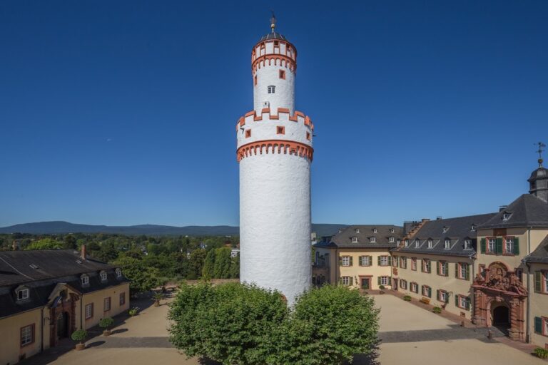
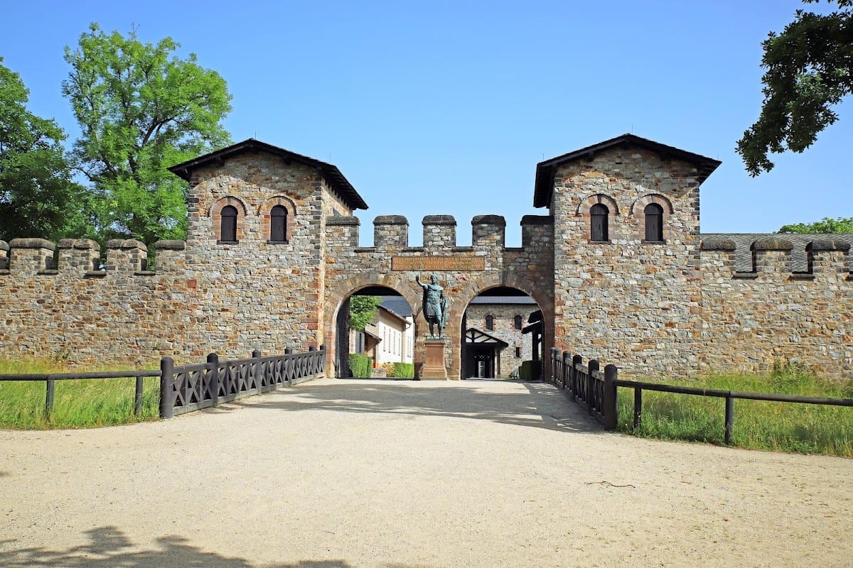
At Louis Jacobi’s suggestion, Kaiser Wilhelm II ordered the reconstruction of the fort in 1897. Work had already begun at the southwest corner of the defensive wall in 1885. The foundation stone for the main reconstruction was laid on 11 October 1900, and the principal works continued until about 1907. The reconstructed complex was intended to present an approximately faithful Roman fort and became the most completely reconstructed fort on the Limes.
The reconstruction also housed the Saalburg Museum and a research institute. Its appearance is not wholly accurate in every detail. The visible battlements have narrower spacing than the excavated remains indicate because Wilhelm II required the alteration. The reconstructed courtyard of the Principia, the central headquarters building of a Roman fort, is probably shown as open even though it may originally have been roofed.
Research centre and heritage site
Heinrich Jacobi directed the museum from 1912 to 1936 and again from 1945 to 1946. After the Second World War, operations were disrupted when the buildings were used to store material from the Oberursel Motor Works, and looting occurred during the final days of the war. Ferdinand Kutsch directed the museum provisionally in 1947 and 1948, followed by Hans Schönberger from 1948.
Under Schönberger, Saalburg developed into an important research centre for the Limes and provincial Roman archaeology. The museum undertook excavations at the forts of Echzell, Altenstadt, and Heilbronn-Böckingen, and hosted the Sixth International Limes Congress in 1964. Dietwulf Baatz directed the museum from 1967 to 1993, Egon Schallmayer from 1995 to 2013, and Carsten Amrhein became director in 2013.
Since 2005, Saalburg has formed part of the UNESCO World Heritage property comprising the Upper Germanic-Raetian Limes. The site and surrounding Limes installations are also protected archaeological monuments under Hessian monument-protection law. A programme connected with the World Heritage nomination created an archaeological park and fundamentally restored the surviving reconstruction fabric, with the construction and restoration measures completed in 2014.
Saalburg is one of Hesse’s archaeological state museums and belongs to hessenARCHAEOLOGIE, a department of the Hessian State Office for Monument Preservation. Its research centre specializes in provincial Roman archaeology and the Limes, and the site houses the office of the German Limes Commission, founded in 2003. The Saalburg Yearbook has appeared, with interruptions, since 1910, while the Saalburg Writings have been published since 1995.
Remains
Saalburg lies at approximately 418 metres above sea level on the main Taunus ridge, immediately west of the modern Bundesstraße 456. The surviving archaeological complex includes the remains and reconstruction of successive Roman forts, the civilian settlement south of the fort, cemeteries, and sections of the nearby frontier line. The reconstructed fort contains the Saalburg Museum, with exhibition areas in the Horreum, or grain store, the Principia, and the Fabrica, a reconstructed workshop building.
Early earthworks and the numerus fort
Schanze A
Schanze A was an irregular pentagonal earthwork with a bevelled northeast side. It measured about 42 by 38.5 metres and covered nearly 1,600 square metres, with approximately 1,200 square metres of usable interior space. A single ditch, 1.50 to 1.80 metres wide and 0.80 to 0.90 metres deep, surrounded the enclosure and was interrupted at the south gate. The rampart carried a wattle fence strengthened with earth from the ditch, without a rear walkway.
The western three-quarters probably held up to ten troop tents and a commander’s tent. The eastern quarter may have been used for pack and riding animals, with feeding and drainage channels in this area. Several ovens occupied the northwest corner. Traces of another wattle enclosure outside the ditch may belong to an earlier temporary camp.
Schanze B
Schanze B stood about 28.5 metres south of Schanze A. Its nearly square plan measured approximately 44 by 46 metres and covered just over 2,000 square metres, although the usable interior was only about 17 by 19 metres. Two pointed ditches, each about 2.80 metres wide and 1.20 metres deep, enclosed it. A narrow central trench probably held an additional wattle fence.
The rampart supported a wattle parapet and a rear walkway. Its single north-facing gate, directed toward the Limes, was about five metres wide and may have carried a tower-like upper structure. A road ran between the rampart and the interior buildings, which probably formed a U-shaped arrangement opening toward the gate. The wings may have contained contubernia, shared rooms for groups of soldiers, while a centurion’s rooms occupied the rear.
The numerus fort
The rectangular numerus fort measured approximately 84.4 metres from north to south and 79.8 metres from east to west, covering slightly more than 6,700 square metres. Its rounded defensive rampart consisted of an earth bank strengthened by timber posts on the inside and turf and wattle on the outside. Much of the earth came from a surrounding fossa punica, a broad pointed ditch about two metres deep and five to six metres wide. A drainage channel along the bottom was at least partly lined with wooden boards, while a berm 0.60 to 0.70 metres wide separated the ditch from the rampart.
Postholes identify four corner towers and two towers along the sides. Two gates, each 3.60 metres wide, opened to the north and south. The northern gate faced the Limes, and its ditch was interrupted by an earth bridge protected by a titulum, a short defensive bank placed outside a gate. The southern ditch narrowed but remained continuous. Inside the rampart, a roughly three-metre-wide road ran around the fort, separated from the buildings by a timber-lined and boarded drain. Post patterns indicate barracks in the eastern rear sector, while hearths point to additional timber structures.
A paved central area may have been a shrine for the military standards or a tribunal, a raised place for official proceedings, but neither interpretation is certain. A water basin 1.50 metres deep and measuring 3.90 by 4.50 metres had a five-step stairway, although its function is also uncertain. Outside the north-northeastern side stood a block-type bath. Its eastern half contained a changing room and cold room, while the western half held warm and hot rooms with a furnace.
The cohort fort
The wood-and-stone fort
The first cohort fort, commonly called the wood-and-stone fort, covered approximately 3.2 hectares. Its defensive wall used two parallel dry-stone walls, each about 0.8 metres wide and set 2.3 metres apart. The space between them was filled with earth and rubble and reinforced by regularly spaced timber beams measuring about 20 by 50 centimetres.
The fort probably had a covered walkway, a three-metre berm, and an eight-metre-wide pointed ditch. It lacked an internal earth ramp and was reached by 24 narrow ramps. Nineteen ovens, each approximately 1.5 to 1.8 metres in diameter, stood along the inner side of the wall. Wooden towers are now considered likely, although earlier reconstruction work did not include them.
The final stone enclosure
The final stone fort represented an expansion of the earlier installation rather than an entirely new foundation. Its rectangular enclosure measured approximately 147 by 221 metres and covered about 3.25 hectares. A mortared stone wall with rounded corners surrounded the fort. It had four gates, each flanked by two towers, but no corner towers. The outer face was plastered and painted to imitate rectangular ashlar masonry.
An earthen ramp ran along the inside of the wall and gave access to the defensive walkway. The wall foundation narrowed in steps from approximately 2.10 to 1.80 metres. Excavated remains stood up to about 2.40 metres high, while the original wall may have reached roughly 4.80 metres. The original battlements were spaced 1.50 metres apart. Beyond a berm about 0.90 metres wide lay a double pointed ditch. The inner ditch was about three metres deep and 8.00 to 8.75 metres wide, while the outer ditch was 2.5 to three metres deep and nearly ten metres wide. Earth or wooden bridges provided access at the gates.
The south-facing porta praetoria, or main gate, had two passageways, each 3.36 metres wide, divided by a central pier. The rear gate had one passage 2.8 metres wide, while the two side gates measured approximately 3.66 and 3.77 metres. The main gate’s orientation toward Nida, rather than toward the Limes, distinguishes this fort from the earlier installations.
Headquarters and internal buildings
A road about three metres wide encircled the interior behind the defensive wall and was accompanied by a drainage channel. At the centre stood the Principia, the headquarters building containing administrative rooms, an assembly area, and the shrine for the military standards. The building measured approximately 41 by 58 metres and included a covered transverse hall about 38.5 by 11.5 metres.
The hall had foundations 0.85 to 0.95 metres wide. It could be entered through a main doorway aligned with the principal road or through two side entrances aligned with the cross street. Five further doorways led into an inner courtyard surrounded by a portico. Two wells and a feature measuring 5.2 by 5.2 metres occupied the courtyard. The headquarters contained the aedes, the standards shrine, while fragments of an armour-clad statue from the hall probably belonged to an imperial statue of the early third century. The courtyard in the present reconstruction may be inaccurate because it was probably roofed originally.
The commander’s residence, the Praetorium, stood west of the main road in the front part of the fort. To the east was the large Horreum, a grain store that now contains museum exhibition rooms. The other interior areas held barracks, stables, magazines, and workshops. Two troop barracks with shared soldiers’ rooms have been reconstructed in the southeast, while the Praetorium is only partly reconstructed.
Bath and official lodging
The cohort fort’s bath stood outside the main gate, west of the road to Nida. It began as a row-type bath in which heated and cold rooms followed one another. The complex included a changing room, a cold room with a pool, two warm rooms, a sweating room, and a hot room with apses and pools. A separate large pool and a western furnace completed the arrangement.
The bath was altered several times. A large transverse hall, probably another changing room, was added and later demolished. A heated winter changing room and a latrine were subsequently inserted. A hypocaust, a Roman underfloor and wall-heating system supplied by a furnace, warmed the relevant rooms. Stamped tiles associate successive building phases with Legio VIII Augusta, Legio XXII Primigenia, the Cohors II Raetorum, and the Cohors IV Vindelicorum.
Immediately southeast of the bath, beside the southern road, stood a large building probably serving as a mansio, an official lodging and relay station. At least its southern rooms were heated and arranged around a courtyard used by vehicles and animals. It was probably built during the second half of the second century, after part of the bath’s changing hall had been demolished, and ceased to be used during the fort’s late period.
Vicus and cemeteries
The civilian settlement
The vicus extended mainly south of the fort on both sides of the road to Nida. Its conserved remains include foundations and cellars of residential buildings, the mansio, the soldiers’ bath, a taberna, or shop, and a structure once interpreted as a shrine to Mithras. That identification is no longer generally accepted, and the feature is now regarded as a grave enclosure.
The first settlement phase, from about AD 90 to 135, is represented chiefly by wells, one building, and property boundaries aligned along a road running from the fort toward the south-southeast. The second phase, dated to about AD 135 to 155 or 160, included the bath complex and the adjacent shop. The third phase followed a newly arranged network of roads and property plots and lasted from about AD 155 or 160 to about AD 233.
Burial areas
The older cemetery within the settlement area consisted of two burial groups separated by a strip about 30 metres wide. The northern group contained approximately 50 graves, most excavated in 1909. The southern group held about 40 graves, of which 13 were securely documented. Coins of Hadrian and Trajan, together with several forms of Terra Sigillata, place both groups in the first half of the second century.
The younger cemetery south of the vicus contained about 300 cremation burials. Dating evidence includes an as of Antoninus Pius struck in AD 140 to 144, a coin of Septimius Severus, a denarius of Julia Maesa, and third-century potters’ stamps. Grave goods included ceramic vessels, oil lamps, coins, glass, bronze objects, terracotta figures, and a Germanic sword.
At the southern edge of the settlement, a feature once reconstructed as a Mithraeum, a shrine of the mystery cult of Mithras, stood beside a spring. In 1872, 33 cremation burials were recovered between two parallel walls. A denarius of Julia Maesa, a Niederbieber 27 Terra Sigillata jug, and a Germanic sword indicate that burials took place there during the first half of the third century. The reconstructed Graves House, built by the Saalburg Association in 1872, stands within the cemetery area and was designed to house grave goods and demonstrate the proposed architectural character of the reconstructed fort.
The nearby Limes
About 200 metres north of the rear gate, the Limes follows an east–west course. A section of its ditch, bank, and palisade survives or has been reconstructed in the landscape. This part of the frontier ran between the small forts at Heidenstock to the southwest and Lochmühle to the northeast.
A stone watchtower on the route toward Lochmühle had a roughly square plan measuring 6.35 to 6.55 metres per side, with walls about 0.60 metres thick. A wooden tower stood approximately 0.90 metres west of it, identified by a ditch 1.90 metres wide and 0.60 metres deep. Another wooden tower stood immediately east of the stone tower. A coin of Caracalla was found between the stone tower and the western wooden tower.
Near Saalburg stands a reconstructed copy of the Mainz Jupiter Column, a sandstone monument about 12 metres high. Sculptor Eduard Schmahl completed the copy in 1912, and it was conserved between 2011 and 2014. The museum within the reconstructed fort displays military and domestic equipment, architectural and topographic models, and material from Saalburg and other regional sites. Its specialist library contains approximately 30,000 books and 2,200 slides.