Rujm el-Hiri: An Ancient Megalithic Monument in Israel
Site at a Glance
- Rating
- 4.5
- Popularity
- Low
- Country
- Israel
- Primary era
- Bronze Age
- Eras represented
- Bronze Age
- Civilizations
- Unclassified
- Site type
- Religious
- Remains
- Sanctuary
On this page11 sections
History
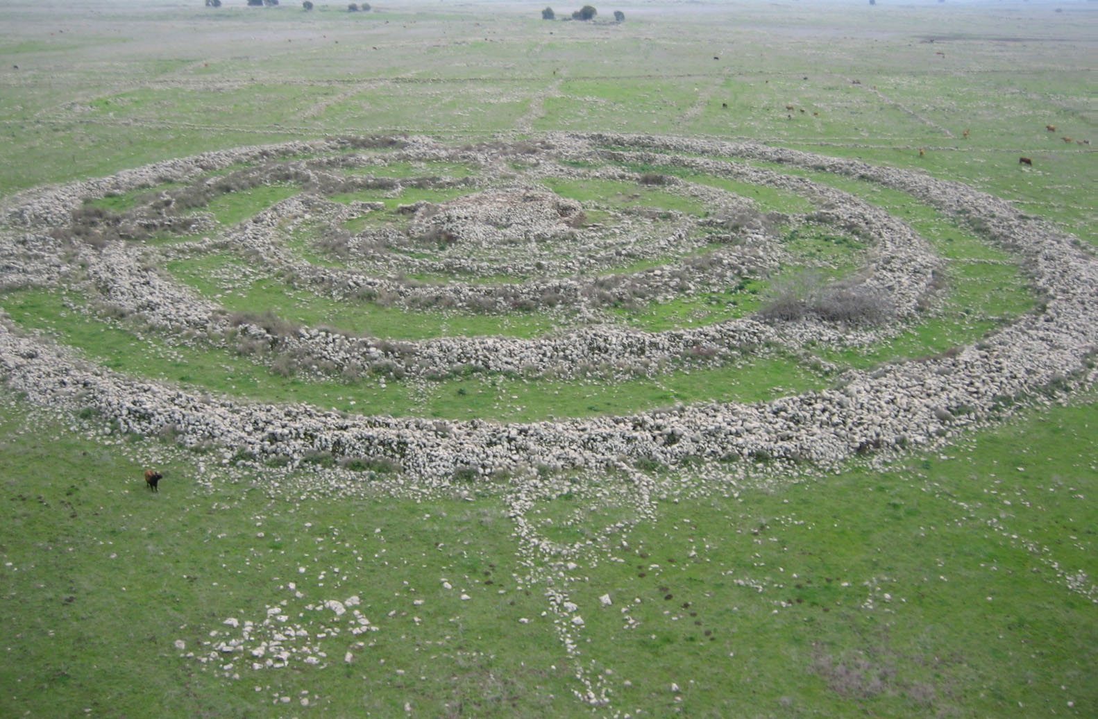
Rujm el-Hiri is an ancient megalithic monument and geoglyph in Israel’s Golan Heights, about 16 kilometres east of the Sea of Galilee. Built during the Early Bronze Age, probably in Early Bronze Age II between approximately 3000 and 2700 BCE, it forms a vast circular design on a broad plateau near an ancient settlement and hundreds of dolmens, which are stone tombs made from upright supports and horizontal slabs.
Early Bronze Age construction
The monument’s builders arranged more than 42,000 basalt stones in concentric circles around a central mound. Its scale and carefully organized layout indicate a substantial communal undertaking, although the original purpose remains uncertain. Proposed explanations include a ritual centre, a burial place, a calendar, a location for astronomical observation, and a site where the dead were exposed. The available evidence has also led archaeologists to argue that it was not a residential quarter or a defensive position.
One interpretation connected ceremonies at Rujm el-Hiri with the summer and winter solstices, perhaps in honour of Tammuz and Ishtar, ancient Near Eastern deities associated with fertility, seasonal change, and agricultural renewal. A 2024 study rejected the proposed alignments with the solstices and equinoxes. That conclusion weakened explanations based on deliberate astronomical orientation, although it did not resolve the monument’s original function.
Burial interpretations and later use
The central tomb was traditionally understood as a later addition, approximately a millennium after the surrounding circles, during the second millennium BCE. It has been interpreted as a burial place for leaders or other important people. Jewellery and other valuable objects, together with clothing remains and weapons, supported a funerary interpretation, while the tomb had also been looted.
Michael Freikman proposed a different chronology, suggesting that the tomb may have been built at the same time as the stone circles. A Chalcolithic, or Copper Age, pin found in a passageway formed part of the basis for this view. Archaeologist Rami Arav compared the monument’s possible function with a dakhma, or tower of silence, where bodies were traditionally exposed so birds could remove the flesh. Other interpretations connect the site with a cult of the dead.
After the communities that created the monument changed, Rujm el-Hiri apparently declined in importance. It may later have served as a military lookout, an observation point, or a sheep enclosure, but these proposed functions remain uncertain. Traditions have also linked it with giants, Og, the king of Bashan, Goliath, and the biblical stone monument of Gilead. These associations belong to later legend rather than established explanations of the monument’s origins.
Rediscovery and archaeological investigation
The monument became known to Israeli researchers after the 1967 war and the Israeli occupation of the Golan Heights. Its Arabic name, Rujm el-Hiri, meaning “stone heap of the wildcat,” survived on older Syrian maps. A Syrian triangulation point was found on the central cairn. The alternative name Gilgal Refaim means “Wheel of Spirits” or “Wheel of Ghosts” and refers to the biblical Rephaim, traditionally associated with the ancient inhabitants or giants of Bashan, a region broadly corresponding to the modern Golan Heights.
Shmarya Guttman and Claire Epstein recorded the monument during the first archaeological survey of the Golan Heights after 1967, conducted from September 1967 to February 1968. Yitzhaki Gal recognized its circular arrangement from an aerial photograph. Serious professional excavations began in the 1980s under Moshe Kochavi and Yoni Mizrachi as part of the Land of Geshur Archaeological Project.
Further excavation and research took place in 2007 through work by Yosef Garfinkel and Michael Freikman of the Hebrew University of Jerusalem. Freikman returned in 2010 to examine the monument’s date and function. Satellite-image research carried out between 2004 and 2024 identified 28 additional stone circles within 25 kilometres of Rujm el-Hiri, expanding the known landscape of comparable stone monuments beyond the features identified through archaeological surveys.
Remains
Rujm el-Hiri occupies a broad, slightly oval enclosure built from partly worked basalt, a volcanic stone widely available in the Golan Heights. Four principal circular walls surround a central tumulus, or mound of earth or stone that may cover a burial chamber. Smaller irregular walls run between the main circles, joining sections of the enclosure. The overall design is difficult to grasp from ground level and is most clearly understood from above.
Concentric stone enclosure
Outer walls and connecting structures
The outer enclosure measures approximately 150 to 160 metres across. Its largest wall is about 3.2 metres wide and reaches approximately 2.4 metres in height in one description. The circumference approaches half a kilometre. The four main walls contain roughly 12,000 cubic metres of basalt, with an estimated total mass exceeding 37,000 tonnes. Another estimate places the mass of the partly worked stone between 37,500 and 40,000 tonnes. The stones were stacked to heights of up to about 2 metres, and Michael Freikman estimated that their transport and construction required more than 25,000 working days.
The innermost wall is an incomplete semicircle approximately 50 metres in diameter and 1.5 metres wide. It connects with a nearly complete second circle about 90 metres across. A third wall forms a complete circle approximately 110 metres in diameter and 2.6 metres wide. The fourth wall, which forms the outer boundary, is about 150 metres in diameter and 3.2 metres wide. Smaller walls cross the spaces between these circles, running perpendicular to the principal rings and linking parts of the enclosure.
Entrances and eastern stones
Two major openings face northeast and southeast. The northeastern entrance is about 29 metres wide and contains an accessway approximately 6.1 metres long leading towards the centre. The southeastern opening measures about 26 metres across. Earlier interpretations connected the northeastern entrance with the sunrise at the summer solstice, while the central tomb was thought to share a related axis. The 2024 astronomical study rejected these proposed alignments.
Two stones at the eastern edge of the enclosure measure approximately 2 metres high and 5 metres wide. Earlier calendar interpretations associated the movement of sunlight between them with the equinoxes. These ideas formed part of the monument’s proposed astronomical role, but the later reassessment has weakened that interpretation.
Central mound and tomb
Central tumulus
The central tumulus is built mainly from relatively small stones. It measures approximately 20 to 25 metres in diameter and stands about 4.6 to 6 metres high. Earlier interpretations placed its construction after the surrounding walls, while Freikman’s proposed chronology allowed for the possibility that the mound and the circles were created during the same period.
Burial chamber and finds
The central tomb contained jewellery, valuable objects, clothing remains, and weapons before it was looted. A Chalcolithic pin was found in a passageway and has been used in arguments about the tomb’s date. The surviving evidence supports interpretations of the central structure as a funerary feature, although the identity of the people associated with it and the precise relationship between the tomb and the stone circles remain unresolved.
The Golan Trail passes the monument, and a precise model of Rujm el-Hiri is displayed at the Golan Archaeological Museum.