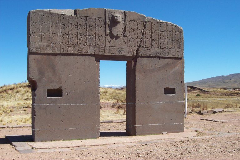
Pumapunku: A Tiwanaku Monumental Platform in Bolivia
Site at a Glance
- Rating
- 4.6
- Popularity
- Medium
- Country
- Bolivia
- Primary era
- Medieval
- Eras represented
- Medieval
- Civilizations
- Tiwanaku
- Site type
- Religious
- Remains
- Sanctuary
On this page13 sections
History
Pumapunku is a monumental platform mound at the Tiwanaku archaeological site in Bolivia, built by the Tiwanaku civilization during the Middle Horizon, an Andean period conventionally dated to approximately AD 500–1000. Its initial construction began between AD 536 and 600, while its later stonework formed part of a major pre-Inka complex. The name, meaning “Gate of the Puma” in Aymara and Quechua, refers to a place that was second in importance only to Akapana, another monumental mound traditionally associated with it as a twin.
Construction and Tiwanaku expansion
Radiocarbon dating of organic material from the deepest layer of the mound fill places the beginning of construction between AD 536 and 600. Because this layer lies beneath the andesite and sandstone masonry, the principal stonework was probably added later. Excavations identify three major building epochs, followed by repairs and remodeling.
Tiwanaku reached its greatest influence between approximately AD 700 and 1000. Its political and cultural reach extended across the Lake Titicaca basin and parts of present-day Bolivia and Chile. At the height of the civilization, Tiwanaku and its surrounding settlements may have supported between 10,000 and 20,000 inhabitants. Pumapunku was one of the major monumental complexes within this wider center.
The complex appears to have been left unfinished when Tiwanaku declined abruptly around AD 1000. Prolonged drought and resulting agricultural failure have been proposed as possible causes of that decline. Pumapunku was apparently abandoned before all of its monumental construction had been completed.
Ritual setting and later accounts
In Inka tradition, Tiwanaku was the place where the world was created. Pumapunku, together with Akapana, Kalasasaya, Putuni, and Kerikala, has been interpreted as a spiritual and ritual center that may have drawn pilgrims from distant regions. The complex was also understood as part of a landscape connected with Mount Illimani. Its channels may have contributed to a carefully arranged sensory experience involving the movement, sound, and sudden appearance of water. Psychoactive substances have been proposed in connection with Tiwanaku rituals, although their direct use at Pumapunku remains uncertain.
The Spanish conquistador Pedro de Cieza de León encountered the ruins in 1549 while searching for the Inka capital. Spanish visitors remarked on the large monoliths and precise masonry. The chronicler Bernabé Cobo later stated that a gateway and a “window” were still standing on one of the platforms, indicating that more of the architecture survived in the sixteenth century than remains today.
Destruction and archaeological interpretation
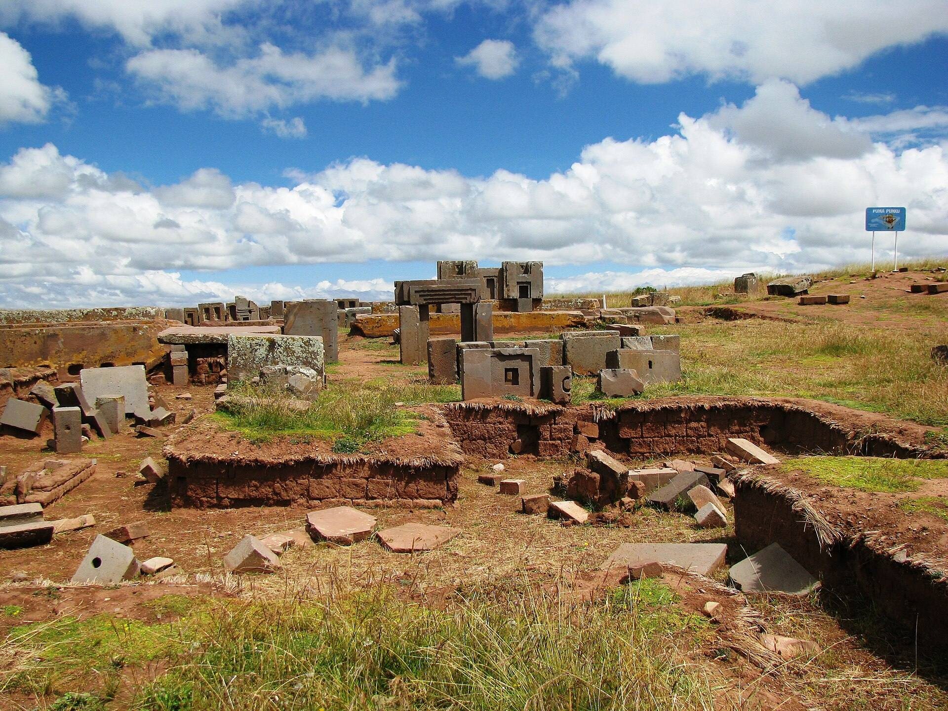
Natural weathering, treasure hunting, looting, and the quarrying of stones for construction and railway ballast caused extensive damage. Monumental structures were dismantled, and andesite blocks were scattered, buried, or transferred to the local museum. The surviving stones therefore no longer occupy their original positions.
Archaeological work, including excavation and radiocarbon research led by Alexei Vranich, has clarified the mound’s construction sequence. Geophysical surveys carried out around 2007 used ground-penetrating radar, magnetometry, induced electrical conductivity, and magnetic susceptibility to identify buried structures between Pumapunku and Kalasasaya. A drone survey in 2016 showed that only about two of the complex’s approximately seventeen hectares had been excavated, while two additional platforms remain underground.
The area between Pumapunku and Kalasasaya, about one kilometre away, contains buried evidence of an extensive settlement. Foundations, water conduits, pool-like installations, terraces, residential compounds, and broad gravel pavements extend beyond the exposed monument. Excavation trenches showed that the Pumapunku fill was placed directly on sterile Middle Pleistocene sediments, while the adjacent Tiwanaku area contained no earlier Middle Horizon cultural deposits before the Andean phase represented by the complex.
Claims that Pumapunku was built by people from Atlantis or by extraterrestrials derive from pseudoscientific interpretations of its high-altitude setting and precise masonry. Archaeological interpretations instead attribute the complex to communities of the Titicaca basin and identify local monumental precedents at Pukara and Chiripa. The Tiwanaku archaeological site, including Pumapunku, has been a UNESCO World Heritage Site since 2000.
Remains
Pumapunku is an artificial, strategically aligned, terraced platform mound with a T-shaped plan, a sunken court, and a monumental structure now reduced to ruins. The principal mound measures approximately 167.4 metres from north to south and 116.7 metres from east to west. Three levels of stone retaining walls enclosed a core made mainly of clay, while river sand and cobbles were used in parts of the edge fill.
Courts, platforms, and foundations
Terraced mound
The wider complex consisted of an unwalled western court, a central unwalled esplanade, the stone-faced mound, and a walled eastern court. Plazas and ramps formed part of this arrangement, including a western ramp leading toward the west entrance and a large eastern forecourt. Projections about 20 metres wide extend approximately 27.6 metres toward the north and south from the mound’s northeast and southeast corners.
The mound was built from sifted, layered soils. Andesite and red sandstone formed the superstructure and facing, while sandstone was used mainly for foundations and internal channels. The base combined alternating inner layers of sand with external composite layers whose overlapping joints graded the points of contact and created a stable foundation.
Stone Platform
At the eastern edge, the Plataforma Lítica, or Stone Platform, formed a stone terrace approximately 6.8 by 38.7 metres. Its paving included enormous red-sandstone slabs, among them the largest known blocks at Pumapunku and within the wider Tiwanaku site. One measured approximately 7.81 metres long, 5.17 metres wide, and 1.07 metres thick, with an estimated weight of about 131 tonnes. Another measured approximately 7.90 by 2.50 metres and averaged 1.86 metres in thickness, weighing an estimated 85.21 tonnes.
Petrographic and chemical analyses place the source of the large red-sandstone blocks near Lake Titicaca, roughly 10 kilometres away. Their transport required movement up a steep incline. Smaller andesite blocks used for facing and carving came from quarries on the Copacabana Peninsula, approximately 90 kilometres distant.
Hydraulic works
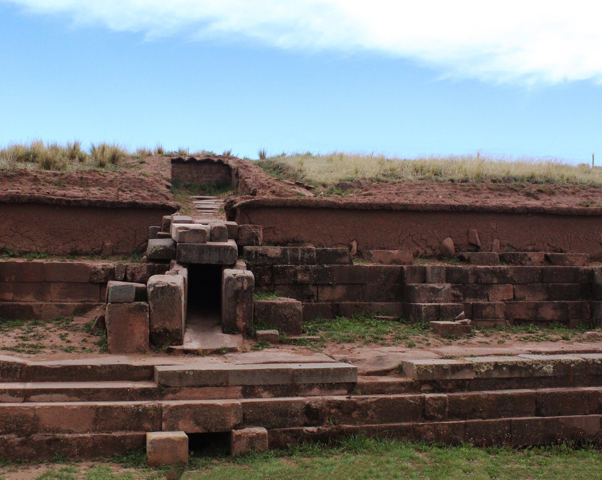
Stone-lined drainage and hydraulic systems ran through the complex. Sloping sandstone channels had cross-sections approximately 42 centimetres wide and 69.5 centimetres high. Water collected in the sunken court, passed through the upper and lower platforms, and left through outlets at the base. The channels could have served practical drainage needs as well as ritual purposes, since some researchers consider their capacity excessive for drainage alone.
The channel blocks fitted together like a puzzle and were secured with I-shaped cramps, metal fasteners inserted into sockets cut into adjoining stones. The cramps were made from a copper, arsenic, and nickel bronze alloy. In the southern channel, they were cast directly in place. Their calculated clamping force could reach about 44 kilonewtons, and some joints were assembled so tightly that a razor blade could not pass between the blocks.
Other cramps joined blocks in platforms and channel walls and floors. Several ornamental stones retain sockets for I-shaped cramps, suggesting that additional stones may once have been attached. Cramp sockets occur in L, T, double-T, U, Y, and Z forms. Lime-and-sand mortar containing ground malachite was associated with a turquoise-green plaster floor, while clay was associated with a red floor.
Gateways and carved stonework
Monolithic gateways
At least five full-size andesite gateways, together with several blind miniature gateways, were incorporated into or intended for the monumental complex. The foundation platform may have supported as many as eight full-size gateways. Fragments of five gateways share characteristics with the Gateway of the Sun.
Each full-size gateway was made as a single monumental unit, including its threshold. The fronts were smooth, while the rear surfaces were stepped or divided into sections. Bevelled jambs and lintels made the openings wider on one side, and rectangular recesses flanked the openings on the front faces. Miniature gateways reproduced the larger forms according to a consistent reduction formula. Some small model stones appear to have been made in multiple examples and fitted into larger architectural arrangements.
The Gateway of the Sun is sometimes proposed as a displaced structure from Pumapunku. Its rear patterns resemble designs on Pumapunku slabs and gateways, and its imagery has been interpreted as a stylized representation of the platform mound. This attribution remains an interpretation rather than an established fact. Pumapunku and other Tiwanaku areas also contained doubly curved lintels with complex surfaces, including lintels whose steep parabolic curves would be difficult to reproduce even with modern stoneworking methods.
Monoliths and sculptures
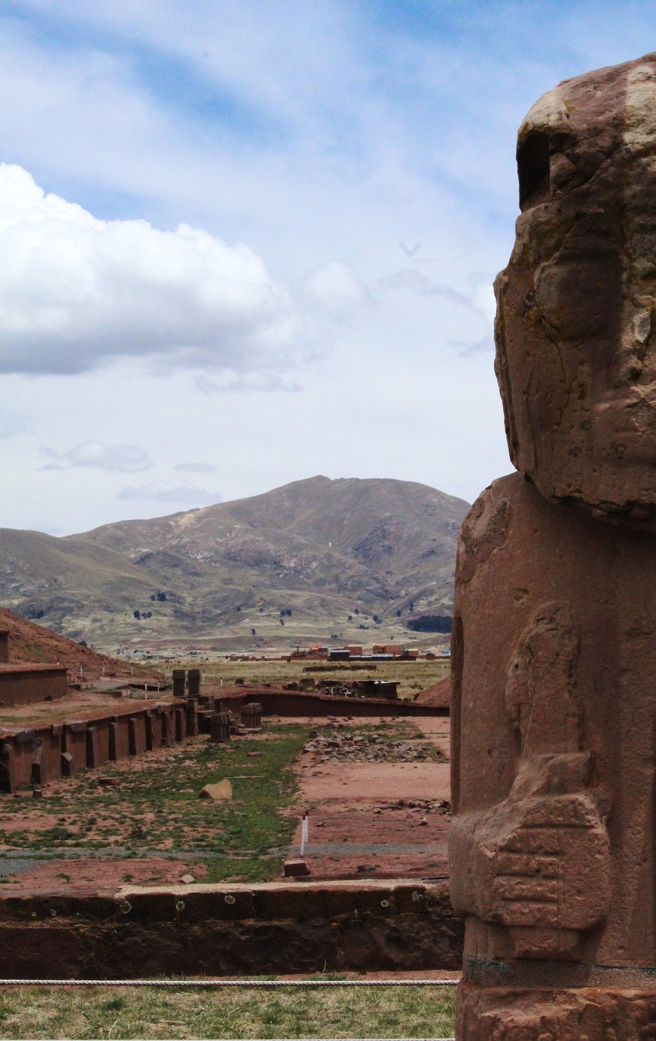
At least two monoliths were associated with the platform mound. The Pumapunku monolith, also called the Pumapunku stela, was found west of the complex and was first photographed in 1876. Chachapuma sculptures may once have stood on andesite pedestals beside an entrance. These crouching or kneeling figures combine predatory animal features with a human head in one hand and an axe in the other. Their proposed role in demanding human sacrifice from people entering monumental buildings remains uncertain.
Some stones preserve unfinished surfaces and traces of shaping methods. A white or whitish layer approximately 1 to 1.5 millimetres thick on certain blocks has been interpreted as a possible mortar layer. The tools used to create the exceptionally smooth surfaces, planar faces, and sharp interior angles have not been identified. The masonry nevertheless displays repeated geometric forms, exact interior and exterior right angles, and interlocking load-bearing joints. Many blocks were standardized enough to be interchanged while maintaining surface levels and joints, suggesting prefabrication, repetition, symmetry, and possibly mass production, although the blocks were not all the same size.
Entrance roofs were probably made with stone elements shaped to resemble totora reeds, a reed found around Lake Titicaca and traditionally used for construction. Similar stone elements were found near the western entrance.
Buried archaeological complex
The exposed ruins represent only a small part of the wider complex. Buried structures around Pumapunku include additional platforms, walls, terraces, water channels, pool-like features, residential areas, and extensive gravel surfaces. Andesite blocks are now scattered across the landscape, lie underground, or are held in the local museum, while the destruction of the monumental buildings has left the surviving architectural elements separated from their original arrangement.