Old Exe Bridge: Medieval Stone Crossing at Exeter
Site at a Glance
- Popularity
- High
- Country
- United Kingdom
- Primary era
- Medieval
- Eras represented
- Medieval
- Civilizations
- English
- Site type
- Infrastructure
- Remains
- Bridge
On this page15 sections
History
Roman and medieval crossings
Old Exe Bridge was a medieval stone road bridge across the River Exe in Exeter, England, United Kingdom. The crossing had been used since Roman times, when Exeter was established in the first century CE as Isca Dumnoniorum, an administrative centre in south-west England. The broad, shallow river at Exeter offered a dependable crossing for journeys west before the tidal estuary. A timber bridge may have served the Roman-era route. Until the twelfth century, however, people also had to contend with a hazardous ford, alongside a ferry for pedestrians.
In a sixteenth-century account, Exeter chamberlain and historian John Hooker described an earlier wooden bridge and winter floods that swept pedestrians from it. Local merchants Nicholas and Walter Gervase promoted a stone replacement. Work began around 1190 and was probably finished around 1210. A record of a bridge chaplain in 1196 indicates that construction was already in progress, and the completed bridge is mentioned by 1214. Walter travelled to seek donations. Hooker credited the Gervases with raising £10,000 in public contributions; they also acquired land whose income could support maintenance.
The new bridge replaced the ford and ferry as the main crossing, carrying a road from Exeter’s West Gate across the river and flood-prone marshes towards St Thomas. It probably had 17 or 18 arches, although estimates can be as low as 12, and repairs may have changed their number. Its length was at least 590 feet and may have reached 750 feet.
Chapels and churches
St Edmund’s Church formed part of the bridge and was dedicated to St Edmund the Martyr, an early medieval English king venerated as a Christian saint. A chaplain is mentioned in 1196, and the church appears in a list of Exeter churches by 1214. Walter Gervase’s parents were buried in the bridge chapel. Walter also established a separate chantry chapel across the bridge, dedicated to the Blessed Virgin Mary, the Christian title for Mary, mother of Jesus. A chantry was a chapel supported so that a priest could say prayers for the deceased. In 1257, an endowment of 50 shillings paid for prayers three times a week for Walter, his father, and his family. The chapel was in use by at least 1537 and was destroyed in 1546 during the dissolution of the monasteries, the Crown’s suppression of monastic institutions.
Hooker also reported that Walter and his wife were buried in another chapel attached to St Edmund’s, where a memorial to Walter stood. During the sixteenth-century Reformation, a period of religious change in western Christianity, this chapel was separated from the church and turned into a private dwelling. The memorial was removed and defaced.
St Thomas’s Church stood on dry ground at the western end of the bridge, at about the time of its construction. Dedicated to Thomas Becket, archbishop of Canterbury and canonized in 1173, it is first mentioned in 1191 and became Cowick’s parish church in 1261. A major flood in the early fifteenth century swept the church away. A replacement, set farther from the river on Cowick Street, was consecrated in 1412. After it was set alight during the English Civil War, the conflicts between supporters of the king and Parliament in the 1640s and early 1650s, the church underwent major rebuilding in the seventeenth and nineteenth centuries. It is Grade I listed.
Repairs and bridge administration
As land reclamation and silting narrowed the river on Exeter’s side by more than half, water pressed more forcefully against the bridge. Storms caused partial collapses in 1286 and 1384; the latter killed several people. The bridge was rebuilt after both events. By 1447 it was in poor condition, prompting Mayor John Shillingford to seek rebuilding funds. John Kemp, Archbishop of York, promised a contribution, but Shillingford’s death in 1458 interrupted the effort. A central arch collapsed in 1539 and was repaired with stone from St Nicholas’s Priory, though the entire bridge was not renewed.
Income from the Gervases’ land supported bridge repairs under the management of bridge wardens. Their estate included 15 shops on the bridge and more than 50 other properties in Exeter, among them mills and farmland. The wardens, and later the road trust, collected tolls from carts arriving from outside the city; Exeter citizens did not pay them. Parchment records kept by the wardens survive for 1343 to 1711, forming one of Britain’s fullest records for a bridge, surpassed only by those for London Bridge. A seal made for the wardens, probably soon after the bridge opened, depicts St Edmund’s Church or possibly the chantry chapel with houses beside it. The oldest known document bearing the seal was addressed to Exeter’s mayor in 1256 or 1264.
Responsibility for the bridge passed to the Exeter Turnpike Trust under the Exeter Roads Act in 1769. A turnpike trust managed roads and collected tolls for their upkeep. The trust was dissolved in 1884, after which Exeter City Council took responsibility for the bridge and its estate. By the late eighteenth century, traffic congestion had led to discussion of widening the medieval crossing, but the proposal was abandoned. The Exeter Roads Act of 1773 authorized repairs or rebuilding. In December 1775, a fire at the Fortune of War pub on the bridge also destroyed a neighbouring house. The pub offered inexpensive lodging to local vagrants; more than 30 people may have been inside, and at least nine bodies were recovered.
Replacement bridges and rediscovery
Construction of a replacement bridge began in 1770. Floodwater in 1775 swept away much of the partly built structure and damaged its foundations, delaying completion until 1778. Built by Joseph Dixon, the new masonry crossing had three arches and stood just upstream on a different, more direct alignment. By then, reclamation had narrowed the river to 150 feet. The medieval spans over the river were demolished, while arches on the Exeter bank were retained and later buried or incorporated into buildings.
In 1905, Dixon’s bridge was replaced by a three-hinged steel arch designed by Sir John Wolfe Barry, the British engineer associated with London’s Tower Bridge. After about 65 years, that bridge was demolished. Two reinforced-concrete bridges opened in 1969 and 1972. During the Second World War, a German bomb exploded nearby in the Exeter Blitz and exposed part of the medieval bridge. Construction work for the modern bridges revealed further arches. Associated road works removed part of Frog Street, an old brewery, and adjoining buildings. A timber-framed house was saved and moved elsewhere.
Exeter City Council commissioned local stonemasons to restore the uncovered medieval arches and made the surrounding area into a public park. The remains are a scheduled monument, a nationally important archaeological site protected by law, and a Grade II listed building, a category for buildings of special interest. They are identified as England’s oldest surviving bridge of their size and Britain’s oldest bridge with a chapel still on it.
Remains
Bridge spans and construction
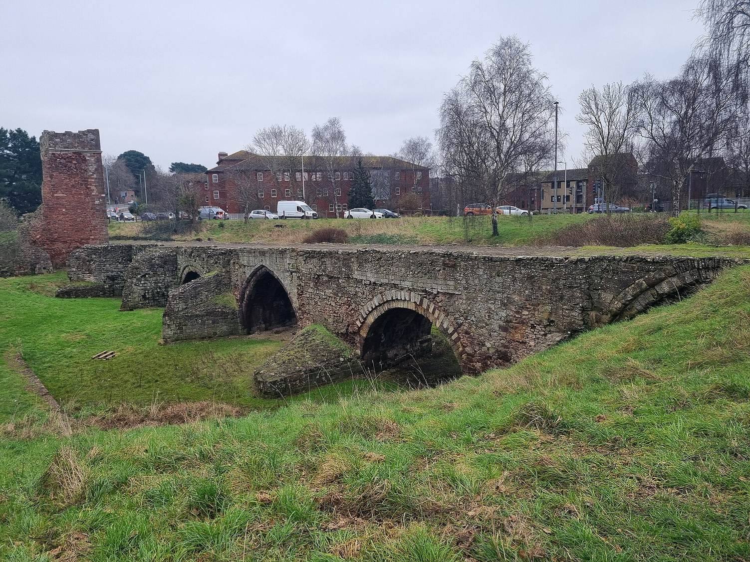
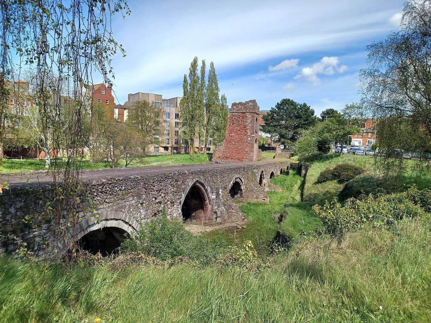
The surviving masonry follows the medieval route diagonally from near Exeter’s West Gate towards St Thomas, then beyond the city. About half of the original bridge remains unburied: eight and a half arches extending roughly 285 feet. A further three and a half arches, spanning about 82 feet, lie buried, with other parts beneath modern buildings. Around 82 feet of the bridge is under Edmund Street and the modern riverbank, and bases of demolished arches remain in the riverbed. The visible arches span between 12 and 19 feet and rise as much as 20 feet. The bridge averaged about 16 feet in width; at its highest point, the roadway measured about 12 feet between the parapets, allowing two carts to pass side by side. Medieval and later paving survive.
The bridge combines semicircular arches associated with Norman architecture and pointed arches associated with Gothic design. Both forms belong to the original construction. The arches rest on ribbed stone vaults, in which projecting ribs support the vaulted ceiling. Pointed arches have five ribs, each about 18 inches wide and set roughly 36 to 42 inches apart. The semicircular arches have three ribs, about 36 to 42 inches wide and spaced around 30 to 36 inches apart.
The piers are rounded on their downstream faces and have upstream cutwaters, projections that deflect water. Triangular recesses above these projections gave pedestrians places to shelter as carts passed. The arch faces are made of local trap stone, a dark-coloured igneous rock. Behind them, timber stakes driven into the ground and riverbed form box-like supports for gravel and rubble. Timber foundation piles were reinforced with iron and lead; near the banks, where the water was shallower, builders placed gravel and rubble directly on the riverbed. Sandstone and limestone from East Devon were also used, while later repairs incorporated Heavitree breccia, a local rock made of fragments cemented together.
Tree-ring analysis, which dates timber through its growth rings, places the felling of the oldest foundation stakes between 1190 and 1210. Some piles recovered after part of the bridge was demolished in the eighteenth century had spent about 500 years underwater and were found blackened and very solid.
Churches and chapels
St Edmund’s Church
Two surviving arches form the crypt of St Edmund’s Church, a chamber beneath the church. The rectangular building measured about 54 feet by 16 feet 6 inches. Its south wall rested on the north side of the bridge, while the side walls stood on cutwaters. Piers rising from the riverbed supported the north wall. The church had an entrance from the bridge and may also have had one below it. In the seventeenth century, builders blocked the arch beneath the aisle.
Silting and reclaimed land allowed the church to grow. By the end of the fourteenth century its west wall stood on dry ground, and builders extended the north side with an aisle, widening the church by about 7 feet. Work on a bell tower began in 1449, followed by further additions in the sixteenth century. Lightning damaged the church in 1800, and it was largely rebuilt in 1834. A fire in 1882 caused severe damage; repairs the next year retained much older stonework. Another fire in 1969 left the building in ruins. In 1975, later additions were largely removed and medieval masonry preserved. The tower survives at its original height.
Chantry chapel
Stone fragments from the foundations of Walter Gervase’s separate chantry chapel survive on the other side of the bridge from St Edmund’s.
Memorial chapel
Foundation remains survive from the other chapel that Hooker described as attached to St Edmund’s. By the nineteenth century, the structure had been reduced to these foundations.
Buildings on and beside the bridge
Bridge-top shops and houses
Timber-framed shops and houses occupied the bridge from at least the early fourteenth century. The earliest recorded example, from 1319, consisted of two shops with houses above. At the height of this development, buildings covered all but the six arches in the middle of the river. Their front walls rested on the parapets, while timber posts planted in the riverbed supported the rest of the structures. Some of the support timbers came from trees felled between 1190 and 1200. The buildings were demolished in 1881.
Frog Street buildings
By the late thirteenth century, silting on Exeter’s side had created land for two buildings backing onto the river and facing what became Frog Street. One may have been a tannery. Their foundations survive. A wall running from the west side of St Edmund’s protected further riverside buildings, and houses and shops along it became known as Frog Street.
Relocated timber-framed house
The timber-framed house saved during twentieth-century road works resembles the architectural style of the houses formerly built on the bridge.