Old Dongola: Capital of the Medieval Nubian Kingdom of Makuria
Site at a Glance
- Popularity
- High
- Country
- Sudan
- Primary era
- Medieval
- Eras represented
- Classical, Medieval, Early Modern
- Civilizations
- Christian Nubian Kingdoms
- Site type
- City
On this page23 sections
History
From fortress to Christian capital
Old Dongola is the remains of a medieval Nubian city in Sudan, founded as a fortress in the fifth century. It became the capital of Makuria, a medieval Nubian kingdom, in the mid-sixth century, as Christianity was introduced by missionaries from the Byzantine Empire, the eastern continuation of the Roman Empire. Dongola also served as a departure point for caravans traveling west to Darfur and Kordofan, regions of western Sudan.
In the seventh century, Makuria united with Nobadia, a neighboring kingdom to the north, creating a larger Christian Nubian kingdom with Dongola as its capital. The city retained its Christian political importance into the fifteenth century. It grew beyond its original fortress, and its period of greatest prosperity came between the ninth and eleventh centuries. Building continued into the fourteenth century.
Conflict and political change
In the mid-seventh century, the city’s two main churches were destroyed and soon rebuilt. Stone from the Old Church was also reused to repair the city walls. These events have been interpreted as evidence of the First and Second Battles of Dongola, fought in 642 and 652.
A travelogue compiled by a Spanish monk shortly after 1348 describes Genoese merchants living in Dongola. Their settlement may have followed a commercial treaty between Genoa and Egypt in 1290. A surviving inscription dated 1317 is commonly understood to refer to an Egyptian sultan’s military expedition to place his chosen ruler, Abdullah, on the throne. Abdullah may have been a Muslim Nubian. In the same year, the building identified as the kings’ Throne Hall was converted into a mosque. This change is treated as a symbolic marker of Nubia’s transition from Christian to Islamic rule.
The royal court left Dongola in 1364. The city continued as the center of a smaller kingdom and, under the Funj, a Muslim ruling dynasty based at Sennar, became the capital of the northern provinces. Its hereditary local ruler was known as a Mekk, or local hereditary ruler, and remained subordinate to the Funj sultan while exercising authority in the area. He could also use the Arabic title Malik, meaning king. Over the centuries after the last Christian rulers fell, the surrounding region gradually became more Arabic-speaking and Muslim.
Funj rule, decline, and abandonment
The area was incorporated into the Funj kingdom in the sixteenth century. Trade with the Far East and Europe continued, although it declined after the rise of the Shaigiya, a tribal confederacy that affected regional commerce. In 1699, French traveler Charles-Jacques Poncet described a town on a sandy hill, with poorly built houses and sand-filled streets. He also noted a spacious central castle that was only lightly fortified.
The town was abandoned in the eighteenth century. In 1812, Mamluks, a military elite that held power in parts of the Islamic world, including Egypt, took control of Old Dongola after fleeing purges in Egypt. They founded New Dongola downstream, and the new settlement drew commercial and economic activity away from the old town. During the nineteenth century, the region’s population center shifted about 80 kilometers downstream to the opposite bank of the Nile, where modern Dongola developed.
Archaeological research
Polish archaeological work began at Old Dongola in 1964, after Kazimierz Michałowski’s team had worked at Faras, another medieval Nubian settlement. The first investigations were conducted through the Mediterranean Archaeology Station in Cairo, now the Polish Centre of Mediterranean Archaeology at the University of Warsaw, with support from Sudan’s National Corporation for Antiquities and Museums. Architect Antoni Ostrasz directed the first expedition; Stefan Jakobielski and Włodzimierz Godlewski later led research over several decades.
Surveys in 1986 and 1988 recorded about 40 sites around the city. Excavation at Kom H began in 1990, and work on the monastery there followed in 1991. From 2017, the UMMA project investigated later layers of the site, with archaeologist Artur Obłuski leading the team from 2018. The mosque in the former Throne Hall remained in use until 1969, when the building was converted into a historic monument.
Remains
The archaeological site covers about 200 hectares, while the ruins of the urban settlement extend across roughly 35 hectares. The city occupied a rocky rise on the Nile’s east bank, between the Third and Fourth Cataracts, stretches of rapids and rocky shallows, and opposite Wadi Howar, an ancient valley in Sudan. Its remains include a fortified southern center, residential and industrial districts to the north, churches, monastic buildings, and burial grounds.
Urban layout and suburbs
Walled center and northern districts
The citadel and principal urban buildings occupy the southern part of the site. The citadel held the royal residence, palaces, and public buildings, while fortified walls enclosed the city center. The settlement extended north beyond the walls into a suburban area containing homes, churches, and an industrial quarter.
Residential and industrial quarters
A residential district dating from the seventh to thirteenth centuries developed north of the walled town, alongside two monastic complexes and an industrial area. The latter contains the largest known concentration of ceramic workshops in this part of Africa. Suburban homes include well-equipped houses with bathrooms and wall paintings.
Churches
Early church sites
Among the early churches were Building X and the Church with the Stone Pavement, both about 100 meters from the walled center. Building X was soon replaced by the Old Church. The Church with the Stone Pavement was later succeeded by the Cruciform Church, built over earlier religious buildings dating to the sixth and seventh centuries.
Church of the Granite Columns
At the end of the seventh century, the Church of the Granite Columns was built over the Old Church. Its interior had 16 granite columns with richly decorated granite capitals. The building may have served as Dongola’s cathedral and was regarded as a model for the cathedral at Faras.
Cruciform and later churches
The Cruciform Church, built in the ninth century at the foot of the fortified rise on its northern side, had a cross-shaped plan. More than a dozen churches have been identified at Dongola. Early examples follow Byzantine models, while a local design used a central cross-shaped plan either alone or together with a rectangular church layout. Later churches could have a central dome. Other examples of this tradition include the ninth-century Pillar Church by the Fortress Walls, a tenth-century church at Kom D, and the Southwestern and Northern churches, both dated to the thirteenth century.
Church with Mosaics
The Church with Mosaics is among the oldest churches at the site. Some of its features reflect late Meroitic building traditions, associated with the culture of the ancient Kushite kingdom centered at Meroë.
Excavated church and painted apse
Excavation in 2021 revealed a church apse, a rounded recess at a church’s end, about nine meters deep, together with an attached wall and a nearby tomb dome. The church’s eastern portion survives to a height comparable to three storeys of a typical residential building. Two rows of colossal painted figures decorated the apse. The church may have been a cathedral and may have been the largest known medieval church in Nubia.
Paintings probably dating to the thirteenth century include a portrait of the Virgin Mary and a scene in which the archangel Michael presents a Nubian king to Jesus. Jesus sits on a cloud and extends a hand for the king to kiss. The scene is an unusual depiction of interaction between human and divine figures in Byzantine Christian art.
Monastery at Kom H
Church and successive building phases
The Great Monastery of St Anthony, also known as the Monastery of the Holy Trinity, lies at Kom H, an excavation area about 1.5 kilometers northeast of the citadel. It was founded in the seventh century by Coptic monks and enlarged in the eleventh, twelfth, and thirteenth centuries. An inscription connects the monastery with St Anthony the Great, an Egyptian Christian monk regarded as an early founder of monasticism; texts from the archbishop’s crypt also name the Holy Trinity, the Christian belief in one God in three persons.
The earliest church was a three-aisled basilica, a church with a central nave and side aisles, measuring 29 by 13 meters. Its eastern end had three sections, while three rooms at the west occupied the area of the narthex, the church’s entrance hall. The church had entrances on its north and south sides, fired-brick walls, a floor of ceramic slabs, and gray granite columns supporting the roof. This first phase survives to a height of about 1.5 meters.
During the reign of King Merkurios, around the turn of the seventh and eighth centuries, builders added a dome above the central part of the main nave. It rested on piers joined by arches made from sandstone blocks. In the twelfth century, the church interior was divided into smaller rooms.
Monastic buildings and annexes
Excavations at Kom H have exposed 50 rooms, as well as part of a monastic building, a service area, a seventh-century church, and a burial ground. The Northwestern and Southwestern Annexes contain 40 rooms connected by passages with arches. Two other buildings date to the tenth century. One was used as a cellar for the monastery building; the other may have served for contact with people outside the complex.
In the eleventh century, Bishop Georgios expanded an annex and decorated its walls with paintings. Toward the end of that century, a crypt, a chamber beneath a church, was incorporated into the complex, with a chapel above it that had a decorated portal. A room with two towers shaped like apses was also added. In the twelfth century, another complex commemorating Georgios was established in the annex.
Burials, inscriptions, and painted decoration
Georgios, archbishop of Dongola and a senior church leader, was buried in a church crypt. His funerary stele, an upright inscribed stone, associates St Anthony the Great with the monastery. The archbishop’s crypt also contained many texts in Greek, Coptic, the historic language of Egyptian Christianity, and Old Nubian, a medieval language used in Nubia. The monastery has yielded liturgical inscriptions, funerary stelae, and graffiti in these languages. The walls of Georgios’s commemorative complex carry texts relating to Mary and other religious writings in Greek and Coptic.
About 100 painted compositions dating from the eleventh to thirteenth centuries have been recorded on the monastery buildings; the 50 excavated rooms contained 125 paintings. Their subjects include Christ, Mary, the Trinity, archangels, angels, apostles, saints, scenes from the Old and New Testaments, and religious and secular leaders, including local bishops and kings. The paintings combine local traditions with Arab artistic influence and African folklore. They were made using al secco, a method of painting on dry plaster, at about 1.5 meters above floor level.
Several paintings represent the Trinity as three identical images of Christ. In some, the figures appear within a medallion surrounded by the Four Apocalyptic Beings, symbolic creatures associated with visions in the Book of Revelation, or emerge from scale-like clouds. Another version shows Christ with three heads. Images of Mary include the Hodegetria type, in which she presents the Christ Child as the way to salvation, and scenes of her nursing him. One image combines nursing with spinning.
Three paintings show the Three Youths in the Fiery Furnace. Two use imagery also found at Faras, while a third includes two people carrying wood to the furnace. Other subjects include the Nativity, repeated images of Michael as a protector, and Christ crowning a Nubian king. Two paintings show the preparation of bread and wine for the Christian Eucharist. Less usual scenes depict two men dancing and what may be a commercial transaction. In donor images, a much larger figure holds a donor from behind in a protective gesture; these scenes have been interpreted as evidence that the paintings served a votive purpose.
Royal building and burial grounds
Throne Hall
A large building on a rocky spur east of the fortress has been identified as the Throne Hall of the Makurian kings. It measures 28 by 18 by 12 meters and had two storeys. Its walls stood 6.5 meters high on the ground floor and 3.5 meters on the upper floor. The ceremonial hall occupied the first floor. The building survives from its foundations to its roof.
Muslim cemetery
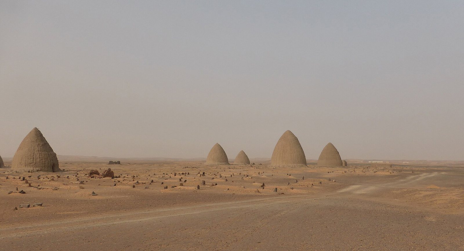
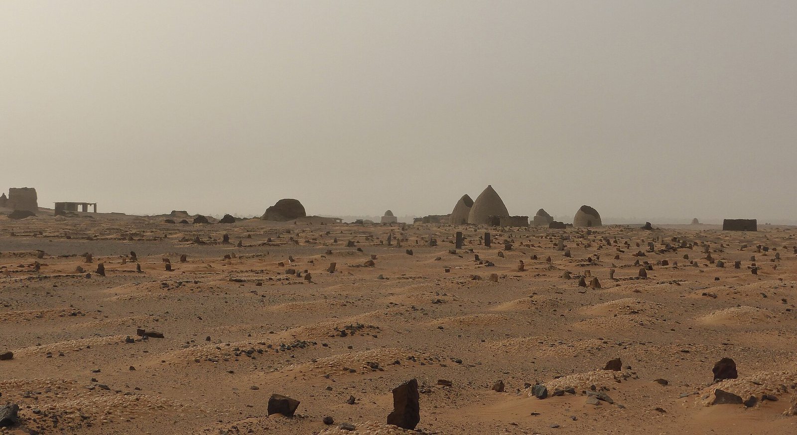
A large Muslim cemetery east of the former hall contains numerous qubbas, or domed tombs, dating to the seventeenth century. Older Christian burial grounds lie farther away.
Other archaeological finds
Stone blocks bearing ancient Egyptian hieroglyphs and figural decoration have been identified as parts of a pharaonic temple. Other finds from Old Dongola include pottery, fragments of architectural decoration, epitaphs with Coptic and Greek inscriptions, and small everyday objects. Most of these movable finds are held in a museum in Khartoum.