Megalithic Temples of Malta: Prehistoric Religious Complexes


Site at a Glance
- Rating
- 4.4
- Popularity
- Medium
- Country
- Malta
- Primary era
- Bronze Age
- External website
- Open
- Eras represented
- Stone Age, Bronze Age
- Civilizations
- Maltese Temple Culture
- Site type
- Religious
- Remains
- Temple
On this page20 sections
History
The Megalithic Temples of Malta are a group of prehistoric temple complexes in Malta, built by local Neolithic communities between about 4100 and 2500 BC. Their principal monumental complexes date chiefly from about 3600 to 2500 BC and represent successive developments in Maltese prehistoric architecture. The temple-building culture disappeared around 2500 BC after a period of burning and social disruption.
Neolithic Settlement and Early Phases
Human activity on Malta began in the Early Neolithic. The earliest occupation connected with the temple sequence belongs to the Għar Dalam phase, around 5000 BC, when farming communities reached the islands from Sicily by boat or raft. They brought domesticated goats and sheep, along with barley, lentils, and wheat. Obsidian from the Aeolian Islands and Pantelleria shows that these communities maintained contact and exchanged materials with Sicily and nearby islands.
The first phase of the temple sequence, Żebbuġ, lasted about 4100 to 3800 BC. It is associated with rock-cut family graves, which may reflect forms of ancestor veneration. The less clearly understood Mġarr phase followed around 3800 to 3600 BC. These early developments established traditions that later communities transformed into increasingly large and complex ceremonial buildings.
The Temple-Building Tradition
The Ġgantija phase, approximately 3600 to 3000 BC, produced the earliest datable temples and introduced the lobed, trefoil, and five-apsed plans that became characteristic of Maltese temple architecture. The Saflieni phase, about 3300 to 3000 BC, was a transitional period associated with Ġgantija-style pottery and new biconical bowls. The Tarxien phase, approximately 3150 to 2500 BC, brought the most elaborate development of the tradition, including advanced stone carving, sculpture, pottery, and decorative work.
Archaeologists regard the temples as the product of local cultural innovation rather than an imported Aegean tradition. They were once described as the oldest free-standing structures on Earth, but the discovery of the substantially older, largely buried complex at Göbekli Tepe in southeastern Turkey invalidated that claim. The chronology of the Maltese temples is based on calibrated radiocarbon dating and is divided into five phases, although dating remains difficult where later Bronze Age activity covered Neolithic remains or where new buildings modified earlier traditions.
Sir Temi Żammit, a leading Maltese archaeologist, proposed an early chronology for the Neolithic temples and the Tarxien culture. Some scholars initially reduced his dates by roughly half a millennium, but radiocarbon testing later supported his broadly early interpretation.
Religious and Social Functions
The temples probably served as religious centers. They may also have supported political and economic activities, such as distributing food, organizing craft production, and regulating agricultural or trading activity. Female figurines, funerary contexts, and the relationship between apsidal temple plans and earlier kidney-shaped family graves have encouraged interpretations involving fertility rites and ancestor veneration, although these interpretations remain debated.
In some temples, movement and visibility appear to have become increasingly restricted through the use of screens and possible openings associated with oracles. These arrangements may reflect privileged access for a religious and political elite. Theories that temple communities were divided into territories belonging to clans, or that rivalry increased the dominance of the Ġgantija and Tarxien centers, remain interpretive reconstructions rather than established facts.
The sun and stars also formed part of the religious or symbolic world associated with the temples. The Tal-Qadi star map and astronomical alignments at Mnajdra and Ħaġar Qim point to an interest in the sky. The oldest temples were generally oriented toward Sicily, and a fragment of a stele showing part of the sky, including the moon and radial lines, may have served as an orientation device.
Decline and Archaeological Rediscovery
The end of the Tarxien phase coincided with burning around 2500 BC. Food crisis, overpopulation, chronic undernourishment, epidemic disease, and conflict with a powerful religious and political elite have all been proposed as possible causes, but the precise explanation remains uncertain. The collapse was not caused by an external invasion. Some groups may have left Malta for Sicily and North Africa.
Interest in the temples grew during the eighteenth and nineteenth centuries. Ġgantija was first excavated in 1827, when debris was cleared without adequate archaeological recording, resulting in the loss of soil and remains. An earlier plan by Jean-Pierre Houël and paintings by Charles Frederick de Brocktorff, made shortly after the clearance, preserve important records of the site during its early investigation. Sir Temi Żammit excavated Ta’ Ħaġrat between 1925 and 1927 and investigated the Tarxien complex in the early twentieth century. Excavations at Skorba were especially important for understanding early settlement and the development of temple architecture.
The Ġgantija temples were inscribed on the UNESCO World Heritage List in 1980. In 1992 the listing was extended to Ħaġar Qim, Mnajdra, Ta’ Ħaġrat, Skorba, and Tarxien, and the World Heritage property was extended again in 2015. Heritage Malta manages the sites, while ownership of surrounding land varies between locations.
Remains
The temples generally consist of curved, horseshoe- or kidney-shaped buildings arranged around apses, or curved chambers opening from a central space. Their approaches lead through oval forecourts that were levelled or terraced on sloping ground. Façades usually face south or southeast and form one side of the forecourt. Plans contain three, four, five, or six apses, with lengths ranging from about 6.5 metres at Mnajdra’s east temple to 23 metres at Tarxien’s six-apsed central temple.
Construction and Decoration
Walls were built chiefly from orthostats, large stone slabs set upright in courses. Entrances commonly used trilithons, formed by two upright stones supporting a large horizontal lintel. Additional trilithons created paved passages leading to open spaces and pairs of D-shaped chambers. Loose stone and earth, sometimes containing pottery debris, filled the space between internal and external walls. This construction produced massive load-bearing walls capable of supporting heavy roofs.
Floors were made from torba, a lime-based plaster or flooring material produced from crushed local limestone, or from large stone slabs. Harder coralline limestone was generally used for external walls, while softer globigerina limestone served for internal elements and decoration. Reliefs include continuous spirals, trees, plants, and animals. No temple retains a complete roof. Evidence from Ġgantija and Mnajdra suggests some form of corbelled construction, possibly combined with timber roofing. Tarxien may have had an upper floor or roof terrace used as a ceremonial platform, although this remains uncertain.
The movement of the megaliths remains unresolved. Large stone balls may indicate the use of stone rollers, while some blocks appear to have been dragged for several kilometres. Wooden rollers have been proposed, but Malta may not have possessed enough timber for their extensive use. The so-called cart ruts may represent sled systems, although their date and origin remain uncertain. Many do not approach temple sites, while a processional route to a hypogeum has been identified.
Underground and Ritual Remains
Ħal Saflieni Hypogeum
The Ħal Saflieni Hypogeum is an underground complex covering about 500 square metres. It was discovered accidentally in 1902 during the construction of a cistern, and delayed disclosure of the find led to extensive looting before excavation. The complex reaches a depth of 10.6 metres and contains 32 interconnected chambers. Estimates of 6,000 to 7,000 burials remain disputed because they were extrapolated from one excavated chamber, while other skeletal remains had been scattered on fields as fertilizer.
Red-ochre paintings survive on ceilings and walls, including a decorated niche. They provide evidence that above-ground temples may also have carried rich decoration. The function of individual rooms remains difficult to determine. The suggestion that one acoustically resonant space served as an oracle chamber is a modern interpretation rather than an established fact.
Figurines and Small Objects
Figurines from temples and hypogea include corpulent female figures, some wearing skirts, and sexually ambiguous figures. Their interpretation as fertility images, idealized bodies, symbols of clan mothers, or references to death and sleep remains uncertain. The so-called Sleeping Lady from the Ħal Saflieni Hypogeum is a reclining clay figure with broad hips and a fringed skirt, coloured with red ochre. It is preserved in the Archaeological Museum of Valletta.
Ġgantija produced a figurine of a seated couple wearing similar skirts, now held in the Archaeological Museum of Victoria. Seated figures wear long pleated garments, while their separately made heads were fitted to the bodies. Some recovered heads have been described as having thick lips and tightly curled hair. Small round altars bear reliefs of trees or plants, possibly including a tree-of-life motif. Other objects include a fire altar, a stone vase, spiral-carved stones, animal and plant reliefs, and a copy of the large Tarxien statue. The original statue, whose upper half was not recovered, is in the Archaeological Museum of Valletta and was probably about two metres long.
Ġgantija and the Northern Temples
Ġgantija
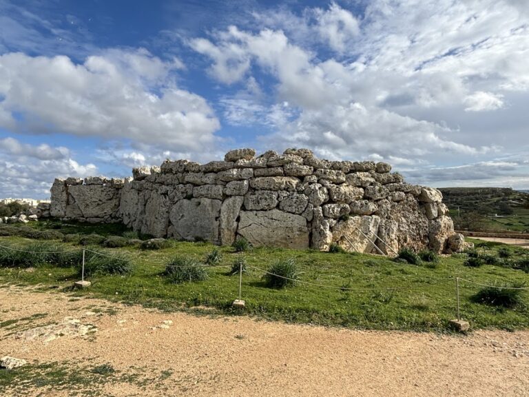
Ġgantija stands at the end of the Xagħra plateau, facing southeast. A boundary wall encloses two temples, each with its own entrance. The southern temple has five apses and is older and better preserved than the northern temple. Its walls contain blocks weighing up to about 50 tonnes and survive in places to approximately seven metres high. The walls were originally coated with white torba plaster.
Megaliths were transported from distances of roughly two or three kilometres. Offerings were found beneath a threshold stone weighing about 50 tonnes, and figurines were discovered in situ on flat altar tables. The complex was eventually destroyed by a severe fire around 2500 BC. There is no evidence of foreign attackers.
Ta’ Ħaġrat
Ta’ Ħaġrat at Mġarr consists of two adjacent, relatively small and irregularly planned trefoil temples. The site lies on the eastern edge of the village, about one kilometre from Skorba. It also contains remains of a settlement predating the temples, including abundant pottery from the Mġarr phase. The temple blocks lack stone decoration.
Skorba
Skorba preserves the characteristic three-apsed plan of the Ġgantija phase. Much of the first two apses and the entire façade were destroyed to ground level, while the entrance paving, a perforated portico, torba floors, a large upright slab of coralline limestone, and the better-preserved north wall survive. The original entrance opened onto a court. During the Tarxien phase the entrance was closed, and altars were placed in the corners of the enclosed space.
A second four-apsed monument with a central niche was added east of the first temple during the Tarxien phase. Skorba’s oldest structure is an eleven-metre-long straight wall west of the first temple entrance. Deposits against it contained charcoal, carbonized grain, and accidentally fired fragments of daub from a settlement that occupied the area for roughly twelve centuries before the temples were built. The charcoal was radiocarbon dated to about 4850 BC.
Southern Temple Groups
Ħaġar Qim
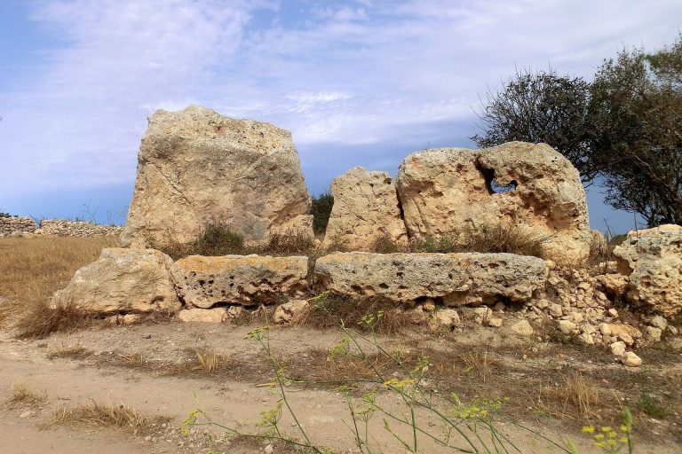
Ħaġar Qim stands on a ridge about two kilometres from Qrendi and Siġġiewi. Its builders used the soft globigerina limestone capping the ridge. The southern external wall has consequently suffered severe weathering and surface flaking from exposure to sea winds. The façade includes a trilithon entrance, a bench, and orthostats, while the temple has a broad forecourt with a retaining wall.
A passage runs through the centre, and a separate entrance leads to four independent enclosures that replace the northwestern apse. An oval opening in one chamber admits sunlight at the summer solstice, forming part of the astronomical features associated with the complex.
Mnajdra
Mnajdra lies in a hollow about 500 metres from Ħaġar Qim, toward the sea. Three adjacent temples overlook an almost circular forecourt, while a terrace separates the complex from a steep slope descending toward the sea. The oldest temple is a small, irregular trefoil building of the Ġgantija phase with pitted decoration. Its unusual triple entrance was reproduced on a larger scale in the second temple.
The middle temple was inserted between the others during the Tarxien phase after 3100 BC. It contains four apses and a niche. The third temple was built early in the Tarxien phase at a lower level and has a markedly concave façade, a bench, orthostats, and a trilithon entrance.
The southern temple is aligned with the rising sun. At the summer solstice, sunlight reaches the edge of a decorated megalith between the first apses. At the winter solstice it illuminates a megalith in the opposite apse, while at the equinoxes sunlight passes through the principal doorway to the innermost central niche.
Tarxien and Later-Associated Remains
Tarxien
The Tarxien complex lies about 400 metres east of the Ħal Saflieni Hypogeum and is surrounded on all sides by modern urban development. Its southern temple has a rounded façade and a large cistern beneath the forecourt. The earliest northeastern temple was built about 3600 to 3200 BC and had two parallel sets of semicircular apses separated by a central passage.
The southern and eastern temples date to approximately 3150 to 2500 BC. The southern temple has three parallel semicircular apses linked by a large passage, while the eastern temple has two parallel sets of apses and a passage with the same general orientation as the southern temple.
The first temple is solidly built from large stones, some roughly dressed, with accurately laid walls. The second has more carefully finished walls and standing slabs decorated with flat raised spirals. One chamber contains low-relief figures of two bulls and a sow. The third has a less carefully built structural frame, but most of its standing stones are richly carved. The lower part of a large statue was found in the first right-hand apse of the southern temple. The original is preserved in the Archaeological Museum of Valletta, while a copy stands at the site.
Other Temple Sites
Several related sites preserve remains in different conditions. Debdieba was excavated and later reburied, while Kordin I and II were destroyed. Buġibba Temple survives in better condition but is now within hotel grounds, and Ta’ Marżiena has never been excavated. The remains range from scattered megaliths to comparatively substantial temple structures.
Other megalithic and related sites include Borġ l-Imramma, Borġ in-Nadur, the Kordin complexes, Ħal-Ġinwi, Qortin l-Imdawwar, Santa Verna, Ta’ Raddiena, Tal-Qadi, Tas-Silġ, Xemxija, and Xrobb l-Għaġin. Tas-Silġ contains limited megalithic remains alongside more substantial Bronze Age and later remains because the location continued in use until at least the ninth century AD. Cart ruts at Misraħ Għar il-Kbir may belong to the temple period, but their date is uncertain. A submerged site off the Maltese coast, known as Ġebel ġol-Baħar, has been proposed as a megalithic temple but has not been proven to be one.