Krasnyi Dvir Hill Fort: A Princely Residence in Kyiv
Site at a Glance
- Popularity
- Low
- Country
- Ukraine
- Primary era
- Medieval
- Eras represented
- Medieval, Early Modern, Modern
- Civilizations
- Kievan Rus
- Site type
- Domestic
- Remains
- Palace
On this page8 sections
History
Krasnyi Dvir Hill Fort was a fortified locality and suburban residence on Cape Chaika in Kyiv, Ukraine. Archaeologist Ivan Movchan proposed that Vsevolod Yaroslavich, a prince of Kyivan Rus, the medieval polity centered on Kyiv, established the residence on the cape’s upper plateau in the 11th century. A chronicle also mentions the princely palace, and other princes of Kyiv later used the site.
The eleventh-century residence
In 1096, Bonyak, a Cuman ruler from a Turkic people of the Eurasian steppe, attacked Kyiv and burned Krasnyi Dvir. The palace was later restored.
Twelfth-century princely use
Yuri Dolgoruky, a prince of the northeastern Rus lands who also held the Kyiv throne, lived at Krasnyi Dvir during his reigns in 1149–1151 and 1155–1157. After he was poisoned, an uprising in Kyiv in May 1157 ended the authority of the Suzdal forces he had installed and destroyed princely property. Krasnyi Dvir was plundered.
Excavation and protection
Excavations took place at the site in 1971. In 1979, its hillfort zone became part of an archaeological reserve that also covered Vydubychi Monastery and the Zvirynets caves. The site received protected status in 1987, and its cultural layer was included among Ukraine’s nationally important archaeological monuments through government resolutions in 2001 and 2009.
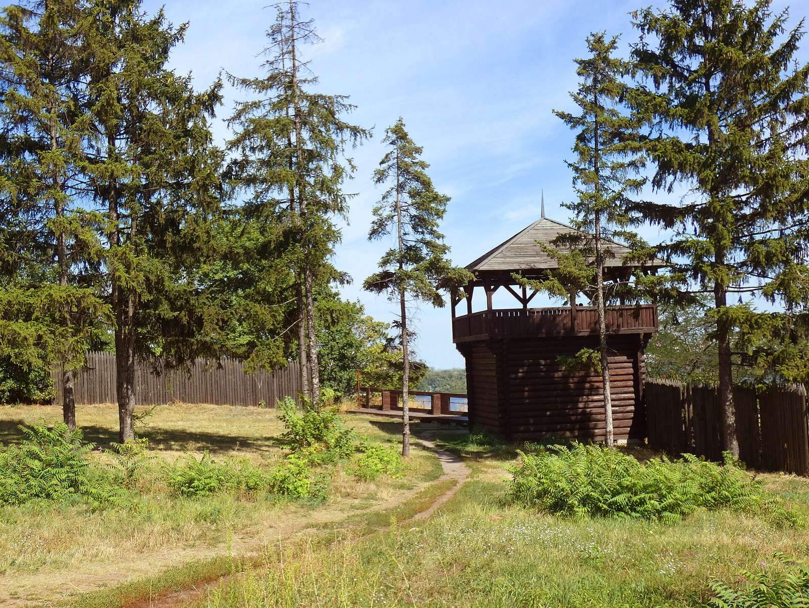
In 2010, local activists and the botanical garden’s management sought to create a viewing area inspired by the fortifications of Kyivan Rus. The new complex opened on 4 November that year.
Remains
Plateau and defenses
Cape Chaika rises about 70 metres above the Dnipro River between the Vydubychi and Navodnytska valleys. Its plateau measures about 150 by 70 metres and connects to the main cape by a narrow isthmus. Vydubychi Monastery lay to the south and Navodnytska Harbour to the east. A defensive ditch crossed the isthmus, while an earthen rampart followed the plateau’s northern and western edges. The rampart was levelled during landscaping for the botanical garden.
Archaeological evidence
Excavations on the cape’s lower platform uncovered shallow finds associated with the Trypillian culture, a prehistoric archaeological culture of eastern Europe, including pottery fragments, a flint scraper and clay weights. A burial dated to the second century BCE contained embossed metal plaques and is attributed to an early Iron Age culture. Other finds span the 11th–13th centuries to the 17th century, including pottery fragments from the 13th–14th centuries, clay vessels and metal objects. The cape also yielded a fragment of a masonry structure built with mixed masonry, a technique combining different building materials, broad, thin plinth bricks and traces of wall paintings. Remains of a 17th-century pottery kiln were also found. The excavated materials are held by the Museum of the History of Kyiv and the Institute of Archaeology of the National Academy of Sciences of Ukraine.
Viewing complex
The viewing complex comprises a two-storey observation tower, a wooden palisade and a stylized gate. Its design draws on the fortifications of Kyivan Rus.