Kangelo Castle: A Sasanian-Period Mountain Fortress in Iran
Site at a Glance
- Rating
- 4.5
- Popularity
- Low
- Country
- Iran
- Primary era
- Medieval
- Eras represented
- Medieval
- Civilizations
- Sassanid
- Site type
- Military
- Remains
- Castle
On this page11 sections
History
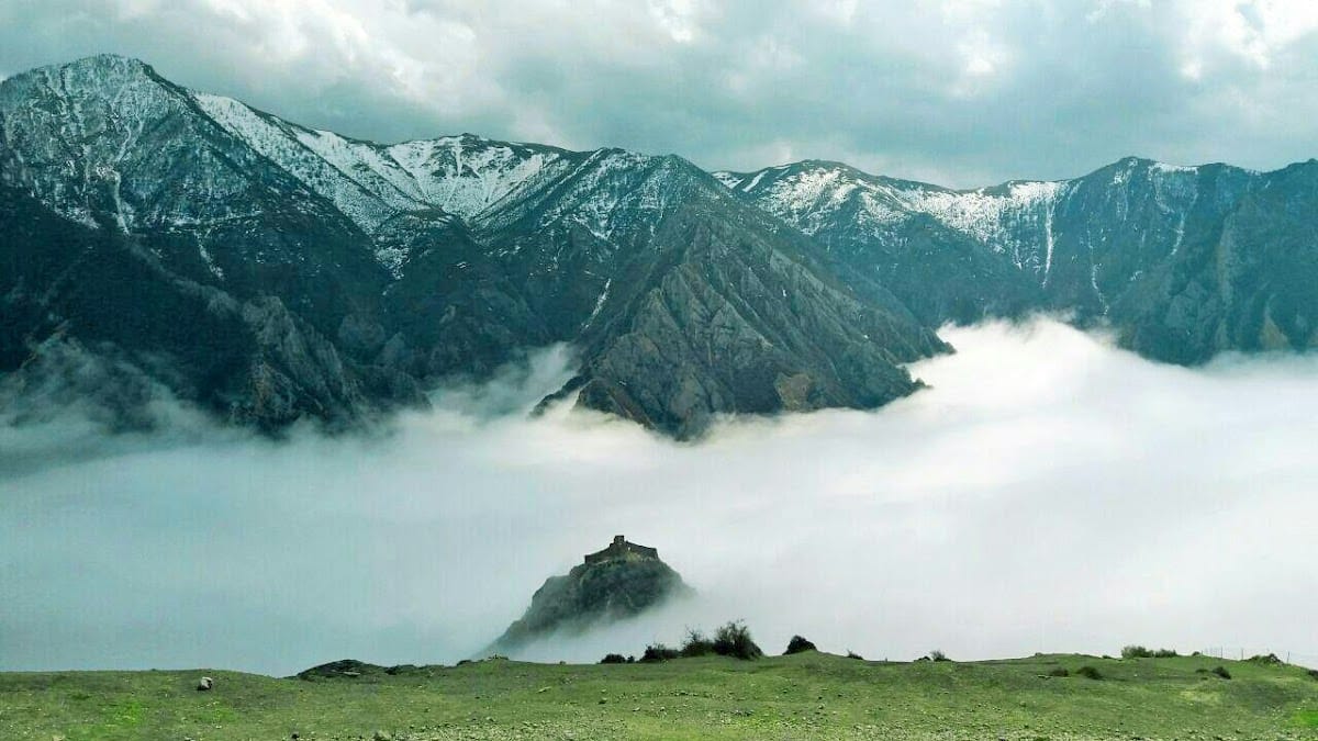
Kangelo Castle is a mountain fortress in Iran, generally dated to the Sasanian period, the era of the Iranian dynasty that ruled from 224 to 651. Located in Kangelo Village in Mazandaran Province, about 39 kilometres from Pol Sefid, it is regarded as part of the Central Alborz mountain-fortification system, alongside defensive sites such as Espahbod Khorshid Cave-Fortress and Darband Kola. The castle is approximately 1,500 years old, although its precise date and original purpose remain uncertain.
Origins and possible functions
Kangelo Castle appears to have had a military purpose. Its concealed position above an ancient valley, within a cleft of the Alborz Mountains, was suited to protection against sudden attacks, raiders, and foreign incursions. The fortress’s position and defensive arrangement helped control the only route into its steep, cone-shaped mountain.
Religious interpretations have also shaped the study of the site. Some proposals identify it as a sanctuary connected with Mithra, an ancient Iranian divinity associated with agreements, light, and the sun. Other interpretations place its construction in the early Islamic centuries or describe it as a Sasanian sanctuary dedicated to Anahita, an ancient Iranian goddess associated especially with water, fertility, and purity. The discovery of fat has been cited in support of the Anahita interpretation, while objects bearing Mithraic symbols have been used to argue for a connection with Mithra. Further proposals have described the structure as an astronomical building, memorial, royal pavilion, or recreational retreat. Archaeologists have not reached agreement on its original use.
Later historical setting
The castle apparently escaped destruction during the Arab attacks and the Mongol invasions. In the third century, after Arab forces defeated the Qarenid rulers, control of the mountain region passed to a Bavandid ruler. The Qarenids were a local Iranian ruling house associated with the mountain regions of northern Iran, while the Bavandids were a local dynasty that controlled parts of northern Iran for extended periods after the rise of Islam. The mountain was subsequently known as Shahriyar Kuh. During this period, Zoroastrian fire temples remained active in the mountains of Savadkuh while local rulers continued the religion of their ancestors.
Research and heritage
Manouchehr Sotoudeh and Iraj Afshar were among the earliest researchers to identify and study Kangelo Castle during the 1980s. Sotoudeh referred to the monument as Kangeli Castle and described a stone-and-plaster fortress on an isolated, steep, conical mountain beside a gorge.
Archaeological probing along the approach to the castle revealed evidence of human occupation from Iron Age III, the Sasanian period, and the early Islamic centuries. Iron Age III is an archaeological term for a late phase of the Iron Age in the Iranian region. The work also identified burials from the late Parthian and Sasanian periods and from the beginning of the Islamic period, including what was described as the first identified Sasanian burial in Mazandaran. In 1385 of the Iranian calendar, the castle’s excavator proposed that the structure might have been a sanctuary of water and Anahita. The monument was later placed on Iran’s national heritage register, with a listed identity combining a military fortress and a place associated with Mithra worship.
Remains
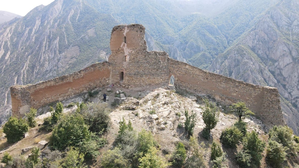
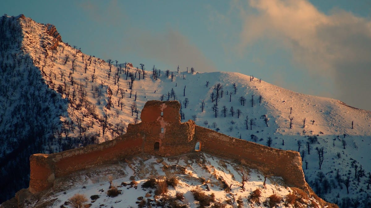
Kangelo Castle occupies a massive rock at approximately 1,811 metres above sea level. Its surviving plan is circular or elliptical, a distinctive form among Iranian fortifications. A large stone wall encloses the exterior, with watchtowers incorporated into its central section and two sides. Much of the structure has fallen into ruin, including most of the third interior level and a substantial part of the roof, but the remaining walls preserve the castle’s unusual defensive form.
Fortifications and interior levels
Outer walls and towers
The two side towers were built as solid masses to strengthen the fortification wall. They extend toward a large circular tower that served as the principal citadel, with a small entrance at the lower part of the central tower. The surviving exterior is dominated by two massive walls that spread outward like open arms. Together, these walls formed a defensive arrangement across the only approach to the steep, cone-shaped mountain.
Rubble stone, lime mortar, gravel, gypsum, and sarooj, a traditional waterproof mortar made chiefly from lime and other mineral materials, formed the principal construction materials. The building methods are associated with indigenous Alborz techniques and combine Parthian and Sasanian architectural features. The Parthian period was the era of the Arsacid dynasty, which ruled Iran before the Sasanians, approximately from 247 BC to AD 224.
Interior levels
The interior was originally arranged on three levels, although the surviving remains emphasize two principal stories. Excavation on the second level identified a central rectangular room flanked by two semicircular rooms. Work continued down to a floor made with gypsum mortar, which had been created by filling the first level.
Partition walls, vaulted ceilings, window arches, niches, and entrances form part of the recorded interior architecture. Technical surveys assigned individual numbers to these elements and recorded their depths and archaeological layers. The forms of the vaults have been compared with those at Espahbod Khorshid Cave-Fortress, Firuzabad Castle, the Sarvestan Palace, and the Takht-e Soleyman complex.
Water installations and burial evidence
Water-storage structures
Excavation brought to light quadrangular structures with plaster coating. These were interpreted as installations for storing water and other liquids. Their presence has contributed to the interpretation of the castle as a possible sanctuary associated with water and Anahita, although the wider purpose of the monument remains debated.
Burial and objects
A burial near the castle was constructed from rubble stone and clay mortar. The body was placed facing approximately west, with the knees drawn together near the body. This burial method was used from prehistoric times through the beginning of the Islamic period.
Several objects accompanied the burial, including an agate finger ring used as a seal and another ring bearing an inscription interpreted as a term associated with joy and blessing. A six-pointed sun design on one ring was identified as a Mithraic symbol. Another seal carried an especially finely carved motif. These finds contribute to the religious interpretations of the site while also reflecting the range of activity around the fortress across the late Parthian, Sasanian, and early Islamic periods.