Inka Wasi, Ayacucho: An Inca Administrative and Ceremonial Center
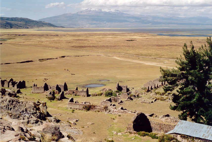
Site at a Glance
- Rating
- 4.5
- Popularity
- Very Low
- Country
- Peru
- Primary era
- Medieval
- Eras represented
- Medieval
- Civilizations
- Inca
- Site type
- City
On this page14 sections
History
Inka Wasi, meaning “Inca House,” was an Inca-period administrative, religious, ceremonial, and astronomical center near Lake Parinacochas in Ayacucho, Peru. Founded sometime between 1438 and 1493, probably during the reign of Pachacuti or his successor Tupac Yupanqui, it formed part of Kuntisuyu, the southwestern quarter of the Inca Empire.
Imperial Route and Administration
The settlement stood beside the route linking Cusco with the coastal port of Chala. Its position near Lake Parinacochas allowed it to serve as a tambo, an imperial roadside facility that provided lodging, supplies, and logistical support. The settlement probably accommodated imperial troops, the Sapa Inca, temporary tax collectors, and possibly chasquis, the relay messengers of the Inca road network.
Inka Wasi also operated as a redistribution point between the Pacific coast and the highlands. Marine fish from Chala passed through the settlement, while its storehouses held food, particularly maize. This logistical role connected coastal resources with the needs of travelers, officials, and imperial forces moving through the region.
Maize Festival and Astronomy
Inka Wasi hosted Sara Aymoray Raymi, the major festival celebrating the maize harvest. Delegations came from all four imperial quarters, Antisuyu, Collasuyu, Chinchaysuyu, and Kuntisuyu. The settlement was also associated with Mama Sara, an Inca deity of maize.
During Aymoray, approximately in May, the Sapa Inca, priests, and amautas, learned specialists connected with teaching and the preservation of knowledge, gathered at the observatory. There they made astronomical observations to establish the proper time for harvesting maize. A ceremony to consecrate an heir or co-ruler has also been proposed, although the supporting evidence is insufficient.
Decline and Modern Recognition
Inka Wasi declined during the struggle between Huáscar and Atahualpa in 1532. One explanation links the town’s destruction to the loss of care from the central government. Another proposes that deforestation increased aridity and encouraged the population to abandon the region.
The Peruvian archaeologist Antonio Raimondi visited the area in 1863, and Hiram Bingham explored Inka Wasi in 1922. During Bingham’s visit, an annual fair held in the third week of August used the principal plaza for market stalls. Looting by unauthorized excavators continues to threaten the preservation of the ruins.
Remains
Settlement and Main Buildings
Inka Wasi lies at approximately 3,300 meters above sea level in the Parinacochas basin, northwest of the lake, with Sara Sara volcano and the lake visible in the surrounding landscape. Surviving remains include foundations and remnants of up to about 20 buildings. Some foundations were later reused beneath houses in the Peruvian settlement of Incuyo.
Inca Buildings and Chullpa Towers
The Inca buildings had exterior walls covered with characteristic carved decoration. The site also preserves distinctive chullpa towers, monumental funerary structures with either angular or circular bases.
Astronomical Observatory
A small astronomical observatory survives in relatively good condition. Numerous Inca astronomical instruments were found there, connecting the structure with the observations made during the maize-harvest season.
Palace or Elite Lodging
Ruins of a palace associated with a kuraka, a local authority, survive at the site. Another interpretation identifies the building as lodging for the Inca’s heir, but its attribution remains uncertain.
Central Plaza and Former Temple
The central plaza was enclosed by a long building made of adobe and stone. Most of its stones were roughly cut, while others were carefully dressed; several loose stones weighed approximately half a tonne. A Catholic church was later built on the site of the former Temple of the Sun. Spanish chroniclers also described full-sized solid-gold sculptures of a maize ear and Mama Sara in the plaza.
Agricultural and Funerary Landscape
Terraces
Ancient agricultural terraces survive on the hillsides around the Parinacochas basin. Potatoes and other tubers were cultivated there in large quantities, showing the relationship between the settlement and the productive highland landscape.
Cave Burials
Burial chambers were found in caves on the hill west of the lake. Their adobe blocking walls had been partly broken open, and cave debris contained nine or ten detached skulls. One skull appeared to have undergone trepanation, a surgical procedure involving the opening of part of the skull.
Ancient Road
Remains of an ancient road follow the hilltops. Approximately 50 meters wide, the unpaved route formed a broad grassy passage through fields of loose stones and followed the direction of the lake across the ridge toward a wide valley with terraces and cultivated fields. Stones were probably piled along its sides to guide llama caravans across the rocky ridges.