Hekirichi Bastion Fort: A Matsumae Clan Defensive Outpost in Japan


Site at a Glance
- Rating
- 4.1
- Popularity
- Low
- Country
- Japan
- Primary era
- Early Modern
- External website
- Open
- Eras represented
- Early Modern
- Civilizations
- Tokugawa
- Site type
- Military
- Remains
- Fort
On this page13 sections
History
Hekirichi Bastion Fort is a Japanese fortified administrative center and defensive outpost built by the Matsumae clan in 1855 at Nozaki in Hokuto, Hokkaido. Constructed during the late Edo period, the era of Tokugawa shogunal rule from 1603 to 1868, it was Japan’s first fort to adopt a European-style, four-pointed star-shaped bastion plan. The fort guarded the Hakodate Plain and supported the shogunate’s administration in an area facing increased foreign contact.
A proposed stronghold for northern defense
The fort arose after the Edo shogunate assumed direct control of Ezo, now Hokkaido, and ordered the Matsumae clan to share responsibility for defending the Hakodate area. The shogunate’s Ezo Governance Agency and a port open to foreign countries were located there, making the region an important center of northern administration and military concern.
Nozaki had been regarded as a strong defensive position before construction began. Matsumae Hironaga, an elder of the clan and an Edo-period historian, praised the area’s defensive and scenic qualities in Matsumae-shi, prefaced in 1781. He proposed it as a possible new location for the clan headquarters. In 1807, the explorer and official Kondō Jūzō likewise recommended moving Ezo’s administrative center from Matsumae to Nozaki, describing the site as a strategically superior stronghold.
The name Hekirichi comes from the Ainu term peker-pet, meaning “beautiful river” or “bright river.” It refers to the area around the Hekirichi River west of the fort.
Construction and European military learning
On May 8, 1855, the shogunate ordered the division of guard territories and the construction of guard posts. The Matsumae clan selected Nozaki Hill on June 8 and petitioned the Hakodate Magistrate, the shogunate office responsible for administration and oversight in the area, to build the principal guard post for Hakodate’s defense. Approval came on June 10, the site was inspected on June 11, and work began immediately. The fort was completed on October 20, after only five months of construction.
Fujiwara Shume, also known as Fujiwara Jūta, designed the fort. A Matsumae clansman, he had studied Western military knowledge at Sakuma Shōzan’s Satsuki-juku academy. His training included European fortification methods, geometric calculation, and efficient construction techniques. Matsumae Takahiro, the clan lord, rewarded him with a permanent elevation in family status and two sets of seasonal clothing, an exceptional personal honor.
Hekirichi’s design drew on European bastion fortification and nineteenth-century theories of artillery defense. A bastion fort uses projecting points to let defenders fire along the faces of its walls and protect their flanks. Hekirichi’s four bastions formed a four-pointed star based on a square enclosure. The design was especially notable because bastion forts were already declining in Europe as changes in artillery warfare made them increasingly obsolete.
The original plan of the main bastion has not survived, but archaeological analysis in 2023 reconstructed its underlying geometry. The design used a square measuring 200 meters on each side, with the diagonals and bisectors serving as reference lines. It also used the metric system, which was not the standard surveying method in Japan at the time. The dimensions and angles closely correspond to a model in Nicolas Savart’s Cours élémentaire de fortification and its expanded Dutch translation by Frederik Petrus Gisius Nanning.
Savart’s ideas could reach Japanese students of Western learning through Dutch studies, an important channel for foreign scientific and military knowledge during the Edo period. The Dutch translation was among Sakuma Shōzan’s possessions, appeared in the library of Egawa Hidetatsu, was mentioned in correspondence by Date Munenari, and was listed in the architectural section of the Bansho Shirabesho catalogue. The Bansho Shirabesho was a shogunal institution established to study and translate foreign documents.
Garrison and administrative functions
Duty reports from 1859 list six-pounder short cannons, three-kilogram field guns, and thirteen-pound howitzers. Their range was considered sufficient to cover Nozaki Hill. A report submitted to the Hakodate Magistrate in 1861 recorded 27 cannons of four types at six gun positions, along with 59 rifles.
The garrison contained an estimated 120 to 160 people, including commanders, retainers, foot soldiers, and lower-ranking attendants who served on a rotating basis. The fort primarily guarded the Hakodate Plain and operated as a garrison. It also supplemented the Hakodate administration and Goryōkaku, the nineteenth-century star-shaped fortress in Hakodate, whose military capabilities were limited.
Hekirichi also performed some internal administrative duties. In 1864, it helped mediate approval for the residence of a person who had left their family register after moving from Kubota. Matsumae clansmen later settled with their families along the main approach, combining military service with agricultural work on the surrounding land.
The fort never engaged foreign forces after its completion. The later construction of 24 samurai residences along the main approach, together with surrounding earthworks proposed for soldier accommodation and agricultural reclamation, obstructed the view across the gentle approach slope. These changes substantially reduced the effectiveness of the fort’s artillery.
Destruction during the Hakodate War
After the Meiji Restoration in 1868, the political transformation that ended the Tokugawa shogunate and established imperial government, troops from Hekirichi were sent in rotation to help defend Goryōkaku. The deployments followed orders from Shimizutani Kinnaru, governor of Hakodate Prefecture. Takahata Kiroku, a Matsumae clansman who had moved to the fort with his family in 1862, served with the Goryōkaku defense force from July to September 1868.
The Hakodate War was the final phase of the Boshin War, the 1868 to 1869 conflict between forces supporting the new Meiji government and remnants of the Tokugawa regime. On October 22, 1868, the Hekirichi garrison sent reinforcements to Goryōkaku at the request of the Hakodate administration. It suffered defeat during the night assault at Tōge-shita on October 23 and at the Battle of Nanae on October 24, then withdrew without returning to the fort. A Matsumae spear-and-sword unit was also defeated at Ōno-guchi on October 24 and did not stop at Hekirichi.
On October 24, after seeing a patrol led by Takigawa Mitsutarō and Honda Koshichirō under Ōtori Keisuke, the few soldiers still at the fort set fire to its buildings and withdrew without fighting. Takigawa’s unit seized two cannons, 150 bales of rice, and other ammunition.
Ownership, preservation, and research
Ownership passed to the Iwafune family in 1900. The prominent Hakodate merchants were associated with the creation of Kōsetsu-en. In 1904, cherry trees were planted along the former main approach to commemorate Japan’s victory in the Russo-Japanese War. The resulting avenue helped establish the site as a renowned scenic place and contributed to its later preservation.
On March 18, 1965, the site became a National Historic Site of Japan under the category of castle ruins, with the official name “Site of Hekirichi Bastion Fort of the Matsumae Clan.” Kamiiso Town, now part of Hokuto City, acquired it as municipal property in 1977.
Archaeological excavation and environmental maintenance began in 1979 with national and prefectural subsidies. Excavation confirmed building remains that closely matched historical plans and recovered approximately 65,000 artifacts, mainly household objects from the late Edo period. The finds established the fort’s operation as a Matsumae clan outpost, although early investigations placed greater emphasis on its administrative than its military functions.
Park development followed the excavations and was completed in 2001. In 2007, Hekirichi Bastion Fort Park was included in the second selection of the 100 Historical Parks of Japan. Since 2018, continuing research by Tokita Taichirō has reassessed the fort’s relationship with European military theory. The first issue of the Hokuto City museum bulletin, published in January 2024, included a comprehensive study of this work.
Remains
Star-shaped earthworks and artillery defenses
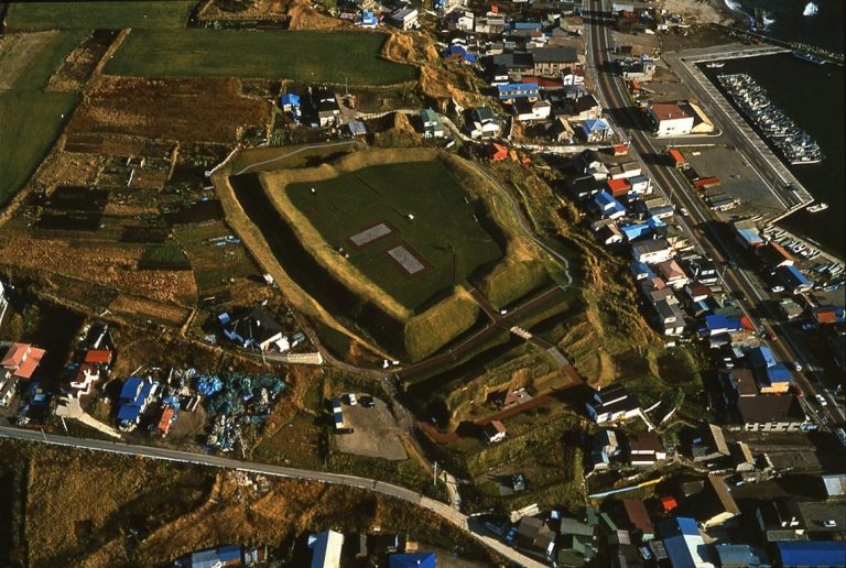
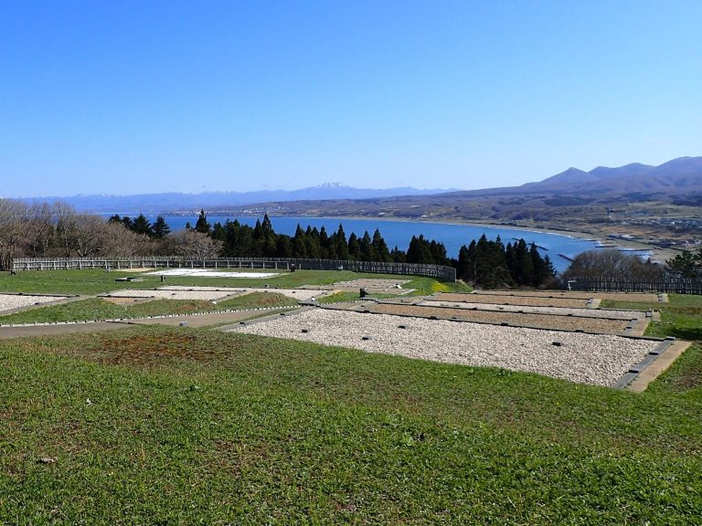
Hekirichi Bastion Fort occupies the base of Nozaki Hill, a tongue-shaped plateau approximately 5 kilometers northwest of central Hokuto. The main star-shaped bastion stands on the hill’s highest level ground. The Anatahira cliff lies to the southwest, mountainous terrain extends toward the Matsumae Peninsula to the north, and a ravine borders the northeast. Together, these features restrict approach to a long, gentle slope from the southeast.
The main fort is a four-bastion enclosure formed chiefly from earthworks and moats. It covers approximately 434,000 square meters, while the designated historic-site area covers 104,206 square meters. The broader Nozaki Hill area used to calculate the fort’s firing zone covers approximately 355,000 square meters.
The position of the main bastion, with cliffs and ravines on both sides and a gently sloping approach in front, follows the terrain principles of nineteenth-century European artillery fortification. Six gun emplacements were built on the eastern bastion. Along the ramparts, a continuous inner riflemen’s platform connects in profile with the surrounding moat.
Parapets and gun positions
The defensive works retain parapets, protective raised banks behind which soldiers and artillery could operate, together with outward-flaring embrasures, openings through which guns were aimed and fired. The flare widened the available field of fire. Gun-carriage platforms regulated the position of the weapons and prevented their movement from damaging the ground. The parapets may reach 10 meters in thickness at their bases.
The surviving artillery batteries preserve these parapets, flared embrasures, and gun platforms. The main bastion and its moats remain in near-original condition, allowing the defensive arrangement to be read as an integrated system of earthworks, water defenses, firing positions, and the surrounding terrain.
Inner enclosure and buildings
Historical diagrams and excavation indicate that as many as 17 buildings stood inside the inner enclosure. The earliest surviving plan shows 16 buildings, including four longhouses arranged in the center. Their uses included the commander’s officers’ quarters, quarters for retainers and a medical facility, an accountants’ office, and a barracks for lower-ranking foot soldiers and attendants. Room allocations changed during the fort’s operation.
Stores and garrison facilities
Other facilities included storage buildings for books, food, cannons, and firearms. The inner enclosure also contained a martial-arts training hall, stables, guardhouses, watchtowers, a bathhouse, wells, and rooms for intermediaries handling miscellaneous duties. Together, these structures supported the fort’s military, residential, logistical, and administrative functions.
Firearms-training ground
The earliest plan places a firearms-training ground at the western bastion corner. It included a firing shed, an earthen target mound, and a crank-shaped earthwork used to confirm hits. Excavation found another building crossing the former firing line, while the target mound and hit-confirmation earthwork were not preserved. The arrangement suggests that firearms training may have ended and that the area was repurposed during the fort’s operation.
Archaeological finds and later landscape
Approximately 65,000 recovered artifacts consist mainly of household objects from the late Edo period. Their distribution and character provide evidence for domestic and administrative occupation within the military outpost and complement the building remains identified through excavation.
The former main approach is lined with Meiji-period cherry trees commonly called the “Cherry Tunnel.” The avenue and the open spaces around the main bastion are incorporated into the historic park. The cherry planting, begun in 1904, gave the former fort a later scenic and cultural identity, while the surviving earthworks preserve its earlier defensive form.