Haltern: Roman Military Camps and Archaeological Complex in Germany
Site at a Glance
- Popularity
- High
- Country
- Germany
- Primary era
- Classical
- Eras represented
- Classical
- Civilizations
- Roman
- Site type
- Military
- Remains
- Camp
On this page28 sections
History
Haltern is a group of Roman military installations and related archaeological areas at Haltern am See, Germany, established during the Augustan period, the reign of Rome’s first emperor, Augustus. The camps stood north of the Lippe, a river route into Germania, the Roman name for lands inhabited by Germanic peoples. The complex began as a military presence and later developed administrative and commercial functions.
Augustan military presence along the Lippe
A temporary marching camp found in 2021 is thought to date to campaigns by Drusus, a Roman commander active in Germania, around 12 or 11 BC, although its construction date is uncertain. The larger field camp is also sometimes linked to Drusus’s campaign of 11 BC. The foundation date of the permanent main camp is unresolved. It was established after the nearby Roman camp at Oberaden had been abandoned by 8 BC. Proposed dates include 7–5 BC, during a reorganization after Drusus’s campaigns, or around the campaigns of Marcus Vinicius in 1–3 AD. Roman activity at Haltern around the turn of the era is certain.
The installations served different purposes, though the role of some remains unclear. Annaberg has been proposed as the earliest military camp in the group, but its unusual plan leaves its function unsettled. At Wiegel, an earlier interpretation of a landing place and storage buildings gave way to the possibility that the settlement remains belong to the canabae legionis, the civilian settlement associated with a legionary camp. At Hofestatt, four fortifications succeeded one another beside the river. The latest is identified as a fortified naval base; the earlier three may have included a landing place, but their uses are uncertain.
Changes to buildings and the provision of additional officers’ accommodation and workshops point to a gradual broadening of the main complex’s role. Pottery production eventually exceeded local needs, while trade connections extended along the Lippe and toward the Rhine. The soldiers stationed at Haltern are not known with certainty. A name scratched on a fine pottery plate, an inscription on a soldier’s grave marker at Forum Iulii, and a lead ingot from the main camp indicate that at least some members of the Nineteenth Legion were present. In its later phase, the camp may have housed six or seven cohorts, subdivisions of a legion, as well as auxiliary troops serving alongside legionaries.
The Varus defeat and the proposed identification with Aliso
The complex was probably abandoned in connection with, or after, the Varus disaster of AD 9, the Roman defeat in the Teutoburg Forest in which three legions were lost. The end of Roman occupation at Haltern remains disputed. Archaeological evidence allows for occupation or renewed use as late as AD 16, when Tiberius ended Rome’s offensives in Germania. Germanicus, a Roman commander who later campaigned there, may also have used the site during operations in AD 15–16.
Haltern has been proposed as the location of ancient Aliso, but the identification is unproven. The Roman historian Velleius Paterculus describes a garrison commanded by Lucius Caedicius resisting a Germanic siege at Aliso after the Varus defeat before escaping. Archaeological evidence at Haltern has made the proposed connection more plausible, but it remains unresolved. Tacitus also writes of a fort on the Lippe besieged in AD 16 and of Germanicus securing the area between Aliso and the Rhine with roads and embankments.
Archaeological investigation and protection
Haltern was first reported as an archaeological site in 1816, when judge Wesener informed Westphalia’s provincial president, Ludwig von Vincke, about three excavated burial mounds and Roman finds near Annaberg. The priest Joseph Niesert published a report on Annaberg finds in 1834. In 1838, Prussian major Friedrich Wilhelm Schmidt investigated routes used by Roman troops and identified remains of a Roman fort there.
Systematic excavations began in 1899 under Carl Schuchhardt and Alexander Conze. Friedrich Koepp directed investigations at Haltern until the First World War, including work at Hofestatt with Hans Dragendorff and Gustav Krüger from 1901 to 1904. Excavations resumed on a larger scale in 1935 as building activity increased, with August Stieren, Erich Gose, and Christoph Albrecht among those involved. Work restarted in 1949 under museum director Heinrich Bleker and archaeologist Hans Aschemeyer, alongside Gose and Wilhelm Winkelmann. Later researchers included Klaus Günther and Klemens Wilhelmi. Continuing fieldwork has expanded understanding of the site amid encroaching construction.
The cemetery on Annaberg’s eastern slope was investigated in 1925 and 1932, and another grave was found there in 1958. Discoveries farther east led to excavations from 1982 to 1988, which uncovered 32 more graves. The East Camp was identified in 1997. A further marching camp had been indicated by aerial archaeology by 2011, before its ditch was located in 2021. The present LWL Roman Museum, opened in 1993, succeeded a Roman-Germanic museum established in 1900 and opened in 1907. Archaeological areas at Haltern are registered as archaeological monuments and protected under North Rhine-Westphalia’s monument-protection law of 13 April 2022.
Remains
The archaeological complex occupies the Lippe plain, which is bordered by the Haard to the south, the Hohe Mark to the northwest, and the Borkenberge to the northeast. The Lippe has changed course repeatedly; in Roman times it flowed farther north than it does today. Hofestatt’s riverside forts stood just north of the river, while other installations occupied higher, flood-safe ground. The remains include timber-and-earth defenses, camp interiors, burial grounds, and production areas.
Annaberg plateau
The Annaberg plateau rises as much as 30 m above the Lippe valley. A ditch found in 1899 may have enclosed a camp of about 7 hectares with a roughly triangular or heart-shaped plan. The ditch was 3.5 m wide and 1.5 m deep. Traces behind it have been interpreted as an earth-and-timber rampart, a raised defensive bank, about 4 m wide and 1.5 m high, reinforced by posts set roughly 30 cm apart. Other evidence may indicate towers at intervals of about 30 m, some possibly beyond the rampart.
Two possible gates on the northeast and northwest sides have been inferred from earth bridges flanked by towers. Their proposed gatehouses would have extended across the ditch, and the gates may have had double doors. The defensive layout remains uncertain: later archaeologists challenged Schuchhardt’s interpretation, and the remains have been heavily disturbed.
Wiegel terrace
At Wiegel, excavations covered a strip of ground about 300 m long and 60 m wide, north of a terrace edge above the Lippe floodplain. A boundary ditch ran for about 220 m and became shallower and narrower toward the east. At its western end it turned south and met three pits, each 3–7 m wide and of varying length, whose arrangement gave the group the name Triangle. Eight V-shaped ditches crossed the area. West of the pits stood a 13 m by 18 m building in an Italic style, with a partly open frontage facing south toward the Lippe. An amphora fragment found in the area bears a graffito dating it to the second consulship of the future emperor Tiberius, in 7 BC.
The Hofestatt river forts
Four successive fortifications at Hofestatt had timber-and-earth ramparts and ditches that ended at the steep riverbank, leaving the enclosures open toward the Lippe.
Earliest fort
The smallest fort measured about 43 m by 10 m. Its ditch was roughly 2 m wide and 1 m deep, with a doubled section on the eastern half. Behind it stood a timber-and-earth rampart about 3 m wide.
Second fort
The second enclosure surrounded the first on a larger scale. Its straight northern side ran for about 115 m before turning south toward the river at both ends. A ditch and timber-and-earth rampart defended it. Postholes at the northeast corner may mark a tower, while an earth bridge about 3 m wide at the center of the north side may have served as a gate. Two building traces lay inside near this entrance.
Third fort
The third fort appears to have been revised while it was being built. Its planned boundary extended more than 220 m northeast from the predecessor’s southwest corner. A double ditch and timber-and-earth rampart were traced along about 75 m of its western side. Farther on, the outer ditch continued, and an earth bridge suggests a planned gate. The completed fort was much smaller than intended: it turned southeast toward the river, covered about half the area of the second fort, and overlapped its western half. A gate and traces of small buildings lay on its northeast side.
Latest fort and boat sheds
The largest and latest fort began about 90 m west of the others at the riverbank. Its paired ditches and timber-and-earth rampart ran north, turned east at a right angle, and joined the eastern ditches of the third fort. A gate on the western front crossed the ditches on an earth bridge about 3 m wide. In the northwest corner, a 55 m by 30 m building complex opened toward the Lippe and contained traces of seven parallel boat sheds, each about 30 m long and a little over 6 m wide.
Camps on higher ground
Field camp
The field camp stood on a rise as much as 30 m high, northwest of Wiegel and Hofestatt. It was approximately pentagonal, measuring about 614 m by 560 m and enclosing roughly 34.5 hectares. Its ditch was 1.6 m deep and up to 2.8 m wide. Gates were identified on the north, east, and south sides. A zone roughly 3 m wide, with no finds, lay just inside the ditch and suggests a rampart. The northern ditch’s cultural layer contained substantial charcoal, slag, and Roman material. Its ditches cut through at least three earlier installations.
Main camp defenses and layout
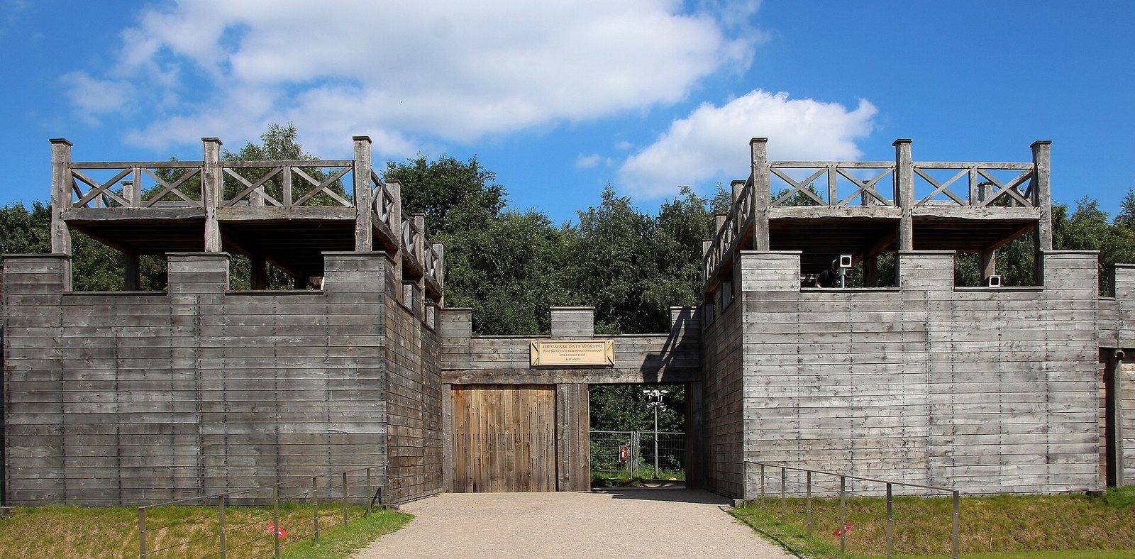
The main camp initially enclosed about 19 hectares, measuring roughly 500 m by 380 m, with its long axis running west-southwest to east-northeast. An eastern extension added about 60 m, bringing the area to roughly 20.1 hectares and the overall dimensions to about 560 m by 380 m. Two ditches, 5.5 m and 6 m wide and 2.5 m deep, surrounded it. A 2 m berm separated them from a timber-and-earth rampart about 3 m wide and probably more than 3 m high. Four gates had passages 7–10 m wide. The west, south, and east gates stood near the centers of their sides; the north gate lay near the northwest corner at the site’s highest point. Additional defenses were found at the south and east gates. A posthole near the west gate may mark a tower.
Main-camp roads
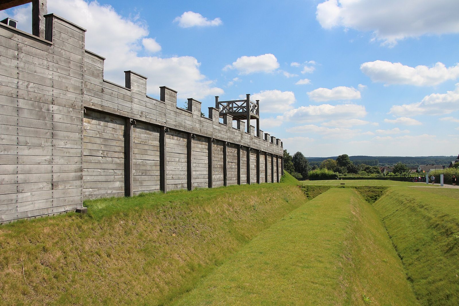
Five principal roads and parallel secondary roads formed an approximately rectilinear network inside the camp. The via praetoria, a major cross street, was more than 45 m wide; the via principalis, the main road, was about 30 m wide. The rearward road and cross street reached widths of up to 20 m. Another road ran inside and parallel to the rampart. A stretch of nearly 156 m of the western rampart, including the west gate, has been reconstructed in place in the Roman construction area beside the LWL Roman Museum.
Headquarters and officers’ buildings
The camp’s central headquarters building measured about 49 m by 54 m and projected into the main road with an entrance hall. Inside, a courtyard was bordered by colonnades, with a transverse hall and a row of rooms at the northern end. The commander’s official residence and workplace stood to the north and may have included a large colonnaded courtyard to the west. Houses for military tribunes were beside these headquarters and command buildings.
Workshops, hospital, and barracks
East of the headquarters stood buildings identified as workshops because numerous tools were found there. South of the main road, a courtyard building measuring 80 m by 44 m was interpreted as a military hospital. Barracks with shared soldiers’ rooms and centurions’ quarters occupied ground east of the hospital and especially the rear of the camp. Some later, more prestigious buildings extended into the streets.
East Camp
The East Camp occupied a hill crest in the area now known as the Münsterknapp industrial area and had an irregular plan. A medieval defensive earthwork later reused its ditch in the northeast. On the northwest side, a clavicula gate used a curved defense that forced entrants to turn sharply as they passed through. Excavations inside uncovered field baking ovens, refuse pits, and a barrack measuring 3.5 m by 5 m.
Marching camp
The marching camp discovered in 2021 has an estimated area of about 24 hectares. It may have accommodated as many as 20,000 legionaries.
Cemetery and burials
The cemetery extended for nearly 500 m along a strip about 45 m wide, from the southeast corner of the field and main camps toward Annaberg, on both sides of a Roman road. More than 100 Roman cremation graves are known. Cooking pots served as urns, and grave goods included animal bones, small perfume-oil bottles, occasional amphorae, jugs, other vessels, and nails from footwear and funeral beds. Women and children were among those cremated.
About 30 percent of the graves contained beds with elaborate bone carving, sometimes covered with gold leaf. Such burials were exceptional north of the Alps and point to Italic influence. Roughly half the graves had partly monumental markers or large burial mounds, some up to 15 m in diameter.
Pottery production and the human remains
Kilns and workshops
A pottery-production area discovered in 1991 lay south of the main camp, in front of its main gate, and probably continued beyond the excavated ground. It included ten kilns and building traces. The kilns were shaft furnaces with perforated floors, round or rectangular firing chambers, and rectangular working pits. In some, parts of the floors and lower firing chambers survived to depths of 2 m. Fieldstones formed the pits and chambers; their inner surfaces were coated with clay mixed with crushed brick. The domes were probably made from wattle covered in clay.
Human remains in a work pit
A work pit in the pottery area held the remains of 24 people and a dog beneath pottery waste. Sixteen of the people were identified as men aged 20–50. Their remains appear to have been discarded rather than formally buried. Isotope analysis indicates that six individuals came from the region and four from Bohemia or the Black Forest. They may have belonged to two Germanic groups. Their date is uncertain, and a connection with fighting after the Varus defeat, possibly the siege traditionally associated with Aliso in the winter of 9–10 AD, has been suggested.
Objects and other archaeological features
Finds from the camps
Finds from Haltern include four gold, 309 silver, and 2,561 bronze coins, along with lead water pipes, tent pegs, lamps, candelabra, locks, and keys. Pottery ranges from fine wares to everyday vessels, while glass includes colored and patterned pieces. Tools include axes, hoes, tongs, sickles, hammers, saws, drills, molds, and anvils. Military equipment includes daggers, a helmet, shield fittings, sword scabbards, arrowheads, sling bullets, heavy javelins, lance points, catapult bolts, and fetters. Other finds include medical instruments, jewelry, horse fittings, gaming pieces, and small cult vessels and figurines.
Pottery forms and paired dishes
Haltern is a type site for Italian-style terra sigillata, fine Roman pottery with smooth, often glossy surfaces and molded decoration. The name Haltern, or HA, remains in use for forms classified by ceramic specialist Siegfried Loeschcke. Chemical analysis has identified pottery from the La Muette workshop in Lyon, as well as from Pisa and Arezzo. Matched sets of dishes, paired by their shapes and profiles, were first described at Haltern; four types were identified, with the third and fourth treated as variants of the first two.
Temples and sacrificial pit
Excavations in 2023 uncovered features inside the larger military camps that were interpreted provisionally as two temples and a sacrificial pit. Their identification remains to be verified.