Gunung Padang Megalithic Site: A Prehistoric Terrace Complex in Indonesia
Site at a Glance
- Rating
- 4.6
- Popularity
- Medium
- Country
- Indonesia
- Primary era
- Unclassified
- External website
- Open
- Eras represented
- Unclassified
- Civilizations
- Unclassified
- Site type
- Religious
- Remains
- Sanctuary
On this page17 sections
History
Gunung Padang Megalithic Site is a prehistoric megalithic complex near Karyamukti in West Java, Indonesia. Built from large volcanic stones, it occupies a hill about 50 kilometres southwest of Cianjur and is associated with a sequence of proposed dates ranging from the first centuries BCE and CE to much earlier periods. Its original function remains uncertain, although it has been linked to animist worship and possibly to meetings among local leaders.
Sacred traditions and local memory
Gunung Padang remains sacred to Sundanese communities, an ethnic and cultural group concentrated in western Java. Local traditions describe the hill as a place for meditation and as a meeting point between the human and supernatural worlds. The stones are associated with ancestors, spiritual power, and regional traditions. In Sundanese, the name Gunung Padang is commonly understood as “Mountain of Light” or “Mountain of Enlightenment.”
Sundanese tradition attributes the construction to King Siliwangi, a legendary ruler-figure connected with the Pajajaran kingdom. According to the story, he attempted to build a palace in a single night. This account belongs to local cultural tradition rather than an independently established history of construction. Myths surrounding the site have also entered forms of locally rooted Islamic religious teaching that combine regional traditions with Islamic principles.
Proposed dates and early descriptions
The date of construction and the development of the terraces remain disputed. Lutfi Yondri proposed a date between the second and fifth centuries CE, while Harry Truman Simanjuntak placed the site in the sixth to eighth centuries CE. Pottery fragments found at Gunung Padang were dated by the Bandung archaeology bureau to approximately 45 BCE to 22 CE, providing evidence for activity in that period without resolving the date of the stone complex itself.
Much earlier chronologies were proposed by Danny Hilman Natawidjaja and associated researchers. Their interpretations placed initial construction between approximately 25,000 and 14,000 BCE, followed by proposed building phases around 7900–6100 BCE, 6000–5500 BCE, and 2000–1100 BCE. Other statements from the same research group described the site as more than 10,000 years old, approximately 24,000 years old, or as much as 27,000 years old. These claims have remained highly controversial and are not accepted by much of the academic archaeological establishment.
M. De Corte described the site after visiting it in 1890, and the Dutch geologist and historian Rogier Verbeek mentioned it in 1891. In 1914, the Dutch archaeologist Nicolaas Johannes Krom reported a hilltop structure that he considered approximately 2,500 years old. He suggested that the stone columns might indicate a burial place because he perceived similarities with remains at Hindu temples elsewhere in the Indonesian archipelago.
Rediscovery and archaeological investigation
After Krom’s report, Gunung Padang received little attention until local farmers rediscovered it in 1979. The rediscovery led to investigations by the Bandung Institute of Archaeology, the Directorate of Antiquities, PUSPAN, the local government, and community organizations. Joint archaeological research and restoration continued during the 1980s. The fifth terrace was identified in 1981, and work by the National Institute of Archaeology in 1985 contributed to restoration.
Excavations in 2002 led researchers to describe Gunung Padang as an early form of stepped-pyramid or stepped-terrace architecture. A stepped terrace is a monument made from successive raised platforms rather than a single smooth-sided structure. This interpretation shifted attention from the earlier suggestion of a burial site toward the organization and construction of the terraces.
Petrographic research in the 1990s by the West Java Archaeological Center suggested that the stone columns came from a local volcanic source north of Gunung Padang. The Indonesian Ministry of Education and Culture recognized the site as a locally significant cultural-heritage site in 1998. In June 2014, it was declared a National Site Area covering 29 hectares.
The 2011–2014 controversy
In 2011, President Susilo Bambang Yudhoyono’s special task force promoted renewed investigation. The team included geologists from the Indonesian Institute of Sciences, archaeologists from the University of Indonesia, military personnel, and other participants. From October 2011 to October 2014, Natawidjaja led combined archaeological, geological, and geophysical research that interpreted the hill as a complex, multi-period buried structure rather than simply a stone terrace.
The investigation drew strong criticism from archaeologists and other scholars. They argued that stone columns had been removed without adequate contextual records, archaeological layers had not been properly studied, and deposits might have been damaged. A proposed mass excavation involving 500 volunteers in 2013 was protested by members of the archaeological community. Thirty-four Indonesian archaeologists and geologists petitioned President Yudhoyono in October 2014, warning that the methods endangered an important archaeological site.
The dispute involved archaeological method as well as political, religious, financial, and national-identity questions. The investigation was suspended in 2014 amid methodological criticism, political controversy, and a change of government. Excavation activity was temporarily halted on 1 October 2014.
Continuing debate
Volcanologist Sutikno Bronto has interpreted Gunung Padang as a volcanic formation. In his view, a cavity within the mound represents the crater of an ancient volcano rather than evidence of an artificial pyramid. Other scholars have rejected Natawidjaja’s interpretation as unsupported or pseudoarchaeological. Critics have also pointed to nearby cave tools made from human bone and dated to approximately 9,500 years ago, arguing that this evidence does not support the existence of a more technologically advanced civilization 20,000 years earlier.
A 2023 paper by Natawidjaja and colleagues claimed that Gunung Padang was the world’s oldest pyramid and could date to 27,000 years ago. The paper was retracted in March 2024 because its radiocarbon dates came from soil samples that were not securely associated with artifacts or features demonstrably made by humans. The retraction stated that the interpretation of a pyramid built 9,000 or more years ago was incorrect.
A 2025 mineralogical study examined the site’s hexagonal stones and the material between them. It reported differences between volcanic minerals in the stones and minerals formed by hot, chemically active fluids in the fill. Gaps of approximately 7–10 centimetres between stones were presented as evidence supporting human construction rather than a wholly natural formation. These findings do not by themselves establish the disputed early chronology.
Remains
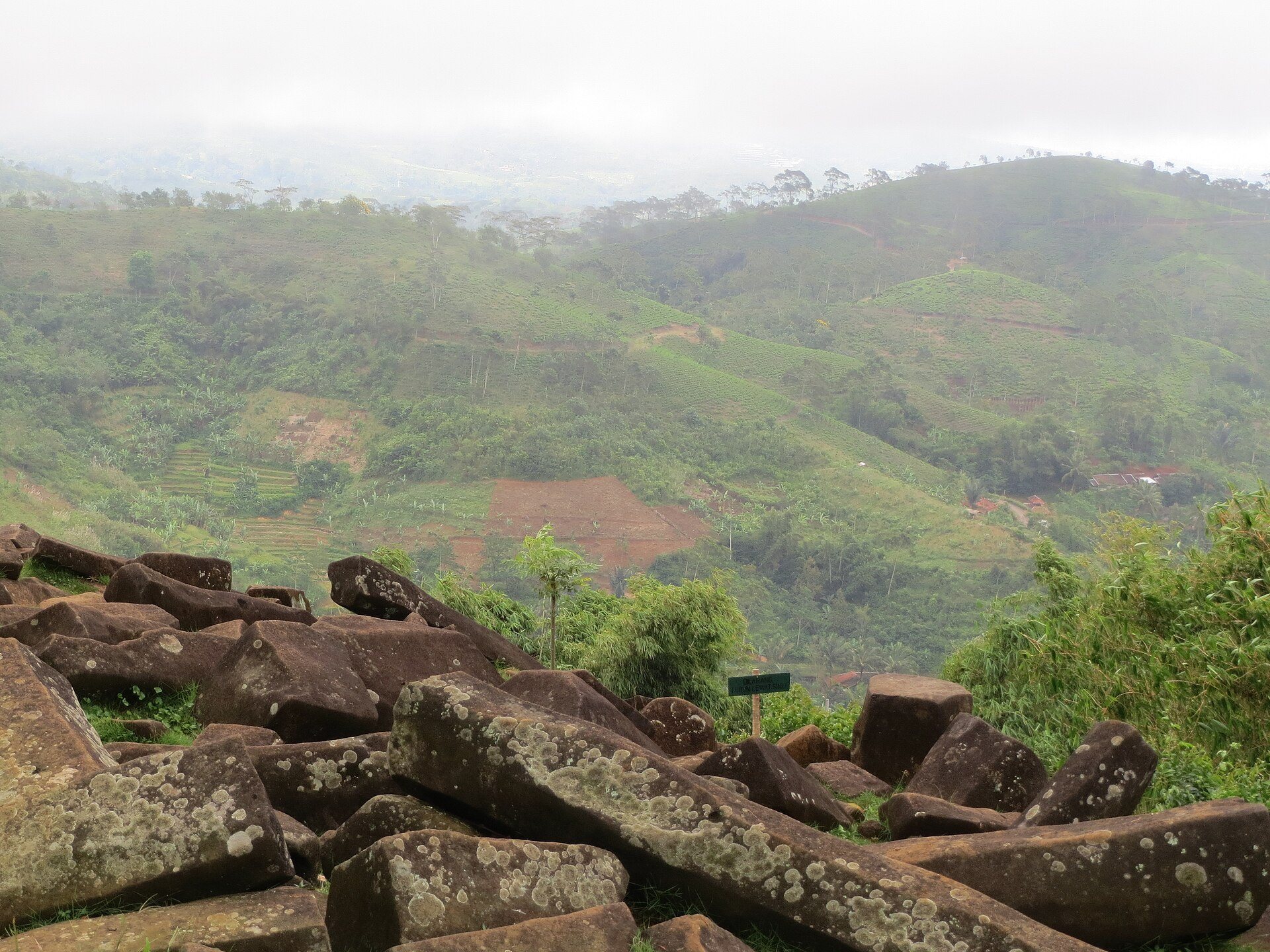
Gunung Padang occupies a hill about 885 metres above sea level in a region of steep-sided hills between approximately 800 and 1,200 metres high. The site lies near the edge of a deeply eroded circular basin, on the end of a narrow ridge extending south toward Gunung Empet, and faces the active volcano Gunung Gede to the northwest. The surrounding landscape includes Gunung Malang, Pasir Domas, Pasir Pogor, and the nearby stepped site of Lebak Cibedug.
Terraces and stone arrangements
Five raised terraces
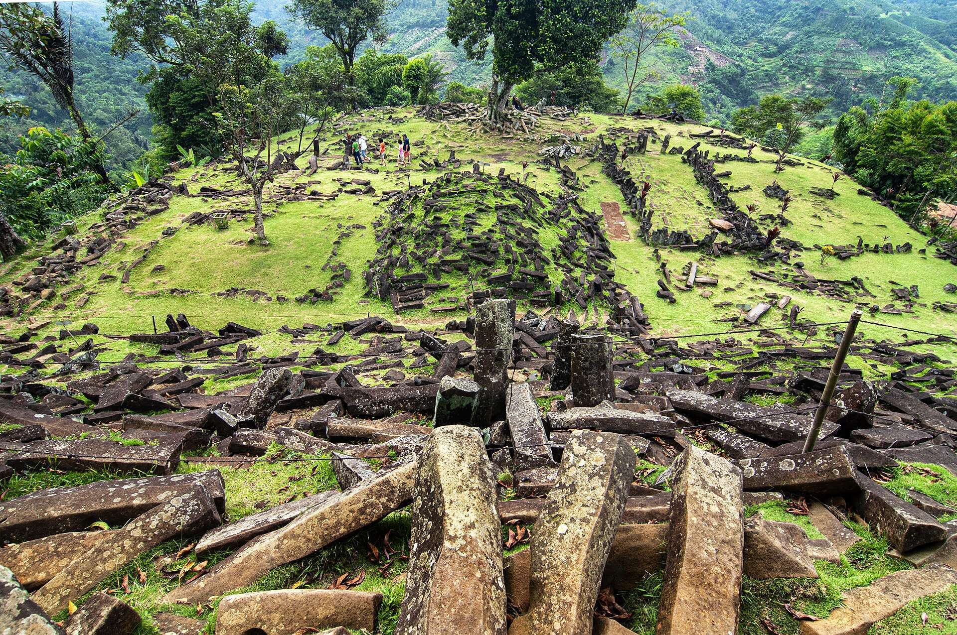
The complex covers approximately 3,132 square metres and rises about 95 metres from its access point. Five terraces occupy progressively higher levels along a central northwest–southeast axis. The lowest and largest terrace is rectangular, while the four upper terraces are approximately trapezoidal and become progressively smaller. The platforms were formed by lowering elevated ground and filling depressions to create level surfaces.
Retaining walls and stairway
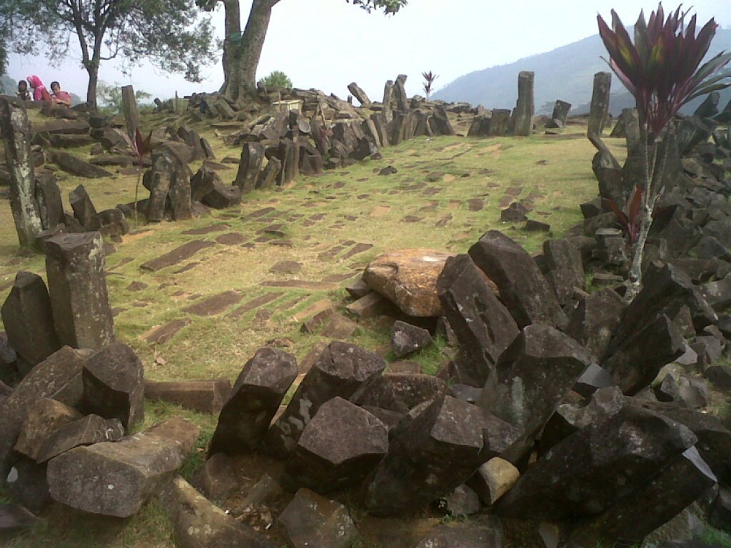
Retaining walls around the terraces were built from volcanic polygonal stone columns. Some columns lie in horizontal stacks, while others stand vertically as posts. A central stairway connects the terraces through approximately 370 andesite steps. It rises at an angle of about 45 degrees over a length of approximately 110 metres.
Columns, paving, and open spaces
The terraces and their surroundings contain massive volcanic columns that are generally polygonal or hexagonal, with some described as having three to six sides. Reported lengths range from approximately 1 to 3 metres. The stones form walls, paths, open spaces, terrace edges, and other megalithic arrangements. Rectangular slabs are scattered across the site, while some survive in large rectangular formations or as paving associated with a collapsed structure. In some descriptions, only the upper terrace is clearly exposed, while soil and vegetation partly cover the lower terraces.
An account from 1890 described four connected terraces paved with rough flat stones and decorated with upright, pointed andesite stones. It also mentioned a small mound on each terrace, surrounded and covered by stones and topped by two pointed stones. Those mounds were regarded as possible burial features at the time, while later investigation described the wider complex as stepped-terrace architecture.
Volcanic setting and construction materials
Gunung Padang stands on hydrothermally altered volcanic rocks. Hydrothermal alteration is the chemical transformation of rock by hot, mineral-rich fluids. The local bedrock consists of alternating lava flows and volcanic breccia intruded by andesite, and includes quartz, pyrite, and kaolinite. The resulting foundation is structurally weak. The upper hill consists of andesite porphyry with well-developed vertical columnar jointing, the natural formation of polygonal rock columns as volcanic rock cools and contracts. Plagioclase and pyroxene crystals are enclosed in a fine-grained volcanic-glass groundmass.
The naturally formed columns were used as ready-made blocks in the terraces. Columns on the eastern side are relatively little weathered, while those on the western slope have undergone spheroidal weathering. Some have weathered into reddish-brown clay, and others carry clay crusts. These crusts were once mistaken for artificial mortar but are described as natural weathering rinds formed along the columnar joints.
The hill lies within the deeply eroded caldera of the inferred Karyamukti composite paleovolcano. A caldera is a large volcanic depression formed when part of a volcano collapses. The site is near the intersection of the Cimandiri and Gede–Cikondang faults. Regional bedrock includes basaltic-andesite volcanic rocks classified as tuffaceous breccia, lava, sandstone, and conglomerate, together with the Homblenda Pasir Pogor Andesite Intrusion, assigned an age of approximately 32.3 ± 0.3 million years through potassium–argon dating.
Geological instability
Hydrothermal weakening of the foundation contributed to a partial summit collapse during the Late Pleistocene, before construction of the archaeological complex. Ancient landslide deposits occur beneath the western, upper eastern, northern, and northeastern parts of the hill. These landslides tilted the long axes of some stone columns so that they run parallel to the slopes. The unstable geological foundation continues to threaten the surviving remains.
Buried construction phases
Proposed construction units
The Natawidjaja-led investigations interpreted Gunung Padang as four construction units formed during different periods and in different architectural styles. In that interpretation, Unit 4 is a carefully shaped mass of andesitic lava at the core. Units 3, 2, and 1 successively enclose or cover it. The proposed sequence places Unit 4 in the Late Pleistocene, Unit 3 around 7900–6100 BCE, Unit 2 around 6000–5500 BCE, and Unit 1 around 2000–1100 BCE. The chronology and the artificial character of these buried units remain disputed.
Buried layers and spaces
Within the same interpretation, Unit 3 was deliberately buried beneath soil, Unit 2 was later covered to a depth of approximately 1–3 metres, and the upper layer was formed from horizontal arrangements of basaltic columns. These arrangements were understood as stepped terraces, walls, paths, and enclosed spaces. A proposed third layer consists of densely arranged rock fragments extending to approximately 15 metres below ground and resting on a massive, fractured tongue of basaltic lava.
Ground-penetrating radar, multichannel resistivity, seismic tomography, deep-borehole data, and excavation were reported to indicate large spaces or chambers beneath the terraces. At least three were described as having straight sides and roughly square internal forms. Their origin and function remain debated, and the reported spaces have not resolved the wider disagreement over whether the buried formations are human-made, geological, or the result of both processes.
Condition and pressures
Erosion, weathering, unstable foundations, dense vegetation, burial processes, and visitor pressure threaten the site. Authorities have expressed concern about damage caused by visitors and have attempted to limit access. At the same time, Gunung Padang continues to provide cultural and economic benefits for nearby communities.