Fort Médoc: A Vauban Fortress Guarding the Gironde Estuary


Site at a Glance
- Rating
- 4.2
- Popularity
- Low
- Country
- France
- Primary era
- Early Modern
- External website
- Open
- Eras represented
- Early Modern, Modern
- Civilizations
- French
- Site type
- Military
- Remains
- Fort
On this page16 sections
History
Fort Médoc is a seventeenth-century military complex at Cussac-Fort-Médoc in France, built under Louis XIV as part of Vauban’s system of river defence. Constructed between 1689 and 1694 in the period of Louis XIV’s frontier fortifications, it formed one element of a defensive “lock” protecting Bordeaux from attacks along the Gironde estuary, together with Fort Paté on an island and the Citadel of Blaye on the opposite bank.
The Gironde defence system
The Gironde supported Bordeaux’s commercial prosperity from the Middle Ages, but the same waterway allowed hostile fleets to approach the city. Viking incursions and conflicts associated with the Hundred Years’ War, a long series of struggles between the English and French crowns, demonstrated the military danger of the estuary.
During the Fronde, the civil conflicts that challenged the French monarchy between 1648 and 1653, Claude de Rouvroy, Duke of Saint-Simon and governor of Blaye, repeatedly proposed closing the river route against attack. After inspecting the area in 1685, Sébastien Le Prestre de Vauban, Louis XIV’s principal military engineer, adopted the idea. His plan strengthened Blaye, placed Fort Paté in the centre of the estuary, and established Fort Médoc on the left bank.
Louis XIV approved the plan and ordered the new fort’s construction. Earthworks began in 1689, followed by the buildings in 1691, and the complex was completed in 1694. Its design formed part of Vauban’s wider programme of defence, which adapted older strongholds and created new fortifications in response to improvements in artillery. Fort Médoc was intended to control navigation toward Bordeaux and reinforce royal authority. Its position also allowed it to collect tolls and customs duties from vessels travelling upriver.
A limited military career
Although its strategic purpose was substantial, Fort Médoc never came under attack. In 1716 it possessed thirteen guns of six- and eight-pounder calibre, along with few cannonballs. By 1789, its garrison had been reduced to a small number of men, mostly invalid soldiers, and only three old guns remained.
The chapel ceased to serve as a religious space after the French Revolution and became an artillery store. Before that change, chaplains provided religious and moral support to the garrison, while the parish priest of Cussac celebrated Mass. Disputes over funerals arose because burials had to take place in the parish cemetery rather than within the fort.
Decommissioning and preservation
The army decommissioned Fort Médoc in 1916. The commune of Cussac acquired it in 1930 after periods of abandonment and restoration. In 1956, a local Médoc property owner sought to buy the Royal Gate for installation at his estate. The mayor and municipal council opposed the sale, beginning the process that led to the fort’s protection as a historic monument.
Fort Médoc was partially registered as a French historic monument in 1956, partially classified in 1968, and classified throughout in 2008. That same year it joined the UNESCO World Heritage property “Fortifications of Vauban,” together with the Citadel of Blaye and Fort Paté, under cultural criteria concerning artistic achievement, the exchange of military ideas, and the development of fortified architecture.
After the site had stood abandoned for about thirty years, the Friends of Fort Médoc association began working with the municipality on its rehabilitation in 1996. The chapel was reconstructed in 1994 by the municipality, the association, and stonecutting trainees from the AFPA, a French adult vocational-training organization. The bakery followed in 2002, while the guardhouses, chaplain’s house, powder magazine, and water-storage installation were progressively repaired and conserved.
Remains
Ground plan and outer defences
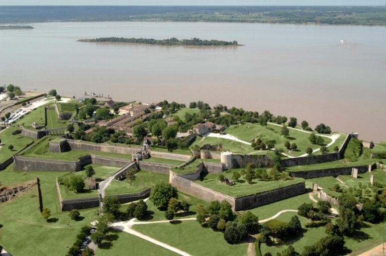
Fort Médoc occupies approximately 25 hectares on low, alluvial sandy ground beside the Gironde. The land was marshy, surrounded by wet meadows, and vulnerable to flooding at high tide. Ferry first raised and stabilized the ground. Because the soil remained unstable, the fort was built on an artificial island surrounded by ditches, without a general underground installation.
The fort has a trapezoidal plan set perpendicular to the river bank. Four corner bastions, projecting angular structures that allow fire along adjoining walls, are linked by curtain walls, the connecting sections between neighbouring bastions. Around this core lay an earth embankment about two metres high, a narrow water ditch, and a wider outer ditch several dozen metres farther away. Locks connected the floodable ditches to the river.
The broad ditch created a small island before the entrance. Bridges led across the defensive waterworks, while a half-moon, a detached crescent-shaped outer work, protected the approach. A covered way, meaning a protected path outside the main ditch, and an additional fore-ditch strengthened the entrance area.
The entrance and river defences
Royal Gate
The Royal Gate faces west and remains the fort’s only principal access. Designed to express the authority and prestige of Louis XIV’s monarchy, it was decorated by the Bordeaux sculptor Pierre Berquin. Its pediment bears the figure of the Sun King. In the curved tympanum, the field enclosed within the mouldings of the pediment, two kneeling atlantes support a royal shield. The shield carries three fleurs-de-lis, a crown, and the chain of the Order of the Holy Spirit, a major French chivalric order founded in the sixteenth century. The dove descending from its medallion represents the relationship between spirit and matter, while the atlantes symbolize enemies crushed by royal military power.
The ceremonial appearance concealed a heavily defended passage. A massive oak door opened into a vaulted corridor once closed by a portcullis. A second door with open cross-bracing allowed defensive fire, and loopholes, narrow firing openings, lined both sides of the passage. Defenders could fire from side rooms beneath the lateral stairways. The entrance therefore combined an outer wooden door, the portcullis operated from an upper organ chamber, and the loopholes along the corridor. The former wicket gate in the cross-braced door has disappeared.
Sea Guardhouse
The Sea Guardhouse stands opposite the Royal Guardhouse beside the river. Built between 1691 and 1694 on a raised platform about two metres high, it served as the principal observation and river-defence installation. Its lower level is sealed. Above it, a semicircular arcade faces the fort, while loopholes face the river. Two broad, symmetrical stairways lead to the upper platform.
Inside was a vaulted armoury containing the fort’s guns. The river-facing battery pointed toward Blaye, and an earth bank around the building helped protect it from floods and storm surges. Before a protective dyke was built, the room of arms was regularly flooded. Graffiti carved by members of the garrison remains visible in the stone.
During peacetime, the building also operated as a customs and toll station for vessels bound for Bordeaux. A small landing place beside it supported communication with Fort Paté and Blaye and gave merchant vessels a place to stop and pay.
Riverside works
North of the Sea Guardhouse, a masonry postern, a small restricted entrance rather than the principal gate, connected the fort’s interior with the riverside covered way. Soldiers used it to return inside the fort during conflict, while its doors remained closed at other times. A former structure has disappeared beneath vegetation.
A breach in the earth embankment was made during the revolutionary period to facilitate access to the landing place. The artillery step surviving on top of the riverside dyke dates from improvements carried out between 1899 and 1901. This later battery responded to artillery advances demonstrated by the Franco-Prussian War of 1870 and could reach Île Nouvelle, north of Fort Paté.
Garrison buildings and services
Royal Guardhouse
The Royal Guardhouse is the fort’s principal building. It is a three-storey structure in a classical design, positioned at the entrance and also providing accommodation for guard officers.
Barracks and chapel
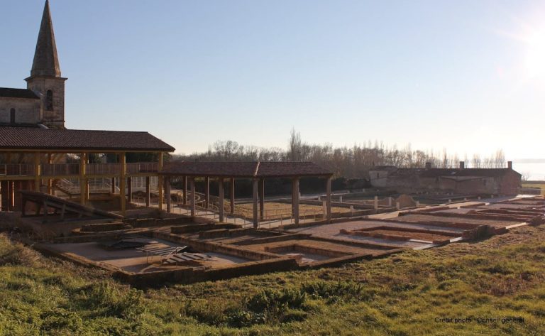
Two long, parallel barrack blocks formerly occupied the interior. Each contained forty rooms, with three or four beds in each room, and corridors opened toward the central courtyard. Their condition deteriorated, and they were dismantled between 1930 and 1950. Stone was sold or reused in construction, leaving remnants principally from the southern block.
The southern barrack block contained the chapel and the chaplain’s apartments at one end. The chapel was reduced to the pillars of its arcades and the lower courses of its walls before its reconstruction with two semicircular arches in 1994.
Bakery and medical arrangements
The northern barrack block housed the bakery, the baker’s room, a flour-storage loft, and rooms for the garrison surgeon. Its two ovens could produce up to 400 daily rations in five batches. Heat from the ovens warmed the room used for sick soldiers. The fort had no dedicated sickroom, so more serious cases were taken by boat to the civil and military hospital at Blaye, which could accommodate up to fifteen patients, or more rarely carried by road to Bordeaux.
Powder Magazine
A separate powder magazine, a fortified storehouse for gunpowder, was built in the south-eastern bastion. Like the corresponding magazine at Blaye, it could hold nearly sixteen tonnes of powder. Its walls were almost one metre thick, with an outer protective wall, a circulation corridor, and a semicircular vault covered with earth. A steep roof, supporting buttresses, ventilation openings, and a wooden floor helped protect the powder from damp. Stores of shot were kept there as well.
Water storage
A water-storage installation was built west of the northern barrack block in 1823. The fort’s two wells produced brackish water because of the Gironde, so the garrison had previously collected water from the village fountain about two kilometres away. The cistern gathered rainwater from the roofs of the northern barracks and the Royal Guardhouse, filtered it through sand, and held up to 60,000 litres.
Nearby sites