Festung Kniepass: A Historic Defensive Installation in Austria


Site at a Glance
- Rating
- 4.5
- Popularity
- Very Low
- Country
- Austria
- Primary era
- Early Modern
- External website
- Open
- Eras represented
- Early Modern
- Civilizations
- Holy Roman Empire
- Site type
- Military
- Remains
- Fort
On this page12 sections
History
Festung Kniepass is a historic military defensive installation in Austria, near Unken in the municipality of Unken. The pass area preserves traces of Bronze Age settlement, and finds from the ninth and tenth centuries indicate that a defensive installation may have existed here during the early medieval period. The barrier was recorded under the name “Chniepoz” in 1350.
The Route and the Salzburg Archbishops
The route through the pass was altered in 1614 because the Saalach repeatedly flooded the road that crossed a bridge-like terrace near the Rosskogel slope. Under Markus Sittikus, Archbishop and Prince of Salzburg, the road was moved to higher ground and cut through the rock. The work followed plans by Santino Solari, a court-appointed master builder associated with major projects in Salzburg. An inscription connected with the road construction remains in place.
The pass also had a representational role when Salzburg’s archbishops travelled through the area. Fifty armed local militiamen were required to assemble for parade on wooden banquettes along an elliptical ravelin, an outwork positioned in front of a fortification to strengthen its defence. The banquettes decayed and were removed in 1747 on the orders of Artillery Lieutenant Geyer.
Military Use and Decline
In 1707, the provincial estates proposed abolishing surplus fortifications across the country. Archbishop Johann Ernst Thun opposed the measure, and the Kniepass could again be occupied by riflemen during the wars of 1742 to 1745. The Court War Council, the central military authority of the Habsburg monarchy, later ended the pass’s military function. The provincial estates transferred the installation to the Court Chamber, a central institution responsible for state property and revenues, in return for the assumption of maintenance costs.
A hunter and forest supervisor from Unken lived in the building from 1766 to 1794. The provincial estates later tried to sell the remnant of the earlier military conflicts, but Archbishop Hieronymus Colloredo prevented the sale. The installation was therefore available for territorial defence again during the French Wars, the European conflicts of the Revolutionary and Napoleonic period.
After the Stein Pass could no longer be held in 1805, Field Marshal Count St. Julien withdrew behind the Kniepass. On 25 September 1809, an attack led by Josef Speckbacher against Bavarian forces commanded by General Rechberg achieved initial successes before ending in the defeat of the Salzburg defenders. Speckbacher was a Tyrolean military leader associated with the 1809 uprising against Bavarian and Napoleonic rule. The fortress lost its military function after these events.
Domestic Occupation and Preservation
Families lived in the old buildings again from 1830. The last residents were Johann and Genoveva Pletzer, who remained there until 1965. Genoveva died in 1969, while Johann moved to a retirement home in Leogang and died there in 1971.
In the final days of April and the first days of May 1945, tank barriers were built on the road below the fortress. They were intended to obstruct the US Army’s 101st Airborne Division, which was already positioned in Bavaria. The barriers were never used because Army Group South of the German Wehrmacht, commanded by Field Marshal Albert Kesselring, surrendered beforehand.
Salzburg Province has owned Festung Kniepass since 1981 and later undertook extensive repairs with assistance from the Unken Museum Association. Parts of the complex now contain a local-history museum devoted to the fortress and to prehistoric and early historical finds from the Saalach Valley. Temporary exhibitions have been presented there since 1994. Renovation began on 18 October 2023.
Remains
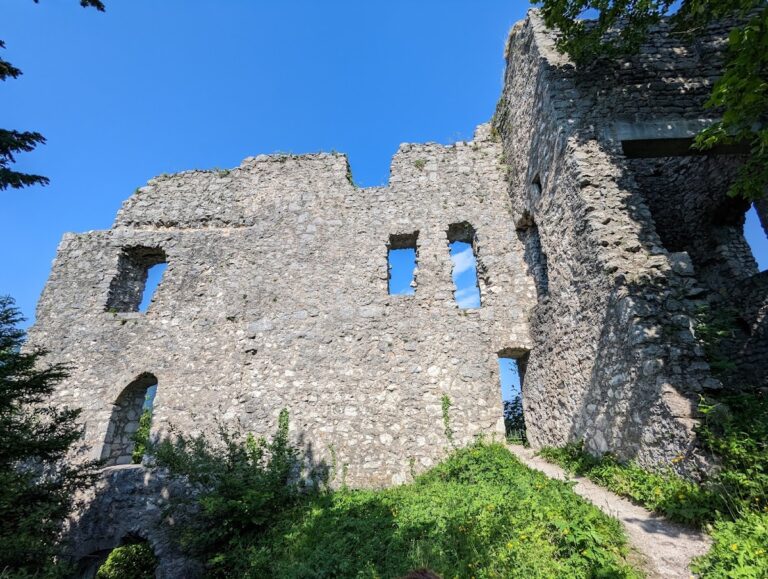
Festung Kniepass lies below the Pfannhauswand and is enclosed by a wall about 2.5 metres high. The defensive complex is entered through the former eastern sally port, a controlled opening through which defenders could leave a fortification, and the gate building. The surviving structures combine military features with evidence of later domestic occupation and museum use.
Defensive Buildings and Courtyard
Wall, Sally Port, and Gate Building
The enclosing wall defines the defensive complex, while the former eastern sally port provides its historic entrance. The gate building now contains the museum reception and a small kitchen. During the Pletzers’ occupation, it also served as a stable for two goats, linking the building’s military past with its later domestic use.
Blockhouse
The large blockhouse includes a ground-level section with a shingle roof, a smoke kitchen, and a principal tract. Beneath the steep roof, a sentry walkway formerly ran around the building. Loopholes on all four sides were directed toward the four cardinal directions. The room now identified as the smoke kitchen was used as a storeroom by the Pletzer family, while the barracks building provided their living quarters.
Cistern and Water Supply
A cistern constructed in 1673 formed part of the fortress’s water system. It had ceased operating by about 1800. During the Pletzers’ residence, water was carried from a small spring near the Pfannhaus wall and, during prolonged dry periods, from the Saalach. Only one room could be heated, and daylight entered through small windows. The buildings also preserve evidence of a household supplied without electric lighting or running water.
Ravelin and Courtyard Stage
An elliptical ravelin formerly carried the wooden parade banquettes used by the armed local militia. After the structures decayed, they were removed in 1747. The lower part of the inner courtyard now contains a stage used for concerts and performances.
Archaeological Collections
The museum presents prehistoric and early historical material from sites in the lower Saalach Valley. Its displays include Late Paleolithic stone flakes dated to about 10,000 BC, together with artefacts from the Copper Age, Bronze Age, Hallstatt period, and Roman period. A permanent exhibition focuses on rock engravings from the lower Saalach Valley.
Rock-Cut Road
Near the Rosskogel slope, the 1614 road diversion was cut into the rock above the flood-prone route along the Saalach. Its surviving construction inscription states that Markus Sittikus opened the road through extremely hard rock for the lasting security and public benefit of the route. The inscription preserves the connection between the fortress area, the pass route, and the archbishop’s road-building programme.