Castle Plaue: A Baroque Residence and Medieval Frontier Stronghold
Site at a Glance
- Popularity
- Medium
- Country
- Germany
- Primary era
- Early Modern
- Eras represented
- Early Modern, Modern
- Civilizations
- German, Holy Roman Empire, Kingdom of Prussia
- Site type
- Domestic
- Remains
- Castle
On this page18 sections
History
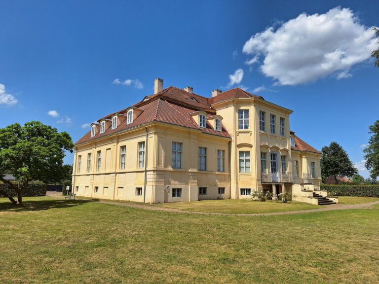
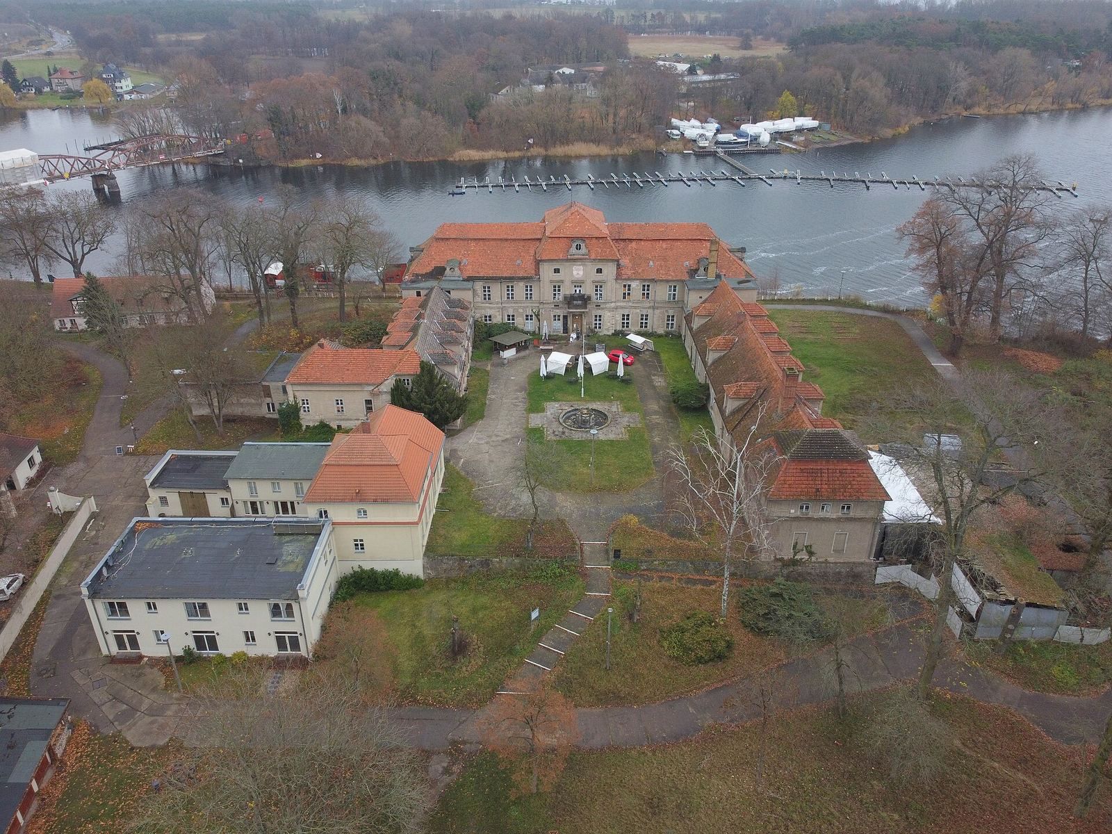
Castle Plaue is a Baroque residence on the west bank of the Havel in Germany, built for Prussian minister Friedrich von Görne between 1711 and either 1715 or 1716 on the site of an earlier stronghold. Its medieval predecessor guarded an important river crossing and trade route during centuries of rivalry between Brandenburg and Magdeburg.
Medieval frontier
A Slavic fortified earthwork probably stood at the site before the medieval castle. Plaue’s position beside a ferry crossing on the Havel made it strategically valuable, as did a trade route that later became Bundesstraße 1. From the 12th through the 15th century, the area was contested between the secular Margraviate of Brandenburg and the Prince-Archbishopric of Magdeburg, the archbishop’s separate secular territory.
The name Plaue was recorded in 1197 for a family associated with the castle, while the settlement itself appears in records in 1216. Family members served as retainers to the Archbishop of Magdeburg or the Bishop of Brandenburg, holding land or office in return for service. The settlement stood on the boundary between the Bishopric of Brandenburg and the Archbishopric of Magdeburg, church jurisdictions that were distinct from the two secular territories.
Before 1268, Plaue and its castle belonged to the Margrave of Brandenburg. After the Ascanian dynasty that ruled Brandenburg died out, they apparently passed to the Prince-Archbishopric of Magdeburg. In 1294 the castle was named castrum Plaue, or Castle Plaue. From 1334, the castle and rights to safe passage and customs collection were pledged to different holders, with some agreements requiring repairs or improvements. Magdeburg’s early registers describe the castle as a base for archiepiscopal retainers and landholders with fiefs, or holdings granted under a bond of service, in nearby villages.
Conflict and changing control
Brandenburg’s margraves built a rival castle on the Havel’s eastern bank, recorded in 1336 as Niederhus. During prolonged disputes and wars between Brandenburg and Magdeburg in the late 14th century, the holders of Plaue became relatively independent. Lippold von Bredow, governor of the Middle March, was among them. His daughter Agnes married Johann von Quitzow, who gained control of the castle. Johann and his brother Dietrich used their position at Plaue to raid lands belonging to both Brandenburg and Magdeburg.
In 1414, Margrave Friedrich I and his Magdeburg ally took the castle after a siege and expelled the Quitzows. Arbitration settled the dispute between Brandenburg and Magdeburg in 1421, when Archbishop Günther II renounced his claim to Plaue. Archbishop Friedrich III formally gave it up in 1449 under the Treaty of Zinna.
In 1459, the elector’s chamberlain Georg von Waldenfels received Plaue as a pledge on condition that he replace the ferry with a bridge. The bridge was completed in 1463. A hereditary grant in 1469 required him to renew the castle’s defences. A chapel with an altar dedicated to Saint Anne, the mother of Mary in Christian tradition, is first noted in the early 16th century.
Early modern ownership and rebuilding
Elector Joachim I, a prince entitled to take part in choosing the Holy Roman Emperor, took Plaue into his personal possession in 1531. In 1544, the castle was transferred to Franz von Dornstätt through a redemption arrangement. Matthias von Saldern advanced money to the elector and received the castle as a pledge, although in 1547 it was assigned as the private property of Sabina of Brandenburg-Ansbach, wife of the future elector Johann Georg. In 1560, Joachim II exchanged Matthias’s pledge for Plattenburg. Johann Georg sold Plaue to the von Arnim family in 1577.
The castle and the small town were destroyed during the Thirty Years’ War, a major European conflict fought from 1618 to 1648. The von Görne family had owned the property since 1620. Friedrich von Görne commissioned a new Baroque castle, largely in the form that survives today. His son Leopold inherited it in 1745 and enlarged the park in 1755. From 1765 to 1793, Prussian general Heinrich Wilhelm von Anhalt owned the estate and had many structures in Plaue dismantled. The property then passed to Adolf Julius Lauer von Münchhofen and his wife, Marie Magdalene Charlotte von Stoltzenberg. In 1839 it came into the ownership of the counts of Königsmarck, who retained it until its expropriation in 1945.
Park, industry, and modern use
The von Königsmarck family reshaped the grounds as a landscape park around 1850, and the park has been open to the public since 1935. A brickworks south of the park operated from at least 1842 to 1914, first under Ferdinand Michaelis of Rathenow and later under a count of Königsmarck. After the brickworks closed, a nursery and gardening business used the site until the early 1990s. From about 1890, the brickworks buildings also accommodated park operations, including a coach house.
At the end of the Second World War, the Red Army plundered the castle. After its expropriation, the building briefly served as a rest home for Soviet children and as a military hospital. An administrative school occupied it from 1946 to 1966. Repairs in 1965–1966 simplified the facade, and a language-training institute and interpreter school run by the GDR Ministry of Foreign Affairs then moved in. The GDR, or German Democratic Republic, governed East Germany from 1949 to 1990. The castle opened to the public in 1989; the institute closed in 1993, and the property passed to the State of Brandenburg.
Remains
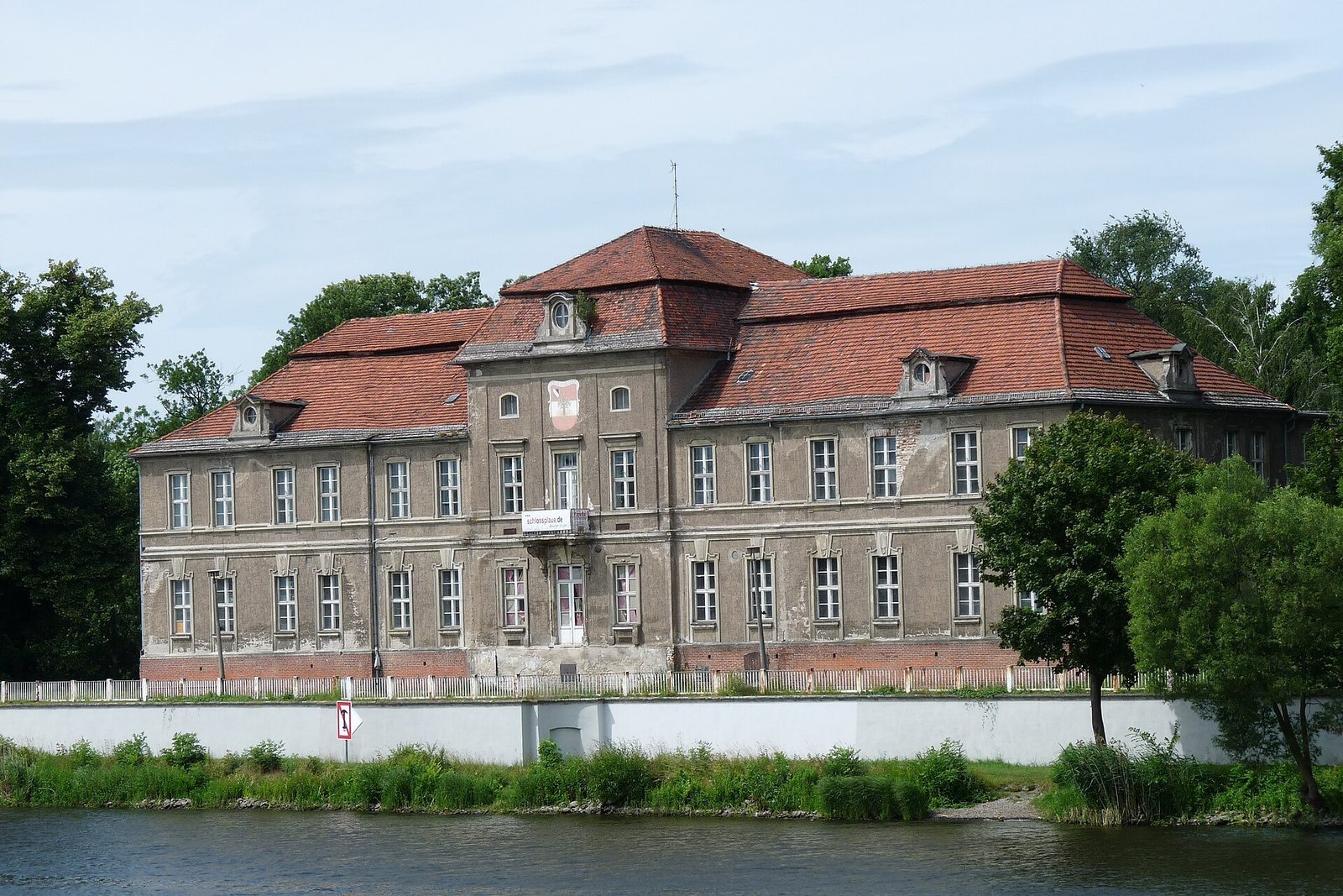
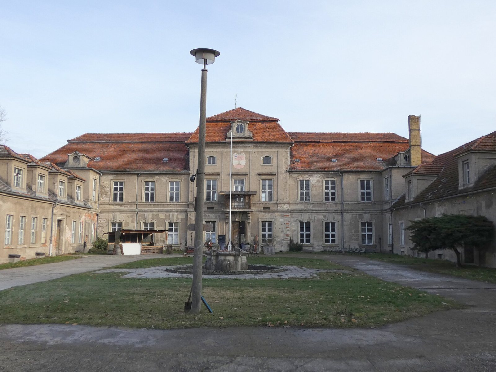
The surviving Baroque complex stands where the Havel flows out of Lake Plaue. Three wings enclose a courtyard: the two-storey principal block lies beside the river, with single-storey wings extending from it. The estate’s surviving features include the castle, parkland, watercourses, garden boundaries, and structures associated with later uses of the grounds.
Castle architecture
Principal block and wings
The river-facing principal block has a central projection rising to a mezzanine, a low intermediate storey. Its mansard roof has a steep lower slope and a shallower upper one, and is covered with red beaver-tail tiles, flat tiles with rounded ends. Curved dormers rise from the roof, and a balcony sits centrally on the upper storey on both the courtyard and river sides. A two-flight exterior staircase on the river front survives in largely dismantled form.
The south wing ends in the former chapel, which rises to a mezzanine beneath a mansard roof. The rest of this wing has a gable roof with hipped dormers. The north wing has a half-hipped roof, with its gable ends partly sloped, and dormers. The castle’s gray-rendered facade is divided by cornices and window surrounds, with stucco keystones, wedge-shaped blocks above openings.
Courtyard and north extension
A separate building constructed in 1913 adjoins the north wing across a path and helps enclose the courtyard. It has a mansard roof, and a fountain stands within the court.
Park and associated features
Park setting and water features
The English landscape garden extends south from the castle along the northwestern shore of Lake Plaue toward the Wendsee and the Seegarten Bridge. A pond south of the castle connects with Lake Plaue at two points, crossed by two curved brick bridges built between 1851 and 1880. In the park’s southwest, a pond once used to raise crucian carp has silted up; the lightly maintained area is left wild as a refuge for birds and other animals. A school and sports ground occupy adjoining land that formerly belonged to the park.
Walls and garden remnants
A brick wall in the rectory garden survives from the former boundary wall and dates to the early period of the landscape park, around the mid-19th century. The cemetery wall was built at about the same time. A formal French garden, once used to grow fruit, was enclosed by a wall about two metres high. Fragments of its walls remain on private properties adjoining the park.
Angel Gate
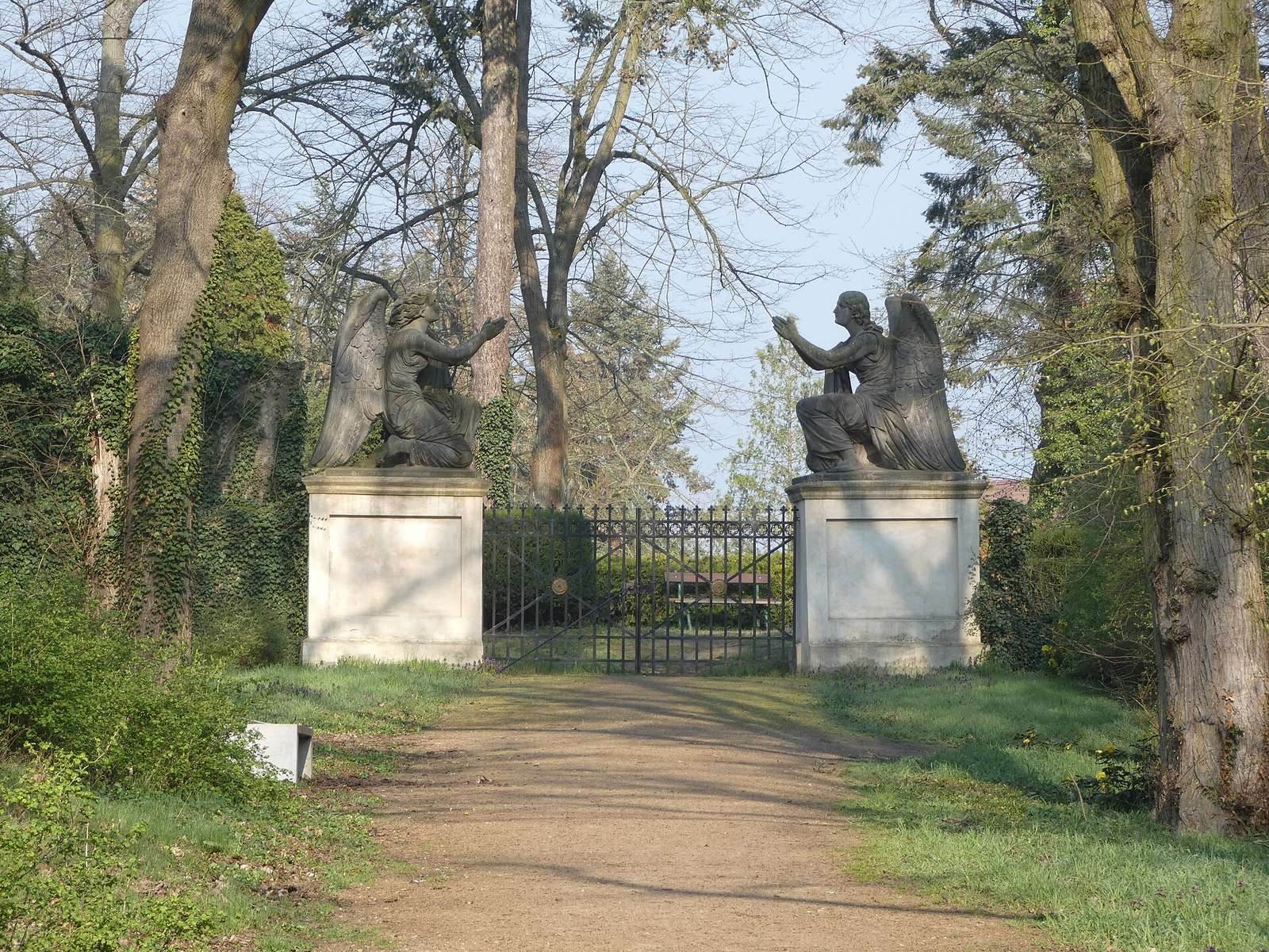
The Angel Gate connects the park with the cemetery of Plaue’s parish church. It provided the count’s family, which held rights of church patronage, a separate route from the castle to the church and cemetery, where the family tombs were located. Two large sandstone angel sculptures on plinths frame the iron gate. A. Möller carved them in 1835 at the request of Baroness Charlotte von Lauer-Münchhofen.
Hunger Tower and landing stage
The ornamental Hunger Tower was designed with sightlines toward the castle and lake. It was dismantled in the 1950s, and its foundations remain. A T-shaped landing stage projects into Lake Plaue. In the mid-1970s it was built up with fill and fitted with a guardhouse and barrier for the GDR customs administration, which used it to monitor inland shipping to and from West Berlin.
Shooting stand and memorials
A clay-pigeon shooting stand built around 1900 by castle owner Hans Adolf Erwein Max, Count von Königsmarck, is reputed to be the world’s oldest surviving example. Larger-than-life animal figures on plinths include a bear and a markhor, recalling a hunting trip to the Himalayas. Trophies were added later, and copies replaced the badly damaged original figures in 2013.
The base of an urn statue marks the place where the counts of Königsmarck buried their dogs. A bronze statue of the writer Theodor Fontane, made by Dirk Harms and installed in 2012, stands at the site of a former horse burial. Fontane wrote about Castle Plaue in his 1889 book Fünf Schlösser, part of Wanderungen durch die Mark Brandenburg.
Brickworks and coach house
The former brickworks site lies immediately south of the park. The coach house occupied one of the brickworks buildings, linking the industrial complex with the estate’s grounds.
Earlier archaeological evidence
Probable Slavic earthwork
Several pottery fragments of Slavic origin, dating from the 9th to the 12th century, came from earthworks at the castle site. The probable earthwork fortification stood directly beside the Havel, about two metres above the surrounding ground, a position characteristic of this type of fortified site.