Bintepe: The Burial Landscape of Ancient Sardis in Turkey
Site at a Glance
- Popularity
- High
- Country
- Turkey
- Primary era
- Iron Age
- Eras represented
- Iron Age, Classical, Modern
- Civilizations
- Achaemenid, Lydian
- Site type
- Burial
- Remains
- Necropolis
On this page15 sections
History
Bintepe is the burial landscape of ancient Sardis in Turkey, about 6–10 km north of the city. The Lydian cemetery served kings and elite families, and later other high-status groups, chiefly from the seventh through fourth centuries BC. A tumulus is a burial mound, usually covering a grave or burial chamber. Lydia was an ancient kingdom in western Anatolia, and Sardis was its capital.
Before the Lydian cemetery
Evidence of human activity across the Bintepe landscape reaches back to the Middle and Upper Paleolithic, or Old Stone Age, and includes Late Chalcolithic and Bronze Age sites. Surveys in central Lydia identified a Late Chalcolithic settlement and at least nine Early Bronze Age sites, most in the Bintepe hills. Their pottery points to dispersed production and little difference in settlement scale or status.
During the Middle Bronze Age, many communities left lowland sites for more defensible locations. At least four of the thirteen known sites from this period occupied fortified ridges or hills. The Bronze Age citadel of Kaymakçı and other fortified settlements around Marmara Lake form part of this regional history. At least six citadels have been identified around the lake, but they were not occupied again after the Bronze Age collapse. Later Lydian mounds were built near some earlier settlements, but not within the citadel ruins. This pattern may reflect respect for ancestral places, while the cemetery has also been interpreted as linking Lydian elites to the region’s earlier past. Continuity in Bronze Age religious practice remains uncertain.
Lydian and Persian-period burials
The earliest mounds date to about 600 BC. Their form may have drawn on Phrygian royal burial traditions, especially the large tomb mounds near Gordion in central Anatolia. From the first half of the sixth century BC, chamber tombs beneath substantial mounds became a prominent burial form among wealthy Lydian landowners and people with close connections to Sardis.
The cemetery’s location may have carried meaning beyond practical burial needs. Lydian kings may have associated themselves with local heroes, ancestral memories, and sacred aspects of the landscape. The conspicuous mounds could also express royal authority and elite wealth. Some clusters may have represented families or estates. Rural settlements nearby may have supplied food, labor, and building materials to Sardis and the tombs.
When Cyrus II conquered Lydia around 547–546 BC, the kingdom came under Achaemenid rule. The Achaemenid Empire was the Persian empire founded by Cyrus. Bintepe’s cemetery then served a wider circle of wealthy or high-status people, rather than only royal burials. Many datable mounds belong to the Persian period, and some may have been built within two or three generations of the death of Alyattes, a Lydian king and father of Croesus. As Persian cultural influence increased, mound building declined in central and greater Lydia, although the mounds remained associated with elite burials into the Hellenistic era, which followed Alexander the Great’s conquests, and the Roman period.
Later use and the changing landscape
Water levels and periodic flooding around Marmara Lake and the Gediz and Alaşehir river valleys shaped the wider area. Sediment research indicates substantial drying near the end of the Roman period, possibly during drought. In modern times, Marmara Lake dried out in 1994 and neared a zero water level in 2007 and 2008. Repeated flooding and drying may have contributed to sacred associations with the water and land. During the Roman imperial period, sanctuaries in the Bintepe and lake region were dedicated to Zeus Driktes, Apollo Pleurenos, and the Lydian Mother of the Gods, associated with Artemis Gygaia or Artemis Coloë.
During conflicts between Greek and Persian forces, some Lydian mounds were reused as lookout points. From the seventeenth through nineteenth centuries, Turkmen groups camped among the Bintepe mounds and engaged in banditry against travelers. In 1919, the Milne Line, separating Greek-held territory to the west from Turkish-held territory to the east, crossed the hills. Military positions and trenches were also constructed among the mounds during the Turkish War of Independence.
Investigation, damage, and protection
Tombs were robbed in antiquity, and treasure seeking continued in later centuries. Their cultural importance had largely faded from local memory by the early twentieth century. Looting intensified from the middle of that century, while farming and other development also destroyed mounds. Comparison of aerial photographs from 1994–1995 with satellite imagery from 2006 indicates that at least fifteen of an estimated 130 ancient mounds were levelled, most between 1994 and 2006.
The first documented excavations were carried out in the 1850s by Ludwig Spiegelthal, the Prussian consul in Smyrna. His work included the mound attributed to Alyattes and contributed to a published map of the landscape in 1858. George Dennis and Auguste Choisy excavated further mounds in the 1870s and 1880s. Howard Crosby Butler’s Sardis expedition investigated four in 1910–1914. A later Sardis expedition, initially led by George M. A. Hanfmann, excavated and cleared about twenty mounds in 1962–1966. The Manisa Museum carried out additional work from the 1980s to 1998, alongside surveys, geophysical investigation, and historical and inscription studies.
Early estimates of the number of mounds varied considerably. Nineteenth-century counts ranged from more than sixty to about 127–130; Butler counted 72 from the Sardis acropolis but considered the total greater than 100. The Central Lydia Archaeological Survey began work in the Marmara Lake basin in 2005 to investigate ancient use of the landscape and Bintepe’s connections with Sardis and other Lydian cemeteries. Roughly one-fifth of Lydian mounds are placed in central Lydia, while more than 500 have been identified elsewhere in greater Lydia. In 2025, Bintepe was included with Sardis in the UNESCO World Heritage property “Sardis and the Lydian Tumuli of Bin Tepe.”
Remains
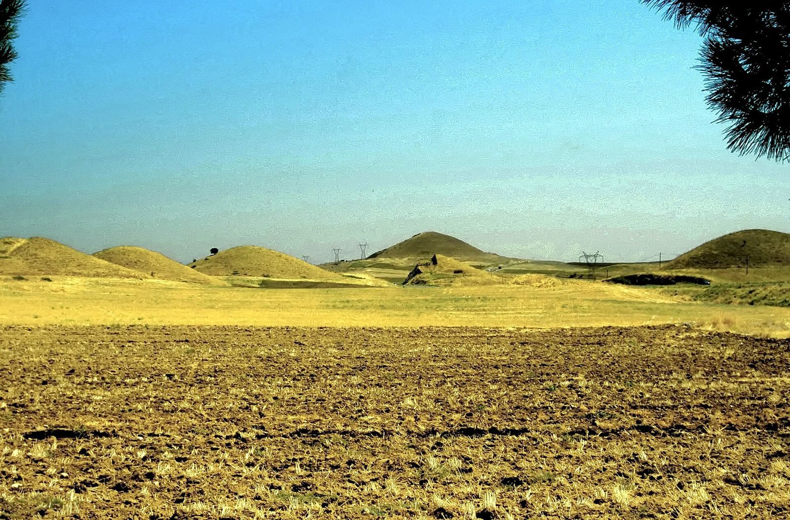
Bintepe occupies a low limestone ridge between the Gediz plain and Marmara Lake. The ridge extends about 15 km, while the burial landscape covers roughly 75 km² and is about 10 km wide. Mounds follow its central crest and raised spurs, as well as the western and northern edges of the lake basin. Many stand on high points with views across the lake, the plain, Sardis, and surrounding mountain ranges.
The ridge and mound forms
Distribution and scale
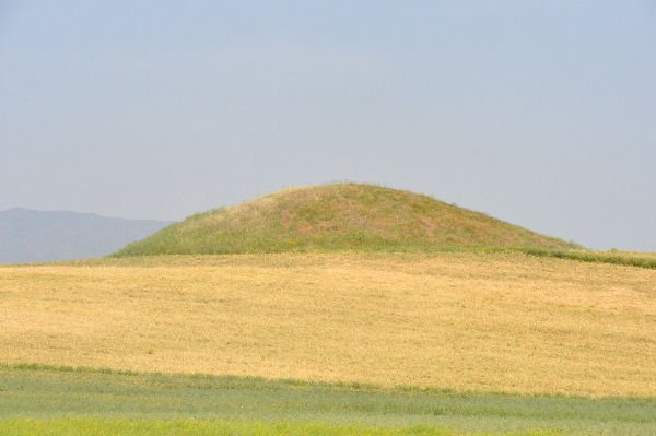
About 115–120 mounds remain identifiable, against an estimated ancient total of at least 130. They range from small examples roughly 10 m across to the largest, which measure several hundred metres in diameter. Some occur in groups near settlements identified by Lydian surface finds; others are more isolated. The three largest command broad views toward Marmara Lake and Göl Dağı to the north, the Gediz plain, Sardis and the Tmolos range to the south, and Çal Dağı and Gür Dağı to the west.
Burial construction
A typical mound covers a stone burial chamber. Builders either assembled chambers from stone slabs or cut them into bedrock, sometimes placing them away from the mound’s centre, possibly to deter robbers. A stone retaining wall could mark the mound’s edge and hold its fill in place. Burial arrangements range from simple pits cut into bedrock to chamber groups with benches for successive burials.
The three largest mounds
Kocamutaf Tepe
Kocamutaf Tepe, generally identified as the tomb of Alyattes, is the largest mound at Bintepe. It measures about 350 m across at its base and stands roughly 60–70 m high, with an estimated volume of 785,000 m³. One estimate places its construction at two and a half years of work by about 2,400 people and 600 draft animals. A stone retaining wall was described on its southern side, though it has not been remeasured since Spiegelthal’s excavations.
The burial chamber lies about 30 m southwest of the mound’s centre and was built from marble blocks. Marble lines the chamber, whose roof consists of five large limestone slabs, each said to weigh about 16 tonnes. A thick charcoal layer above the roof may have helped keep water from seeping through. An inner courtyard leading to the chamber was enclosed by limestone blocks weighing about 12 tonnes apiece. The tomb was robbed in antiquity. Finds include pottery fragments and vessels identified as an alabastron, a small container for perfumed oil, and a lydion, a type of Lydian ceramic vessel.
The fifth-century-BC historian Herodotus described five inscribed stone markers at the summit, naming groups credited with work on the mound. One uninscribed stone monument stands there today. The identification of Kocamutaf Tepe as Alyattes’ tomb is widely accepted but not certain; the mound is generally dated to about 580–560 BC.
Karnıyarık Tepe
Karnıyarık Tepe measures about 220–230 m across at its base and 50–53 m high. Pottery from investigations points to the seventh or early sixth century BC, while construction is generally placed in the sixth century. The mound has traditionally been identified as the tomb of Gyges, founder of the Mermnad dynasty, but both its occupant and dating remain uncertain. It has also been proposed that the mound was enlarged for Atys, a son of Croesus, or for a royal woman.
About 65 m inside the mound’s edge, investigators encountered an unfinished, two-tier limestone retaining wall with a semicircular upper course. It appears to belong to an earlier mound about 85 m in diameter, which was later enlarged and covered. Little of the retaining wall associated with the larger mound survives. The mound was looted in antiquity, and excavations recovered pottery fragments. Investigations have included geophysical surveys, core drilling, and tunnels opened in 1964–1966 and again in 2012, with further studies in 1992, 1995, and 2011.
Marks on the wall include paired shapes resembling the archaic Greek letter digamma, swastika motifs, and signs like alpha and theta. Most interpretations treat them as marks made by builders or masons. Hanfmann suggested that the paired digammas represented Gyges under an Assyrian name, a reading that remains disputed. Other proposals interpret them as a Lydian word for lion or as protective signs.
Kırmutaf Tepe
Kırmutaf Tepe, the third major mound, is reported to be about 300 m across and 53 m high. It has received little investigation, and its occupant has not been identified.
Excavated chamber complex
Tumulus BT05.026, investigated in 2023, is about 50 m in diameter and 8 m high. The looted mound contains two central burial chambers, a vestibule, and an entrance facing south. Some chamber sections were cut into bedrock; others were built from large limestone blocks. The unfinished vestibule exposes stages of stoneworking, while the chambers have smoothed walls. One has a single burial bench; the other has two, one cut into bedrock and one partly carved and partly built. Large stone slabs form the flat ceilings, including a single block of about nine tonnes above the second chamber. Pottery dates from the sixth century BC to the Hellenistic period, indicating use over at least four centuries.
Military remains
Trenches and remains of military positions survive at least ten mounds and two elevated locations in the Bintepe hills. They relate to the 1919 Milne Line and military activity during the Turkish War of Independence.