Arabat Fortress: A Crimean-Ottoman Stronghold on the Arabat Spit
Site at a Glance
- Rating
- 3.5
- Popularity
- Very Low
- Country
- Russia
- Primary era
- Early Modern
- Eras represented
- Early Modern
- Civilizations
- Crimean Khanate, Ottoman
- Site type
- Military
- Remains
- Fort
On this page12 sections
History
Arabat Fortress is a Crimean-Ottoman stronghold in Russia, built by the Ottoman military on the southern end of the Arabat Spit in the seventeenth century. It stood about 2 kilometres northwest of Ak-Monay, now Kamenske, and formed part of a defensive system that also included Perekop Fortress and Yeni-Kale. Together, these strongholds were intended to protect Crimea from attacks approaching from the north and east.
Earlier fortifications and Ottoman foundations
An earlier fortification is associated with the site during the era of the Bosporan Kingdom, an ancient state centred on the Cimmerian Bosporus and its surrounding coasts from the fifth century BC to the fourth century AD. The name Arabat appears as “Arbath” on Bernard Wapowski’s 1526 map of Southern Sarmatia. The fortress itself is first explicitly mentioned in Guillaume Le Vasseur de Beauplan’s Description of Ukraine, published in 1651. A map made by Jacob von Sandrart that same year also represented Arabat using Beauplan’s material.
The fortress was probably founded during the second half of the seventeenth century. Although it stood in territory ruled by the Crimean Khanate, a Turkic-Muslim state that governed much of Crimea and nearby steppe lands from the fifteenth to the eighteenth century, Arabat belonged to the Ottoman-controlled Kefe Eyalet. This was an Ottoman province centred on Caffa and including strategic sites on the Crimean coast. Arabat was directly subordinate to the Ottoman sultan.
The Ottoman traveller Evliya Celebi visited Crimea in 1665–1666 and described Arabat as a position intended to block Russian armies, Zaporozhian Cossacks, Poles, and Kalmyks from entering Crimea. He also related a tradition that a fortress or tower was built after Mehmed II Giray defeated Cossacks and Kalmyks who had raided Crimea across the spit. The story accords with Beauplan’s description of repeated Cossack horse raids in the area, but it remains a foundation legend rather than a confirmed account of the fortress’s origin.
Cossack and Russian attacks
Arabat’s remote location and often small garrison limited its military effectiveness. Cossack and Russian forces bypassed the fortress or operated near it in 1647, 1648, 1675, 1678, and 1737. Zaporozhian forces sometimes crossed the Sivash, a shallow system of lagoons and marshy waters adjoining the Sea of Azov, using fords. In 1737 Field Marshal Pyotr Lassi’s Russian army used boats as a bridge. Ivan Sirko also crossed the Sivash away from Arabat and Perekop during his campaigns in Crimea.
Zaporozhian Cossacks commanded by the koshevoi ataman Ivan Zhdan-Rih, the elected military and administrative leader of the Zaporozhian host, captured Arabat by assault in October 1668. Everyone inside was killed. In 1739, Cossacks led by Colonel Onysym Bilyi helped Russian forces seize the fortress by guiding them across the Sivash at low tide.
Arabat fell again in 1771 during a Russian assault commanded by Vasily Dolgorukov. A detachment under Prince Fyodor Shcherbatov crossed the Henichesk Strait on a boat bridge 50 fathoms long, advanced along the spit, and stormed the fortress on 18 June after a forced march. The attackers took six standards, 50 guns, and a Tatar camp protected by earthworks. Shcherbatov was promoted to lieutenant general and received the Order of Saint George, Third Class, for the operation.
Imperial and Crimean War phases
After the Russian Empire annexed Crimea in 1783, Arabat retained a small garrison for a time. The fortress then deteriorated and was abandoned. During the Crimean War of 1853–1856, it was renovated and returned to defensive use.
In spring 1855, the partly ruined fortress was placed in a defensive position to protect communications along the Arabat Spit. Its garrison grew to two battalions, and 17 guns were installed. A hostile squadron of 13 vessels shelled Arabat for three hours but withdrew without success. The garrison also prevented enemy landings on the spit and hindered hostile shipping in the Sea of Azov.
After the war, the garrison was withdrawn and Arabat lost its town status in 1856. The fortress was abandoned again, while nearby inhabitants used its walls as a source of stone. Arabat is now a ruin, protected as a federally designated cultural-heritage monument of Russia and included in Ukraine’s register of immovable cultural monuments. Satellite imagery indicates that military forces have occupied the fortress since Russia’s 2014 annexation of Crimea.
Remains
Arabat occupies the southern end of the sandy Arabat Spit, the landform separating the Sivash from the Sea of Azov. It stood near Tonka Voda, the strait separating the spit from the mainland. Descriptions give the plan as either an irregular polygon or an octagon. Stone walls about 3 metres thick enclosed the position, while a deep ditch strengthened the defences. Part of the ditch may have been earlier than the fortress, and a channel may once have supplied it with seawater. A possible underground connection with the Sea of Azov has also been proposed.
Walls, gates, and artillery defences
Bastions and gates
The enclosure had five bastions, projecting sections designed to provide flanking fire along the walls, together with two entrances known as the Main Gate and the Sea Gate. Several rows of loopholes faced east, north, and west, with openings intended for different kinds of artillery. One description by Pallas counted seven bastions, but this probably included the gate tower and a redan, a smaller angular projection of a defensive line. The fortress is otherwise described as having five bastions.
Approach defences
An earthen rampart and distant batteries strengthened the approaches from the Kerch and Henichesk sides. These outer positions were protected by earth and stone embankments. About 1 kilometre north of the fortress, a stone causeway crossed the spit between the Sea of Azov and the Sivash. It was made with piles driven transversely into the ground, creating a controlled crossing through the narrow landform.
Interior and shoreline installations
Buildings within the enclosure
The fortress contained powder magazines, a mosque, a bathhouse, and an internal exit leading to the ditch. Evliya Celebi described the main structure as a strongly built circular tower or tower-like fortress measuring 150 broad paces. He also mentioned a commandant, 150 soldiers, an armoury, guns positioned in loopholes, iron gates facing Crimea, and a tower with a vaulted roof covered with boards.
Landing and mosque
A small landing or pier served the fortress. Ottoman fleet anchorages extended along the coast from Arabat towards Cape Kazantip during the first half of the eighteenth century, and possibly as early as the seventeenth century. A mid-nineteenth-century nautical guide described surviving ditches, supporting structures, and the domed mosque. The mosque could reportedly be seen from the sea at a distance of about 10 miles and served as a landmark. Piles from the former landing and a well were visible near the shore, although the well water was completely saline.
Construction and surviving ruins
Arabat was built of stone, with material for its construction and later rebuilding taken from the Ak-Monay quarries about 4 kilometres east along the coast. Beauplan described it as a stone castle with a tower on the narrow isthmus between the Liman lagoon and Tonka Voda. He also mentioned a palisade running from one sea to the other and estimated the strait at about 200 paces across, a distance that could be crossed on horseback in calm conditions. The adjacent land supported a herd that the khan was said to have kept at up to 70,000 horses.
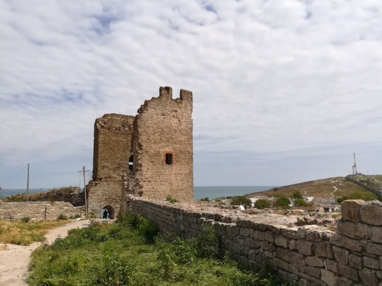
The surviving fortress consists of ruins, including sections of the defensive walls and bastions. These remains preserve the outline of a stronghold shaped by the narrow geography of the Arabat Spit, its position between two bodies of water, and the military routes leading towards Crimea.