Aluston: A Byzantine and Genoese Fortress in Crimea


Site at a Glance
- Rating
- 4
- Popularity
- Very Low
- Country
- Ukraine
- Primary era
- Medieval
- External website
- Open
- Eras represented
- Medieval
- Civilizations
- Byzantine, Genoese
- Site type
- Military
- Remains
- Fort
On this page13 sections
History
Aluston is a Byzantine fortress in Ukraine, located in Alushta on the southern coast of Crimea. Founded in the sixth century under Emperor Justinian I, who ruled the Byzantine Empire from 527 to 565, it served as a coastal stronghold and controlled shipping in the surrounding waters. The fortress is first mentioned by the Byzantine historian Procopius of Caesarea in On Buildings, his account of construction undertaken during Justinian’s reign.
Byzantine foundation and Khazar rule
Procopius described Aluston as a strongly built fort garrisoned by Ostrogoths serving Byzantium as federates, foreign or allied troops who retained a distinct ethnic identity within the imperial military system. The garrison regulated coastal movement and helped maintain order in the surrounding area. Byzantine strategic activity in Crimea also led to the construction of the nearby fortification of Gorzuvity.
Byzantium abandoned Aluston by the end of the seventh century. Its territory then became part of the Khazar Khaganate, a powerful medieval polity whose authority extended into parts of Crimea. The fortress was destroyed in the tenth century, possibly during an attack by the Pechenegs, a nomadic Turkic people active around the Black Sea. After this destruction, the settlement entered a period of decline.
Medieval revival and Genoese possession
Conditions in Crimea stabilized from the twelfth century, allowing Aluston to revive and expand. The settlement developed into a town of craftsmen, fishermen, and merchants, while open settlements nearby supplied agricultural produce. During the eleventh and twelfth centuries, Aluston probably paid tribute to the Cumans, a Turkic-speaking steppe people dominant in the region during that period. From the second half of the thirteenth century, tribute was paid to Tatar powers that had expanded into Crimea.
Around 1380 to 1382, Aluston, known to the Genoese as Lusce, passed into Genoese possession. The acquisition formed part of a wider Genoese coastal territory associated with 17 villages in the Sudak district. Aluston became a trading settlement within the Genoese Captaincy of Gothia, the colonial administration that governed Genoese coastal settlements and fortified positions in Crimea. Its population was estimated at between 1,000 and 1,500 people.
Genoese reconstruction probably began after the transfer of power. By 1422, the fortress was in existence, and the authorities of Caffa, Genoa’s principal Crimean commercial and administrative center, allocated substantial funds to repair its defenses before a possible war with the Principality of Theodoro. This Christian principality was centered on Mangup in southwestern Crimea.
Destruction and later history
In 1474, the owner of Lusce was a vassal of the princes of Mangup and sought their support against the Genoese feudal brothers Guasco. Aluston remained an important port in the late Middle Ages and appeared on numerous maps made during the fifteenth and sixteenth centuries.
In June 1475, the Ottoman attack on Genoese possessions in Crimea reached Aluston. The fortress was assaulted and destroyed, and archaeological evidence connects the settlement’s destruction with a major fire. The fortress was not rebuilt. Small houses were later attached to its ruined walls and towers, and the site remained a village until the beginning of the nineteenth century.
During the nineteenth century, a privately funded effort was made to restore the ruins. Near the end of that century, the patron N. D. Stakheev undertook repairs because the Lower Tower was in danger of collapse. Aluston is recognized as a nationally significant cultural-heritage monument of Ukraine and, under the Russian administration of Crimea, as a cultural-heritage object of federal significance. The archaeological complex received federal designation in October 2015. In 2020, an open-air museum was established within the fortress area, presenting excavated finds and an exhibition devoted to fifteenth-century inventions.
Remains
Aluston stood about 200 metres from the sea on the summit of a hill approximately 44 metres high. The Byzantine fort originally occupied about 0.25 hectares. By the second half of the tenth century, its fortified area had expanded to roughly 0.5 hectares, while the later medieval settlement covered about 3 hectares. The Genoese fortress occupied the hilltop in an irregular quadrilateral measuring approximately 135 by 125 metres, with an inner citadel, the strongest fortified part of a larger fortress, and an outer defensive wall.
Fortifications and defensive towers
Byzantine walls
The Byzantine defenses were built from diorite boulders laid in lime mortar. Their walls stood about 7 to 8 metres high and exceeded 2 metres in thickness. This earlier masonry has survived better than the materials used in later rebuilding, preserving evidence of the fortress’s sixth-century construction and subsequent expansion.
Genoese defensive line
The Genoese walls and towers used rubble masonry bonded with sand-and-lime mortar. Their thickness ranged from about 2 to 2.45 metres. The western defensive line measured approximately 135 metres, the southern line 125 metres, and the northeastern line 150 metres. Towers stood about 75 to 77 metres apart, and the walls enclosed the perimeter. The later defensive system incorporated the towers known as Chatal-Kule, Orta-Kule, and Ashaga-Kule.
Ashaga-Kule
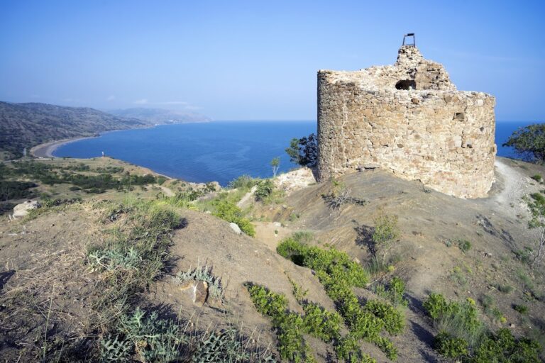
Ashaga-Kule, or Lower Tower, is a cylindrical structure about 10 metres in diameter and 16 metres high. During the Genoese period it rose approximately three metres higher and carried a crenellated top, with raised sections forming the edge of its fighting platform. Defense was conducted from this upper platform. A wooden framework embedded in the masonry helped limit deformation as the mortar dried and absorbed seismic stresses. The tower survives in ruined form.
Orta-Kule
Orta-Kule, or Middle Tower, was square, measuring about 12 by 12 metres and reaching approximately 20 metres in height. It could accommodate around 25 shooters. Its outer face had a talus, a sloping masonry base that strengthened the lower part of the tower and made direct assault more difficult. From the second floor, the rear side was open, a feature also found in other Genoese and Theodorian fortresses of the fourteenth and fifteenth centuries in Crimea.
Chatal-Kule and the northeastern defenses
Chatal-Kule, or Horned Tower, was a hexagonal tower on the northern side of the defenses. Its name probably referred to the crenellations around its fighting platform. The fortress gate was probably located beside it. At the center of the northeastern defensive line stood a rectangular tower measuring approximately 12 by 12.5 metres. It projected 12 metres beyond the wall line, survives to a height of up to 8 metres, and had walls between 2.75 and 2.85 metres thick.
Southeastern tower
A round tower closed the southeastern flank of the defenses. The defensive walls and towers were built in rubble masonry, while the round form of Ashaga-Kule is considered atypical of both Byzantine and Genoese fortification traditions.
Church and medieval settlement
Excavations revealed the remains of a Christian church built during the Byzantine period. The church dates to the eighth century, and an inscription indicates that it was restored in 1404, linking the surviving structure with the later medieval occupation of Aluston.
The medieval town contained two-storey houses arranged in a dense network of urban quarters. Open settlements outside the fortifications formed part of the town’s economic setting and supported it with agricultural production. Together, the fortifications, church, houses, and surrounding settlement preserve the changing form of Aluston from a Byzantine military post into a medieval trading town.