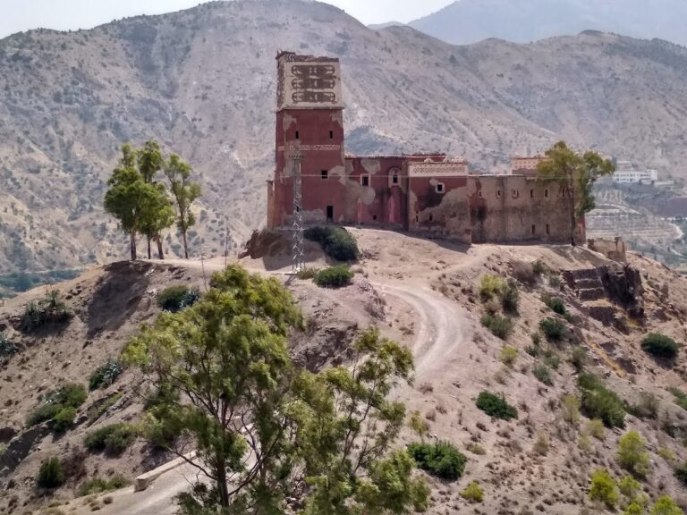
Msoun: A Saadian-Era Military Fortress and Administrative Center in Morocco


Site at a Glance
- Rating
- 4.3
- Popularity
- Very Low
- Country
- Morocco
- Primary era
- Early Modern
- Eras represented
- Early Modern
- Civilizations
- Alaouite
- Site type
- Military
- Remains
- Fort
On this page11 sections
History
Msoun, also known as Kasbah Msoun, is a late seventeenth-century military fortress and administrative center in Morocco, established under Sultan Moulay Ismail of the Alaouite dynasty. Construction dates to 1680, although 1684 is also associated with the site. The kasbah formed part of Moulay Ismail’s effort to extend central authority, control strategically important territory, and secure routes across Morocco.
Foundation under Moulay Ismail
A military structure already stood nearby, probably a medieval fortress associated with the Marinid and Zenatian periods. In 1680, Moulay Ismail ordered a new fortress beside the older one. He settled 100 cavalrymen from the Abid al-Bukhari, a corps used by the Moroccan sultanate as troops of the central government, together with their families and children. Mansur ibn al-Wafi became the kasbah’s governor and was also placed in charge of the fortresses around Taza and the Oued Za.
Msoun served as a base for monitoring the Houara, Beni Ouarain, Ghiata, Mtalssa, and Branes tribes. Their conflicts and attacks on settled communities formed part of the historical condition known as siba, a term for areas or tribal communities outside effective central government control. The kasbah helped maintain regional security while extending the sultan’s authority over the surrounding area.
Administration, taxation, and commerce
The fortress also operated as a tax-collection center. Taxes, charitable levies, and tithes from nearby tribes helped provision the garrison, feed its horses, and support the central treasury. A market within the kasbah enabled local inhabitants and surrounding tribes to exchange goods, giving the military installation an important commercial function as well as an administrative one.
Its location on routes linking eastern and western Morocco allowed Msoun to monitor a broad area. Connections extended toward the eastern Rif to the north and the Middle Atlas to the south. The kasbah therefore combined military surveillance, government administration, taxation, and local commerce in a single fortified settlement.
Resistance and abandonment
During the French Protectorate, local tribes, particularly the Houara, Beni Ouarain, and Ouled al-Hajj, mounted fierce resistance in the region in late May 1911. The French army occupied Msoun in 1913 after artillery bombardment of the area and the destruction of several other kasbahs.
The kasbah was later abandoned. Severe neglect and accelerated deterioration have since affected the site, while restoration and heritage enhancement have been identified as urgent measures to prevent its complete disappearance. Msoun is included among Morocco’s fortifications and is recognized as a cultural-heritage site within Guercif Province.
Remains
Msoun stands near Taddart, between Taza and Guercif, beside and overlooking the Oued Msoun in Morocco’s Oriental region, at an elevation of about 536 metres. The kasbah occupies a position on or beside the slope of the river valley, suited to surveillance and defense. The Oued Msoun extends for approximately 120 kilometres from the Aknoul area in the eastern Rif toward its confluence with the Moulouya River.
Fortifications and garrison
Earthen walls and towers
The kasbah was built chiefly with rammed earth, known in Moroccan architecture as pisé, together with brick. Surviving elements include earthen walls and towers. The walls were thick and pierced by few openings, features consistent with the site’s defensive purpose. Most of the kasbah has collapsed, and the remaining structures continue to deteriorate without restoration or maintenance.
Military barracks
A military barracks housed the 100 Abid al-Bukhari cavalrymen stationed at Msoun, along with their families. This residential arrangement reflected the kasbah’s role as a permanent garrison and administrative base rather than a temporary military position.
Market and religious facilities
Market
A large market occupied part of the kasbah and provided a place for exchanging goods among local inhabitants and neighboring tribes. Its presence connected the fortified settlement’s military and fiscal functions with the commercial life of the surrounding communities.
School and cemetery
The site included a school where Islamic jurisprudence and the Quran were taught. An old cemetery stood beside the kasbah, adding a religious and funerary component to the settlement’s institutional landscape.
The names Msoun and Amsoun derive from a local Amazigh word meaning “salty,” a reference to the saline water of the adjacent river. In the local Amazigh dialect, the river is associated with the expression “salty water.”