Middelgrundsfortet: A Sea Fort in Copenhagen’s Coastal Defenses


Site at a Glance
- Rating
- 4.5
- Popularity
- Very Low
- Country
- Denmark
- Primary era
- Modern
- Eras represented
- Modern
- Civilizations
- Danish
- Site type
- Military
- Remains
- Fort
On this page10 sections
History
Middelgrundsfortet is a sea fort in Denmark, built between 1890 and 1894 as part of Copenhagen’s coastal defenses during the reign of Christian IX. A sea fort is a fortified military installation built in or over coastal waters to control a harbour entrance, channel, or maritime approach. The fort was intended to protect Copenhagen from bombardment by sea after Denmark’s severe military defeat by Germany in 1864.
Coastal defense and military service
Middelgrundsfortet and nearby Fort Charlottenlund were designed to close the Hollænderdybet channel, a favorable route for an attack on Copenhagen and the fortifications on Amager. Fort Charlottenlund, north of Copenhagen, supported Middelgrundsfortet from the west. Together with Trekroner Fort and Flakfortet, Middelgrundsfortet formed one of three artificial islands created to defend the entrance to Copenhagen Harbour.
From 1895 to 1932, the fort belonged to the Danish Army and operated as a battery. From 1932 to 1965, it was administered by the Royal Danish Navy, which used it as a mine station. A mine station supported the deployment or maintenance of sea mines intended to obstruct shipping routes. During the Cold War, the Royal Danish Air Force administered the island from 1965 to 1984, and a HAWK surface-to-air missile system was installed there in 1968.
The German invasion and later military transition
On 9 April 1940, during Germany’s invasion of Denmark, the minelayer Hanzestad Danzig entered Copenhagen Harbour with the icebreaker Stettin and two patrol boats. Middelgrundsfortet guarded the harbour, but its newly appointed Danish commander hesitated to act, allowing the vessels to pass the fort unhindered.
The military abandoned the island in 1984, after which it was transferred back to the navy. From 1984 to 1985, it housed a reception and accommodation center for refugees. The island opened to the public in 1988 and passed in 1992 to the Danish Ministry of Defence’s Fortifications and Nature Secretariat. In 1998, ownership moved to the state property agency Freja Properties A/S, and in 2002 the island was sold to private investors.
Private ownership and Ungdomsøen
During its period of private ownership, Middelgrundsfortet hosted various events and contained a hotel and restaurant. The hotel was described as having 200 rooms connected by approximately 2 miles of corridors.
In 2015, the island was purchased for 20 million Danish kroner with support from the A. P. Møller and Nordea foundations. Ownership passed to Middelgrundsfonden, which is closely associated with the Danish scouting movement, including Det Danske Spejderkorps and KFUM-spejderne, two Danish Scout organizations.
Renovation from 2016 to 2019 established Ungdomsøen, or “Youth Island,” as a camp and educational center for children and young people. The facility opened on 24 August 2019, with its patron, Princess Benedikte, attending the opening. It was intended for young people generally, not only for Scouts. The fort was registered as an architectural monument in 1984 and received historical-monument status in 1994. The renovation project received a special Renoverprisen award in 2020.
Remains
Island setting and defensive construction
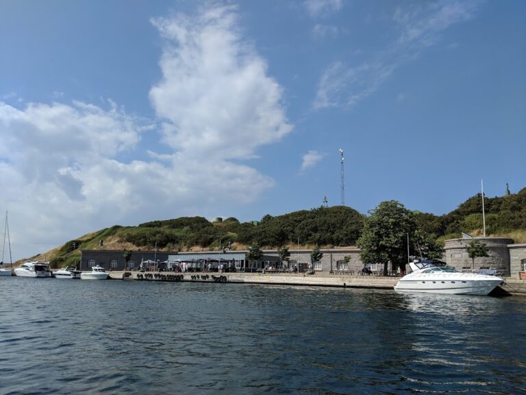
Middelgrundsfortet occupies an artificial island in the Øresund, the strait separating Denmark and Sweden, between Copenhagen and Malmö. It lies approximately 4 to 5 kilometres northeast of the entrance to Copenhagen Harbour, opposite Hellerup and about 1.5 kilometres from Nordhavn Harbour. The island stands between Amager and Saltholm at the northern meeting point of the Kongedybet and Hollænderdybet channels, where the seabed is about 7 metres below the water surface.
The Middelgrund shoal extends for approximately 3 nautical miles. Kongedybet lies to the west and Hollænderdybet to the east, while south of the shoal they merge into the Drogden passage. Flinterenden runs east of Saltholm, and these channels reconnect with the Øresund through Drogden near Dragør.
Stone and sand deposited on the shoal created the island, using material excavated from Frihavnen. The island covers approximately 5 hectares, or about 50,000 square metres. Including the breakwater and small harbour, its area is approximately 7 hectares, or 70,000 square metres. It is about 0.3 kilometres long and 0.1 kilometres wide. At the time of construction, it was described as the world’s largest artificial island and the world’s largest sea fort. It remains described as the largest man-made island without an abutment.
Breakwater and harbour
A stone breakwater surrounds the island. This protective barrier reduces wave action and also prevents a landing. A small harbour occupies the southern rear of the fort and was formerly used by torpedo boats and submarines. Two lighthouses stand on the island.
Barracks and underground spaces
The rear section contains a large, two-storey barracks faced with granite. Underground structures extend across approximately 16,500 square metres and include 30 rooms and tunnels arranged on three levels. The island contains approximately 2.5 kilometres of roads and has an estimated mass of 2.5 million tonnes.
The military installation included bombproof troop quarters, magazines, ammunition-storage areas, and open gun emplacements. At the time of construction, its armament comprised five heavy guns of approximately 30 centimetres calibre, twelve medium guns of 17 centimetres calibre, and thirteen quick-firing guns. An observation cupola for the commander stood at the center of the fort, 25 metres above the island, allowing observation of an enemy and direction of the guns. Electricity supplied lighting, lifts, and ventilation in the buildings.
Renovated facilities
The renovated complex includes a dormitory for 150 people, a kitchen and dining hall for 200, and toilets and bathrooms capable of serving 800 guests simultaneously. It also contains conference rooms for 25 to 250 people, a 40-person laboratory for culinary workshops, activity rooms, camping and tent space for 700 people, and shelter accommodation for 60 people.
Renovation added underwater water-supply and sewage networks. A heat-exchange plant uses energy from seawater for heating, while heat pumps serve the freestanding buildings.
Middelgrunden offshore wind farm
The island is associated with the Middelgrunden offshore wind farm, built on the Middelgrund shoal beginning in 2000. The farm comprises 20 Bonus Energy wind turbines, each rated at 2 megawatts, for a total installed capacity of 40 megawatts. Copenhagen Energy owns ten turbines, while the Middelgrunden Windmill Cooperative owns the other ten through 40,500 shares.
The project began in 1996 through the Copenhagen municipal Office for Energy and Environmental Affairs. Copenhagen Energy and the Middelgrunden Windmill Cooperative developed it jointly. The cooperative has more than 8,000 members and was described as the world’s largest wind-energy cooperative. Each share corresponds to the production cost of 1,000 kilowatt-hours per year and was sold for 4,250 Danish kroner.