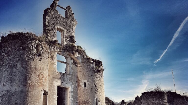
Site Archéologique de Cherré: A Gallo-Roman Religious and Commercial Complex in France

Site at a Glance
- Rating
- 4.3
- Popularity
- Very Low
- Country
- France
- Primary era
- Classical
- External website
- Open
- Eras represented
- Classical
- Civilizations
- Roman
- Site type
- Religious
- Remains
- Temple
On this page16 sections
History
The Site Archéologique de Cherré is an ancient archaeological complex at Aubigné-Racan in France, built and developed by communities of Gaul and the Roman world from the Iron Age into the Gallo-Roman period. It stands on the right bank of the Loir, near routes linking Tours, Le Mans, and Poitiers, in a region where the territories of the Andecavi, Aulerci Cenomani, and Turones met. The Loir was navigable in antiquity, giving the location both religious and commercial importance.
Bronze Age and Iron Age origins
Cherré began as a funerary and cultic complex during the Bronze Age and Hallstatt period, an early Iron Age culture of central and western Europe. Its use continued into the La Tène period, the later Iron Age tradition associated especially with Celtic-speaking regions. The necropolis was probably connected with the fortified Vaux promontory, which had been occupied from at least the seventh century BCE. The position of the later complex appears to have been selected deliberately to continue the area’s funerary and religious role.
From the beginning of the La Tène period, Cherré functioned as a place of warrior cult. Between the end of La Tène B2 and the La Tène D period, weapons, animal remains, ceramics, and metal vessels were deposited in ritual contexts. Further deposits between the D 305 road and the great temple belonged to ceremonies of the third century BCE and seem to have been used for relatively short periods. The site also developed an important commercial role in the Loir valley. By the end of La Tène B2 and during La Tène C1, it formed part of the territory of the Aulerci Cenomani.
The Gallo-Roman complex
Roman conquest increased the importance of the site’s position in the valley. A monumental complex began to take shape toward the end of the first century CE and expanded during the second and third centuries. At its height, it covered more than forty hectares and contained a theatre, a market building, a major temple, a second temple, baths, an aqueduct, and other structures.
Cherré was probably a secondary agglomeration whose principal functions were religious rather than residential. It may have served the imperial cult, the worship of a warrior deity, or both, and may have attracted seasonal commercial and religious gatherings. Its precise institutional character has been interpreted in several ways, including as a vicus, a small Roman settlement unit, a conciliabulum, or place of assembly, a rural sanctuary, and a broader secondary agglomeration. The classification adopted since 1995 remained open to revision in 2016.
Political and administrative development accelerated during the Flavian period, when Domitian ruled the Roman Empire from 81 to 96 CE. Construction and enlargement of the principal monuments generally took place between the second half of the first century and the second century. Intensive use continued until the end of the third century. The great temple was probably begun during Domitian’s reign, while its enclosing precinct and basin belonged to the second quarter of the second century.
Abandonment and medieval reuse
The complex was abandoned between the end of the third century and the beginning of the fourth. Insecurity, economic and political crisis, and the emergence of Christianity may all have contributed to the decline. Use of the ancient complex ceased during the fourth century.
During the early Middle Ages, the area regained a funerary function. A small cemetery, probably Merovingian or Carolingian, contained 39 burials, while a northern cemetery may have held 34 sandstone sarcophagi. Another burial, possibly from the same period, lay near the baths. A small Christian sanctuary may have been associated with the cemetery. Medieval gatherings shifted to Vaas, whose road connections were more favorable. Stone from the ruined monuments was then quarried for nearby buildings, including the Romanesque churches of Aubigné-Racan, Coulongé, Sarcé, and Verneil-le-Chétif, as well as the former abbey church of Vaas. The land eventually returned to agricultural use until the nineteenth century.
Rediscovery and archaeological investigation
The ruins were known by the early eighteenth century. A map of 1706 called them the Château de Gane, a name that local tradition connected with Ganelon of the Roland legend. In 1829, Julien Rémy Pesche interpreted the remains as a castellum defending the entrance to a Roman camp, although the structures he described belonged to the ancient theatre.
Coins and other objects, together with part of an unidentified aqueduct, were found in 1857. During the nineteenth century, material around the theatre was removed for road and railway embankments. After the First World War, a lime kiln was installed in the theatre’s substructures, destroying the southern part of its seating bank.
Gustave de Cougny was the first to identify the Château de Gane as an ancient theatre. He organized the first excavations in 1875, carried out by the Viscountess of Quatrebarbes, and a fairly faithful, though incomplete, plan appeared in 1877. François Joseph Liger’s studies of 1896 and 1903 recorded the temple, baths, and market building. His fieldwork was halted by the landowner, so parts of his interpretation relied on limited test excavations and extrapolation.
A study published in 1965 and 1966 reassessed Liger’s work. Aerial prospection began in 1972, followed by excavations and test trenches between 1972 and 1976, including unauthorized work. State-led excavations directed by Claude Lambert and Jean Rioufreyt began at the theatre in May 1976 and continued until 2006. Investigations concentrated on the theatre from 1977 to 1981, the market building from 1982 to 1985, the great temple from 1986 to 1988 and again in 2006, and the baths from 1989 to 1991. These campaigns brought the Hallstatt necropolis, major monuments, and aqueduct into clearer view.
Restoration began in 1998 under the Departmental Architecture and Heritage Service. The Sarthe Departmental Council, which has owned the site since 2002, and the Centre Allonnais de Prospection et de Recherches Archéologiques established a preservation and presentation program in 2006. Cherré has been a classified natural site since 1975. The theatre became a historic monument in 1982, and the other remains received protection by inscription in 1991. The site also lies within the sensitive natural area called the Meadows of the Gallo-Roman Camp and the Natura 2000 area of the Loir Valley from Vaas to Bazouges.
Remains
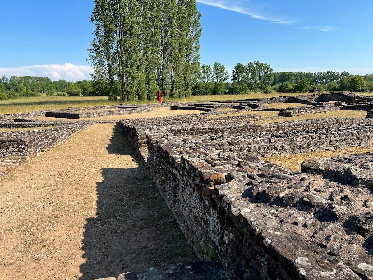
The site stretches for more than 500 metres from north to south and covers over forty hectares. The ground falls from approximately 45 metres around the theatre and market building to about 40 metres near the baths. A rocky ridge rising to roughly 95 metres lies to the west, while the Loir runs about 600 metres away. Marshy ground occupied parts of the ancient complex, especially around the great temple and toward the river. The principal monuments share a broadly common orientation, and the surviving remains extend across a landscape in which funerary, religious, commercial, bathing, and water-management features were closely associated.
Protohistoric funerary and cultic remains
The Bronze Age and Hallstatt necropolis extended beneath the later theatre, the western galleries of the market building, and the northern part of the great temple’s sacred precinct. At least eight tumuli lay beneath the theatre. They included burials in the ground and one burial with a funerary urn. Five recumbent megaliths were also found, including one that was recut when the theatre was constructed. Most of the protohistoric graves were individual cremations, accompanied by glass beads and other objects regarded as rare in western Gaul.
An earlier indigenous wooden cult structure may have preceded the great temple. Weapons may first have been displayed there before being sacrificed and placed in the nearby marsh. An oval enclosure about 61 metres across lay 70 metres north of the theatre. Concentric ditches bounded it, and an entrance opened to the south. Other possible enclosures included a circular structure at least 20 metres in diameter south of the theatre, a large trapezoidal enclosure with a double ditch southeast of the temple, and an elongated structure southwest of the temple.
The Iron Age weapon deposit contained 73 metal objects, including swords, scabbards, axes, lances, shield bosses, cauldron handles, and cauldron fragments. Animal bones, mainly from pigs and cattle, accompanied the deposit. The sword scabbards carried incised curved decoration, with motifs that may evoke mythical animals. Four axes were currency-bars, including one socketed example. Together with lances and shield bosses, they were estimated to measure between 50 and 60 centimetres long. Semi-finished domestic metal objects, especially cauldron handles and grips, appeared alongside a smaller number of complete vessels.
Further deposits lay in the marshy ground between the D 305 road and the great temple. They included weapons, tableware, and animal skulls dispersed through soil layers. These finds connect the later monumental landscape with the earlier ritual use of the site.
Public and commercial buildings
The theatre
The theatre is a semicircular Gallo-Roman building about 63 metres in diameter. Its second phase could accommodate approximately 3,000 spectators. Wooden seating formed the cavea, the audience area, as shown by numerous nails and sockets for beams. The seats were supported by concentric masonry arches with relatively shallow foundations. The outer cavea wall survived locally to a height of about 2 metres when modern investigations began, while the highest seating may originally have risen more than 12 metres.
Three principal passageways, or vomitoria, gave access to the seating, supplemented by four secondary passages. A balteus, the low barrier separating the audience area from the central orchestra, stood no more than 1 metre high. In the first phase, a small stage building measuring 10.60 by 5.20 metres stood centrally against the straight rear wall. Three possible decorative niches were set into its inner face, and a timber gallery may have provided access to the passageways.
The theatre was built mainly with rubble facing of reddish sandstone, around a core of sandstone and flint nodules bound with mortar. Brick was used more sparingly. Some bricks carry finger marks and notches. White sandstone rubble formed decorative patterns on the cavea wall, the stage wall, and the inner walls of the main passageways. Projections at the base of the curved wall served structural and decorative purposes. The first phase appears to have been laid out with a square measuring 36 Roman feet, with the main dimensions of the building, cavea, and orchestra based on multiples of the square’s side or diagonal.
A remodelling in the second century added semi-annular walls faced with lighter sandstone rubble. Some were inserted between earlier structures, while others reduced the orchestra. One contained a lodge at the end of a passageway, perhaps for an elite benefactor who financed the work, or alternatively the base of a small cult building. The changes created distinct seating divisions called maeniana and cunei, an unusual arrangement for a Gallo-Roman theatre in western France. The small stage building was moved inside the orchestra and received two internal partition walls. Performances may have included games, stage performances, or cult ceremonies.
The market building
The market building stood west of the theatre. Its first phase, erected toward the end of the first century, consisted of a large tiled hall with a small square room at each end of its long sides. These rooms may have served as offices for registration or payment. About fifty years later, the structure was enlarged and converted into an open parallelogram-shaped courtyard measuring 68 by 42 metres. Two pairs of covered galleries, each about 3.40 metres wide, opened onto the courtyard through colonnades. Thin walls probably supported wooden upper elevations and tiled roofs. A fire affected the building before or after its enlargement.
A fountain stood at the centre of the first-phase hall. A wooden pipeline, held together by iron hoops, supplied it from a route traced for approximately 100 metres toward the aqueduct. Excavation produced about 24,000 fragments of butchered animal bone, around 15,000 oyster remains, at least 540 coins, toiletries, tools, statuettes, and fragments of fine tableware. The mammal bones included 6,697 cattle remains, 1,155 goat or sheep remains, and 1,083 pig remains. Beef portions had been selected in a different way from the caprine and pig remains, suggesting that animals were slaughtered and butchered between the theatre and market building before meat was cut for sale. The galleries may have contained stalls selling food for consumption away from the site.
The structure was initially identified as a macellum, a Roman market building often associated with meat and other foodstuffs. Later interpretations have proposed a wider meeting place comparable in some respects to a forum, while another interpretation regards it primarily as an area for economic exchange rather than a political or administrative forum.
The sacred precinct
The great temple
The great temple was a rectangular Celto-Roman building measuring 27 by 15 metres. Its square inner chamber, or cella, measured 7.60 metres on each side, and the whole structure may have reached about 15 metres in height. A surrounding gallery was enclosed by a wall that was solid on three sides. The eastern side opened onto a pronaos, an entrance porch, reached by a staircase. The temple stood on a podium, parts of which retain large sandstone blocks.
The eastern porch had a six-column front, known as a hexastyle colonnade. Two additional columns on each side connected it with the gallery wall, with intervals of 2.50 metres. This arrangement created a pseudoperipteral design, giving the impression of a surrounding colonnade while incorporating columns into the building’s walls. The temple may have been oriented toward the rising sun on April 23 and August 19, dates associated in Rome with the Vinalia, festivals connected with wine, and the cult of Jupiter, the chief Roman god.
The roof was probably tiled. A fired or unfired clay object bearing a grid-like inscription may represent a tilemaker’s accounting system. Fallen sections of wall allowed the gallery’s exterior decoration to be reconstructed to a height of more than 14 metres. Light and dark sandstone rubble formed chevrons and diagonal lines in opus spicatum, a herringbone arrangement of masonry, separated by rows of terracotta. Exterior pilasters continued the line of the porch colonnade.
The inner gallery wall carried multicoloured frescoes with festoons and garlands, accompanied by stucco decoration. Similar treatment appeared on the gallery-facing exterior of the cella walls. A square peribolos, the enclosing sacred precinct, measured 90 metres on each side. Its wall contained eight outward-opening tiled exedra niches, recessed or projecting semicircular spaces, each framed by two pilasters. The exedras probably held paintings applied to roof tiles fixed to the wall.
A northern entrance, preceded by a porch measuring 4 by 2.50 metres, linked the precinct with a large galleried building to the north and aligned with the second temple. A probable eastern entrance faced the temple staircase. Ten metres east of the entrance stood a rectangular basin with rounded short ends, measuring 9.43 by 4.70 metres. Its small-rubble walls enclosed the basin, which was heavily damaged by unauthorized excavation in 1974 and later fully reconstructed. It may have collected water filtering through the precinct. An alley 4 metres wide ran between the basin and the eastern precinct wall toward the temple staircase.
The temple’s architecture and decoration have some similarities to the Maison Carrée at Nîmes, a well-preserved Roman temple, although the masonry and interior arrangement differ. A fragment of a statue of Victory, together with the temple’s design, suggests a possible connection with the imperial cult or a warrior cult.
The second temple and northern building
A second, unexcavated temple lay north of the great temple. It appeared to measure 12 by 9.5 metres and stood on a podium reached by a staircase. Its inner chamber had not been identified. The marshy area containing the Iron Age weapon deposits separated it from the great temple.
Aerial photography revealed a 40-metre-long building with galleries north of the great temple. A doorway in the temple precinct connected the two structures. The building had not been studied by 2016 and may have accommodated pilgrims. At least four additional buildings were identified by aerial prospection in the late 1980s and early 1990s. Their dates, forms, and functions remained uncertain; one may have been a domus or mansio.
Baths and water management
The baths
The baths formed a complex measuring 35 by 30 metres. Their first construction belonged to the last quarter of the first century. An enlargement during the first half of the second century added rooms on the south, including an apodyterium, or changing room, and a cold pool in an exterior apse west of the frigidarium, the cold room or bath.
In their final form, the baths covered 926 square metres and followed an asymmetrical plan organized around a central area. An eastern entrance was protected by an awning carried on wooden posts. A central palaestra, or exercise court, measured 15 by 14.20 metres and was surrounded on three sides by a gallery or portico. The western wing contained the heated rooms, arranged from the frigidarium in the south to the caldarium, the hot room or bath, with a hot pool in the north. Another large room may have served for sport.
The heated rooms used hypocausts, underfloor heating systems supplied by a praefurnium, or furnace opening. Wastewater passed through a dry-stone conduit into a masonry channel that was partly adapted as latrines and ran southward. T-shaped and L-shaped metal clamps secured the insulation and heating systems in the walls. Hypocaust bricks were later reconstructed. Fragments of marble, mosaic, plaster, and moulding survive, including marble from local and regional sources and from distant quarries such as Saint-Béat.
A kiln, lime pits, a hut, and postholes for scaffolding occupied the baths’ courtyard and may relate to construction work. The complex also yielded fine tableware, including a fragment decorated with a figure, rosettes, and plant motifs.
The aqueduct and drainage system
The aqueduct ran entirely underground and supplied the market building to the north and the baths to the south. Its reconstructed route extended for 4.5 kilometres, following the contours between approximately 55 and 50 metres in elevation. The masonry channel measured 0.24 by 0.27 metres and lay at the base of a trench between 0.30 and 5 metres deep. White sandstone slabs covered it, and at least one inspection chamber formed part of the system. Construction required an estimated 7,000 tonnes of stone and concrete and was probably contemporary with the baths.
The principal water source was the spring of La Fontaine de Chenon. The Saint-Hubert spring at Coulongé may have supplemented its flow. Halfway up the hillside west of the baths, a wooden reservoir measuring 2 by 2 metres regulated pressure and distributed the water. The aqueduct’s estimated flow was 15 litres per second, with an average gradient of approximately 0.63 metres per kilometre. Its water contained enough carbon dioxide to reduce the formation of lime deposits and the risk of blockage.
Within the complex, wooden pipes joined by metal fittings distributed water, with lead conduits used in addition. The system served the market building, baths, and possibly the northern galleried structure. Overflow may have been directed into the baths’ drainage channel to flush the latrines. Drainage works west of the temple crossed the sacred precinct and included possible wooden pipes bound with iron hoops and dry-stone channels covered by sandstone slabs. The temple basin probably connected with this network, while the precinct floor was made of compacted limestone covered with sand and sloped to carry roof water away from the foundations.
A collector west of the baths drained the surrounding ground, received water from the temple and precinct upstream, and evacuated bath wastewater through a branch. Its masonry channel was partly converted into latrines and continued toward the Loir, although its course beyond Cherré is unknown. Some recovered cover slabs had circular notches. Together, these installations show how the complex managed water across its marshy setting while supplying its public and religious buildings.