Sufetula Archaeological Site: A Roman and Byzantine City in Tunisia


Site at a Glance
- Rating
- 4.6
- Popularity
- Low
- Country
- Tunisia
- Primary era
- Classical
- Eras represented
- Classical, Medieval
- Civilizations
- Byzantine, Roman
- Site type
- City
On this page28 sections
History
Sufetula Archaeological Site is the remains of a Roman and Byzantine city in Tunisia, at Subaytilah. Founded during the Flavian period, probably in the third quarter of the first century AD, it reflects Rome’s settlement and administrative policies in a region inhabited by the Musunii, an indigenous North African population that still followed a largely nomadic way of life. The city later became a municipium and a colonia, and its position on the road between Carthage and Theveste helped it develop as a regional crossroads, commercial center, and agricultural town.
Roman foundation and civic development
Sufetula, also known as Sufetula Musuniorum, has been associated with veterans of Legio III Augusta. Another interpretation presents it as a new Roman colonial foundation created to settle and integrate the Musunii. In this view, the city represents an unusual application of Roman urban organization to the sedentarization of a non-citizen indigenous community living under Roman rule.
The city’s economy was closely connected with agriculture, especially olive cultivation and the production of olive oil. During the Roman Imperial period, Sufetula expanded and prospered. Public monuments and private buildings were built or enlarged, while its position in Byzacena, a Roman province centered in central Tunisia, supported continuing economic activity. Municipal institutions followed Roman practice, and inscriptions mention offices such as that of city curator, an official responsible especially for municipal administration and financial oversight. Aelius Rusticus held this office during the reign of Septimius Severus.
Christianization and Late Antiquity
From the fourth century onward, Sufetula became an important Christian center. Churches, chapels, baptisteries, and episcopal buildings indicate an organized Christian community. The city was also involved in religious disputes, including Donatism, a rigorist Christian movement that developed in North Africa and contested the status of clergy and sacraments associated with persecution and readmission to the church.
Christian communities were persecuted during the Vandal period. An episode dated to 484 involved a bishop named Presidius. Agricultural and ceramic production nevertheless continued in the surrounding territory into the late fifth and early sixth centuries. The city’s churches and funerary monuments belong to the wider transformation of Roman North Africa during Late Antiquity, the transitional period from the third to the seventh centuries.
Byzantine rule and the battle of 647
After Justinian’s Byzantine reconquest of North Africa, Sufetula received a Byzantine garrison. Earlier buildings were reused or fortified as military conditions changed. In the sixth century, Sufetula became the capital of the Byzantine province of Byzacena and the headquarters of the patricius Gregory. In 646, Gregory declared independence from Constantinople.
In 647, Byzantine forces led by Gregory confronted an Arab-Muslim army advancing from Tripolitania near Sufetula. Gregory was defeated and killed. The battle marked a decisive stage in the decline of Byzantine rule in North Africa and the transition from Late Antiquity to the medieval period. Sufetula continued to be occupied for some time afterward, although the date of its final abandonment remains uncertain.
During the Byzantine period, the Forum was converted into a fortress, following a pattern also found at other Roman towns in the region. Fortified buildings developed in the northern sector, and the settlement became more dispersed and defensible than the earlier concentrated Roman town. Roman structures were adapted through the blocking of openings, the strengthening of walls, and the addition of upper stories. Olive pressing continued during the Late Antique and Byzantine periods.
Archaeology and preservation
Investigations began at Sufetula in 1883, and professional excavations are documented from 1906. Early campaigns continued until about 1921 or 1922. Further work took place sporadically from 1941 and in campaigns between 1954 and 1971, with an interruption from 1955 to 1963. Noël Duval studied the Christian basilicas during the 1950s and 1960s, and Fathi Béjaoui resumed research in the 1990s.
Since 2022, a Tunisian-French archaeological mission has examined the city’s urban development, including residential quarters, houses, shops, workshops, and city blocks. Geophysical surveys have identified streets and structures that remain buried. Excavation has concentrated particularly on public and religious monuments, while substantial residential and artisanal areas remain insufficiently studied. The accessible archaeological area covers about 20 hectares, compared with approximately 50 hectares for the ancient city. A modern road and a village established during the French Protectorate removed part of the ancient southwestern quarter. Repairs and restoration have preserved architectural structures and original materials, and the ruins retain a high degree of stated authenticity. Sufetula was submitted to UNESCO’s Tentative List on 15 April 2021 under cultural criterion (ii), emphasizing the exchange between the Roman colonial urban model and an indigenous nomadic population.
Remains
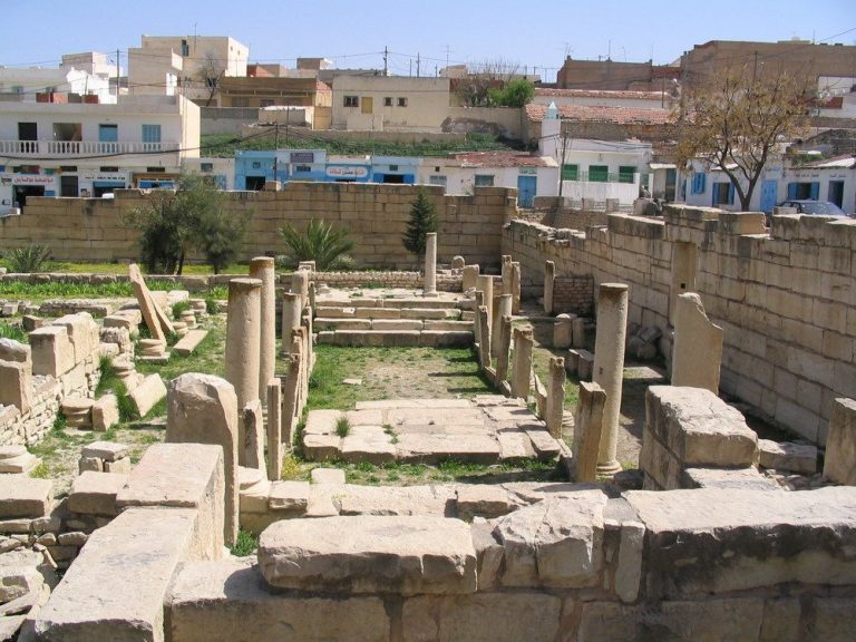
Sufetula occupied a fairly level plateau within a bend of the Oued Sbeïtla, immediately below a plentiful perennial spring. The ancient city covered about 50 hectares and followed a regular grid, with straight streets running approximately north to south and east to west. These roads crossed at right angles to form rectangular city blocks. Principal streets were paved and incorporated drainage and water-supply conduits. The surviving urban area includes civic buildings, baths, theatres, religious complexes, houses, workshops, agricultural installations, and fortified structures from the Byzantine period.
Water systems and civic center
Hydraulic works
The spring supplied a hydraulic system that included an aqueduct bridge, public and private cisterns, lead and terracotta pipes, drains, and monumental fountains. The aqueduct bridge crosses the Oued Sbeïtla for about 50 metres. It rests on three piers and is cut into or anchored in the rock. Work carried out from 1907 to 1911 restored the bridge.
The Forum and Arch of Antoninus Pius
The Forum formed a rectangular civic complex measuring approximately 37.20 by 34.75 metres, with part of its original limestone paving still preserved. Porticoes surrounded it on three sides, while the western side contained the Capitoline temple complex. The wider Forum enclosure measured about 70 by 67 metres. Corinthian columns stood in the porticoes, with thirteen on the southeastern side and fifteen on each of the other sides. They reached about 5.5 metres in total height. Two galleries, each around 6 metres wide, extended toward the Capitoline complex and led to small rooms measuring approximately 4 to 6 metres across.
Access to the Forum was through the Arch of Antoninus Pius, a monumental three-bayed gateway preceded by four steps. Its inscription dedicates the arch to Antoninus Pius and his two adopted sons, Lucius Verus and Marcus Aurelius, and dates it to AD 139. Four columns on pedestals, Corinthian capitals, lateral niches, and an upper section bearing the inscription formed part of the gateway’s design.
Capitoline complex
The Capitoline complex occupies the western end of the Forum on a raised platform. Its identification as the Capitolium remains unconfirmed but is widely accepted. The complex consists of three separate temples associated with Jupiter, Juno, and Minerva, the three principal gods of the Roman state. Each temple stood on its own podium. Passages divided the podia at ground level, while a platform in front joined them above and could also have served as a speaking platform.
Each temple had a four-column façade and a pediment. Stairs provided access to the lateral temples, while the central cella, the principal enclosed chamber of a Roman temple, had no steps.
Baths and public entertainment
Great Baths
The Great Baths were built in the early third century and contained separate summer and winter sectors divided by entrance and circulation areas. Their facilities included changing rooms, an open exercise court called a palaestra, cold, warm, and hot rooms, service spaces, and bathing pools.
The palaestra measured about 27 by 17 metres. It was an open-air court surrounded by a portico and paved with geometric mosaics. The summer sector included a large cold room, or frigidarium, divided into two rooms, each with a pool. Warm rooms followed, together with a cross-shaped heated room. The winter sector contained a changing room, a frigidarium with two square rooms and a pool, warm rooms, and a cross-shaped hot room, or caldarium, with several pools.
The heated rooms used raised floors supported by small brick pillars, called pilae, which allowed hot air from furnaces to circulate beneath the pavement. Wall conduits distributed heat through the rooms. At least four smaller bath complexes have also been identified elsewhere in the city. One installation was incorporated into a private house partly destroyed by a modern road. Some baths remained in use during Late Antiquity and may have continued until AD 647.
Theatre and amphitheatre
The theatre stood beside the ravine formed by the river on the eastern side of the city. Its seating used the natural slope. Its surviving appearance is substantially the result of modern reconstruction and restoration.
The amphitheatre lay at the northern or northwestern edge of the ancient city. It was circular or elliptical in plan and is now very poorly preserved. Parts of the arena and access openings survive, with some masonry incorporating reused materials.
Arches, streets, and fortifications
Monumental gateways
The Arch of Diocletian, also called the Arch of the Tetrarchy, stood in the southeastern sector as a monumental single-bayed gateway. Its massive piers contained niches and were decorated with columns and Corinthian pilasters. An inscription commemorated the emperors of the first Tetrarchy, the system of rule established by Diocletian in the late third century that divided authority among four emperors. The arch was restored in 1910 and 1911.
An arch dedicated to Septimius Severus marked the northern entrance to the city, probably in the early third century. Its surviving remains are limited, and the monument is less well preserved than the Arch of Diocletian.
Byzantine fortified buildings
At least three Byzantine fortified buildings occupied the northern sector, two of them relatively well preserved. Earlier structures were adapted by blocking lower-level openings and reinforcing their walls. The buildings contained several rooms, wells or other water-supply installations, and stairs or other arrangements for movement between levels. The same quarter included oil presses, bath installations, and Christian buildings, reflecting the continued use and adaptation of earlier urban structures.
Residential and commercial quarters
House of the Four Seasons
The House of the Four Seasons was a large residence in the northern sector, probably an affluent Late Antique dwelling. Its name comes from a mosaic depicting the Four Seasons, now preserved in the Bardo National Museum. The decoration and its technique place the remodeling of the house in the late fourth or early fifth century. The residence continued in use during the Byzantine period.
Temple and productive areas
A small unidentified temple stood in the northwestern sector opposite the House of the Four Seasons. It was a four-column, front-columned building with a cella, a podium, and a four-column façade. Its deity and dedication remain unknown. Across the city, houses, shops, workshops, agricultural installations, oil presses, and circulation spaces formed the residential, commercial, and artisanal quarters. Shops bordered some routes near the Forum, while oil presses in the city and surrounding area show the continuing importance of olive processing.
Christian buildings and episcopal complexes
Basilica of Bellator and Chapel of Jucundus
The Basilica of Bellator was a three-aisled church measuring approximately 35 by 15 metres. Two rows of eight pairs of columns separated its aisles. The building had two side entrances and apses at the ends of the central nave. Several architectural modifications changed its form over time. Together with associated buildings and the Chapel of Jucundus, it formed part of an episcopal complex.
The Chapel of Jucundus began as a baptistery attached to an earlier rectangular Christian building. Its baptismal basin had an unusual oval form and was reached by two stairways. After another installation was built, the baptistery became a chapel associated with Bishop Jucundus, whose burial was located there.
Basilica of Vitalis
The Basilica of Vitalis measured approximately 50 by 25 metres and had five aisles. Its richly decorated baptistery contained a mosaic cross, vegetal motifs, and an inscription recording a votive offering by Vitalis and Cardela. The basilica and the Basilica of Bellator formed a Christian double-church complex.
Church of the Priest Servus
The Church of the Priest Servus was built in the courtyard of an earlier pagan structure. Part of that building survives as a square cella measuring about 8 metres on each side, and its interior was reused for the church’s baptistery. The church had several aisles and an apse. Sarcophagi and funerary inscriptions were found in the surrounding area, including an inscription identifying the presbyter Servus.
Church of Saints Gervasius and Protasius and Saint Tryphon
The church dedicated to Saints Gervasius and Protasius and Saint Tryphon had three aisles and three entrances in its façade. One entrance has been restored. Its apse was first semicircular and later rectangular, while a corridor in front of it accommodated the choir and altar.
Funerary and rural religious buildings
Basilica of Saints Sylvanus and Fortunatus
The Basilica of Saints Sylvanus and Fortunatus stood about 600 metres southwest of the Capitoline temples in a funerary sector. It measured approximately 25 by 20 metres and contained several aisles, a martyrium, and spaces connected with the cult of the martyrs. Two levels of mosaic paving carried funerary inscriptions. An offering dedicated to Sylvanus and Fortunatus indicates a commemorative and pilgrimage function.
The basilica incorporated funerary stones and epitaphs taken from the surrounding cemetery. A semicircular apse contained a collective bench for clergy, known as a synthronos. A side room held graves with epitaphs dating to the reign of Justinian.
Church of the Pompeani
The Church of the Pompeani was built against the southern enclosure of the Forum, above an earlier structure whose function remains uncertain and may have been connected with the civic basilica. It had a central nave, side aisles, two spaces interpreted as choirs, mosaic flooring, and several Christian funerary inscriptions. The church reused an earlier mosaic basin decorated with marine animals, forming part of the wider reuse of Roman architectural elements in Christian buildings.
Chapel of Bishop Honorius
A chapel associated with Bishop Honorius stood about 3 kilometres from the archaeological site and may have belonged to an ancient village or rural estate. It had three aisles and four bays divided by double colonnades. Two mosaics from the chapel are preserved in the Bardo National Museum. One decorated the bishop’s tomb, while another depicted a jeweled cross surrounded by foliage.