Loulon: A Byzantine and Seljuk Frontier Fortress in Turkey


Site at a Glance
- Rating
- 5
- Popularity
- Very Low
- Country
- Turkey
- Primary era
- Medieval
- External website
- Open
- Eras represented
- Medieval
- Civilizations
- Byzantine, Seljuk
- Site type
- Military
- Remains
- Fort
On this page10 sections
History
Loulon is a frontier fortress in Turkey that controlled the northern exit of the Cilician Gates, a major mountain pass through the Taurus range linking central Anatolia with Cilicia. During the eighth and ninth centuries, it stood between the Byzantine Empire and the Abbasid Caliphate, the Islamic dynasty ruling from Baghdad, and guarded the main road between the Byzantine town of Tyana and Arab-held Tarsus.
A Byzantine-Arab frontier fortress
Loulon changed hands repeatedly during the Arab-Byzantine wars. It formed part of a chain of fortifications positioned along both sides of the Taurus-Antitaurus range. The fortress also protected regional mines that supplied silver for coin production and materials for weapons. Its position gave it a military role beyond the immediate hilltop, since control of Loulon affected movement through the mountain pass and along the road toward Cilicia.
The settlement may have been established by inhabitants of nearby Faustinopolis, an earlier town originally known as Halala. Faustinopolis appears to have been abandoned during the early Muslim incursions into Asia Minor. An older interpretation connected the medieval name Loulon with Faustinopolis, while more recent scholarship relates it to the Hittite name Lolas for the local mountain range. Arabic writers called the fortress Lu’lu’a, and it has also been identified with Hisn al-Saqaliba, meaning “Fortress of the Slavs.” That name may refer to a garrison of Slavic soldiers, including men who had defected from Byzantine service and were installed there by the caliphs.
The beacon network
Byzantine writers particularly associated Loulon with a line of nine beacons that relayed frontier messages to Constantinople. Leo the Mathematician, a ninth-century Byzantine scholar linked with mathematical learning, devised the system under Emperor Theophilos, who reigned from 829 to 842. Identical clocks at Loulon and at the lighthouse of the Great Palace in Constantinople divided the day into twelve hourly signals. Each signal represented a particular message. Byzantine accounts say that Emperor Michael III later discontinued the system for a frivolous reason, although that explanation may be a hostile later story intended to damage his reputation.
Abbasid and Byzantine contests
Arab historians attribute Loulon’s capture to the Abbasid caliph Harun al-Rashid in 805. It may already have been under Arab control by 782, when Arab forces were able to cross the Cilician Gates freely. The Byzantines recovered the fortress sometime after 811.
In September 832, the garrison surrendered to the Abbasid caliph al-Ma’mun after a prolonged siege. In late 859, Emperor Michael III tried to persuade the unpaid garrison to surrender. The soldiers initially appeared willing, but an officer sent to take possession in March 860 was captured and handed over to the caliph. In 878, during the reign of Emperor Basil I, the Byzantines finally recovered Loulon. The Arab garrison had again gone unpaid because Urkhuz, the governor of Tarsus, had embezzled money intended for its salaries. Loulon remained Byzantine until the Seljuk conquest of much of Asia Minor.
Seljuk, Ilkhanid, and Ottoman frontier roles
Between 1216 and 1218, the Seljuk sultan Kaykaus I captured Loulon from the Armenian Kingdom of Cilicia. The Seljuks strengthened its fortifications and made it an important way station on the road between Sis and Kayseri. Later in the thirteenth century, the region’s rich silver deposits supported minting at Loulon. The Seljuks of Rum, the Seljuk dynasty that ruled much of Anatolia, and the Ilkhanids, the Mongol ruling dynasty of Iran and neighboring regions, struck silver coins there under the mint name Lu’lu’a.
Loulon again occupied a frontier position during the late fifteenth-century conflicts between the Ottoman Empire and the Mamluks, the military ruling dynasty of Egypt and Syria. Lu’lu’a served as the advanced Ottoman outpost, while the fortress of Gülek held the corresponding Mamluk position on the opposite side of the Taurus frontier.
Remains
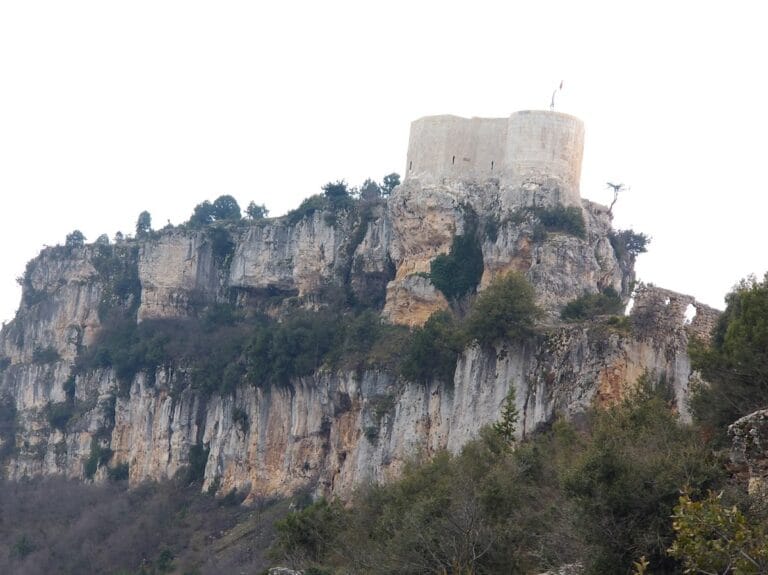
Loulon’s exact location remains debated. W. M. Ramsay placed the fortress on a steep hill about 300 metres high west of modern Porsuk in the Çakit valley. Modern scholars instead identify it with a rocky hill approximately 2,100 metres high, about 13 kilometres north of Porsuk between Çanakçı and Gedelli. This proposed site has summit ruins that fit the role of a high frontier fortress and preserve traces of occupation from the ninth to the twelfth centuries.
Hilltop fortifications
Enclosing walls
On the proposed hilltop, surviving wall ruins enclose an area of approximately 40 by 60 metres. The fortifications define the compact summit stronghold, whose defenses were strengthened by the Seljuks after their capture of Loulon between 1216 and 1218. The remaining walls preserve the outline of the fortified area while reflecting the site’s continued military use across different political regimes.
Barracks and cisterns
Traces of barracks and cisterns survive on the summit. These remains date from the ninth to the twelfth centuries and represent the facilities that supported the garrison. Their position within the enclosed hilltop area helps identify the proposed site as a functioning military station rather than only a signal point.
Beacon landscape
The hilltop has an unobstructed view of Hasan Dağ, commonly identified with Mount Argaios. That mountain was the second station in the beacon line connecting Loulon with Constantinople. The clear sightline between the two high points explains how Loulon could participate in the relay system that carried coded hourly signals from the frontier toward the Byzantine capital.