Burg Siersburg: A Lorraine Territorial Castle in Germany


Site at a Glance
- Rating
- 4.6
- Popularity
- Low
- Country
- Germany
- Primary era
- Medieval
- Eras represented
- Medieval, Early Modern, Modern
- Civilizations
- Duchy of Lorraine, Holy Roman Empire
- Site type
- Military
- Remains
- Castle
On this page16 sections
History
Burg Siersburg, also called Burg Siersberg, is a high-medieval hilltop castle ruin in Germany, at Siersburg in the municipality of Rehlingen-Siersburg, Saarland. Probably established in the eleventh century by Sigebert, Count of Saargau, it became a territorial castle of the Duchy of Lorraine and controlled navigation on the Saar as well as major routes between Italy, Strasbourg, Flanders, Metz, Tholey, and Mainz.
Origins and Lorraine rule
The castle was first mentioned in 1175. After an earlier period under the successor dynasty of the Counts of Saarbrücken, it passed to the Dukes of Lorraine after 1150. Around 1175, Archbishop Arnold I of Trier captured Siersburg and compelled the duke of Lorraine to accept it as a Trier fief. In 1334, Duke Rudolf of Lorraine had to recognize Archbishop Baldwin of Luxembourg as feudal overlord. Lorraine recovered its freedom from Trier’s feudal authority only after Baldwin’s death.
Under Lorraine control, Siersburg served as one of the duchy’s territorial castles. A territorial castle, or Landesburg, was controlled by a ruling prince for administration, defense, and the exercise of authority. Lorraine administered its rights in the Merzig-Saargau condominium from the castle. This was a jurisdiction shared by Trier and Lorraine. In dangerous periods, nearby inhabitants used the fortress as a refuge and helped maintain its defenses.
The Siersberg-Dillingen lordship
Lorraine granted the castle as a fief to a noble family that adopted the name von Siersberg, first recorded in 1136. Arnold II von Siersburg was identified in 1341 as lord of Dillingen, connecting the Siersburg lordship with the Old Castle at Dillingen on the opposite bank of the Saar. The male line ended with Ladwein von Siersberg, Lord of Dillingen, who died in 1558. By then, the family had increasingly withdrawn to Dillingen and retained only a castle house at Siersburg.
After Ladwein’s death, his sister Lisa inherited the family property and passed it through her marriage to Johann von Braubach. The Duke of Lorraine took over much of the property on the castle plateau. Other minor noble families occupied about ten castle-men’s houses and supplied the garrison. These families included the Esch, Kern von Siersberg, Bechel von Siersberg, Criechingen, Dalheim, Haracourt, Fust von Stromberg, and Zand families. A castellan, later described as a captain or local administrator, represented Lorraine at the castle and in the associated Siersberg district. A castle man, or Burgmann, was a noble resident with garrison and related duties.
War, occupation, and decline
During the Thirty Years’ War, the European conflict of 1618–1648 involving religious, dynastic, and territorial struggles, French Marshal Henri de La Ferté-Senneterre captured Siersburg in 1634 and used it as a base. The surrounding villages faced heavy war contributions, while peasants were also required to supply the troops. Imperial forces under Lieutenant General Matthias Gallas recaptured the castle in 1635. France regained it in 1643, Lorraine retook it in 1650, and France captured it again in 1651 after briefly shelling the walls.
The Treaty of Vincennes returned Lorraine to its duke and ended the immediate Lorraine-French crisis, although France occupied Lorraine again in 1670. During the French withdrawal in 1677, French troops blew up parts of the already ruined castle. This accelerated its decay and ended its military importance. The treaty had placed Siersburg under France in 1661, but the castle remained the seat of the ducal-Lorraine Siersberg district into the eighteenth century, and maintenance work continued.
During the War of the Austrian Succession, the garrison repelled an attempted capture by Pandur Colonel Johann Daniel von Menzel, although his forces plundered the surrounding villages. In the seventeenth century, the Zand von Merl and Bockenheim families held castle-men’s houses on the plateau. Lorraine seized the Bockenheim property as a reverted fief after 1664 and granted it in ruined condition to François Forget de Barst de Bouillon in 1713. The Zand house passed through Baron von Blittersdorf to the Maurice family.
A lightning strike on the tower late in the eighteenth century contributed to the complex’s deterioration. The French Revolution brought largely destructive changes in 1793. The property then passed to the French state and was auctioned, while the plateau still appears to have been inhabited at the beginning of the nineteenth century.
Telegraph station and conservation
From 1813, Siersburg served as a signal station on Napoleon’s optical state telegraph line between Metz and Mainz. The system, devised around visible movable signal arms, transmitted coded messages through a chain of mutually visible stations before electrical telegraphy. Its line connected Paris with Mainz and used three wooden signal bars to transmit up to 196 signs. The system was interrupted after Prussian forces under Gebhard Leberecht von Blücher conquered the territory and was soon abandoned, leaving the station to decay.
The region had been assigned to Prussia by the Congress of Vienna, after the castle had previously been incorporated into the French Moselle department. Local residents used the ruins as building material until Prussian military authorities intervened in 1817 because they intended to use the tower as a military signal post.
The tower was first repaired in 1911, when its cornices were relaid and parts of the masonry were repointed. After it threatened to collapse in the 1930s, the Siersburg Heritage and Tourism Association renovated its exterior in 1938–1939. Interior work followed in 1955–1956 after the Second World War. The outer walls were repaired in 1967–1969 and 1975–1978, with work on the gate area and archaeological excavation that revealed cellar and guard rooms.
Since 1937, the castle had been owned by former German Chancellor Franz von Papen, who made it available to the municipality without charge. Municipal care continued until ownership passed to the municipality on 26 April 1979 through a land exchange involving 4.3641 hectares. Archaeological work accompanying repairs to the southwest ring wall in 2009 uncovered a buried latrine and a group of finds that helped clarify the castle’s medieval occupation. The associated window glass was restored in 2015.
Since 1998, the ruins have also been used for summer festivals, an annual medieval market, and an open-air cinema. These are modern uses of the site rather than survivals of its medieval functions. Local traditions tell of an underground passage to the castle on the Litermont, three knightly brothers who exchanged trumpet calls between Siersburg, the Schaumberg, and the Litermont, and a love potion connected with a castellan’s daughter. Another tale describes a sorcerer who supposedly made a knight’s horse lame by placing enchanted coffin nails in its hoofprint.
Remains
Hilltop setting and overall layout
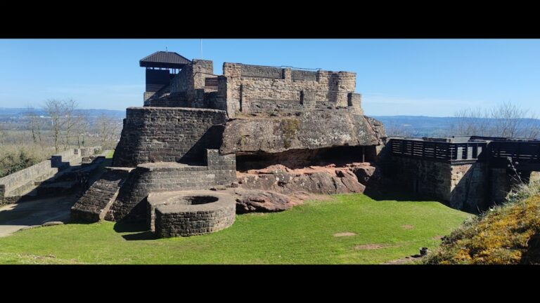
Burg Siersburg occupies a steep hilltop on the Siersberg at about 297.8 metres above sea level, between the Saar and Nied valleys and above the Nied shortly before it joins the Saar. The plateau measures approximately 130 by 80 metres, while the visible remains cover about 120 by 70 metres. The elevated position overlooks Siersburg, Rehlingen, Beckingen, and Dillingen.
The hill stands beside a geological fault where Upper Buntsandstein, a sandstone formation, meets Upper Muschelkalk, a limestone formation. Contrasting erosion has shaped the surrounding terrain, and the fault line can be seen in the saddle between the Siersberg and the neighbouring Gauberg, which reaches approximately 308.2 metres. The castle’s original three-part arrangement consisted of the Herzogburg, or ducal castle, the Moritzburg, and the Marienburg. Leveling on parts of the plateau has made this division less distinct.
Defenses and entrance
The principal approach came from the northeast, crossing the eastern main defenses before reaching a moat depression between 6 and 10 metres wide. A drawbridge with obstruction barriers led to a gate bastion, a projecting fortified entrance structure. Four successive gates secured the way into the ducal section.
The ducal section was divided from the rest of the castle by a wall-and-ditch system. Its surviving traces form a transverse hollow across the plateau. The enclosing walls were probably about 6 metres high and 1.5 metres thick, with openings for firing. Surviving defensive features include the keep tower, sections of the castle walls, and the gate area. Excavations also exposed cellar and guard rooms.
The ducal castle
Keep tower
The repaired keep is a square tower approximately 9.2 metres on each side and about 16.3 metres high. A keep was the principal defensive tower and a stronghold within a medieval castle. The surviving masonry incorporates a palas, the main residential and representative building, whose former attachment is indicated by beam holes and the remains of a stone fireplace.
The tower’s present entrance at ground level was cut through a wall 2.6 metres thick in the eighteenth century, when a fourth story was added. Its third story, reached through a Gothic doorway about 9.7 metres above ground, was built approximately between 1350 and 1450. An internal concrete spiral staircase has 83 steps and passes through intermediate levels in the third and fourth stories to an observation platform protected by a roofed glass structure.
Chapel and administrative area
The area around the tower contained the ducal administration, a chapel, and the castellan’s residence. The chapel was first mentioned in 1233, when Duke Matthew II of Lorraine gave it to the Abbey of the Holy Cross at Busendorf. Its patrons were Saint Sebastian, Saint Blaise of Sebaste, and Saint Donatus.
Moritzburg and Marienburg
Moritzburg
The central section, known as the Moritzburg, contains a monument to the de Maurice family with a Pietà, a devotional image of the Virgin Mary holding the dead Christ. The de Maurice family occupied this part until moving to a new residence in nearby Hilbringen in 1745.
Marienburg
The southwest section, called the Marienburg, was occupied from 1760 by Claude Ledans de Saint Marie, a French regimental physician who acquired it through marriage.
Archaeological finds and reconstructed window
Excavations in 2009 along the southern castle wall exposed a buried latrine. It contained animal bones, pottery fragments, two nearly complete clay jugs, and a footed beaker without a handle. The work also recovered Gothic window fragments, including a mass of lead strips, sand, and glass shards measuring approximately 45 by 30 centimetres.
Chemical analysis found traces of colour in the heavily corroded glass. X-ray spectroscopy and three-dimensional computed tomography assisted the reconstruction, while the lead strips that held the glass, about 3 millimetres thick, remained completely preserved. The reconstructed window probably came from the residential part of the castle. It measured approximately 46 by 95 centimetres and was probably set within a wooden frame.
Its decoration consisted of ornamental flowers and leaves enclosed by pointed-arch quatrefoils, four-lobed frames used in Gothic architectural and stained-glass design. Fragments also allowed parts of a heraldic eagle of the Duchy of Lorraine to be reconstructed. The window may have been deliberately destroyed during the conflicts between Trier and Lorraine and placed in the latrine as a symbolic erasure of Lorraine’s authority after Trier’s claims were enforced in 1334.
Later historical interpretation
A large mural entitled The Siersburg was made for the new town hall at Dillingen in 1906–1908. Painter Otto Günther-Naumburg reconstructed the castle’s medieval appearance in a scene showing partly mounted knights at its foot. The mural also includes twelve historical coats of arms associated with rulers, officials, and noble families connected with the Siersberg-Dillingen lordship.
Nearby sites