Patara Ancient City: Lycian Port and Capital of the Lycian League


Site at a Glance
- Rating
- 4.6
- Popularity
- Medium
- Country
- Turkey
- Primary era
- Classical
- External website
- Open
- Eras represented
- Iron Age, Classical, Medieval
- Civilizations
- Byzantine, Lycian, Ptolemaic, Roman, Seljuk
- Site type
- City
On this page30 sections
History
Patara Ancient City is an ancient Lycian maritime and commercial city in Türkiye, near Kalkan. Built and developed by the Lycians beside the mouth of the Xanthos River, it became the principal Lycian port, an important strategic and trading center, and for a period the capital of the Lycian League. Its natural harbor connected the Mediterranean with the populated Xanthos Valley.
Early Settlement and Persian Rule
Patara’s foundation date remains uncertain. A local tradition attributed its foundation to Patarus, said to be a son of Apollo and Lycia. Archaeological evidence points to an early Bronze Age settlement, while seventh-century BC ceramics found on Tepecik Hill indicate occupation of the city’s earliest acropolis. Hittite records may refer to Patara, or Pttara, in connection with an expedition by King Tudhaliya IV in the thirteenth century BC.
Patara is generally considered to have received Dorian Greek settlers from Crete. This tradition may help explain the prominence of Apollo’s worship in the city. Around 540 BC, Lycia came under the rule of the Persian king Cyrus II. Persian authority required tribute, but Lycian cities otherwise retained considerable autonomy.
Macedonian and Hellenistic Control
Patara surrendered to Alexander the Great in 333 BC and served as a military harbor during his campaigns. After Alexander’s death, the city successively came under the control of Antigonus I, Demetrius I, and the Ptolemies. During the reign of Ptolemy II Philadelphus, an earthquake damaged Patara. The city was rebuilt and temporarily renamed Arsinoe after Arsinoe II, although the name Patara continued to be used.
Antiochus III captured Patara in 196 BC. After his defeat by Rome, the Treaty of Apamea in 188 BC transferred Lycia to Rhodes. Prolonged tensions followed between the Lycians and Rhodians, and Rome supported Lycian autonomy in 167 BC. The Lycian League, a federation of Lycian cities governed through a representative council, was established or restored as a self-governing structure. Patara became its capital, hosted the League’s council and chief magistrate, and shared the maximum allotment of three votes with five other leading cities.
The second and first centuries BC brought prosperity. Patara functioned as a major economic center, naval base, and port, supporting regional and international trade. In 88 BC, Mithridates VI of Pontus besieged the city but withdrew after failing to establish an effective naval blockade. A later tradition, recorded by Appian, states that Mithridates cut down a sacred grove and abandoned the siege after experiencing a frightening dream.
Patara and the Roman Expansion
In 43 BC, Marcus Junius Brutus arrived in Lycia seeking money and soldiers for his war against Mark Antony and Octavian. Patara resisted, but negotiations led the city to provide ships and gold in exchange for several years of exemption from taxation. Unlike neighboring Xanthos, Patara was spared destruction.
Rome incorporated Patara into its imperial system during the first century AD. Claudius abolished the Lycian League in AD 43 and placed its cities in the province of Lycia. Nero briefly restored the League, but Vespasian ended Lycian self-government definitively and included Patara in the province of Lycia-Pamphylia in AD 74. The Roman period brought the city’s greatest territorial expansion and prosperity, with a population estimated at up to about 20,000.
Vespasian and Hadrian visited Patara, and Hadrian’s visit in AD 131 was followed by the construction of a large granary. An inscription records severe earthquake damage in AD 143 and the rapid rebuilding that followed. An earlier earthquake damaged the aqueduct in AD 68; it was repaired several years later under Sextus Marcius Priscus, restoring the city’s water supply.
Christian and Byzantine Patara
Christianity spread in Patara from approximately the first century AD, and the city became an influential episcopal center. Paul and Luke stopped there while traveling from Rhodes toward Phoenicia. Patara later stood on a pilgrimage route between Constantinople and the Holy Land.
Bishops associated with Patara attended major early Christian councils. Eudemus participated at Nicaea in 325 and Constantinople in 381, while Cyrinus attended Chalcedon in 451. Patara was also associated with the Christian saints Methodius, Paregorius, and Leo. Nicholas of Myra was born and educated at Patara around AD 270 before becoming bishop of Myra.
During the Byzantine period, Patara remained a commercial port, military base, and stopping place for travelers and pilgrims. From the middle of the seventh century, Arab naval raids and weakening Byzantine defenses brought repeated devastation and population decline. In the early eighth century, Patara became part of the maritime theme of the Cibyrrhaeots, a Byzantine military-administrative district responsible for the southern coast of Asia Minor and nearby Aegean islands.
Byzantine successes against Arab forces in the tenth century allowed Patara to recover some military and commercial importance. Settlement, however, remained limited to a small fortified area. The city’s later defenses reflected this contraction, enclosing the harbor-side civic district and, eventually, the central hill.
Seljuk Rule and Abandonment
The Seljuks conquered Patara around the turn of the twelfth and thirteenth centuries. The city continued for some time as a port, and Seljuk naval forces used Lycian harbors, including Patara, for coastal operations, commerce, and military activity.
Lusignan crusaders plundered Patara in 1362. After this event, the harbor became functionally unusable. Silting, changing water levels, epidemics, insecurity, and the development of safer maritime bases elsewhere all contributed to abandonment. The last recorded activity belongs to the late fifteenth century, when Sultan Cem met the Knights of Rhodes at Patara. By that time, the harbor was probably permanently silted.
Exploration and Archaeology
An expedition in 1811 recorded the former harbor while it still contained water. Charles Texier explored Patara in 1836, followed by Charles Fellows in 1838. Archaeological excavations began in 1988, and the Bouleuterion was recognized in 1991. Turkish archaeologists have continued annual excavations, clearing major buildings, partially re-erecting columns along the principal street, and revealing masonry in unusually good condition.
Excavation and restoration have included the theater, Bouleuterion, lighthouse, basilica, and other public buildings. The site remains affected by illegal agricultural, hotel, and holiday development despite legal protection, and Patara is included in UNESCO World Heritage documentation.
Remains
Ancient Patara occupied a plain surrounded by hills and extended around a large natural harbor. Tepecik Hill, northeast of the harbor, was the earliest settlement area and acropolis. The city later spread south and west toward Kurşunlutepe and the harbor, while the Roman civic center developed near the foot of Kurşunlutepe. The medieval settlement occupied a central hill.
Harbor and Urban Layout
The former harbor had outer and inner basins. Dogucasari hills bounded it to the east, the Tepecik hills to the northwest, and Kurşunlutepe to the southwest. Today the harbor is a sand-choked wetland separated from the sea by dunes. Two pear-shaped pools remain within the former harbor area, and the ancient estuary had reached about 1.5 kilometers in length and nearly half a kilometer in width by 2019. Water levels can rise to about one meter above sea level.
Much of Patara remains buried beneath sand, so the complete street plan is not known. A partly cleared colonnaded street probably connected the Arch of Mettius Modestus with the harbor and the agora near the theater and Bouleuterion. Ionic colonnades lined the principal street, with granite columns on the eastern side and marble columns on the western side.
Defensive Circuits
Possible Archaic fortification walls were found on Tepecik Hill. The expanding Roman city apparently did not have a continuous defensive circuit. Byzantine defenses were later built around the harbor-side civic district and incorporated the Bouleuterion, Vespasian’s Baths, and Central Baths. A later circuit enclosed the central hill and the so-called Corinthian Temple. Seljuk builders strengthened these walls with characteristic crenellations.
Entrance, Water Supply, and Harbor Infrastructure
Arch of Mettius Modestus
The Arch of Mettius Modestus is a triple-arched limestone monument about 19 meters long, 10 meters high, and up to 2 meters thick. Built around AD 100 by the citizens of Patara in honor of Mettius Modestus and Emperor Trajan, it has cylindrical vaults and a Doric entablature with triglyphs and a cornice. Two rectangular niches stand beside the central opening, and twelve consoles survive, six on each side. The arch marked the urban territory and formed the final section of the city’s aqueduct rather than serving only as a gate.
Aqueduct
Patara’s aqueduct carried water from a karst spring northeast of the city across approximately 22.5 to 23 kilometers. The system included five bridges and a rare inverted siphon made from marble blocks with internal channels about 0.28 meters in diameter. The siphon crossed a valley on a wall approximately 200 meters long and 10 meters high. Damage from an earthquake in AD 68 was followed by repairs under Sextus Marcius Priscus.
Lighthouse
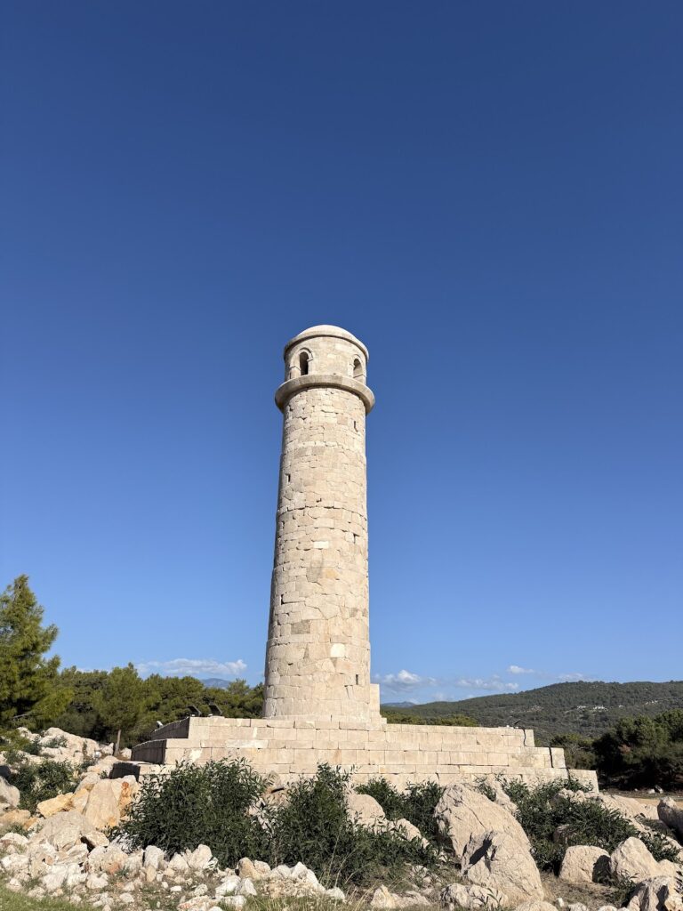
The lighthouse stood at the entrance to the outer harbor. Built in the first century AD, probably around AD 60 under Nero, it was a five-story structure about 20 meters high. A circular tower rose from a square base, and a Greek inscription ran around the tower. The surviving remains consist of the square pedestal and the lowest circular tier. A related outer-harbor lighthouse has not been located.
Granary of Hadrian
Hadrian’s Granary stood on the western side of the harbor and was built around AD 131 in connection with the emperor’s visit. Measuring approximately 75 by 25 meters, it was divided into eight sections and may have had two stories. The stone building contained vaulted interior rooms and was surrounded by smaller commercial structures. It served as a major storage and trading complex for grain and other goods.
Theater and Civic Buildings
Theater
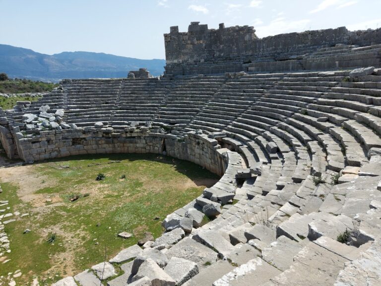
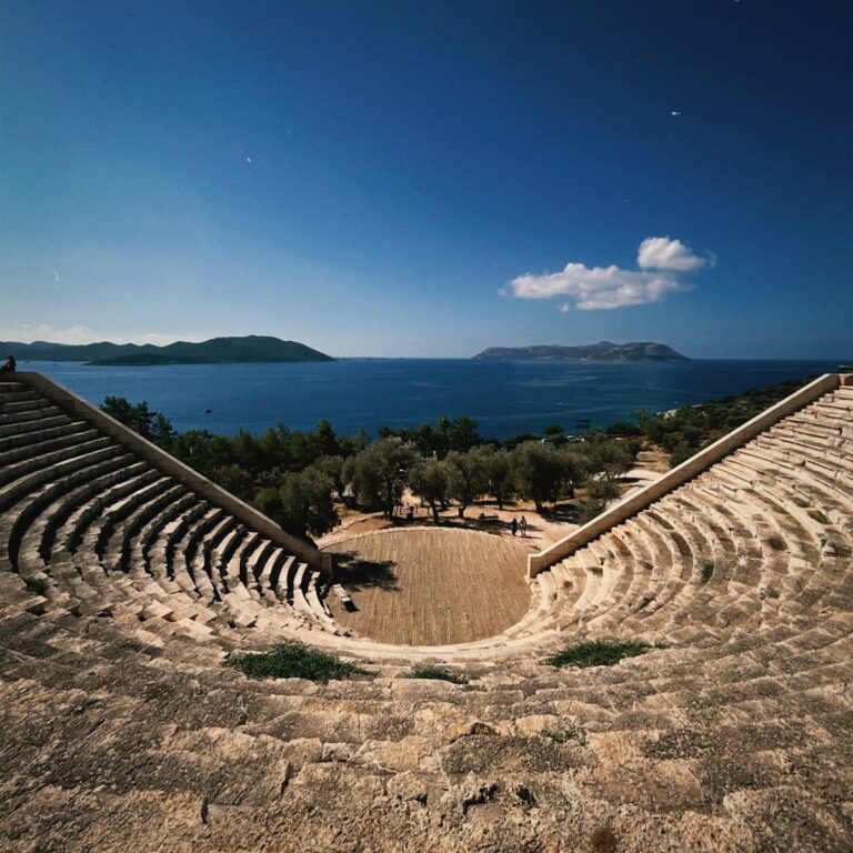
Patara’s large Greek-type theater has a circular orchestra and a seating area extending slightly more than a semicircle. The seating area measured approximately 84 meters in diameter and could accommodate about 6,000 spectators. The lower cavea, or auditorium, had 17 rows divided into eight wedge-shaped sections. The upper cavea had 14 rows divided into sixteen sections, and a broad diazoma, a passage dividing seating tiers, separated the two zones.
The upper seating rested on a vaulted stone gallery rather than directly on the hillside. The gallery supported the seats and provided circulation and evacuation access. Massive side walls supported the theatron, or seating area, while a colonnaded portico once stood above the upper cavea. The orchestra measured about 23 meters across and may also have hosted games.
The stage building was approximately 40 meters long and 4.5 meters wide. Its two-story colonnade faced the orchestra, and five doorways opened onto the stage platform. A three-level outer facade carried pilasters, aedicule niches, and arched windows, with two colonnaded porticoes at the sides. Finely cut limestone blocks formed the theater.
A theater probably existed during the Hellenistic period, but the surviving building was constructed in the first century AD. An inscription credits Polyperchon, a servant of Apollo, with a major contribution during the reign of Tiberius. After the earthquake of AD 143, Quintus Velio Titionus and his daughter Vilia Procula financed major rebuilding, probably in AD 146 or 147 under Antoninus Pius. Eleven rows were added to the upper cavea, the stage building was reconstructed, and marble elements and statues were installed. The theater also acquired a velum, an awning used to shade spectators. Restoration campaigns in the 2000s cleared and conserved the structure.
Bouleuterion
The Bouleuterion lies north of the theater. Its approximately rectangular plan measures about 43 by 29 meters and has a slightly curved western wall. The central hall contained a semicircular theatron with 20 rows of stone seats. Six stairways divided the seats into five sections, and a central seat, probably reserved for the lyciarch, stood within the seating area. The lyciarch was the chief magistrate of the Lycian League.
Five monumental doorways and two side passages led into the hall, which was connected to a narrow vaulted corridor. The building probably had a timber roof and may have had windows above the seating passage. A portico faced the agora to the east. Usually dated to the middle of the first century AD, the Bouleuterion may have replaced an earlier building. It was altered in the second century, probably after the earthquake of the early 140s, and later became part of the city fortifications as a bastion. Its five doorways have also raised the possibility that it served as both a council hall and an odeon, a smaller roofed performance or meeting hall.
Stoa and Roads Monument
A double stoa on the southern quay was repaired after an earthquake in AD 141 or 142 by Opramoas of Rhodiapolis. Its front columns were later incorporated into a Byzantine fort. The Stadiasmus Patarensis, discovered in 1993, is a monumental Roman pillar bearing a Greek inscription dedicated to Claudius. It lists roads, place names, and distances in Lycia and Pamphylia. The pillar is preserved at the Antalya Museum. A related Roman roads monument once stood on the southeastern quay of the inner harbor and may have guided travelers arriving by sea.
Baths and Commercial Buildings
Vespasian’s Baths
At least five bath complexes are known at Patara. Vespasian’s Baths, also associated with Nero, are the largest, measuring about 38 by 27 meters. They contained a frigidarium for cold bathing, a tepidarium for warm bathing, and a caldarium for hot bathing. Marble decoration and wall painting are poorly preserved, while the hypocaust, an underfloor and wall-heating system, survives relatively well.
An inscription associates the complex with Vespasian, although it was probably built during Nero’s reign and repaired or rededicated under Vespasian. The baths were later incorporated into the Byzantine defenses and finally abandoned during the Middle Byzantine period.
Other Bath Complexes
The Harbor Baths stood near the Arch of Mettius Modestus and formerly faced the harbor. Built of limestone in the second century, they were probably used especially by sailors and travelers entering through the harbor district. From around the fifth century to the first half of the seventh, they were converted into a workshop.
The Central Baths, approximately 25 by 19 meters, stood near the end of the colonnaded street and contained bathing rooms and a palaestra. The Small Baths stood west of the principal street and were probably built in the second or third century. The Byzantine Baths formed a small complex beside the Corinthian Temple and the medieval city walls.
Temples, Churches, and Religious Remains
Corinthian Temple
The so-called Corinthian Temple stands in the southeastern part of the medieval city. It was a prostyle sanctuary, meaning that columns stood across its front facade, on an 18-by-12-meter raised platform. Its inner sanctuary measured 7 by 8 meters and had a four-column Corinthian porch. The porch is lost, but the monumental entrance portal survives relatively well.
The temple is generally dated to the second century AD, although its deity is unknown. It was probably closed around the fourth or fifth century, and its remains were incorporated into the medieval fortifications as a tower or bastion.
Sanctuary of Apollo
The location of Patara’s major sanctuary of Apollo and its oracle remains unknown. An oracle was a sanctuary or prophetic institution where divine guidance was sought. A head of Apollo found on Tepecik Hill during excavations in the 1990s suggests that the sanctuary may have stood near the earliest acropolis.
Great Basilica
The Great Basilica stood east of the Harbor Baths. Its approximately 80-by-45-meter complex included a three-aisled basilica with a transept, a baptistery, and a large colonnaded atrium. Built of worked local limestone, it was richly decorated with marble elements and mosaics. The basilica dates to the sixth century and probably housed Patara’s episcopal seat.
A small chapel was added in the northwest corner during the eighth to tenth centuries. The complex was later used as a cemetery. Excavations began in 1993, and the remains are partly displayed.
Other Christian Churches
Another early Christian basilica west of Tepecik Hill is completely submerged and has not yet been investigated. The Necropolis Basilica near Tepecik Hill had an elongated three-aisled plan. Its massive stone piers suggest vaulted and possibly domed roofing, and it is tentatively dated to the eighth through tenth centuries.
A later church within the medieval fortifications had a cross-domed plan with an elongated western section and very narrow side aisles. Six supports carried the vaulting, including two substantial eastern piers and four columns. The church had a western atrium, of which one wall survives, and is dated to the tenth through twelfth centuries or possibly somewhat later.
Necropolises and Tombs
The earliest known burials lie on the slopes of Tepecik Hill and date from the sixth or seventh centuries BC. About 48 to 50 rock-cut tombs are known there. A larger eastern necropolis contains mainly Roman-period burials, including sarcophagi, monumental tombs, temple tombs, exedra tombs, underground-chamber tombs, and altars used in pagan rituals.
Temple Tombs
A large pseudoperipteral temple tomb stood near the granary on the western side of the harbor. This type of building appears to have a surrounding colonnade, although its side columns are attached to the walls. The burial chamber rested on a 19-by-14-meter stone platform reached by a monumental staircase of ten steps. Earthquakes heavily damaged the tomb.
The Tomb of Marcia on the eastern side of the harbor is a third-century BC prostyle temple tomb. Its burial chamber stood on a 14-by-9.5-meter platform. An inscription identifies Marcia Aurelia Chryion as its patron and records the burial of Marcia, her father Alchimos III, a lyciarch, and her husband. The nearby Tomb of Akdam is another third-century BC prostyle temple tomb, with a partly preserved cylindrical vault and a roof that was originally gabled.
Landscape and Cultural Associations
The date-palm grove associated with Leto consists of approximately thirty old date palms beside the Harbor Baths. Local myth connects the grove with the birth of Apollo. The ancient harbor has since become a reed-filled wetland, separated from the sea by a sand-and-dune barrier about 600 meters wide. Its surviving pools and changed shoreline preserve the physical setting of the former port that shaped Patara’s history.