Fort Center: An Indigenous Earthwork Complex in Florida
Site at a Glance
- Popularity
- Medium
- Country
- United States
- Primary era
- Classical
- Eras represented
- Classical, Medieval, Early Modern, Modern
- Civilizations
- Unclassified
- Site type
- Religious
- Remains
- Sanctuary
On this page18 sections
History
Fort Center is an Indigenous archaeological complex in the Fish Eating Creek Wildlife Management Area near Moore Haven, Florida, United States. People of the Belle Glade culture occupied the site from at least about 450 BCE until around 1700 CE, with the earliest phase possibly beginning by 1000 BCE. Its setting belongs to the Lake Okeechobee region, whose relationship to the broader Glades cultural area remains a matter of interpretation. Archaeologists distinguish the Belle Glade and Glades regions from the Caloosahatchee area associated with the Calusa, even though the Calusa later exercised political influence across much of southern Florida.
Early occupation and Period I
Fort Center’s archaeological chronology divides its long occupation into four periods. Period I began before 450 BCE, perhaps as early as 1000 BCE, and lasted until about 200 CE. At a given time, the settlement may have housed only one or a few families. Access to food near Fisheating Creek likely helped make the location attractive, while later construction episodes brought additional people there temporarily.
People relied mainly on fishing, hunting, and gathering. Animal remains point to a varied diet that included turtles, fish, alligators, snakes, frogs, birds, and mammals such as deer, raccoons, and opossums. Maize pollen occurs in deposits associated with the early occupation. Its date and origin have been debated, however, and pollen alone does not establish how widely the crop was grown or eaten.
Period II and the ceremonial center
Period II began around 200 CE and continued until sometime between about 400 and 600 CE. Roughly three to six families were associated with a ceremonial center formed by Mounds A and B and an artificial pond. William H. Sears, the archaeologist whose excavations shaped later study of the site, proposed that specialists there prepared the dead, including by removing flesh from bones. He thought these people and their families first lived on Mound B, then shifted to Mound A while mortuary work continued at Mound B. He also suggested the center provided tobacco, pipes, and lime used in processing maize. The idea that its residents constituted a sacred social class is an interpretation rather than a settled conclusion.
Around 500 CE, the site saw a major episode of secondary burial, in which remains were gathered and bundled after an earlier stage of mortuary treatment. Analysis of human remains from the pond and mound has identified osteoarthritis and anemia associated with parasites and iron deficiency, alongside indications of generally good nourishment. In the studied group, few people lived beyond 35, and none reached about 55.
Maize pollen has informed competing interpretations of the site’s economy and ritual life. Sears viewed the pollen and comparisons with earthworks elsewhere as support for agricultural use of the circles, and proposed that maize may have been a ceremonial or high-status food. Later reassessment confirmed much of his underlying archaeological data, while questions remained about the pollen’s dating and origin. Dental-wear analysis suggests that Period II residents did not depend on horticulture and that maize made little contribution to their everyday diet.
Periods III and IV
Period III began sometime between about 600 and 800 CE and ended between about 1200 and 1400. By this phase, the earlier ceremonial center was no longer active, although occupation continued at Midden A, part of Midden B, and Mound A, at least during the period’s earlier centuries. The recovered objects show relatively little change from those associated with Period II.
Period IV began between about 1200 and 1400 and continued until around 1700. People continued living at Middens A and B, while settlement spread to prairie mounds and associated linear earthworks. Maize pollen appears again in deposits from this phase. Fort Center probably lay within the Calusa realm at the time. Hernando de Escalante Fontaneda, a sixteenth-century Spanish captive in Florida, described the Mayaimi people around Lake Okeechobee as living in small towns and scattered settlements under Calusa authority.
Military use in the nineteenth century
During the Second Seminole War, the U.S. Army built a fortification beside Fisheating Creek at the northeastern edge of the Great Circle. It was named for Lieutenant J. P. Center, killed at the Battle of Lake Okeechobee, and formed part of the supply network around the lake. In 1842, a U.S. Navy reconnaissance party led by Lieutenant John Rodgers occupied the abandoned post for several days and repaired its palisade, a defensive fence made from upright trunks. The party found signs of Seminole residence near the creek but did not encounter Seminoles during its 60-day expedition. The Army reactivated Fort Center during the Third Seminole War of 1853–1855 as a station on the military road between Fort Myers and Fort Jupiter, part of which crossed Lake Okeechobee by canoe.
Archaeological investigation and changing interpretations
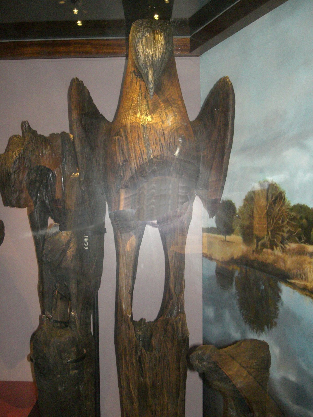
A carved wooden bird found in the pond in 1926 drew archaeological attention to Fort Center. Federal Emergency Relief Administration teams surveyed and tested parts of the site during the 1930s and 1940s, and John Goggin conducted further survey and test excavations in the early 1950s. In 1961, an amateur group excavated beyond the permission granted by the landowner, removing artifacts that included objects made from reworked Spanish metals. The landowner then ended the permit and invited a professional archaeologist to survey the area. Teams from the University of Florida, Colgate University, and Florida Atlantic University excavated the complex from 1966 to 1971.
Sears proposed that migrants from northern South America brought maize, pottery, and earthwork-building traditions to Florida. He drew on similarities among tools, pottery, and earthworks, as well as a proposed connection between Timucuan, an Indigenous language of northern Florida and southern Georgia, and South America. Other archaeologists challenged the migration theory, noting its reliance on limited comparisons and difficulties in matching proposed agricultural movements with evidence from the Caribbean.
In 1999, the State of Florida acquired Fort Center as part of the Fisheating Creek Ecosystem. Further research by Victor D. Thompson and Thomas J. Pluckhahn identified four circles and interpreted the Great Circle as a monumental ritual earthwork. They proposed that the circles were repeatedly destroyed and rebuilt, linking these acts to ideas of death and renewal. Their assessment differed from Sears’s agricultural interpretation, although it confirmed much of his archaeological data. Thompson and Pluckhahn placed Fort Center within a wider regional tradition of enduring monumental ritual landscapes. Later interpretations have emphasized spiritual and conceptual meanings alongside economic explanations, while historian Ted Ehmann proposed that successive groups cooperated at the site and blended cultural and religious practices.
Remains
The archaeological complex extends about one mile (1.6 km) east to west along Fisheating Creek and is roughly half a mile (0.8 km) wide. Its earthworks, mounds, middens, circular ditches, and artificial pond occupy a landscape shaped by the creek, wet prairie, and wooded hammocks. Fisheating Creek flows into Lake Okeechobee, a few miles southeast of the site.
Landscape and settlement areas
The creek’s meander belt includes floodplain swamp and natural levees, raised ground formed beside a stream. Wet prairie surrounds this zone, while hammocks contain oak, cabbage palm, and saw palmetto. Flooding affects both the prairie and floodplain. Prairie soils have a sandy upper layer about two to four feet deep above hardpan, a compact layer that restricts drainage. Pollen evidence indicates that the creek belt and prairie retained broadly similar forms through much of the period of human occupation. Hammock cover expanded after occupation ended around 1700, and twentieth-century land use converted much of the surrounding area to improved pasture.
Mounds and house sites
Creek-side mounds and Midden B
Five round mounds, numbered 10 through 14, lie in or near the creek meander zone. Each measures about 100 feet across and stands two to three feet high; most have become incorporated into natural levees. They may have been raised on existing levees, or may have contributed to the levees’ form. Three burials were found in Mound 13, which may have served first as a burial place and later as a house mound. In Period I, people used part of an old natural levee, Midden B, as a living area. In much of the basin, raised house sites helped keep floors above floodwater; this levee provided locally elevated ground.
Period IV mounds and linear earthworks
Period IV settlement included Middens A and B and Mounds 1, 2, 3, 5, 8, and the University of Florida Mound. Most of these mounds were newly built during this phase. Mound 3 grew from a small natural rise that had already been occupied, while Mound 8 may itself be natural. Broken smoking pipes found at the original ground level beneath the University of Florida Mound suggest possible ceremonial activity before construction of the mound.
Each Period IV mound, apart from the levee settlements, was large enough for one house and was associated with a separate linear earthwork. These raised ridges measure about 30 to 100 feet wide, 300 to 1,200 feet long, and two to three feet above the prairie. Adjacent ditches supplied the soil used to build them. One end of each ridge lies near a house mound, but the two features are not joined.
Circular earthworks
Excavations identified three circular ditches: two partly overlapping circles about 300 feet across, and a later, much larger circle enclosing them without sharing their center. Laser-based ground mapping later revealed a fourth ditch. The outer circle, known as the Great Circle, measures about 1,197 feet (365 metres) across. Its ditch is approximately 25 to 30 feet wide and six feet deep, with most of the excavated soil deposited along its inner edge. Openings lie to the southeast and east; the eastern opening is nearest Mound B.
Maize pollen was found beneath soil disturbed during ditch construction. At least one earlier ditch cut through the hardpan unevenly. Sears interpreted the circles as agricultural features, while later research treated the Great Circle as a monumental ritual earthwork and linked repeated rebuilding to ideas of death and renewal.
Period II ceremonial complex
Enclosing embankment
On the prairie near the creek meander belt, an embankment enclosed Mound B and the pond, joining Mound A at both ends. Part of the enclosed ground forms a courtyard. Its purpose is uncertain.
Mound A
Mound A is irregular in outline and about three feet high, with slightly raised areas that probably mark house locations. Postholes indicate round or oval houses about 30 feet across. Deposits accumulated here include pottery fragments, deer bones, maize pollen, shell tools, stone grinding tools, pipes, human baby teeth, and human bones broken in a manner resembling animal bones. The pattern has been interpreted as possible evidence of cannibalism. Imported pottery fragments include Deptford, Cartersville, Pasco, Crystal River, and St. Johns types; Sears suggested some trade wares were used ceremonially.
Pits in the mound show that shells were burned to make lime. The shells included mainly river mussels, along with conchs and venus clams. Human coprolites, or preserved feces, found near the pits were preserved by exposure to lime. Mound A was enlarged at least twice during Periods II and III, with particularly dense refuse deposits during the first half of Period II. People continued to live there for some time after 1400.
Mound B
Mound B developed into a cone with a steep upper slope and a slightly flattened top. Decayed conch shells and badly deteriorated human bones and teeth lay on its original surface beneath the earliest midden layer. Soil excavated from the neighboring pond formed the mound’s first construction and surrounding embankment. Around 500 CE, soil from a separate borrow pit raised the mound further, and about 150 secondary bundled burials were placed within that addition. Small deposits of material thought to have come from the pond accompanied the burials. Postholes near upper-level graves may mark small shelters built over them.
Artificial pond
The pond is about four to five feet deep, with a nearly flat bottom. It was cut through hardpan so water above that layer could drain into it and keep it filled. Soil eroded from Mound B later partly filled the basin. Excavation recovered bones representing about 150 people, coprolites, and wooden objects. Some pieces of wood were carved into bird and animal figures, including the bird found in 1926; traces of a lime-based coating survive on some carvings. Long wooden pieces may have supported carvings above the water. Some wood was charred, and Sears proposed that a wooden platform for bundled bodies and carved figures burned and collapsed around 500 CE.
Beneath the wood and bones lay a refuse layer containing pottery fragments, shells, pipe fragments, and coprolites. Sears interpreted this material as waste from a cleanup of Mound A and the pond, and understood the pond as a mortuary feature that may have held the wooden platform. The coprolites included evidence associated with both constipation and diarrhea.
Nineteenth-century fortification
The Army fort stood beside Fisheating Creek at the northeastern edge of the Great Circle. Its palisade was made from cabbage-palm trunks. The position of this military structure placed it beside the much older earthwork complex, although the fort served a separate nineteenth-century military purpose.