Arkaim: A Fortified Bronze Age Settlement Complex in Russia
Site at a Glance
- Popularity
- Very High
- Country
- Russia
- Primary era
- Bronze Age
- Eras represented
- Bronze Age, Classical
- Civilizations
- Unclassified
- Site type
- Military
- Remains
- Fortified Town
On this page13 sections
History
Arkaim is a fortified settlement, cemetery and related archaeological complex in Chelyabinsk Oblast, Russia, associated with the Sintashta culture, a Bronze Age culture of the southern Urals and neighbouring steppe. The settlement is generally dated to the early or middle second millennium BCE, although its precise construction and occupation dates are unsettled. It formed part of the group of fortified sites now called the Land of Towns, a modern archaeological label rather than the name of an ancient state.
Sintashta society and the settlement
Archaeological sites across the surrounding valley span a much longer period, from about 4000 to 1600 BCE. The Land of Towns includes roughly 20 similarly planned settlements in the southern Urals and northern Kazakhstan. Most are dated to around 1800–1600 BCE, though one has been placed earlier.
Genetic research has found substantial similarities between Sintashta people and communities associated with the Corded Ware culture, a prehistoric European culture known in part for cord-patterned pottery. Migration east from Corded Ware regions may have contributed to Sintashta’s formation. The language and ethnic identity of Arkaim’s inhabitants cannot be established conclusively. The prevailing interpretation is that they spoke Proto-Indo-Iranian, the reconstructed ancestor of Indo-Aryan and Iranian languages.
People at the settlement grew crops that included millet, barley and onions, and kept animals for meat and milk. Some herders lived beyond the settlement, tending animals or cultivating land, and returned during winter or when danger arose. Residents cast bronze by combining copper and tin, producing objects for local use and longer-distance exchange. They also made items from pottery, stone, bone and wood. Environmental evidence points to a warmer, wetter interval than today, with pine woodland, ferns, spruce and alder in the area; soil studies suggest this favourable period did not last long.
Arkaim’s purpose remains debated. Proposed explanations include a defended community or refuge, and a centre for metalworking, exchange or religious activity. Its organized defenses have also been interpreted as evidence that residents could coordinate major communal building work. One interpretation holds that the settlement was occupied for about two centuries before a fire and abandonment, rather than a conquest. The apparent removal of possessions has been used to support this account.
Rediscovery and protection
The name Arkaim comes from a hill about four kilometres south of the settlement, not from the nearer village of Alexandrovsky. It derives from a Turkic word meaning ridge, back or base. The area had appeared in photographs taken in 1952, and the settlement was noted again in 1974–75. Systematic investigation began in 1987, when archaeologists surveyed the valley ahead of a reservoir project intended to supply an irrigation system. On 20 June, student volunteers Aleksandr Voronkov and Aleksandr Ezril noticed unusual earthworks. Archaeologists S. G. Botalov and V. S. Mosin assessed the site, and Gennady Zdanovich announced the discovery.
The planned reservoir threatened to flood the remains. Advocacy by State Hermitage Museum director Boris Piotrovsky, Georgy Mesyats of the Urals Branch of the Soviet Academy of Sciences and other specialists helped win a two-year delay. A research laboratory for the ancient civilization of Chelyabinsk Oblast was established in 1989, and investigations continued through the 1980s and 1990s with Zdanovich, Botalov, Mosin, S. A. Grigoriev and D. G. Zdanovich. Arkaim became a protected cultural area in 1991. In April 1992, the Russian Council of Ministers cancelled the reservoir and set aside 3,300 hectares for a nature and archaeological reserve affiliated with the Ilmensky State Reserve. Arkaim is recognized as an archaeological monument and a cultural heritage property of federal significance.
Modern reinterpretations
From the 1990s onward, esoteric, nationalist and neopagan movements adopted Arkaim as a sacred place. Some promoted it as an Aryan or Slavic capital, a source of hidden knowledge or energy, an observatory, or the birthplace of Zoroaster. These claims are not supported by archaeological evidence. In historical scholarship, Aryan refers to ancient Indo-Iranian peoples, not to Slavs or all Indo-European peoples. The site’s adoption as a sacred place has been associated with a substantial reduction in scientific fieldwork.
Astrologer Tamara Globa’s visit in 1991 helped initiate esoteric interest. By 2005, a large swastika had been laid out on a nearby hill, and the nationalist National Aryan Union was active at Arkaim. Satirist Mikhail Zadornov helped circulate Aryan interpretations and, in 2008, released a film about the site with writer Sergey Alekseyev and director Alexander Volkov. Some bodies associated with the Russian Orthodox Church have criticized activities connected with Arkaim’s archaeology.
Remains
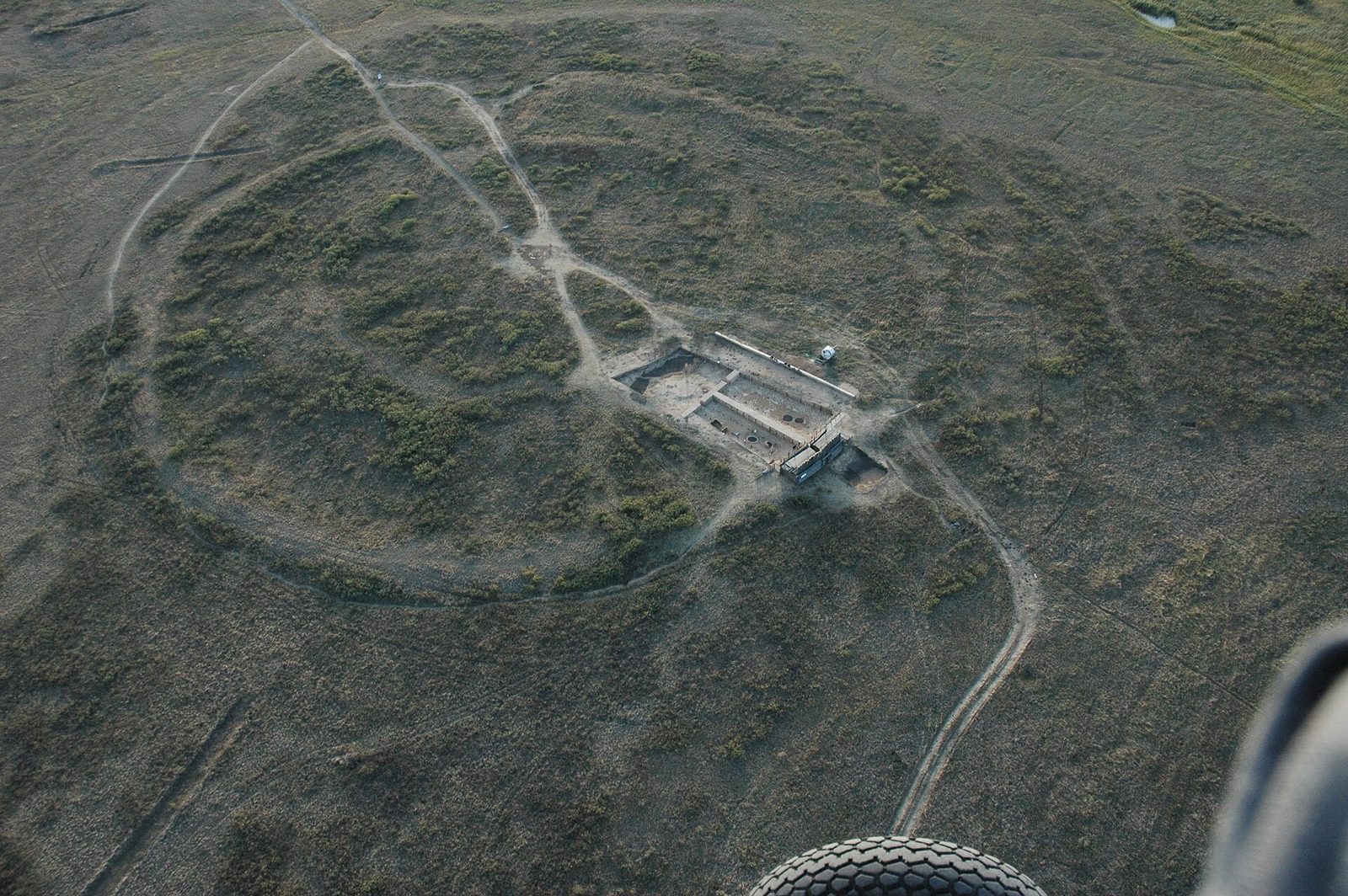
The complex occupies raised ground between the Bolshaya Karaganka River and its tributary, the Utyaganka, in the southern Ural steppe. Within the protected area, the fortified settlement has a roughly circular plan, with two defensive rings around groups of houses and a central open space. The Bolshekaragansky cemetery lies about one to one and a half kilometres northeast, on the Bolshaya Karaganka’s left bank.
The fortified settlement and its surroundings
Defensive rings and entrances
The outer defensive ring measures about 150 metres across, while the inner one is roughly 85 metres across. Estimates place the walls at four to six metres in both thickness and height. The outer wall used timber framing, unfired clay bricks and packed clay. Its base included turf and stones set into a trench to support the timber structure; bricks, joined with clay mortar, formed the outer face, and packed clay filled the core. A water-filled moat about 1.5–2.5 metres deep surrounded the outer wall.
Four built passages faced the cardinal directions, with the principal entrance on the west. One proposed defensive reconstruction suggests that a wooden bridge could be raised across a pit about three metres deep on the inner street, leaving attackers exposed to people on house roofs. This is a suggested reconstruction of how the entrance might have worked.
Houses, street and water systems
Roughly 60 trapezoidal houses stood in inner and outer groups, sharing long walls and covering about 110–180 square metres each. One count gives 39–40 dwellings in the outer group and 27 in the inner. The outer houses opened onto a circular street; doors of the inner houses faced the central open area, measured at about 25 metres across, or in one estimate 25 by 27 metres. Some descriptions give the house rings diameters of about 39–40 metres and 27 metres.
Inside the houses, narrow corridors, niches and passageways connected areas with hearths, ovens, wells and storage pits or cellars. Traces of metalworking have also been found. About a third of a house’s floor area has been interpreted as space for household or work activities. Upper floors are considered possible; some reconstructions propose ladders between levels and roof runoff collected in two or three pits per dwelling.
A wooden-paved circular street ran between the house groups. Beneath it, a drainage channel about 1.5 metres wide and deep included wells for collecting water. A separate proposed system may have directed rainwater from roofs through wooden pipes and successive wells for cleaning.
Nearby cultivated land
Small plots lay outside the settlement and across the surrounding landscape. One measured group of fields was about 130–140 metres by 45 metres. Canals and ditches brought irrigation water from nearby rivers.
The Bolshekaragansky cemetery
Mounds and burial spaces
The cemetery’s burial mounds covered platforms edged by ditches and separated by earthen ridges. Platforms held between seven and 20 burial or offering pits. One described circular enclosure was about 19 metres in diameter, with a surrounding ditch interrupted at crossing points, possibly 12 in all; wooden posts stood beside at least one crossing. Thirteen pit-like depressions inside the enclosure contained remains of chambers. The cemetery was used over several decades and held 28 or 29 people in individual, paired and group burials.
Graves, offerings and human remains
Grave pits reached about 3.5 metres deep and could contain chambers on up to three levels, separated by wooden floors or decking. People were usually placed on their left or right side with limbs drawn in. Animal remains, including horses, cattle, sheep or goats, and dogs, appeared in upper chambers and have been interpreted as offerings. Other grave goods include pottery vessels, wooden cups, copper and bronze knives, spear and arrow points, and objects made of stone, bone and wood.
One unusual burial contained the embracing remains of a man and woman, with the woman holding a battle axe above the man’s head. Interpretations of the curled burial positions include the possibility that they expressed rebirth after death or death as sleep. Estimates place average height at about 172 centimetres for men and 168 for women, and average age at death at 30–35 years, partly attributed to high child mortality; some people lived to about 60. Human remains also indicate a diet of plant and animal foods and relatively little tooth decay. Burial mounds assigned to the later Sarmatian culture, associated with Iranian-speaking peoples of the Eurasian steppe, lay beside the Bronze Age cemetery mounds.
Interpretations of the settlement plan
Some researchers interpret Arkaim’s circular plan as a model of the cosmos described in Indo-Iranian religious traditions and connect it with Yima, a legendary ruler in Iranian tradition, or the related Vedic figure Yama. They have also identified swastika-like patterns in foundations and houses of the second ring, as well as on objects from the site. These remain proposed meanings rather than established explanations of the plan. Archaeologist Konstantin Bistrushkin has argued that geometric alignments made Arkaim an observatory, identifying 30 seasonal sky events, including 12 lunar and six solar events, and claiming a precision of one arcminute, or one-sixtieth of a degree. This astronomical interpretation remains disputed.