La Venta: An Olmec Civic and Ceremonial Center
Site at a Glance
- Popularity
- Very High
- Country
- Mexico
- Primary era
- Iron Age
- Eras represented
- Iron Age, Classical
- Civilizations
- Olmec
- Site type
- City
On this page19 sections
History
La Venta was an Olmec civic and ceremonial center in present-day Tabasco, Mexico. The Olmec were an early civilization of Mexico’s Gulf lowlands, within Mesoamerica, the cultural region of present-day Mexico and Central America. Occupation in the area reaches back to about 1750 BCE, while La Venta’s principal urban and ceremonial development took place approximately between 1200 and 400 BCE. The center became prominent after the decline of San Lorenzo, around or after 900 BCE, and flourished during the centuries from about 900 to 400 BCE.
Growth and regional influence
At its height, La Venta’s population is estimated to have reached at least 18,000. Religious, political, and economic authority was concentrated there in a society with an elite, skilled specialists and craftspeople, and a much larger workforce of farmers and laborers. La Venta may have influenced communities between the Coatzacoalcos and Mezcalapa rivers. Its economy included tribute and the management of trade in luxury goods, as well as the acquisition of materials such as jadeite, serpentine, basalt, feathers, and hides. Cacao may also have formed part of exchange.
Fertile floodplain soils and abundant wildlife and aquatic resources supported farming and food gathering in the surrounding region. Finds from settlements along the former Palma River include maize, beans, squash, and remains of deer, dogs, crocodiles, fish, turtles, and mollusks. Periodic floods replenished the soil and could allow as many as three harvests in a year. Olmec communities are also credited with cultivating cacao in Mexico and preparing a drink from ground beans mixed with water, spices, herbs, and chili peppers. It was associated with religious rites or medicinal use, though its preparation is not firmly established.
Residents gathered naturally occurring asphalt, locally called chapopote, from deposits on land, water surfaces, and the coast. They used it as an ornament and adhesive, to seal basalt water channels and boats, and to decorate figurines and knife handles. It also served as a floor coating, and may have been applied to walls or roofs.
Decline and abandonment
La Venta seems to have been largely abandoned by about 400 BCE. Changes in the environment, including shifts in river courses, have been proposed as causes of decline. The resulting disruption across the region may have encouraged large-scale migration. La Venta’s decline is understood as part of the end of Olmec prominence, although Olmec-related cultural activity continued later at places such as Tres Zapotes. Proposed links between migrating Olmec groups and the formation of later peoples, including the Maya, remain uncertain.
Archaeology and modern disturbance
Frans Blom and Oliver La Farge recorded the central area during an expedition in 1925, producing an early plan that informed later work. The site was initially thought to be Maya. Improved radiocarbon dating in the 1950s helped establish that Olmec centers predated the earliest Maya settlements. Matthew Stirling and Philip Drucker led the first excavations, from 1940 to 1943. Their work uncovered major sculptures, altars, tombs, and the serpentine mosaics; Stirling reported finding 32 sculptures. His research helped place Olmec culture in its archaeological context.
Robert Heizer, Drucker, and their collaborators investigated La Venta in 1955. Drucker focused on Complex A, documenting layers of construction and examining its development. Heizer identified an airstrip crossing the archaeological area, where remains had been disturbed. From 1967 to 1969, Heizer and colleagues surveyed the pyramid, parts of Complexes A and B, the Stirling Acropolis, and buildings to its south. A 1968 plan plotted 46 sculptures, including some whose original locations had become uncertain after removal to Villahermosa. A magnetic survey in 1967 also detected an unexplained signal on the pyramid’s southern side.
Archaeologist Rebecca González-Lauck led excavations for Mexico’s National Institute of Anthropology and History from 1980. Surveys in 1984 and 1985 added to knowledge of the site and identified residential areas, mainly in the north. Work in the 1980s also mapped La Venta and established programs of research, protection, and restoration.
Construction and urban growth severely affected the ancient settlement, especially between 1950 and 1985. A petrochemical complex built in the south during the 1950s destroyed a large area. An airstrip and later a road crossed archaeological remains near Complex A and the findspot of Monuments 2, 3, and 4. Construction of a school destroyed two platforms between buildings D-1 and B-3. Unregulated removal of sculptures and expanding settlement also damaged archaeological contexts. A boundary drawn in 1970 enclosed the principal, or nuclear, area; by 1980–90, more than 230 families lived on its periphery, where remains were also affected. Of the ancient city’s estimated 200 hectares, later assessments considered only slightly more than 100 hectares sufficiently preserved from destruction.
An archaeological rescue project in 1958 and 1959 recorded two additional sculptures. To protect monuments from destruction and looting, 35 were transferred to Parque Museo La Venta in Villahermosa by the poet Carlos Pellicer Cámara; other monuments are held at the Carlos Pellicer Cámara Regional Museum. On 11 January 2009, 23 ancient Olmec sculptures were damaged with a mixture of salt water, grape juice, and oil during an attempted ritual. The incident led Mexican legislators to draft proposed measures to increase penalties for vandalism and looting at archaeological sites.
Remains
Overall plan and construction
The ancient city covered an estimated 200 hectares on a natural rise within an island of about 5.2 square kilometres, surrounded by low, flood-prone coastal land roughly 15 kilometres from the Gulf of Mexico. The Río Tonalá now runs about four kilometres away and may once have been closer. The former or once-active Río Palma, together with the Chicozapote, Palma, and Blasillo rivers, shaped the area; abandoned channels mark changes in their courses. La Venta’s central buildings followed a north–south arrangement. The site is described as oriented about eight degrees west of north, while the centerline of Complex A lay close to true north. An irregular rectangular plaza formed the central group, with a principal pyramid near its middle and mounds and monuments to the north and south. Thirty-two visible mounds were once parts of architectural groups. Most buildings were made of earth or clay, often mixed with sand, as suitable stone was scarce locally. Platforms may have carried walls of branches coated with mud and roofs of palm, or other wooden structures. Basalt brought from the Tuxtla Mountains was used for sculpture, columns, altars, and upright carved monuments; columns in Complex A are also attributed to the Punta Roca Partida quarry on the Gulf coast.
Central architectural groups
Complex A
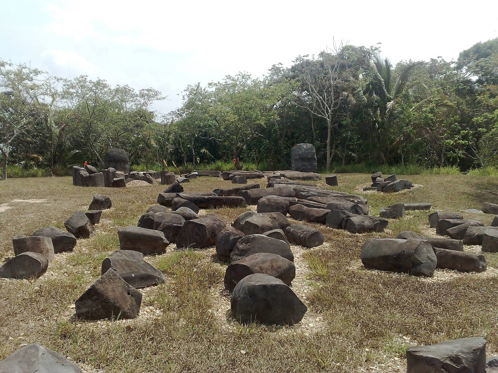
North of the Great Pyramid, Complex A covered about two hectares and was constructed in four phases, approximately between 1000 and 600 BCE. It served as a restricted ceremonial precinct and may also have been associated with the burial of deceased rulers. The group included two plazas, a patio beside Complex C, and nine compacted-earth platforms arranged toward the west. Low platforms and stairways created carefully balanced spaces. Closely set, single-block basalt columns formed a boundary around the most sacred area, with column-enclosed spaces between the plazas. The southern patio contained platforms A-3, A-4, and A-5. A-4 and A-5 were parallel rectangles, each more than 85 metres long, 16 metres wide, and over two metres high. At the patio’s northern end, A-3 measured 32 by 24 metres and stood more than two metres high. A basalt-column barrier bounded the northern patio, which contained three platforms.
Five tombs and numerous offerings were found in the complex. A tomb in building A-2, made with basalt columns, held the remains of two young people, red cinnabar pigment, and jade objects. Other finds from the platform included poorly preserved bones, figurines, masks, and polished obsidian mirrors. A formal tomb contained a sandstone coffin carved with a figure resembling a crocodilian earth being. The complex also yielded more than 30 offerings, around 3,000 objects such as figurines, jewelry, chisels, and axes, and 15 stone sculptures. More than 50 separate caches have been identified, alongside five large deposits of deliberately arranged serpentine blocks.
Two large buried deposits of serpentine blocks lay beneath adobe mounds several metres below the surface. An overlying platform, about two metres high, carried 28 rows of worked serpentine and supported a mosaic of roughly 500 blocks. One deposit, called Massive Offering 3, has been estimated to contain about 50 tons of finished blocks beneath roughly 4,000 tons of clay fill. Offering 4 included 16 jade and serpentine figures. Construction phases also involved removing an earlier clay boundary, enlarging and resurfacing buildings with differently coloured clay, adding platforms, and placing further offerings.
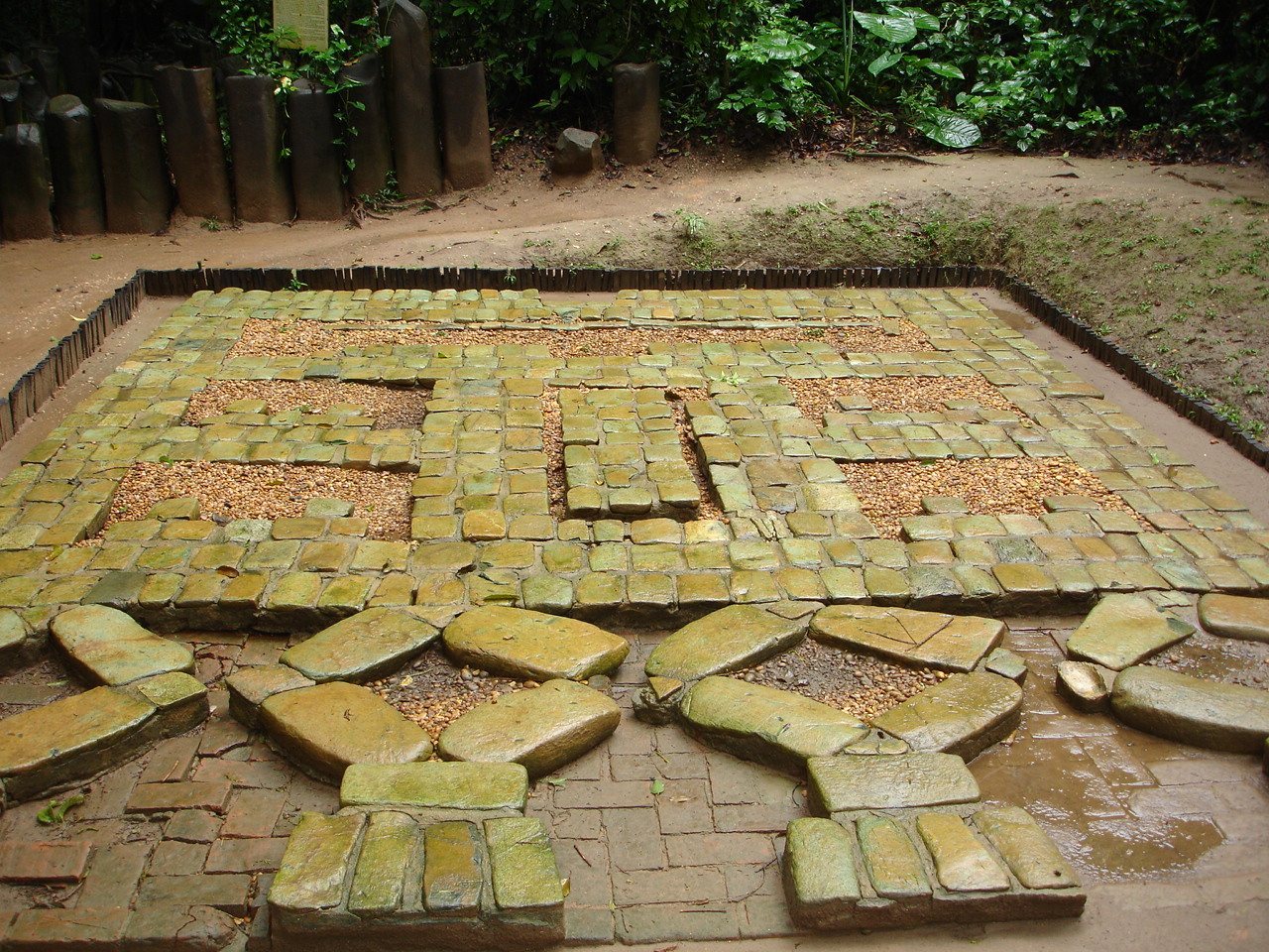
Three rectangular serpentine mosaics, also called pavements, were found at Complex A. Each measured about five by six metres and consisted of 485 horizontally arranged blocks. They were covered soon after completion with coloured clay and earth. Their designs have been interpreted in different ways, including as a jaguar mask, an image of Tlaloc, a broader Olmec motif, a cosmogram, or a symbolic map of La Venta and its surroundings. Monument 19, a relief sculpture from the complex, is considered the earliest known Mesoamerican example of the feathered serpent, a religious figure and artistic motif in several Mesoamerican traditions.
Complex B
South of the Great Pyramid, Complex B included a public plaza exceeding four hectares, nearly 400 metres long and about 100 metres wide. A small platform stood near its centre, and other platforms surrounded the open space. The plaza lay east of Complex B’s platforms and west of the Stirling Acropolis. This arrangement has prompted the suggestion that platforms served as stages for ritual performances watched by people in the plaza, perhaps alongside nearby altars, monuments, and upright carved stones. Replicas of Altars 4 and 5 are displayed in this area.
Stirling Acropolis
The Stirling Acropolis is an irregular, five-sided earthen platform more than 300 metres across, sloping from west to east. It adjoins Complex C to the north, Complex B to the west, and Complex D to the south. Four smaller structures occupy its upper surface. Circular structures AS-1 and AS-2 stand at the southwest end, while parallel rectangular structures AS-3 and AS-4 lie nearer the centre, with AS-3 the larger. Nine monuments and sculptures were found on the platform. Stone water channels and sculptural fragments suggest possible water management and sculpture-making activity. Four small mounds, including buildings B-1, B-2, and B-3, stand near the plaza.
Complex C and the Great Pyramid
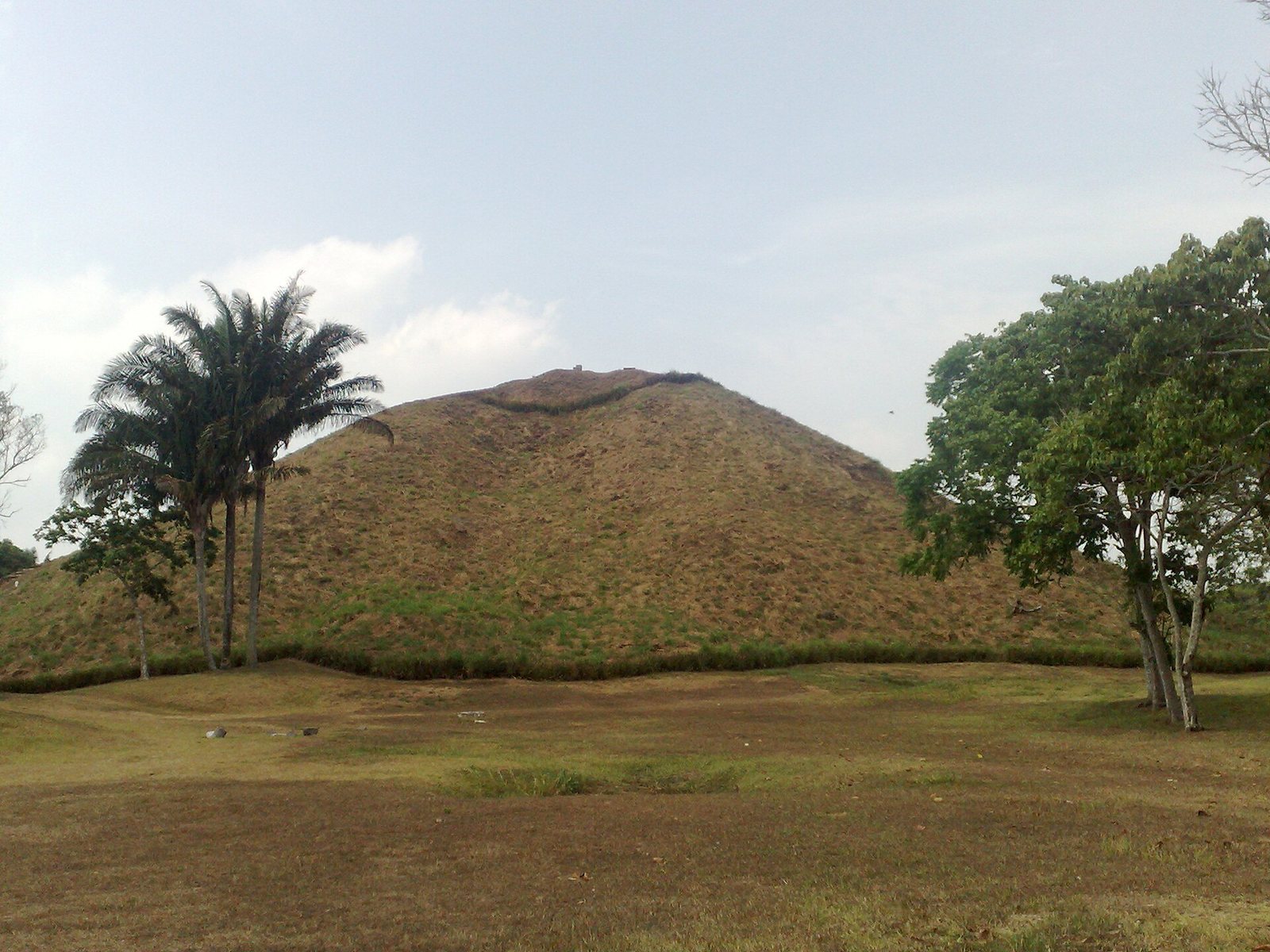
The Great Pyramid, a large clay mound near the city’s centre, is about 128 metres in diameter and 30 metres high, with an estimated 100,000 cubic metres of earth fill. Ten indentations and ten projections give its surface an uneven outline. A later reconstruction proposes that it began as a rectangular stepped pyramid with inset corners and that erosion produced its present rounded, cone-like shape. A burned area on the surface of Structure C-1 yielded a radiocarbon date of 394 ± 30 BCE.
Six low-relief sculptures of supernatural beings were found on the pyramid’s southern side: Monuments 25/26, 27, 87, 88, and 89, as well as Stela 5, an upright carved stone monument. Monuments 25/26 and 27 and Stela 5 lay east of a possible central stairway; Monuments 87, 88, and 89 lay west of it. These works are now displayed in the site museum. Excavation on the south side has indicated a possible central stairway. A magnetic survey also detected an anomaly high on that side; suggested explanations include burnt clay, buried offerings, or a tomb.
Complex D and Building D-7
Complex D consists of more than 20 earthen platforms arranged along three north–south lines. Two sculpted basalt altars are associated with the sides of building D-8. Three monumental sandstone figures of supernatural beings from building D-7 are displayed at the entrance to the site museum.
Building D-7 has a U-shaped plan that opens to the north and may have enclosed an interior space. Its three sloping sides rise about 3.5 metres, while the north side forms a continuous ramp to the upper level; a shallow depression occupies the centre. Monuments 52, 53, and 54 were found on its surface. Monument 53 lay at the southeast corner, 52 at the southwest, and 54 at the northwest. The first and third were face down, while 52 rested almost on its side. Their likely facing directions are southeast, southwest, and north, though these orientations are uncertain. Excavations around the sculptures took place in 1987.
Outer complexes and residential evidence
Complexes E–I
Five further architectural groups lie outside the defined archaeological area. Complex E, north of Complex A, comprises three small earthen platforms. Complex F, farther north and northwest of E, has four rectangular clay platforms. Complex G, northeast of the Great Pyramid, consists of two rectangular platforms; later alteration erased other structures presumed to have stood northwest of them. West of Complex D, Complex H consists of two large, isolated earthen platforms surrounded by modern settlement. Complex I is a clay platform northwest of Complex A, across a local road, and is also surrounded by settlement.
Residential areas and burials
Residential areas have been identified mainly in the northern part of the ancient city. Soil phosphate concentrations at Complex E have also been interpreted as possible evidence of a residential zone. Urn burials there contained bone and tooth fragments in clay pots. One large urn was set in clean yellow sand and covered by an inverted, orange, fine-paste bowl with flaring sides. The bowl’s interior was painted red, and its inner rim carried an incised pattern of paired broken lines.
Stone monuments and archaeological finds
Colossal heads
Four of the 17 known Olmec colossal heads came from La Venta and are designated Monuments 1–4. Monument 1 was discovered in 1926. Monuments 2, 3, and 4 were found in an irregular north-facing row north of Complex A; their precise association with a building is uncertain because the area was disturbed by an airstrip and road. All four were carved from basalt, brought from Cerro Cintepec in the Tuxtla Mountains, more than 80 kilometres away. Their carving is generally dated to about 700 BCE, with a possible date as early as 850 BCE.
Monument 1 measures 2.41 metres high and weighs 24 tonnes. Monument 2, the smallest of heads 2–4, stands 1.63 metres high and weighs 11.8 tonnes; it is heavily eroded and was moved to the Carlos Pellicer Cámara Regional Museum for protection from exposure. Monument 3 is 1.10 metres high and weighs 12.8 tonnes, and is also eroded. Monument 4 stands 2.26 metres high, weighs 19.40 tonnes, and has the largest recorded circumference among the Olmec heads, at 6.53 metres. The heads vary in size, facial features, and headgear. Each has a different form of ear ornament. Monuments 2 and 4 retain identifiable headgear markings, including a possible three-fingered claw on 4. Monument 4 may once have had a surface coating. Their slightly open lips reveal the front teeth. The headgear has been compared to protective helmets, but its function is uncertain.
Basalt altars
At least seven large carved basalt altars are known at La Venta. They are commonly interpreted as thrones used by rulers during important ceremonies. Altars 4 and 5 were found facing each other in Complex B. Altar 4 measures 1.94 metres high, 3.18 metres wide, and 1.69 metres thick, and weighs 30.57 tonnes. Its central figure, possibly a ritual specialist, sits within what appears to be a cave or a creature’s mouth and holds a rope wrapped around the stone. One side is eroded; the other preserves a related scene with a figure and rope. Altar 5 measures 1.58 by 2.08 by 1.86 metres and weighs 16.87 tonnes. Its central figure holds an inert, perhaps dead, were-jaguar baby, an Olmec human-jaguar hybrid. Five low-relief figures on the left side show people holding similar babies; the right side is damaged. Suggested interpretations of the imagery include child sacrifice, a creation myth, or a spiritual journey.
Altars 2 and 3 were found near the Great Pyramid, aligned east to west. Altar 2 measures 1.25 by 1.46 by 1.18 metres and weighs 4.98 tonnes. Its seated figure emerges from a niche holding a child horizontally. Altar 3 measures 1.64 by 1.66 by 1.76 metres and weighs 12.42 tonnes. A seated central figure emerges from a niche, with carved figures on both sides, including two seated figures facing each other on the right. The greater size of Altar 3 has been interpreted as possibly reflecting a more important event. Altars 2–5 are basalt and considerably eroded.
Other sculptures and stone objects
The site’s stone inventory includes 92 recorded pieces, among them colossal heads, altars, upright carved stones, and other sculptures. In addition to the large monuments, finds include a tomb built from basalt columns, four unworked columns that may have served as architectural elements, three stone cylinders, part of a water channel, a step fragment, and five large irregular blocks that may have been intended for carving. More than 3,000 other objects, including figurines, jewelry, axes, and chisels, have been found; many are displayed in the site museum. The museum also contains models, photographs, and more than 200 excavated objects used to explain Olmec organization, beliefs, and everyday life.