Tamarindito: A Maya City in Guatemala’s Petexbatún Region
Site at a Glance
- Popularity
- Medium
- Country
- Guatemala
- Primary era
- Classical
- Eras represented
- Classical
- Civilizations
- Maya
- Site type
- City
On this page24 sections
History
Tamarindito was a Maya city in the Petexbatún region of southwestern Petén, near Sayaxché, Guatemala. It developed into a small center during the Early Classic period, one of the archaeological periods used to describe Maya history. Its rulers later held regional authority, and the city became closely involved in political struggles with Dos Pilas.
Early settlement and royal tradition
People settled the Petexbatún region between about 2000 and 1000 BC. During the Preclassic, an earlier period of Maya history, communities moved from lower ground onto the escarpment as agricultural resources near their villages were exhausted. Tamarindito grew on the higher terrain into a small Early Classic center, despite a substantial rise in population. Its royal dynasty traced its ancestry to the Preclassic, although the dynasty itself is dated to the first or second century AD.
The city’s ancient name is tentatively read as Yahx O’mu’l Nal, translated as “green place where foam abounds.” Part of the reading remains undeciphered. A foundation tradition named the mythical being Min-Mo-Ek’, glossed as “Square-Nosed Beast-Parrot-Star,” as the kingdom’s founder and said he ruled in 3114 BC. Later, Aj Ihk’ Wolok claimed to be the twenty-fifth ruler in succession. Epigrapher Sven Gronemeyer has argued that this count depends on a fictional dynastic founder.
Tamarindito was among the earliest centers established in the Pasión River region, alongside Altar de Sacrificios and Tres Islas. By the fifth century it had become the region’s dominant political power. In the seventh century it served as a capital, with Arroyo de Piedra as a secondary capital. The two centers belonged to the same polity, meaning an organized political community, and shared an emblem glyph, a hieroglyphic identifier associated with a kingdom and its rulers. Tamarindito was the first center in Petexbatún to use its own emblem glyph, a mark of prestige in Maya society and wider Mesoamerican trade.
Rulers, monuments, and regional power
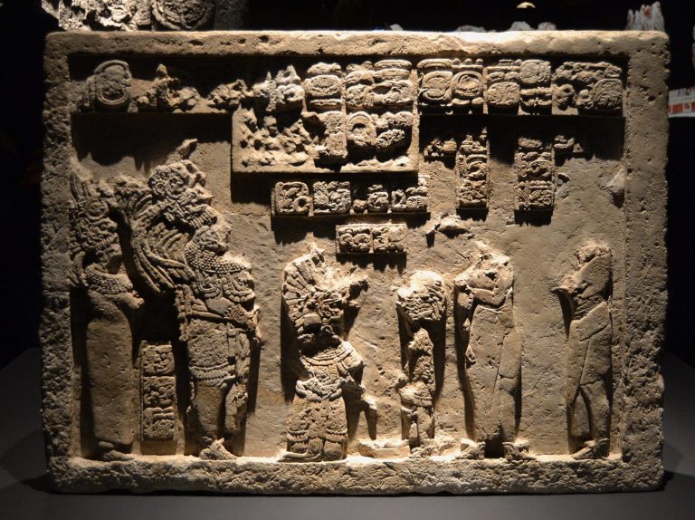
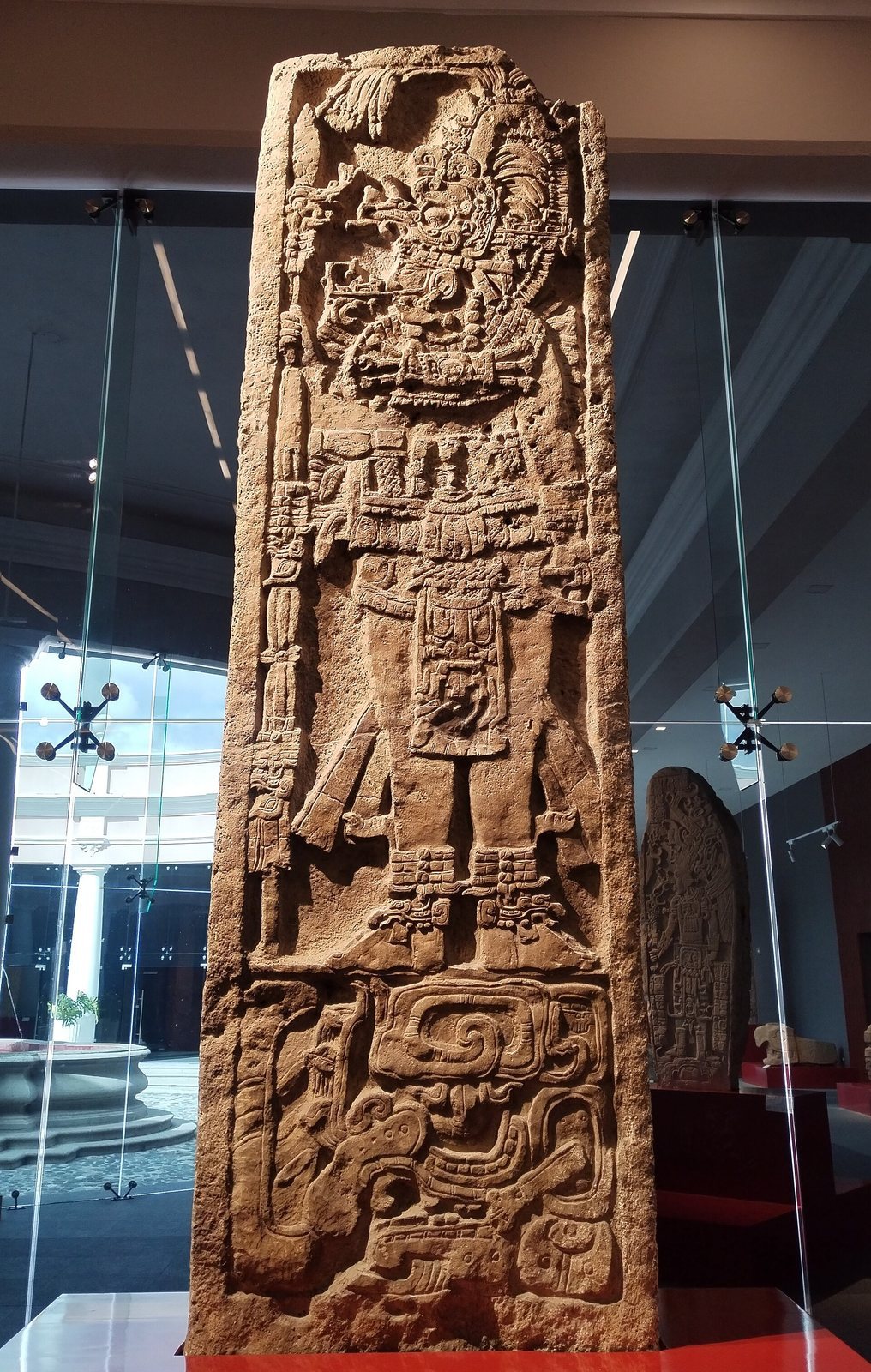
Ruler 1 was born on 23 December 472 and commissioned Stela 5, an upright stone monument, to mark a period-ending date on 21 October 513. Such dates marked the completion of calendrical cycles. His successor, Wakoh K’inich, commemorated period endings on Stela 2 on 3 July 534 and Stela 4 on 20 March 554. Stela 2 associates the 534 commemoration with Yahx Ehb’ Ixik, a title of Ix Ch’ajan Mut, queen of Tikal. The reference may indicate that she visited Tamarindito.
A fragmentary monument set up at Arroyo de Piedra on 5 December 573 identifies Wakoh K’inich of Tamarindito as a father. In 613, probably Tamarindito’s ruler Wakoh Chan K’inich commissioned Stela 1 at Arroyo de Piedra. The two centers wielded political, social, economic, and religious influence in the region during the early Late Classic, another archaeological period of Maya history.
Tikal established Dos Pilas around 632, probably to control the important trade route along the Pasión River. The new center displaced Tamarindito as the regional capital. An inscription at Arroyo de Piedra describes its ruler Chak Bin Ahk as subordinate to Dos Pilas. Tamarindito had close ties to Tikal, Dos Pilas’s rival, and this relationship may have contributed to the cities’ hostility. By the late seventh and early eighth centuries, Tamarindito may also have supplied much of its agricultural production as tribute to Dos Pilas, which produced little food of its own.
War, dynastic change, and decline
In the eighth century, dynastic marriages brought several small allied territories, including Chakha, into Tamarindito’s orbit. Its rulers maintained longstanding friendly relations with the Mutul kingdom, although conflicts eventually involved the Kanul and South Mutul kingdoms. In the 710s, Itzamnaah-K’awiil of South Mutul defeated Aj Ihk’ Wolok. Aj Ihk’ Wolok died, and his dynasty was overthrown. A collateral royal line with roots in Chakha took power, and its ruler Mo-Balam moved the kingdom’s capital to Arroyo de Piedra. Tamarindito nevertheless reached its greatest population during the eighth century.
Chanal Balam became king in 760 and briefly returned the royal residence to Tamarindito. On 26 January 761, Tamarindito and its allies defeated Dos Pilas. Chanal Balam either captured K’awiil Chan K’inich, Dos Pilas’s last king, or sent him into exile. The defeat left Dos Pilas largely abandoned and destabilized the wider region, where warfare intensified.
Within fifty years of the victory, Tamarindito’s population had fallen by almost 80 percent. Some inhabitants may have moved to Punta de Chimino. An inscription at Aguateca dated to 790 mentions a ruler from Tamarindito, though the relationship between the two places at that time is unclear. By the Terminal Classic, the later part of the Classic era, warfare had spread across Petexbatún and its major cities lay in ruins. Many Tamarindito residential groups were abandoned; occupation persisted in only a minority of the investigated groups east of the city center.
By the ninth century, Tamarindito had contracted to a hamlet of a few households near the springs. This may have followed a return to the site after the period of warfare and regional population decline. The city was abandoned after 830, although people continued to live on its outskirts. Some inhabitants may have left for Punta de Chimino during the 810s.
Archaeology and preservation
Tamarindito was declared a National Prehispanic Monument in 1970. Looting took place during the 1970s, and in 1982 people caught looting Structure 44 were briefly imprisoned. Trenches cut into pyramid summits, and parts of a hieroglyphic stairway were taken to private collections in Guatemala City. Looting had diminished by the 1990s, when guerrilla detachments were nearby during the later years of Guatemala’s civil war.
Ian Graham, Merle Greene, and Stephen D. Houston mapped Tamarindito in 1984 and uncovered monuments, including Hieroglyphic Stairway 3. A regional archaeological project began mapping and test excavations in 1990 under Stephen D. Houston and Oswaldo Chinchilla. Juan Antonio Valdés directed further work from 1991 to 1994, including excavations of the palaces. A project directed by Markus Eberl and Claudia Vela worked at the site from 2009 to 2012, while Sven Gronemeyer compiled a new catalogue of its monuments.
Remains
Tamarindito occupies the highest of a line of hills forming an escarpment. More than 140 structures have been identified, together with six stelae, seven panels, two altars, a ballcourt for the formal Mesoamerican ballgame, and three hieroglyphic stairways. Groups A and B form the ceremonial and administrative core, with residential compounds around them. A long causeway approaches the core, while smaller residential groups commonly enclose central courtyards. Many buildings survive chiefly as platforms, though some retain stairs and walls.
Setting and site layout
The hills extend west toward Arroyo de Piedra and south toward El Escarbado. Cerro de Cartografía, or Cartography Hill, is the highest point and stands at 203 m above sea level. Tamarindito lies above three small lakes and two springs. Laguna Tamarindito, Laguna El Raicero, and Laguna Las Pozas lie to its east, northeast, and north. Lake Petexbatún is about 6 km southeast; Dos Pilas lies about 10 km east, Arroyo de Piedra to the west, and Aguateca to the south.
Group A occupies Cerro de Cartografía, while Group B lies on a neighboring hilltop to the southwest. Group B is the larger principal group, with a plaza bordered by temples and a palace complex. A causeway runs north from its plaza toward large temples and south toward a group of mounds. The Southeast Plaza served as a residential area for the governing elite and was separate from the causeway.
Group A
Group A, also called the Cerro de Cartografía Group, contains a pyramid, elongated buildings with multiple rooms, mound groups, terraces, and palaces. Its principal occupation and major expansion date to the Late Classic, though some buildings belong to the Early Classic. Seven plazas were laid out here in the eighth century. Formal stone palaces had roofs formed by masonry layers projecting inward until they met overhead, a construction method known as corbel vaulting. Their walls carried stucco, a plaster-like coating. Only two or three palaces had vaulted stone roofs; the others were probably roofed with palm.
Structure 1
Structure 1 is a temple on the south side of Group A. Sculptured monuments associated with it date to the Early Classic.
Structure 5
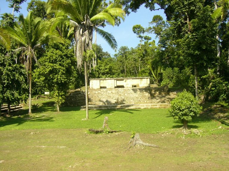
Structure 5, or Palace 5, is the highest palace at Tamarindito and may be the oldest building in Group A. Its interior measured 20 by 2 m and held one, or possibly two, simple rooms without benches beneath a vaulted roof. The north-facing building had one uncovered doorway, and may have had a second, on that side. It faced away from Group A’s Main Plaza. A broad staircase rose from the plaza, but reaching the entrance required going around the building. The palace fronted Structure 7 immediately to its north. Excavation exposed an earlier substructure 2 m below a second stucco floor.
Structure 7
Structure 7, or Palace 7, is a Late Classic building immediately north of Structure 5, facing south toward it. Its single room measured 8 by 2 m and originally had a vaulted roof. The main entrance was centered in the south wall; a smaller doorway in the east wall had been blocked in antiquity. Two stone benches stood inside, one against the north wall opposite the entrance and the other at the west end. Red and orange stucco covered the exterior, with red stucco on the interior. Two looters’ trenches cut into its summit in the 1980s damaged part of the west side; the remains were stabilized in the 1990s.
Structure 13
Structure 13 in northern Group A preserves three construction phases. Its earliest Early Classic form was a 1 m-high wall with a stucco floor at its base; later building work destroyed the west side. In the Late Classic, builders created a 1.5 m-high platform facing east onto a small plaza, reached by a low staircase. A final phase replaced an earlier three-step staircase with one of six steps. A bench with a niche stood opposite the stairs, and the plaza had a stucco surface.
Burials
Burial 2 in Group A contained the remains of a woman and dates to the Late Classic. Burial 3, from the beginning of the Late Classic, held part of an adult’s remains and two ceramic objects as an offering.
Group B and its monuments
Group B combines ritual, administrative, and residential buildings around its principal plaza. Structures 32 and 33 served administrative functions in the North Plaza. Structures 31, 32, and 33 also form a small plaza beside it. The group contains all three of Tamarindito’s hieroglyphic stairways, whose inscriptions preserve accounts of the city’s dynastic history.
Structure 44 and Hieroglyphic Stairway 2
Structure 44 is a 10 m-high pyramid on the west side of Group B’s Central Plaza and is among Tamarindito’s tallest buildings. Its summit has been heavily damaged by looting. Hieroglyphic Stairway 2, also known as the Prisoner Staircase, forms its first five steps. The remaining, narrower steps carry no sculpted text. The stairway climbs 8 m up the pyramid’s east side to a summit shrine. Three east-facing doorways, each just under 2 m wide, open into a single room measuring 10 by 3 m. Its thick walls are made of finely worked stone. The stairway’s text recounts the capture of Dos Pilas’s last king and Tamarindito and Arroyo de Piedra’s victory in 761.
The royal tomb
A royal tomb lies 10 m beneath the temple of Structure 44 and is attributed to Chanal Balam. Its vaulted ceiling collapsed, damaging poorly preserved bones laid on their backs with the head toward the north. The body rested on a fine layer of obsidian, a volcanic glass used for sharp-edged tools. More than 460 kg each of flint and obsidian chips were found in layers around the tomb after the burial rites; flint was more abundant.
Beside the skull, in the part of the tomb where the ceiling remained intact, lay nine ceramic vessels: four painted in several colors, three earthenware bowls, and a tripod plate. The plate’s rim and supports bear the emblem glyph of the Motul de San José polity. One painted vessel depicts courtly life, including a king of that polity. These objects are thought to have been gifts from Motul de San José and do not name Tamarindito’s ruler. Other offerings included a stingray spine by the pelvis, an obsidian knife at the waist, and a 50 cm flint knife on the chest. A spondylus, a marine shell used in ornament and ritual objects, jade earspools, and jade necklace beads were placed by the head. As of 1995, this was the richest offering found with an elite burial in Petexbatún. Stela 5 depicts an Early Classic ruler holding a stone knife similar to the obsidian knife from the tomb. Inscriptions on the funerary temple celebrate Chanal Balam’s victory over Dos Pilas.
Structure 61
Structure 61 has a chultun, an underground chamber cut into limestone or bedrock, beneath the central line of its staircase. The chamber was carefully sealed while empty before Tamarindito was abandoned. It is thought to have been intended as a burial place but was never used.
Hieroglyphic Stairway 3
Hieroglyphic Stairway 3 was discovered in 1984 and later removed by Guatemala’s Institute of Anthropology and History. Its surviving text includes Tamarindito’s emblem glyph and the title ahau, used for a ruling lord.
Residential compounds
Twelve residential complexes have been mapped on the hillsides east of the core. They contain 56 structures across about 1,450 m². A common plan placed four buildings around a central courtyard. Group Q4-1 lies low on a hillside near agricultural terraces and a water source; its ceramic remains date to the Terminal Classic.
Groups Q5-1 and Q6-1
Group Q5-1 consists of four buildings around a courtyard, with its tallest structure, a pyramid, on the west side. The group dates to the Late Classic, although Early Classic ceramics were mixed with later ceramics in building fill. Seven high-status Late Classic burials were distributed among three structures. Group Q6-1 has a similar courtyard plan and a western pyramid. Early Classic ceramics from a looters’ trench in its western building appear to come from an earlier substructure beneath the Late Classic pyramid. Occupation at Q6-1 continued into the Terminal Classic.
Group Q5-2
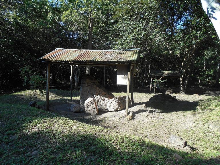
Group Q5-2, which dates to the Late Classic, contains a large cut-limestone block that may have served as a stela base. Beneath its principal building is a small cave. Near the cave entrance, excavators found a shell cut lengthwise to make an inkwell, an object depicted in Maya art. This discovery led to the interpretation of the compound as a scribe’s residence.
Group Q6-2 and the stone workshop
Group Q6-2 lies fairly close to Group A. Its buildings occupy three sides of a courtyard, leaving the fourth open. The Late Classic complex was high-status, with well-cut stone buildings, rooms with benches, and stucco floors. It appears to have housed artisans who made luxury and ritual stone objects for the elite. Stone-working waste and flint hammers from Structure Q6-9, a low southern platform, support its identification as a workshop. Burial 4 in Structure Q6-8, on the group’s west side, contained abundant stone chips. Depositing stone over a burial was an elite practice in the region, and this is the only known Petexbatún example of the rite in a non-elite setting. A complete eccentric flint, a deliberately shaped flint object, came from rubbish north of Structure Q6-8.
Groups R6-1 and R6-2
Group R6-1 resembles Q5-1 and Q6-1, but its taller pyramid stands on the south side of the courtyard. Blocks of dolomitic limestone form its basal platform. A circular altar stands at the pyramid’s base, and a small building occupies the courtyard center, an uncommon arrangement in the Maya lowlands, with other examples at Tikal and Uaxactun. The group dates to the Late Classic. Group R6-2 has buildings around three sides of a courtyard, leaving the fourth side open.
Agricultural landscape
Fertile land between Tamarindito and Aguateca was cultivated intensively during the Late and Terminal Classic. The agricultural system included low boundary walls, sunken gardens, box terraces, and dams. Many terraces are now covered by secondary scrub. Some follow hillside contours for as much as 210 m and are marked by rows of stones; others occupy a hollow between two hilltops and consist of small dykes made from lines of large stones. Tamarindito was the Petexbatún region’s most productive agricultural center.