Hattusa: Capital of the Hittite Empire in Anatolia
Site at a Glance
- Popularity
- Very High
- Country
- Turkey
- Primary era
- Bronze Age
- Eras represented
- Bronze Age, Iron Age, Classical, Medieval
- Civilizations
- Byzantine, Celtic, Hittite, Phrygian, Roman
- Site type
- City
On this page30 sections
History
Hattusa is an ancient city near Boğazkale in Türkiye that became the capital of the Hittite kingdom around the middle of the seventeenth century BC. Before the Hittites established their capital there, it was an important center of Hatti, an earlier people and cultural tradition of central Anatolia distinct from the Hittites.
Early settlement and trading colony
People occupied the site from the sixth millennium BC, at first concentrating on Büyükkaya. Settlement remained sparse for a long period, then grew more urban in the late third millennium BC, when multi-room buildings, metalworking, and pottery production appeared.
In the early second millennium BC, the city was known as Hattuš. Assyrian merchants maintained a trading station in the Lower City during the nineteenth and early eighteenth centuries BC. They exchanged Anatolian metals, including copper, silver, and gold, for tin and textiles brought from Assyria. Their clay-tablet records used cuneiform, a writing system made of wedge-shaped signs, and introduced writing to the region. One record concerns the merchant Daya, who sold textiles sent by his wife from Assyria.
Around 1700 BC, fire destroyed Hattuš. Anitta, a king associated with Kuššara, claimed to have captured and burned the city and cursed anyone who resettled it. The evidence of fire supports the destruction, but later finds indicate that at least some people may have remained.
Hittite imperial capital
Around the middle of the seventeenth century BC, a ruler known as Labarna established his capital at Hattusa and adopted the royal name Ḫattušili I, meaning “man of Hattusa.” Later tradition placed this refoundation in defiance of Anitta’s curse. Hattusa became the capital of the Hittite Empire and remained so until the kingdom’s end, except for a few decades when Muwatalli II moved the capital to Tarhuntassa in southern Anatolia.
Ḫantili I claimed to have been the first ruler to wall the city, probably in the late seventeenth or early sixteenth century BC, although earlier defenses may have existed. The fortifications helped guard against the Kaška peoples, who lived north of the Hittite heartland and repeatedly threatened its territory. Hattusa burned again around 1400 BC, probably during a Kaška attack.
From the sixteenth century BC, the city expanded and its districts were reorganized. The Lower City grew around the Great Temple, while planned construction in the Upper City included residences, temples, and water-storage facilities. Hattusa also stood on overland routes linking central Cappadocia with the Black Sea region and connecting routes to the east and west. Its population is uncertain: estimates range from about 10,000–12,000 to 20,000–40,000 at the city’s greatest prosperity.
Agriculture and livestock supplied much of the city’s food. Residents grew grains, pulses, vegetables, herbs, and fruit; grain was made into bread, bulgur, and beer, as well as fed to animals. Cattle, sheep, and goats were the main livestock, with smaller numbers of pigs. Animals also provided milk, wool, and labor. Horses, donkeys, and mules carried people and goods, and texts mention beekeeping for honey. Hunting appears to have been mainly a royal pastime. Hattusa’s dry climate and limited irrigation made stored water and grain important to its survival.
Late Hittite rule and abandonment
In the early thirteenth century BC, Muwatalli II transferred the capital to Tarhuntassa. The reason is unknown; religious and strategic explanations have been proposed. The move also involved the gods of Hatti and the spirits of the ancestors. His successor, Muršili III, returned the capital to Hattusa after a few decades, but was deposed by his uncle Ḫattušili III.
Under Ḫattušili III and his son Tudḫaliya IV, Hattusa entered a final phase of major building activity. The palace complex and Great Temple were enlarged or restored, and the Upper City developed as a major religious district. During and after the transfer of the capital, some temples there were abandoned and their locations reused for pottery and other craft production.
Tudḫaliya IV’s son Šuppiluliuma II left inscriptions at Hattusa and established a cult complex near the eastern reservoirs. In the early twelfth century BC, the Hittite Empire collapsed and the city was abandoned. The causes remain uncertain; proposed factors include political conflict, famine, environmental or resource pressures, and disruption of long-distance trade. Fires affected buildings, but their date is unclear and does not prove that the city was captured. Some temples had been emptied beforehand, consistent with the possibility of an organized departure by the court and population. A further capital transfer has been proposed, though its destination is unknown.
Later settlements and rediscovery
A smaller settlement continued or developed on Büyükkaya after the Hittite capital’s abandonment. Its residents may have included Hittite survivors or newcomers from northern Anatolia. Later communities occupied parts of the site as well. Büyükkale was fortified again in the eighth century BC and associated with Phrygian culture, an Iron Age tradition of Anatolia. A separate fortified settlement, the South Castle, arose in the seventh or sixth century BC. Persian rule brought no clear material change, and Hattusa had lost importance by the fifth century BC, although the extent of later abandonment is uncertain.
From the third century BC, Galatian groups, including the Trokmi, occupied parts of the site. Rome took control of the region around 25 BC. In the first century AD, a Roman military camp at Hattusa was later covered by a villa, and ancient stonework was quarried for reuse. A Byzantine settlement flourished mainly in the Upper City during the tenth and eleventh centuries AD, with a monastery and churches. Coins suggest that occupation ended later in the eleventh century, probably amid the arrival of Turkish groups in the region.
In the seventeenth century, a branch of the Dulkadir family founded Boğazköy, now Boğazkale, about three kilometres south of the ancient city. The community had first settled at Yekbas, then moved from the Budaközü plain to a more sheltered location, probably because of unrest associated with the Celali revolts in Ottoman Anatolia.
Charles Texier brought the site to wider scholarly attention in 1834, though he identified it as Tavium; Georges Perrot later proposed Pteria. Ernest Chantre’s trial excavations in 1893–94 uncovered cuneiform tablets. Systematic work began in 1906 under Hugo Winckler and Theodor Makridi, with support from the German Oriental Society and the Ottoman Museum. The tablets identified the ruins as Hattusa, the Hittite capital, and later enabled the Czech scholar Bedřich Hrozný to decipher Hittite.
Excavations paused during the First World War, resumed in 1931, and stopped again in 1939 because of the Second World War. Work restarted in 1952 under the German Archaeological Institute and continued alongside conservation. Research in 2022 identified 249 red-brown painted hieroglyphic signs in the tunnel beneath Yerkapı; they are separate graffiti rather than one continuous text. In 2023, excavators found a cuneiform text in the previously unidentified language of Kalašma, recognized through its Hittite introduction.
Hattusa and the nearby sanctuary of Yazılıkaya were inscribed together on the UNESCO World Heritage List in 1986. The city’s cuneiform tablet archives were added to UNESCO’s Memory of the World Register in 2001, which recognizes documentary heritage.
Remains
The archaeological site covers a rocky landscape where the Budaközü plain meets steep country to the south. The ground rises about 280 metres over roughly 2.1 kilometres from north to south. The Lower City lies mainly north of the Upper City, which climbs southward; Büyükkale stands between them, and Büyükkaya is about 500 metres farther north. The ancient city covered roughly 160–180 hectares, although its full extent has not been excavated. Streams cut ravines through the area and join near modern Boğazkale; springs, cisterns, and reservoirs supplied water.
Defenses, gates, and streets
City walls
The outer Hittite walls had a perimeter of about 6.6 kilometres, while the walls, including internal divisions, extended for more than nine kilometres. Builders incorporated ridges and ravines into the defenses. The oldest known Hittite fortification, the Postern Wall, enclosed the Lower City, running from Kesikkaya past Büyükkale and around Büyükkaya. Its northern course crossed the Budaközü ravine and may have been closed by a barrier across the stream. Some sections now lie beneath the modern settlement or fields; restored foundations and tunnels can be seen east of Kesikkaya.
Eight small tunnels are known along the Postern Wall between Kesikkaya and Büyükkale. Built with corbelled masonry, in which successive courses project inward until they meet, they are concealed beneath the wall. Their purpose is uncertain, though they may have provided passages for sudden sorties. A further gate in the wall west of Kesikkaya was excavated in 2009. The Upper City wall joined the Postern Wall west of Kesikkaya and met the earlier defenses again near Büyükkale. Its construction date is uncertain, but it probably existed by the time the Upper City was intensively occupied. An internal wall passed west of the Great Temple, and a later wall protected grain stores on Büyükkaya. A second wall was added in front of the southern rampart in the late thirteenth century BC.
Hittite walls commonly used two parallel walls joined by crosswalls, forming compartments filled with earth, stones, and broken mudbrick. Rubble foundations rested on earthen ramparts; the upper sections used sun-dried mudbrick reinforced with timber and plastered over. More than a hundred projecting towers are known or inferred. Their height is uncertain, but estimates suggest stone bases perhaps three to four metres high, with upper sections of similar height and a walkway protected by battlements.
Monumental gates
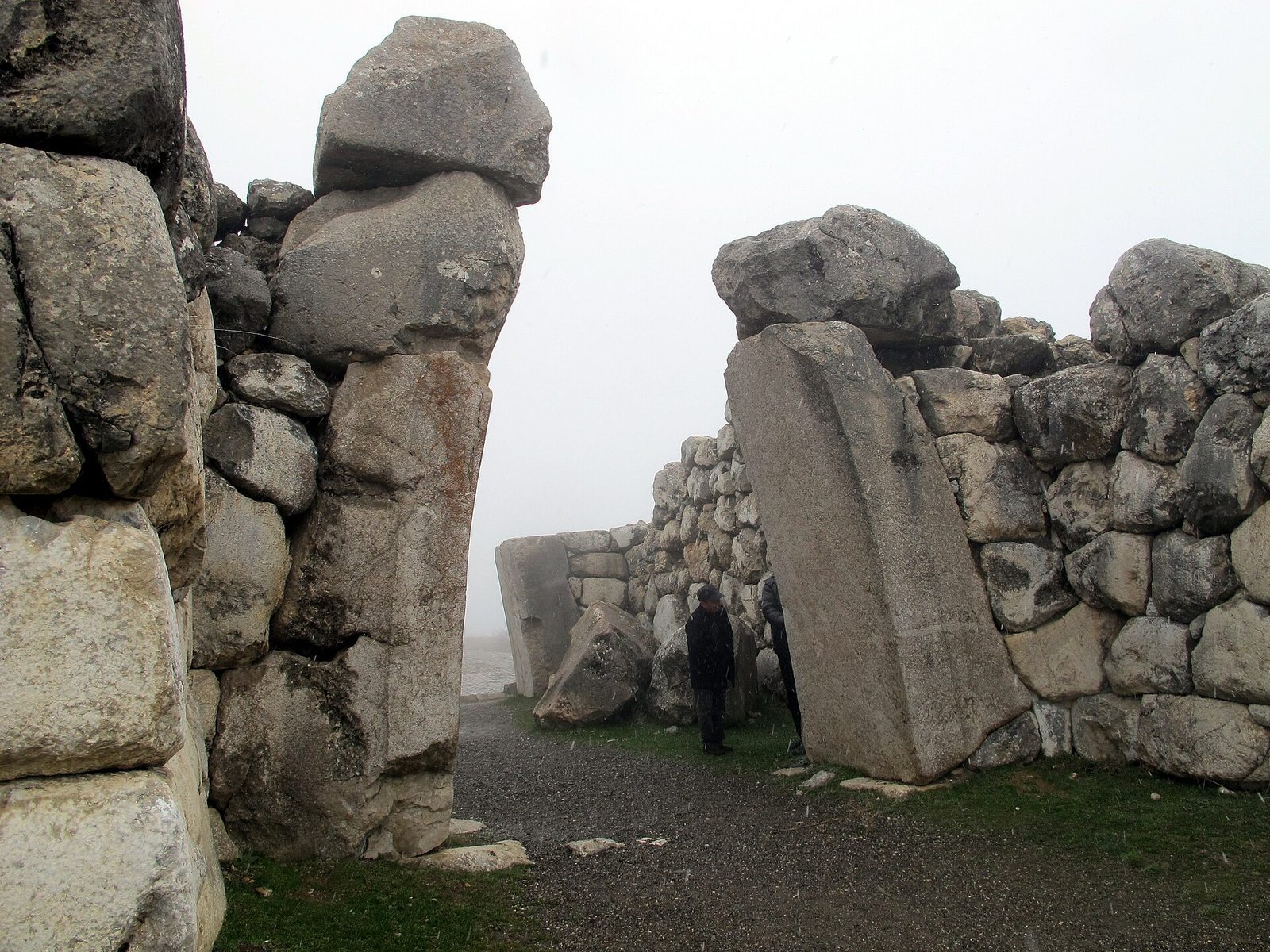
Five monumental gates pierced the Upper City’s outer wall: the Lower West Gate, Upper West Gate, Lion Gate, Sphinx Gate, and King’s Gate. At least two more stood in the wall between the Upper and Lower cities. The southern gates apart from the Sphinx Gate had curved passages, wooden doors, and flanking towers. At the King’s Gate, the recesses for locking bars and marks left by the doors remain visible.
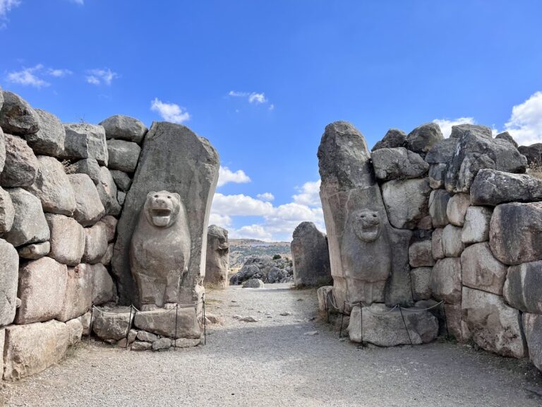
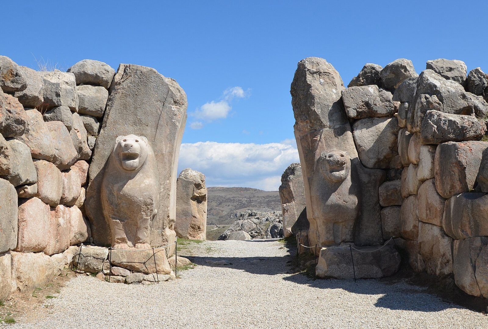
The Lion Gate’s passage ran between rectangular towers measuring about 10 by 15 metres. Polygonal masonry survives on the western tower, whose outer face stands to 4.6 metres. An approach ramp came from the east, protected by another wall and tower. Two carved lions gave the gate its modern name; their heads, paws, manes, and open mouths were carefully shaped. Faint hieroglyphs beside the western lion include a sign for “gate.” The left lion’s head, lost in antiquity, was reconstructed during modern restoration.
The Sphinx Gate passes through a tower rather than between flanking towers. Its rectangular opening has a lintel, with closable wooden doors on the outer side and an open inner side. Stairs on either side of the Yerkapı rampart provided access on foot. Four sphinxes once guarded the entrance. Fragments of the outer western figure remain in place, while the inner sphinxes, excavated in 1907, are displayed as restored originals in the Boğazkale Museum; replicas stand at the gate.
The King’s Gate has two towers and an approach ramp from the west, protected by another wall and a projecting defensive platform. Its relief, on the side facing the city, depicts a helmeted, armed figure in a patterned short skirt. The horns on the helmet indicate that the figure is a deity, not a king. It may represent Šarrumma, protector of Tudḫaliya IV, though the identification is uncertain. The original relief, found in 1907, is in the Museum of Anatolian Civilizations in Ankara; a copy stands at the gate.
Yerkapı rampart
At the southern edge of the city, Yerkapı is an artificial rampart about 250 metres long and 64–80 metres wide at its base. Its outer face rises about 30 metres beneath the Sphinx Gate. Stone paving covered much of the slope, with stairs at the eastern and western ends and rainwater channels cut into the paving at intervals of about 21 metres. A 71-metre tunnel passes beneath the rampart. Its corbelled ceiling, white-plastered floor, and double doors at both ends survive. Its purpose is uncertain; it is unlikely to have served as a military sortie passage and may have been used for ceremonies or cult performances.
Roads and drainage
Roads followed the terrain, connecting gates, temple areas, and the citadel. Some routes survive as cart tracks, while excavated paved roads and drains are particularly evident around the Great Temple. Two roads from gates west of the temple met south of it; other routes crossed the Upper City and followed the outer walls. Channels beneath streets carried rainwater and household wastewater. Hittite texts assigned their upkeep to the hazannu, a city official with duties that included supervising gates and drainage.
Temples, workshops, and water storage
Great Temple
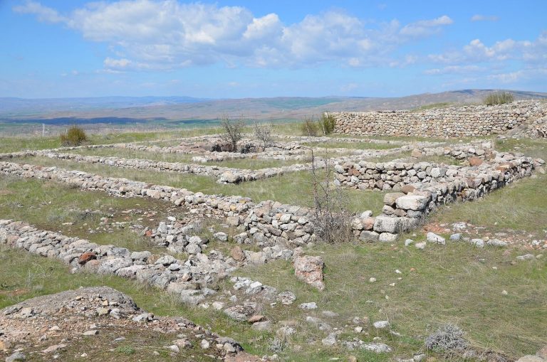
The Great Temple, also called Temple 1, stood on a raised terrace in the Lower City. The building measured about 64 by 42 metres and was oriented southwest to northeast; its stone terrace measured about 160 by 135 metres. A four-step entrance led to a paved route around the temple. Visitors entered from the southwest into an open court surrounded by rooms. A portico led to two inner sanctuaries, and a statue base stood against the northeast wall of the right-hand sanctuary. A small separate structure in a rear corner may have served as an altar. The temple is commonly associated with the Storm God of Hatti and the Sun Goddess of Arinna, although the identity of the deity in each sanctuary is uncertain.
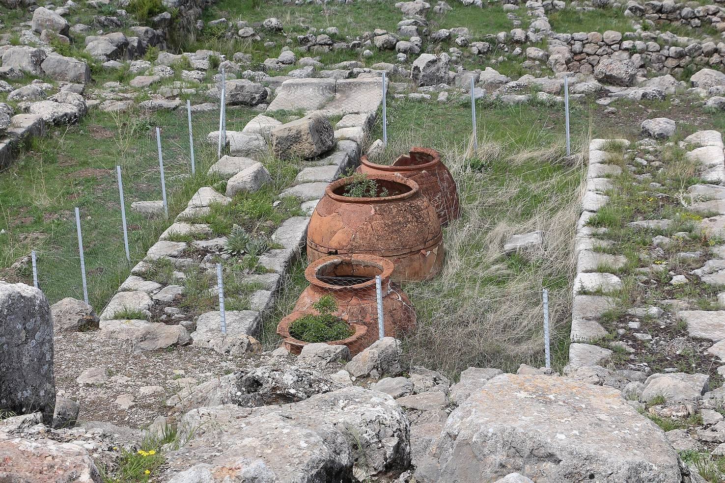
Eighty-two long storerooms surrounded the main building. Many held large storage jars set into the floor, some with capacities of up to 2,000 litres, for grain, pulses, oil, and wine. Rooms southeast of the temple held the archive, where thousands of cuneiform fragments were found. A green stone resembling nephrite stands in one storeroom, away from its original position; its purpose and origin are unknown.
Other Lower City buildings
Southwest of the temple, a paved road with drains led to a gate in the internal wall. Across the road stood a complex of about 5,300 square metres, with storage and cult rooms and probably workshops. Also called the House of Labor, it is associated by a tablet fragment with work by priests, craftspeople, musicians, and scribes. A small spring grotto lined with masonry lies south of it. An engraved figure and a hieroglyphic-inscribed stone point to a cultic function.
Residential buildings stood irregularly around the Great Temple. On the Northwest Slope, the House on the Slope measured 32 by 36 metres and had two storeys. Its upper level included a hall about 13 by 17 metres; the lower level appears to have contained work and storage rooms, where many tablets were found. A fire in the late thirteenth century BC destroyed the building, which was not rebuilt. Burnt mudbrick survives in parts of its upper walls and is protected by a later enclosure.
Upper City temples
The Upper City contained at least 27 temples built between the sixteenth and fourteenth centuries BC, and more than 30 temple remains have been identified across Hattusa. Their plans commonly included an entrance, an open court, a portico, and an inner sanctuary; some stood within walled sacred precincts. Temple 5, near the King’s Gate, was the largest Upper City sanctuary. Like the Great Temple, it had two inner sanctuaries and a small altar-like structure in its court. A relief of a ruler named Tudḫaliya in warrior dress came from an associated building, but which king it represents is unknown. Temple 30, between the Lion Gate and Yenicekale, has restored foundations; pottery workshops were later built over it.
South and East Ponds
The South Ponds began in the sixteenth century BC as a large underground grain store and were later converted into five reservoirs, each up to eight metres deep. Their stone-lined edges remain visible. The basins were kept narrow to limit evaporation and divided to reduce the danger of dam failure or contamination. Groundwater seepage probably filled them. East of the King’s Gate, two further reservoirs each measured about 60 by 90 metres. Their floors were sealed with impermeable clay and their sloping sides paved. Clay pipes ran beneath the gate, although the ponds’ role in water supply is uncertain and they may also have served a cult purpose.
Two vaulted stone chambers were built into the northwestern end of the western East Pond’s embankment. The second chamber contains a relief of the Sun God, another of Šuppiluliuma, and a Luwian hieroglyphic inscription by Šuppiluliuma II. The inscription describes campaigns and building foundations and refers to a sacred “earth road,” a phrase comparable to the Hittite term for a passage to the underworld.
Palace and administrative areas
Büyükkale palace
Büyükkale is a rocky plateau about 260 by 150 metres, occupied from at least the late Early Bronze Age and fortified by about 1900 BC. The Hittite palace complex was rebuilt on a monumental scale under Ḫattušili III and Tudḫaliya IV. A raised route accessible to wheeled traffic approached from the southwest. Inside its defenses, three successive courts connected administrative buildings and service quarters with a reception hall and royal residence. Gates decorated with reliefs, including lions, separated the courts. Building M is associated with administration; Building H had four long, parallel storerooms; Building C may have served a cult purpose; and Buildings E and F may have contained royal apartments. Building D, a columned hall, is interpreted as a reception or audience space. Many royal tablets were found in Building A, with further tablets from Buildings K, D, and E.
Grain stores
Eleven grain-storage pits have been excavated on Büyükkaya. The largest, about 12 by 18 metres and more than two metres deep, could hold at least 260 tonnes of grain. The pits were sealed to limit air and pests. Another underground granary near the Postern Wall, between Büyükkale and Kesikkaya, had 32 rectangular compartments and was reburied after excavation to protect it. A separate Lower City storage complex measured about 60 metres long and 30–40 metres wide, with sixteen chambers arranged in two rows.
Nişantepe and nearby buildings
Nişantepe takes its name from a large inscription on its northeastern face. The text occupies a smoothed area of rock about nine metres long and 2.4 metres high. Its eleven lines alternate direction, and weathering has made them difficult to read. The opening names Šuppiluliuma II as the son of Tudḫaliya IV and grandson of Ḫattušili III. Possible building remains and a ramped entrance guarded by sphinxes survive on the summit. On flatter ground to the north, the West Building yielded thousands of clay sealings and some tablets, suggesting an administrative function; the purpose of nearby buildings is uncertain.
Rock outcrops and other remains
Büyükkaya and Ambarlıkaya
Büyükkaya is about 500 metres long, with a western cliff rising roughly 100 metres above a stream. It was occupied from at least the fifth millennium BC and later held Early Bronze Age houses, metalworking installations, and a Hittite monumental building, of which only foundations remain. Cuttings on the summit of Ambarlıkaya, between Büyükkale and Büyükkaya, indicate a monumental building, although no standing remains survive. The city wall descended along Ambarlıkaya’s slope and crossed a ravine, where it may have been secured at the stream.
Kesikkaya
Kesikkaya is a rocky outcrop divided by an artificially widened cleft with vertical sides. Excavations nearby have uncovered Hittite buildings, remains of an earlier trading-period settlement, and a possible monumental structure of the early sixteenth century BC. In that structure, a triangular room points toward a shaft cut into the cleft. A cultic purpose, possibly involving access to the underworld, has been suggested but remains uncertain. A small Galatian-period fortress and an Iron Age monumental building were also found nearby. Quarry cuts show that the rock was reused in Roman times and possibly under the Byzantines.
Kızlarkayası
Kızlarkayası measures about 29 metres from east to west and 32 metres from north to south. Its sides and upper surface bear extensive Hittite working, including smoothed areas, recesses, and possible statue bases. Its religious purpose is uncertain; it may have been a cult installation associated with the Sun Goddess of Arinna and Mezulla. A regulated streambed to the north may be relevant to that interpretation.
Sarıkale and Yenicekale
Sarıkale rises about 60 metres above the valley. Its summit retains remains of a Hittite building with a fortification and cistern, interpreted as a possible public or religious structure. The building was later adapted into a Byzantine fortified complex. Yenicekale has a levelled rock platform about 25 by 28 metres, enlarged at the edges with large limestone blocks. Little of the building that once stood on it survives; it may have been another structure of the kind found on rocky summits.
Mihraplıkaya
A semicircular niche is cut into the north face of Mihraplıkaya. It was once interpreted as the apse of a Byzantine church, but that explanation is now considered less likely. Excavations to the west uncovered a Roman imperial-period monumental building over an earlier Roman fortification, a pool about 45 by 20 metres, and a painted reception building aligned toward the niche.
Later occupation and archaeological finds
Iron Age, Roman, and Byzantine remains
The Iron Age South Castle developed on a plateau north of the chambers beside the East Ponds, over the location of Hittite Temple 31. Probably built in the seventh century BC, it was a fortified settlement with substantial walls, a western entrance flanked by two towers, and houses, workshops, and storage buildings.
Roman remains include the military camp later covered by a villa, cemeteries around the Great Temple and in the Lower City, and a small possible late-imperial fort on Büyükkale. Quarrying marks appear on rock faces and on blocks from the Great Temple, especially at Kesikkaya. The Byzantine settlement included a monastery and churches of the tenth and eleventh centuries. Parts of these buildings have been excavated and restored, with architectural pieces from earlier buildings reused in their construction. A church remains in the northern part of the Upper City temple district, and other Byzantine remains occur on Sarıkale and Yenicekale.
Tablets and other finds
More than 30,000 cuneiform tablet fragments have been recovered at Hattusa. Written in Hittite, Old Assyrian, and other languages, they preserve political, administrative, legal, religious, and literary material. Among the texts are the Hittite version of the peace treaty concluded in 1259 BC between Ḫattušili III and Ramesses II, an agreement between Tudḫaliya IV and Kurunta concerning Kurunta’s position and Tarhuntassa, and palace service regulations known as the Mešedi text.
A complete bronze tablet found in 1986 beneath paving near the Sphinx Gate carries about 350 lines of a treaty between Tudḫaliya IV and his cousin Kurunta, ruler of the Hittite vassal kingdom of Tarhuntassa. It was the first Hittite bronze tablet to be found and is now in the Museum of Anatolian Civilizations in Ankara. A 79-centimetre sword of Mycenaean style, discovered in 1991 southwest of the Lion Gate, bears an Akkadian inscription saying that a king Tudḫaliya dedicated swords to the Storm God after defeating Assuwa. The royal name identifies him as Tudḫaliya I/II. The sword supports the account of the campaign but does not establish a battle between the Hittites and Mycenaeans. A fragment of a pale red terracotta bathtub found in a Lower City dwelling in 2003 has an internal seat, suggesting an ordinary bathing tub rather than a ritual basin.
Yazılıkaya sanctuary
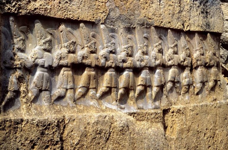
The rock sanctuary of Yazılıkaya lies about 1.5–2 kilometres east of Hattusa and was inscribed on the World Heritage List with the city. Its two chambers contain more than 80 carved reliefs, including processions of Hittite deities and several images of Tudḫaliya IV. Chamber B may have served a funerary cult. Foundations of a building excavated before the chambers enclosed the sanctuary. The place may have served as a cult site, or possibly as a burial place, before its reliefs were carved in the thirteenth century BC.