Yarkhoto: An Ancient Silk Road City in Xinjiang
Site at a Glance
- Rating
- 4.5
- Popularity
- Low
- Country
- China
- Primary era
- Medieval
- Eras represented
- Iron Age, Classical, Medieval
- Civilizations
- Unclassified
- Site type
- City
On this page22 sections
History
Yarkhoto, also known as Jiaohe, is an ancient city in the Yarnaz Valley west of Turpan in Xinjiang, China. Established around the 2nd century BC by a community associated with the Jushi people, it occupied a strategic position on the route linking eastern and western regions of the Silk Road. Its location on a naturally defended plateau helped it become a political, economic, cultural, and military center.
Jushi and Han rule
Human activity in the surrounding plateau reaches back more than 20,000 years, and Paleolithic stone tools have been found west of the city. The Jushi people combined farming with pastoralism and established a settlement that later became the capital of the Anterior Cheshi Kingdom. The Anterior Cheshi was an ancient state centered in the Turpan region, and its name reflects the term used for the polity and its people in Han-period records.
Yarkhoto enters historical records clearly in 108 BC, when Han commanders led by Zhao Ponu defeated the Gushi polity and reorganized the region into eight Cheshi states. Yarkhoto became the capital of the Anterior Cheshi Kingdom and continued as its political, economic, and cultural center. During the Han period, it was also associated with a defensive settlement and granary. The Protector of the Western Regions was first established there to supervise military colonization and administration, giving the city an important role in the Han presence in the region.
From royal capital to regional center
In 450, Juqu Anzhou captured Yarkhoto and ended the Anterior Cheshi Kingdom. Under Northern Liang rule, the city became the seat of Jiaohe Commandery and Jiaohe County, changing from a royal capital into a regional administrative center. In 460, the Rouran defeated Gaochang Northern Liang and installed Kan Bozhou as ruler of Gaochang. Yarkhoto then remained under the Gaochang kingdoms. During the Kan, Zhang, Ma, and Qu dynasties, it was one of Gaochang’s forty-six military settlements and the second-largest town after Gaochang City.
The Tang dynasty conquered Qu Gaochang in 640 and established Xi Prefecture, which included Jiaohe County. Soon afterward, the Anxi Protectorate was established at Yarkhoto. This was the Tang administration’s senior military and political institution in the Western Regions, combining government, military command, and agricultural settlement. From 640 to 658, Yarkhoto served as the seat of the Protector General of the Western Regions and again became a major political, military, and agricultural center on the Silk Road.
Tibetan and Gaochang Uyghur periods
Yarkhoto later came under the Tibetan Empire. From the early ninth century, it functioned as a prefecture and military stronghold of the Gaochang Uyghur kingdom, a medieval Uyghur state based in the Turpan region. Buddhist religious and artistic remains from this period are especially prominent at the site. The city’s development became increasingly restricted as it declined, although it remained part of the regional political and military system. In the early thirteenth century, the Gaochang Uyghur kingdom became subordinate to the Yuan dynasty.
Warfare involving Duwa, ruler of the Chagatai Khanate, Haidu of the House of Oegedei, and Yuan forces brought repeated attacks against the Gaochang Uyghur kingdom. By the late thirteenth century, when the Uyghur royal house moved east to Yongchang in Gansu, Yarkhoto had suffered extensive war damage and largely disappeared from historical records. In the fourteenth century, further warfare and Islamization under Khizr Khoja contributed to the destruction and abandonment of the city, which had been an important Buddhist center in the Gaochang region. Declining overland Silk Road traffic, social and economic change, new military technologies, reduced rainfall, desertification, and the depletion of land resources added to the decline.
Abandonment and archaeological investigation
During the Ming period, the official Chen Cheng described Yarkhoto as being abandoned. He noted about one hundred households, former temples, and surviving stone inscriptions. Muslim graves dating from around the late fourteenth century occur in the administrative district, while the scarcity of Yuan-period and later objects indicates that the city was not substantially reused after its abandonment.
European exploration began in the late nineteenth century. Dmitri Klementz examined Yarkhoto, the Yarghul caves, and nearby cemeteries in 1898, followed by expeditions from Russia, Britain, Germany, Sweden, France, Japan, and the United States. Aurel Stein produced a site plan, excavated residential compounds and temples, and investigated the area near the Great Buddhist Temple. German expeditions between 1902 and 1914 removed more than 900 cases of antiquities from the Turpan region, including objects from Yarkhoto. Paul Pelliot excavated documents, textiles, and coins between 1906 and 1909. Objects from these and other expeditions entered collections in Berlin and at the Musée Guimet, as well as other foreign museums.
Chinese archaeological work expanded with Huang Wenbi’s investigation in 1930. He prepared plans of Yarkhoto and the Gouxi cemetery and distinguished Cheshi, Gaochang, and Tang cultural phases. Training excavations in 1956 cleared fifteen rooms and more than twenty graves, recovering over 700 objects, including epitaphs, pottery, and coins. Further surveys examined the Yarghul caves and nearby cemeteries. The Xinjiang Institute of Archaeology excavated and documented Yarkhoto and seven nearby cultural remains in 1993 and 1994, while work at the Gouxi cemetery continued through 1996 and during rescue excavations in 2004 and 2005.
Yarkhoto was designated a Major Nationally Protected Cultural Heritage Site in 1961. The nearby Gouxi and Goubei cemeteries and the Yarghul caves were added to the protected heritage unit in 2001. In 2014, Yarkhoto became part of the UNESCO World Heritage property Silk Roads: the Routes Network of Chang’an-Tianshan Corridor.
Conservation has addressed unstable cliffs, erosion, flooding, seismic activity, wind and sandstorms, and the fragility of earthen structures. A joint China, Japan, and UNESCO program operated from 1992 to 1996, followed by emergency stabilization in five phases between 2006 and 2022. Work included cliff stabilization, flood-control measures, repairs to temples, gates, roads, courtyard walls, and the administrative quarter, as well as monitoring and security systems. Earthen-brick infill, anchors, crack grouting, slope stabilization, and surface consolidation have been used to protect the surviving remains.
Remains
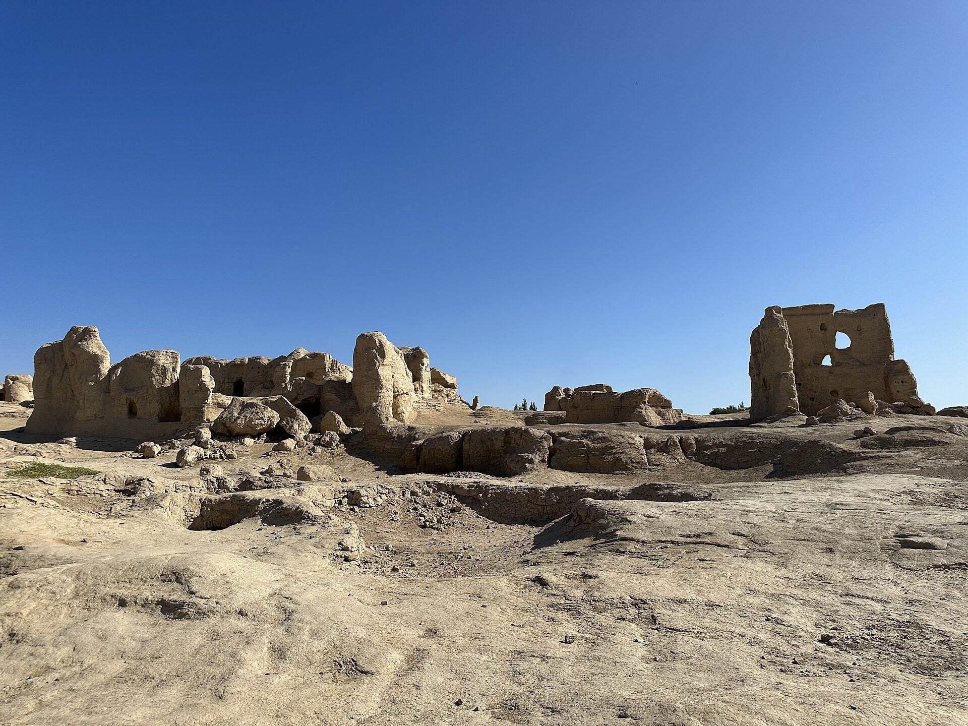
Yarkhoto occupies a willow-leaf-shaped plateau between two branches of the Yarnaz Valley. The plateau is about 1,650 to 1,750 metres long and approximately 300 metres wide at its broadest point. Ravines around it are roughly 20 to 30 metres deep, with steep cliffs that formed a natural defensive barrier. The two river channels flow around the plateau and meet south of the city, a configuration associated with the name Jiaohe, conventionally understood as “river junction.”
The plateau slopes downward from northwest to southeast. Its perimeter is about 4,100 metres, while estimates of the occupied area range from more than 375,000 square metres to about 470,000 square metres. The built archaeological remains cover approximately 380,000 square metres. The city had no continuous conventional city wall, although a protective wall followed parts of the cliff edge. Four beacon-tower remains outside the city served as warning installations.
Gates, roads, and urban layout
The principal urban areas include residential compounds, administrative buildings, storage areas, streets, Buddhist temples, and cemeteries. Walls, roads, and lanes separated and connected these zones. Two principal north-south roads formed the main circulation network. Residential compounds lay mainly near the southern and eastern entrances, storage facilities clustered near the East Gate, the administrative quarter occupied a central high area, and cemeteries lay in the north.
South Gate
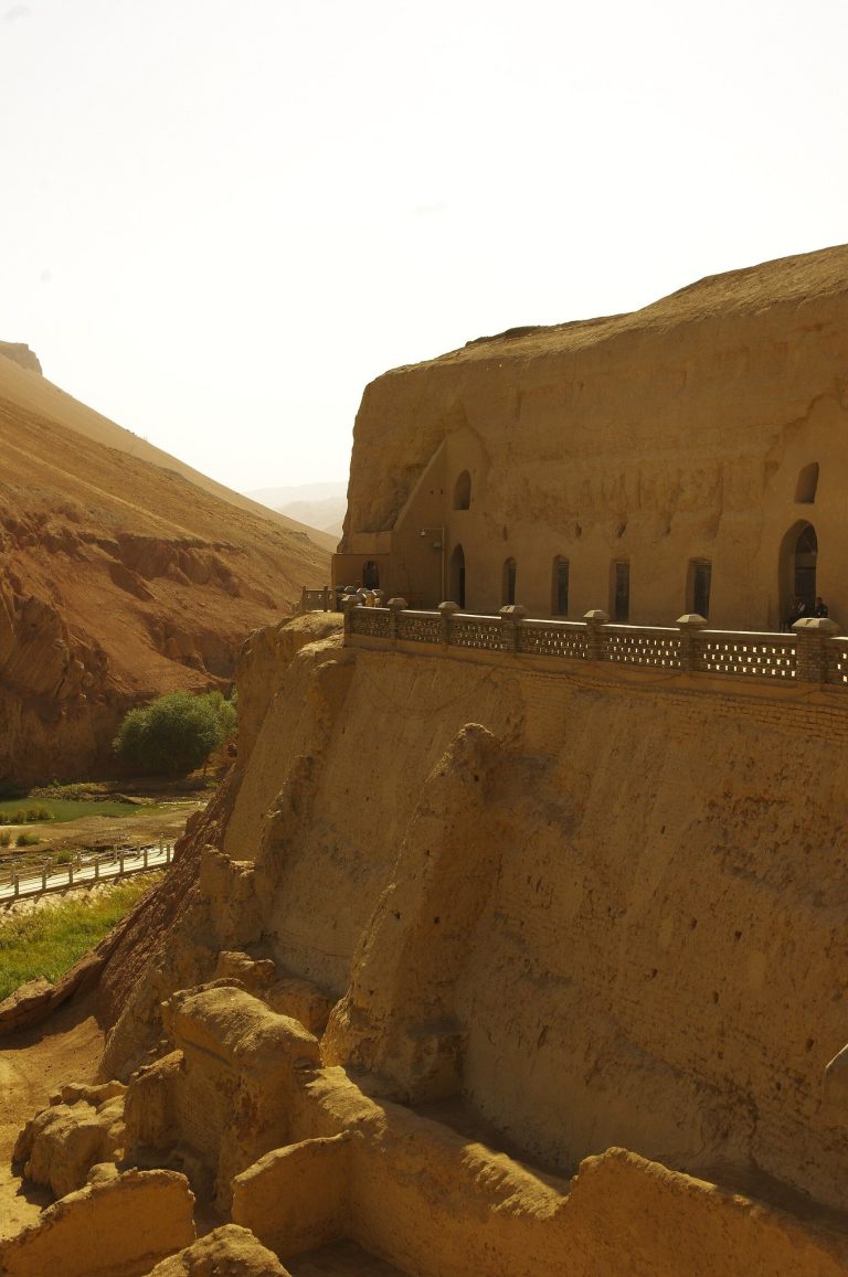
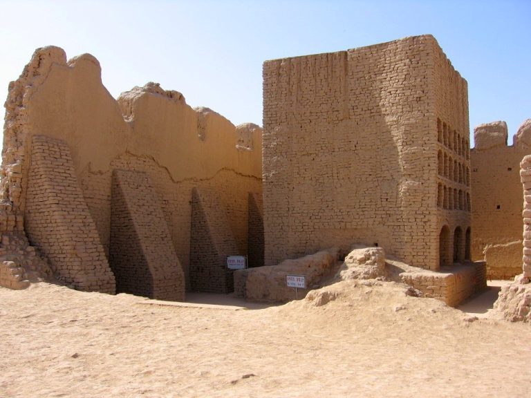
The present South Gate opens between two cliffs and begins the two principal roads. Its passage is nearly 7 metres wide and 11 metres long, runs approximately north-south, and rises from west to east at an incline of about 20 degrees. An older South Gate behind the site sign runs east-west. It is blocked by a brick wall and includes a northern gate wall about 14 metres high, two round-arched niches, earthen platforms, and a defensive blocking wall enclosing a courtyard connected to the Central Avenue.
East Gate
The East Gate is the largest and best-preserved gate. Its ascending approach leads to an outer gate, a semicircular barbican about 35 metres in diameter, and an inner gate. The cliff-cut approach is about 5 metres wide and 15 metres long and rises westward at roughly 15 degrees. Rammed-earth walls were strengthened with horizontal bundles of reeds and shrubs, while wooden wedges survive at the wall tops. The barbican connects with urban lanes through a large gate about 8 metres wide and 9 metres high, as well as a smaller passage. Pits, a well, and building foundations remain inside it.
Road network
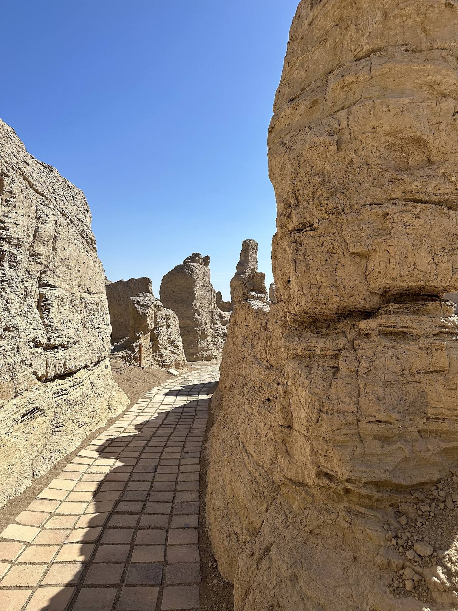
The Central Avenue follows a generally north-south course from the South Gate toward the Great Buddhist Temple. Its bow-shaped route has a paved surface of square bricks, and fourteen lanes branch from it. A second principal avenue crosses the administrative quarter, passes east of the storage area, and continues through the temple district to the Northeastern Buddhist Temple. Fifteen lanes branch from this road. An east-west avenue connects the two principal routes.
Temples and Buddhist monuments
Great Buddhist Temple
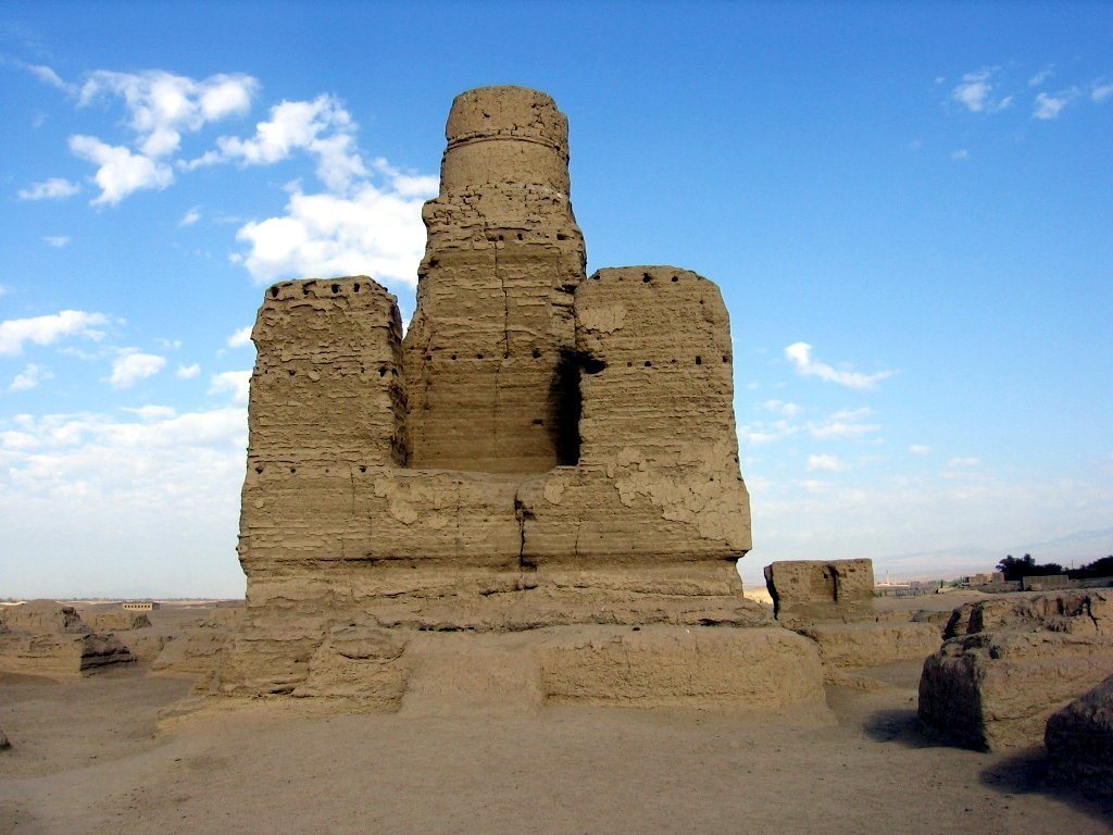
The Great Buddhist Temple is the largest temple at Yarkhoto. It stands at the northern end of the Central Avenue, slightly west and behind the Central Pagoda, and faces south. The complex measures approximately 90 metres from north to south and nearly 60 metres from east to west. Its buildings include a main hall, forecourt, pagoda, wells, platform, front hall, monks’ quarters, and other structures enclosed by temple walls.
The main hall stands on an earthen platform and has a rectangular plan. A square rammed-earth tower pillar rises from the center, with a Buddhist niche on each side and traces of molded Buddhist images. The temple was built during the Gaochang Uyghur period and remains relatively well preserved, with substantial wall height and clearly defined structures.
Other temples
At least nineteen other temple remains are known. The Southern Buddhist Temple is a Gaochang Uyghur-period cave-temple complex near the South Gate and may also have served as a lookout. Its associated square lookout structure measures about 5 metres per side and retains wall sections, an eastern exit, niches, a cave, and post holes.
The Northwestern Small Temple covers more than 466 square metres. Its entrance, courtyard, platform, main hall, side rooms, and corridor were built in different phases, with an earlier entrance facing south and a later entrance facing west. The Underground Temple occupies about 1,500 square metres in the northwestern cemetery area. Its subterranean rooms include a central Buddhist hall, monks’ rooms, niches, stairs, and part of a vaulted roof, together with fragments of towers, Buddhist figures, murals, wooden objects, and pottery.
Pagoda cemetery
The pagoda cemetery lies about 120 metres behind the Northeastern Buddhist Temple and covers approximately 2,500 square metres. It contains 101 monastic stupas arranged in four groups. Each group has a central vajra-seat-style stupa, a Buddhist monument based on the stepped square throne associated with the Buddha’s enlightenment at Bodh Gaya.
The principal stupa has a square raised base supporting five square towers, with the central tower largest. The cemetery faces south and is enclosed by walls around a court measuring about 84 metres east-west by 85 metres north-south. Most of the smaller stupas survive as foundations, while the main stupa is better preserved. The cemetery dates to the Gaochang Uyghur period.
Administrative and residential quarters
Administrative quarter
The administrative quarter covers about 5,000 square metres between the Central Avenue, the east-west avenue, and the eastern cliff. Its principal compound occupies a high platform. Rammed-earth walls, foundations, hitching pits, a large enclosure, and a subterranean structure survive. Steps lead down to an underground building containing cave rooms, wells, and tunnels. One tunnel reaches the surface through a cave and connects with an attached-building area.
The attached area includes a small pagoda and five courtyards arranged in a line. A temple complex beside the eastern cliff contains a Buddhist hall, underground structures, and wells and may have served as an official or state temple. Residences for officials occupied the southern part of the administrative temple area. The complex was used from the Han period through the Gaochang Uyghur period.
Residential compounds
Large residential compounds in the south represent the earliest developed part of the city. They combined roof-level sleeping areas, interior rooms, and underground cave rooms. Extensive cutting of the southern ground surface left some original earthen platforms visible, while many walls and rooms survive only as foundations less than 1 metre high.
The street-and-courtyard district contains thirteen compounds. The largest measures about 90 by 80 metres. Walls, gates, and lanes create enclosed spaces, with entrances generally opening onto side lanes. Most compounds contain a courtyard, a household Buddhist shrine or hall, and a well. Buddhist halls, altars, or pagodas often stand at the ends of lanes.
Cemeteries and caves
Northern cemetery
A boundary trench about 4 metres wide and 1 to 3 metres deep separates the northern cemetery from the rest of the city. Its burials include vertical-shaft graves, graves with side chambers, two-level graves, ear-chamber graves, and sloping-passage graves. Most date from the Cheshi period through Tang Xi Prefecture. Tang-period sloping-passage graves occur mainly north of the pagoda cemetery. Nearly 160 infant graves occupy about 400 square metres near the northwest of the administrative quarter, with dates extending from after the city’s abandonment into the Qing period.
Goubei and Gouxi cemeteries
The Goubei cemetery lies on a plateau north of Yarkhoto and contains about fifty-seven graves and fifty-five horse-sacrifice pits dating from the Eastern Zhou period to the Han period. Its finds include pottery vessels, bronze mirrors, gold ornaments, burial beds, and coffins. One large tomb was enclosed by an earthen-brick wall and accompanied by sixteen subsidiary graves and twenty-four horse-sacrifice pits.
Gouxi, west of Yarkhoto, dates from Qu Gaochang through the early Tang period. More than 2,000 graves extend across an area about 3 kilometres east-west and 1 kilometre north-south, with more than 300 excavated. Finds include household pottery, metal and wooden objects, Persian silver coins, Kaiyuan Tongbao coins, and numerous epitaphs. Documents and inscriptions use Chinese, Sanskrit, Tocharian, Brahmi, Turkic, and Uyghur scripts.
Yarghul caves
The Yarghul caves occupy loess cliffs on both sides of the Yarnaz Valley. Twenty-two caves survive, including square flat-roofed chambers, barrel-vaulted caves, worship caves, and meditation caves. The best-preserved western upper caves contain Chinese, Uyghur, and Turkic writings, including inscriptions with Manichaean content. Some show prolonged habitation, blackened walls, and hearths.
Cave 4 is the principal cave and the largest known rectangular longitudinally vaulted cave in Turpan. It contains Buddhist murals with evidence of repainting. Most caves were excavated during the Northern Liang period, while Cave 4 may date to the prosperous period of the Anterior Cheshi Kingdom and was repainted during the Gaochang Uyghur period. The caves remained in use until the decline of Gaochang Uyghur.
Water systems, construction, and finds
Wells are widespread, especially in built-up areas and residential compounds. Most have circular openings, although rectangular examples also occur. Their shafts are generally 1 to 2 metres in diameter, with many measuring 1 to 1.4 metres. Vertical walls often contain footholds, and some wells retain earthen platforms with openings for drawing water.
The city was formed largely by cutting into the plateau to leave standing earthen walls and by building with rammed earth, layered mud panels, and earthen bricks. Rammed-earth walls were made by compacting successive layers of damp earth. Layered mud-panel construction used prepared clay-rich material placed in temporary formwork. These techniques produced underground and semi-subterranean rooms as well as above-ground structures.
Excavated objects include stone, bone, pottery, wood, gold, silver, bronze, iron, silk, and wool. Finds include carved wooden vessels, arrowheads, knives, awls, figurines, animal-design ornaments, bronze mirrors, and epitaphs. A carved wooden deer head measures 11 centimetres in length, while a turquoise-inlaid gold earring from Gouxi has a bovine-head-like frame. Brick epitaphs and funerary tablets illuminate Gaochang chronology, official institutions, administrative organization, clans, regional affiliations, Tang events, and calligraphy.