SunWatch Indian Village: A Reconstructed Fort Ancient Settlement in Ohio
Site at a Glance
- Rating
- 4.5
- Popularity
- Low
- Country
- United States
- Primary era
- Medieval
- External website
- Open
- Eras represented
- Medieval
- Civilizations
- Unclassified
- Site type
- Military
- Remains
- Fortified Town
On this page8 sections
History
SunWatch Indian Village is a reconstructed settlement of the Fort Ancient culture beside the Great Miami River in Dayton, Ohio, United States. Dating to around AD 1300, the village belonged to the Late Woodland period and was occupied for approximately 20 years. Its estimated population was about 250 people, who relied on agriculture and hunting.
Discovery and Excavation
Amateur archaeologists John Allman and Charles Smith found artifacts at the site and began investigations during the 1960s. Professional salvage excavation followed in 1971, when a proposed sewage-treatment project threatened the settlement. The discovery of substantial artifacts and a stockaded village, meaning a settlement enclosed by a defensive wooden barrier, led to changes in the project plans and preservation of the archaeological area. Excavations continued through 1988 and produced evidence about dwellings, social organization, diet, burial practices, and other aspects of village life.
Three Phases of Settlement
Archaeologists generally divide the village’s development into three phases. During the first, occupation centered on the northern and southern parts of the later settlement and occurred mainly in spring and summer. Northern houses stood in pairs, while southern houses were more dispersed, and an inner palisade, a barrier of closely set upright posts, enclosed the dwellings. A large western house may originally have been smaller.
In the second phase, artifacts became concentrated in the western and northern areas. This pattern has been interpreted as evidence that founding families lived in the south, while socially privileged families later occupied the west. The settlement may have grown through both local reproduction and immigration, although the precise balance between these processes remains an interpretation of the archaeological evidence.
The third phase brought a house influenced by Mississippian culture, a tradition associated with complex societies of the central and eastern parts of North America, especially the Mississippi Valley. The building had a rampart and ditch, and its construction, together with the settlement’s burial practices, has been interpreted as evidence of emerging hierarchy and stronger Mississippian influence. One interpretation proposes that a southern group introduced these practices, became the village’s leaders, and controlled access to desirable goods obtained through a long-distance exchange network connected with the Mississippi Valley. This group may also have brought a stronger ritual emphasis on fertility.
Archaeological Interpretation and Preservation
The central posts that inspired the name SunWatch have been interpreted as supports for astronomical observations. Their arrangement may indicate the use of a solar calendar to organize rituals, although this concerns a possible function rather than a directly demonstrated use. The site has become a model for interpreting other Fort Ancient settlements in a region where Late Woodland chronology, movements between settlements, and cultural contacts remain difficult to reconstruct.
The archaeological area was added to the U.S. National Register of Historic Places in April 1975 and designated a National Historic Landmark in June 1990 under the name SunWatch Site. A National Historic Landmark is a federal designation for a property judged to possess exceptional importance in the nation’s history. The Dayton Society of Natural History sponsored the major excavations and owns and operates the site as an open-air museum. SunWatch opened to the public on July 29, 1988, and its interpretive center was substantially enlarged and reopened in 2006. Additional artifacts and exhibits are held at the Boonshoft Museum of Discovery in Dayton.
Remains
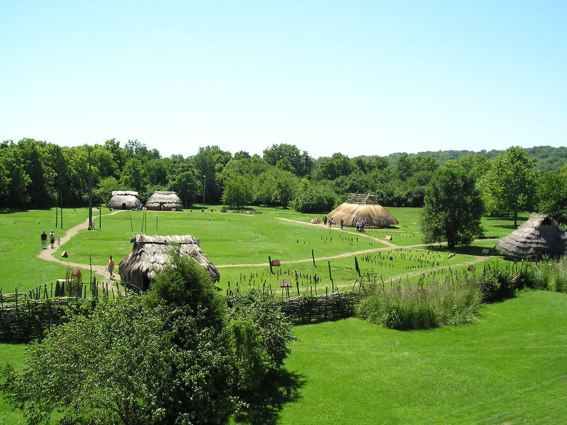
The reconstructed settlement covers approximately 3 acres, or 1.2 hectares, and follows a circular plan beside the Great Miami River. Its arrangement is based on the excavated village, with houses grouped into northern, southern, and western zones. The open-air museum includes reconstructed dwellings, a central plaza, gardens, and five houses. A garden and planted prairie represent aspects of the thirteenth-century environment.
Houses and Defensive Works
At one stage, the village contained approximately 27 houses or huts. The dwellings were enclosed by defensive palisades that changed as the settlement developed. An inner palisade surrounded the houses during the first phase, while an outer palisade enclosed the settlement in the third phase. A southwestern house appears to have maintained close relationships with both the western and southern groups. It may have been the oldest house and possibly the residence of the village founders. The large western house belonged to the early phase and may have begun as a smaller structure.
Red Cedar House
The Red Cedar House was built during the third phase from giant arborvitae wood. It had a rampart and ditch and has been interpreted as a high-status structure. Its construction and its position near the central ceremonial area have been associated with social ranking and Mississippian influence.
Central Plaza and Material Evidence
The central plaza contained a group of wooden posts whose arrangement has been interpreted as an installation for astronomical observation. Shell-tempered pottery and pottery with negative-painted designs indicate connections with Mississippian traditions. Burial arrangements also display features interpreted as Mississippian influences. Material from SunWatch that cannot be displayed at the village is presented and interpreted at the Boonshoft Museum of Discovery in Dayton.