Tiwanaku: Religious and Political Centre of a Pre-Columbian Andean Culture
Site at a Glance
- Rating
- 4.6
- Popularity
- Low
- Country
- Bolivia
- Primary era
- Medieval
- Eras represented
- Classical, Medieval
- Civilizations
- Tiwanaku
- Site type
- City
On this page23 sections
History
Tiwanaku is a major pre-Columbian archaeological site in western Bolivia, built by the Tiwanaku culture on the high Altiplano. The settlement developed between approximately 300 BC and AD 1000 and became a religious, administrative, political, and economic centre, as well as a pilgrimage destination. It lies at about 3,850 to 4,000 metres above sea level, near the intermittently dry Tiwanaku River and approximately 15 to 17 kilometres south or southeast of Lake Titicaca.
Name and early development
The settlement’s original name is unknown. The Jesuit chronicler Bernabé Cobo recorded the name Taypi Qala, or Taypikala, meaning “stone in the center,” but its connection with the settlement’s original indigenous name remains uncertain. Other historical forms include Tiahuanaco, Tiahuanacu, and Tihuanaku. The earliest chronology of the site is disputed. Archaeological assessments generally place its establishment no earlier than about 200 to 300 BC, while a statistical analysis of radiocarbon dates has proposed a foundation around AD 110, with a 68-percent probability range of AD 50 to 170. Much earlier proposed dates, including an occupation around 1580 BC and the prehistoric chronology advanced by Arthur Posnansky, are no longer generally accepted.
One chronological model places the earliest settlement traces in the fifteenth century BC, while ceramic sequences and radiocarbon dating more securely show development between about 300 BC and AD 1000. Tiwanaku had become a major religious and cultural centre by around 300 BC. Its principal architectural and political florescence occurred between approximately AD 600 and 900, when the settlement reached an estimated maximum extent of about four to six square kilometres.
Economy and regional influence
Tiwanaku’s economy combined agriculture, pastoralism, craft production, and long-distance exchange. Cultivation used rain-fed farming, irrigation, storage, and raised fields known as suka kollus or camellones. These fields were separated by water channels that could assist drainage, retain moisture and sediment, and reduce frost exposure. Their productivity, management, and capacity to support the population remain debated, and Tiwanaku was probably dependent primarily on rain-fed agriculture rather than standing directly on the ancient lakeshore.
At the height of its influence, Tiwanaku-related settlements and material extended across the southern and central Andes, including the Atacama region, northern Chile, parts of northern Argentina, Cochabamba, and the Moquegua region of Peru. This distribution may reflect direct political control, migration, colonies, exchange, or the adoption of Tiwanaku material culture by other communities. The precise relationship between these possibilities remains uncertain.
Tiwanaku also maintained important connections with the contemporary Wari polity, a major Andean society centred in present-day Peru. The two traditions shared motifs from the Southern Andean Iconographic Series, including front-facing supernatural figures and bird-human imagery, but their political and economic relationship is not established. The language spoken by the Tiwanaku population is likewise uncertain. Puquina has been proposed as a likely language, while other interpretations connect the population with ancestors of later Aymara- or Quechua-speaking communities.
Decline and abandonment
Tiwanaku declined and was largely abandoned around the end of the first millennium AD, approximately between AD 1000 and 1100. Increasing aridity and drought probably placed pressure on its agricultural systems, although the precise causes of the collapse remain debated. Internal social instability and wider political changes have also been proposed. By the time the Inca reached the region, the settlement had already been abandoned.
Inca rulers nevertheless admired Tiwanaku’s monumental stonework. Huayna Capac reportedly expressed astonishment at the ruins, while Pachacuti inspected the buildings and ordered that their construction be studied for possible emulation at Cuzco. In 1549, Pedro Cieza de León recorded the ruins while searching for the Inca capital of Qullasuyu. Local inhabitants told him that the monuments predated the Inca and could not identify their builders. Bernabé Cobo visited in 1610 and recorded traditions concerning the site’s name and significance.
Colonial damage and archaeological investigation
During the Spanish colonial period and into the twentieth century, Tiwanaku was looted and treated as a quarry. Stone was taken for churches, houses, public buildings, and railway construction. Military personnel also used monuments, including the Sun Gate, for target practice. The most severe modern destruction occurred during the early twentieth-century railway construction between La Paz and Guaqui, when numerous monumental structures, statues, and stelae were blasted with dynamite.
Georges Courty directed the first official excavations in 1903 and 1904. Several features uncovered by his French mission were later destroyed, including a building east of Kalasasaya that had stone faces set into its walls. Wendell C. Bennett directed the first stratigraphic excavation in 1934. Carlos Ponce Sanginés carried out extensive excavations and reconstructions from the late 1950s into the early 1980s, followed by major academically based investigations directed by Alan L. Kolata and Oswaldo Rivera from 1978 through the 1990s. Modern work has continued around the monumental core, including research by Bolivian archaeological authorities and the Pumapunku-Akapana Archaeological Project.
Early documentation by Pedro Cieza de León, Bernabé Cobo, Alcide d’Orbigny, Ephraim George Squier, Léonce Angrand, Alphons Stübel, Max Uhle, and Adolph Bandelier helped preserve information about features later damaged or altered. Stübel and Uhle’s 1892 study was an important early systematic treatment of the ruins, while Bandelier produced an influential map. Arthur Posnansky contributed valuable records, including historical photographs, but also promoted speculative interpretations of Tiwanaku. From 1928, Edmund Kiss pursued a pseudoarchaeological theory of an alleged Aryan origin that has no archaeological support.
Continuing cultural importance
Tiwanaku was inscribed in 2000 as the UNESCO World Heritage property “Tiwanaku: Spiritual and Political Centre of the Tiwanaku Culture.” The inscription recognizes the site as exceptional testimony to a cultural tradition or civilization that has disappeared and as an outstanding example of architecture, technology, or cultural landscape.
The site continues to hold sacred meaning for Aymara communities. In creation traditions, Wiraqucha or Viracocha, an Andean creator figure, emerges from Lake Titicaca and creates humans, animals, and the ordered world at Tiwanaku. Since 2006, the site has also been used for major state and indigenous ceremonies, including renewed winter-solstice celebrations. In November 2020, a symbolic transfer of the presidential command staff to Luis Arce and David Choquehuanca took place there.
Remains
The excavated monumental core is arranged approximately along the cardinal directions, although its orientation is not exact. Akapana and Kalasasaya are not precisely parallel, and a large moat may once have separated the central area from surrounding urban and agricultural zones. The interpretation of this feature as a sacred enclosure remains debated. The principal surviving groups include the Semi-Subterranean Temple, Kalasasaya, Putuni, Chunchukala, Kherikala, Kantatayita, Akapana, and Pumapunku, together with associated areas such as Akapana East, La K’arana, Kk’araña, Mollo Kontu, East Akapana, Ch’iji Jawira, and Lakakollu.
Courtyards and enclosures
Semi-Subterranean Temple
The Semi-Subterranean Temple is a sunken, approximately square enclosure and one of Tiwanaku’s oldest monumental structures. The wider complex measures about 26 by 28 metres, while its central court measures approximately 12 by 9 metres and lies about 1.8 to 2 metres below the surrounding ground. Sandstone pillars, smaller ashlar blocks, and numerous projecting stone heads of varied forms line its walls. Several monoliths were found within the court. The differing styles of the tenon heads have been interpreted as evidence that the structure was reused or modified for different purposes over time.
Kalasasaya
Kalasasaya is a large elevated rectangular courtyard or stone enclosure north of Akapana and west of the Semi-Subterranean Temple. Its dimensions are variously given as approximately 130 by 120 metres or 135 by 130 metres. The walls combine large upright sandstone slabs with smaller infill blocks, including some andesite. Most visible walling is modern reconstruction, and the reconstructed masonry is less precise than the original work. The principal gateway was also reconstructed without sufficient archaeological evidence. Additional parallel walling and a paved area may have extended in front of the present enclosure, but this interpretation remains uncertain.
Putuni
Putuni is a stone enclosure or platform complex with a central courtyard and a former monumental entrance. A polychrome stairway once led into the complex, but the stairway and gateway were destroyed soon after excavation. Putuni has also been associated with burial chambers and a drainage system, although the extent and interpretation of these features remain uncertain.
Gateways and carved imagery
Sun Gate
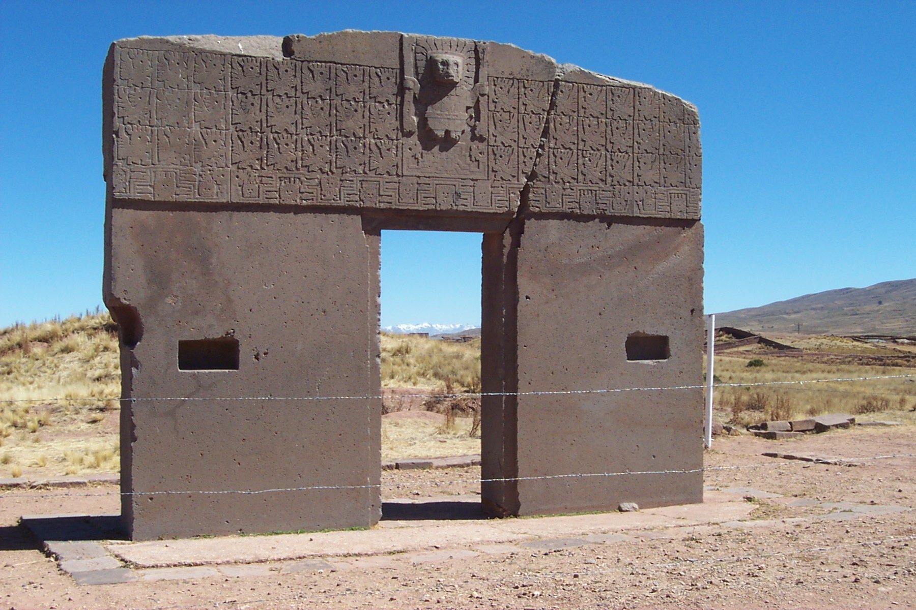
The Sun Gate is a monolithic andesite gateway now standing within Kalasasaya, although it is believed to have been moved from its original position. It is approximately 2.85 to 3 metres high and 3.75 to 3.82 metres wide, with an estimated weight of nine tonnes. The stone was found broken into two pieces, lying on the ground and partly buried, and was re-erected in 1908.
Its finely carved relief centres on a front-facing figure holding an object that some researchers interpret as a spear-thrower. Radiating elements surround the figure, while rows of human and bird-headed figures, stepped motifs, wave bands, and radiating disembodied heads complete the composition. The central figure may represent Viracocha, Thunupa, or another deity, but the identification remains uncertain. The relief has also been interpreted as a calendar, although that reading lacks definitive evidence. Its imagery is a major example of the Southern Andean Iconographic Series and has parallels on the Bennett and Ponce Monoliths, qirus, snuff trays, textiles, and other Tiwanaku objects.
Moon Gate
The Moon Gate is a narrower monolithic gateway approximately 200 metres northwest of Kalasasaya. Its figures and ornaments were carved with less precision than those of the Sun Gate. The doorway is unusually narrower at the bottom than at the top.
Kantatayita gateway and model
Kantatayita is a ruined temple complex beside Akapana with a lowered or partly sunken central area. Important carved stones include a large lintel and a carved architectural model. The former stone gateway has collapsed, leaving the lintel on the ground. Its motifs resemble those of Pumapunku, while the model offers evidence for the appearance and design of monumental architecture that has been damaged or lost.
Terraced platforms
Akapana
Akapana is a wholly artificial terraced platform mound built from megaliths, smaller stones, and earthen fill. It is generally estimated to have stood about 16 to 18 metres high, with maximum width estimates of roughly 200 to 257 metres and a length of about 192 to 197 metres. The mound originally had seven terraces and probably included a sunken court at its summit.
A deep depression occupies the summit and eastern side. Looters and treasure seekers enlarged it, while the exposed remains include retaining walls, possible rooms, stairways, drainage channels, and a complex internal water system. The terraces incorporated further drainage channels, and a monumental gateway or trilithic structure stood on or near the summit. A Chachapuma, a sculptural type combining feline and human characteristics, was found at the base of the western stairway holding a severed human head between its claws. Human remains and fragmented bodies around Akapana have been interpreted as possible sacrificial dedications, although their precise ritual context remains uncertain.
Akapana East
Akapana East lies east of the early settlement and may have marked a boundary between ceremonial and urban areas. Several buildings stood on a carefully prepared sand-and-clay floor. Yellow and red clays were used in different areas, apparently for visual or aesthetic purposes, and the area was kept free of domestic refuse.
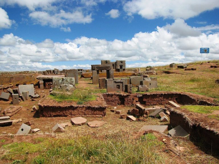
Pumapunku
Pumapunku is a wholly artificial terraced platform aligned approximately east-west. It contains monumental channels, courts, an esplanade, and large megalithic architectural elements. Its dimensions are approximately 167.36 metres north to south, 116.7 metres east to west, and 5 metres high, although other descriptions give somewhat different measurements.
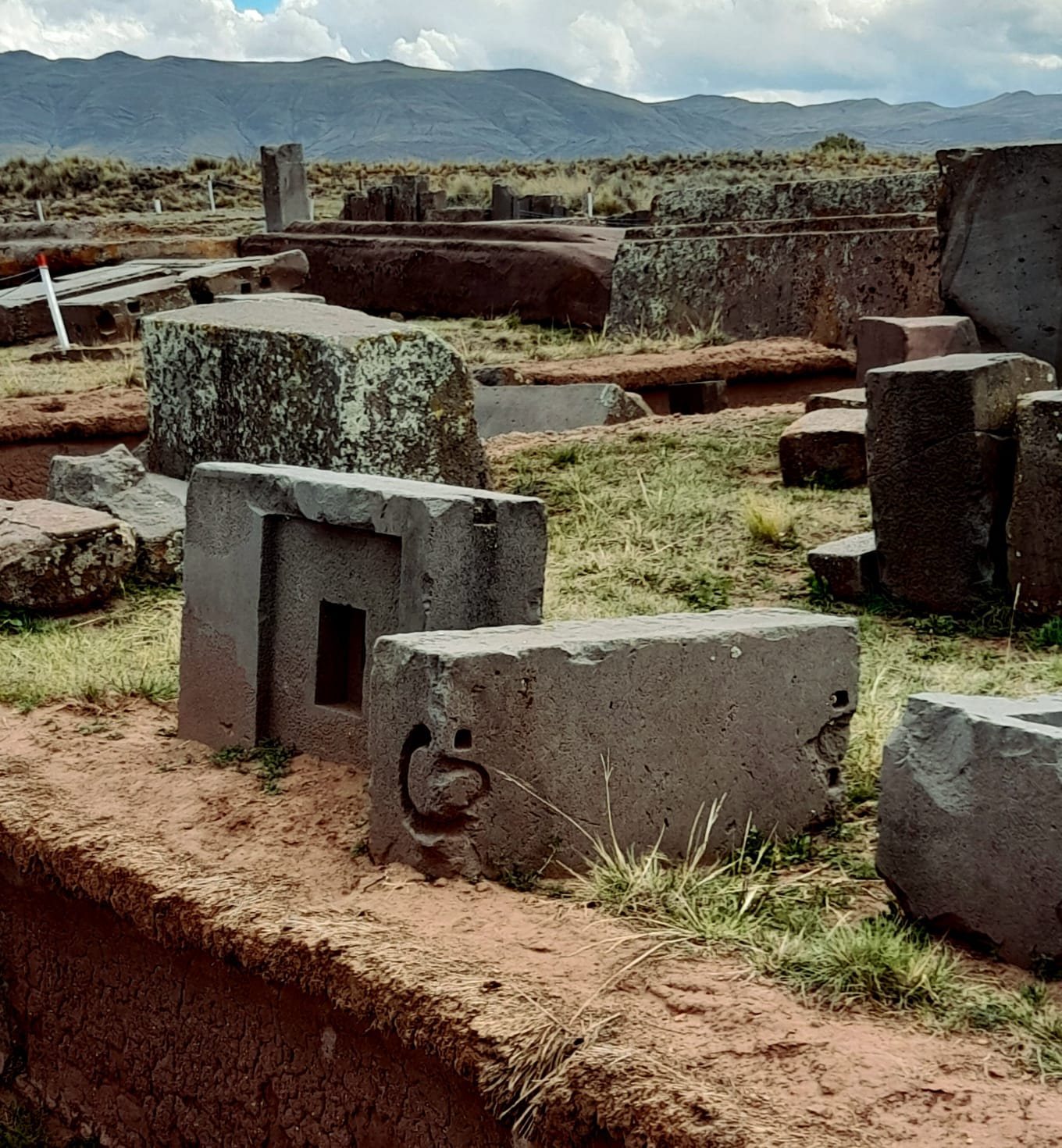
A major stone terrace, the Plataforma Litica, measures approximately 6.75 by 38.72 metres. It contains the largest known block at Tiwanaku, estimated at about 131 metric tonnes, and another major block estimated at approximately 85 tonnes. Numerous standardized and finely finished andesite blocks lie among large sandstone slabs. The stones were arranged in complex, puzzle-like configurations. Motifs were often completed on separate blocks before assembly, and standardized gateways and other architectural elements were produced in monumental and miniature forms.
Virtual reconstruction based on approximately 150 surviving pieces has indicated that Pumapunku could form a coherent local architectural design rather than an anomalous or non-local construction. Its monumental gateways were attached to other building elements with clamps, including concealed clamp systems. Some monumental and miniature gateways were aligned one behind another, creating an apparent perspective toward infinity.
Stonework and construction
Tiwanaku’s architecture uses sandstone, andesite, basalt, and other materials. Sandstone was quarried locally or in the nearby Tiwanaku mountain region, andesite came from the direction of Copacabana, and black basalt was obtained from the Oruro region. Diorite and limestone have also been identified among materials used across the wider site.
The masonry is characterized by exceptionally smooth surfaces, sharp edges, exact right angles, recessed frames and niches, and complex cuts into the stone. Some blocks contain narrow straight grooves and regularly spaced small holes. Many elements were assembled without mortar, while large stones were joined through carefully fitted surfaces and metal clamps. Pumapunku channels and other blocks contain clamp sockets in L, T, double-T, U, Y, and Z forms. Analyses of clamps from a Pumapunku channel identified a copper-arsenic-nickel bronze alloy that appears to have been cast directly into the sockets, drawing adjoining blocks together as the metal cooled.
The tools and methods used to produce these surfaces remain uncertain. Evidence has been interpreted as showing hammerstone pecking, polishing or grinding, and possibly the use of saws or files. Jean-Pierre Protzen and Stella Nair have argued that conventional bronze chisels and typical Inca stoneworking tools do not explain all the observed surfaces and angles. No tool has been conclusively associated with the construction of the site.
The Akapana Gate and Pumapunku Gateways I to III contain conical recesses about 8 to 14 centimetres in diameter and approximately 20 centimetres deep. Small holes were drilled from the front into the recesses, and many appear damaged as if force had been applied. They may have anchored gateways or lintels, but their exact function is unknown. Proposed explanations involving geopolymer, a cement-like artificial binding material formed through chemical reactions involving minerals and alkaline or organic substances, remain contested.
Other architectural complexes
Kherikala and Chunchukala were architectural complexes that once possessed monumental structures. Chunchukala was completely destroyed by looters shortly after its excavation during the 1903 French mission, leaving historical documentation as the principal evidence for its former appearance. The wider monumental core also includes La K’arana, Kk’araña, Mollo Kontu, East Akapana, Ch’iji Jawira, and Lakakollu.
A 2016 drone-based topographic survey identified previously unknown structures across approximately 411 hectares. These included a possible stone temple of about 17 hectares, roughly one hundred large circular or rectangular structures, and associated roads and canals. The survey also mapped features in the Mollo Kontu area and refined interpretations of incompletely excavated structures.
Sculpture and excavated objects
Tiwanaku sculptures were made mainly from sandstone and andesite, with important examples carved from basalt. Fragments of carved architraves in Berlin indicate that at least some sculpture was originally painted. The Bennett Monolith, an approximately 7.3-metre-high sculpture weighing about 20 tonnes, was excavated from the Semi-Subterranean Temple in 1932. It is now preserved and displayed in the local lithic museum rather than in its original archaeological setting.
The Ponce Monolith is an approximately 3.5-metre-high figure including its base, associated with Kalasasaya. Its front-facing face is schematic, and it holds a qiru, a distinctive Andean drinking vessel often used ceremonially, in its right hand and a snuff tray in its left. A cross was later incised on its right upper arm. The Fraile, or Monk, Monolith stands at the southwestern corner of the Kalasasaya platform. Other sculptures remain difficult to interpret, including an unusually enigmatic figure recorded by Stübel and Uhle.
Local museum collections include excavated ceramics, stone tools, stone sculptures, human remains, bronze objects, and ritual vessels. Qirus are flaring cups decorated with camelids, birds of prey, human faces, or stepped geometric designs. Incense burners commonly take the forms of condors, pumas, jaguars, or llamas. Excavated human remains include examples of intentional cranial modification. Similar cranial forms at Tiwanaku-related sites in Moquegua have been used to argue for migration or close links between those communities and Tiwanaku, although wider population relationships remain debated.
Condition and reconstruction
Much of the visible fabric consists of ruined foundations and heavily reconstructed walls. The reconstruction of Kalasasaya lacks adequate evidence, while restoration work on Akapana was halted in 2009 after UNESCO objections because the platform had been faced with adobe without establishing that this represented its original appearance.
Natural weathering, especially the flaking of sandstone surfaces, has obscured carved details and complicated reconstruction of original finishes. Stone removed from the site was reused in local churches, houses, and public furniture, further reducing the survival and archaeological clarity of the original architecture. Historical photographs, archaeological evidence, digital modelling, and 3D printing have nevertheless been used to propose possible forms for Pumapunku and other damaged structures.